1. Introduction
In many cases, reconstructing the evolution of a col-lision boundary is a difficult task, because large domains have disappeared as a consequence of sub-duction and underplating. However, significant rem-nants of deformed stratigraphic units are present as slices in and around the collision suture zones. They enable one to understand the history of convergence between two plates, provided that the structural pat-tern and the evolution of the suture zone are deci-phered. The suture zone may be the present plate boundary in the active orogenic belt, and may have played a different role at an earlier stage in its geologi-cal history. For example, it may have been a submarine trench or another major zone of weakness before the collision occurred. Thus, research on the evolution of the collision suture zone can help to reconstruct the convergent plate framework prior to, and during, colli-sion. As an oblique collision area, Taiwan offers an
excellent opportunity to observe the evolution of an arc–continent collision suture zone (Fig. 1).
The Longitudinal Valley of east Taiwan has gener-ally been considered as the ‘suture’ between the Luzon arc and the Eurasian continental margin. Across the Longitudinal Valley a present-day relative velocity of about 3 cm/yr has been detected by geodetic means (Yu & Liu, 1989; Lee & Angelier, 1993; Yu, Chen & Kuo, 1997; Angelier et al. 2000; Lee et al. 2001; Yu & Kuo, 2001). Many authors believe that prior to the arc–continent collision this Longitudinal Valley zone was not the site of subduction (that is, a submarine trench) but had originated as a submarine arc–prism boundary (Fig. 1) (Suppe & Liou, 1979; Page & Suppe, 1981; Huang et al. 1997, 2000; Byrne, 1998; Chang, Angelier & Huang, 2000). This inference was supported by geological observations of the Lichi Mélange, a distinct unit exposed east of the Longitudinal Valley and around the southwestern tip of the emerged Coastal Range.
In this paper we discuss the evolution of eastern and southern Taiwan, from subduction to collision, based
Structural evolution and significance of a mélange in a collision
belt: the Lichi Mélange and the Taiwan arc–continent collision
C. P. C H A N G * § , J. A N G E L I E R * , C. Y. H UA N G † & C. S. L I U ‡
*Laboratoire de Tectonique Quantitative, Université P. & M. Curie, Case 129, T 25-26, E 1, 4 place Jussieu, 75252 Paris Cedex 05, France
†Department of Geosciences, National Taiwan University, 245 Choushan Road, Taipei, Taiwan, ROC ‡Institute of Oceanography, National Taiwan University, Taipei, Taiwan, ROC
(Received 13 February 2001; accepted 22 August 2001)
Abstract – The analysis of ‘mélanges’ of various types (sedimentary, diapiric, tectonic and polygenetic)
is generally difficult and depends on a variety of criteria. However, understanding the nature and origin of mélanges is crucial to deciphering the evolution of some mountain belts. The Lichi Mélange of the Taiwan Coastal Range is juxtaposed against remnant forearc basin sequences by thrust faults and is composed of exotic ophiolite and sedimentary blocks, with sizes ranging from metres to kilome-tres, and coherent turbidite beds, all embedded in a sheared scaly argillaceous matrix. The Lichi Mélange has been interpreted either as a subduction complex, or as an olistostrome. By separating four main deformation levels based on the degree of disruption within the Lichi Mélange and adjacent sedimentary rocks, we have made new detailed geological maps and structural profiles in two key areas of the Lichi Mélange. We paid particular attention to the original stratigraphic relationships between the mélange and the adjacent flysch formation. Our field results compared with submarine seismic profiles suggest that the present-day structure of the Lichi Mélange results mainly from the shearing of lower forearc basin sequences, rather than from a subduction complex or a mere olistostrome. In Late Miocene time, because lithospheric subduction turned into arc–continent collision in the southern Taiwan area, the site of the proto-Manila trench changed from an active plate boundary into a defor-mation zone with several thrusts. A new plate suture zone between the Eurasian plate (eastern Central Range) and the Philippine Sea plate (Coastal Range) was therefore formed along the Longitudinal Valley. The Longitudinal Valley originated as a submarine arc–prism boundary, an innate weak zone within the overriding plate, and has become a prominent tectonic feature of the arc–continent colli-sion. This inference is supported by observations on the Lichi Mélange in the Coastal Range and the Huatung Ridge off southeastern Taiwan.
principally on consideration of the evolution of Lichi Mélange and the Huatung Ridge off southeastern Taiwan.
2. Tectonic setting of Taiwan
Taiwan is located on the southeastern margin of the Eurasian continent (Fig. 1). Palaeocene–Eocene rift-ing led to the development of a series of NE-trendrift-ing grabens on the southeastern edge of this continent (Sun, 1982; Huang et al. 2001). From Oligocene to Middle Miocene time, widespread rifting resulted in the formation of oceanic lithosphere in the South China Sea (Taylor & Hayes, 1983). Soon after it was generated in about Early Miocene time, the South China Sea oceanic lithosphere subducted beneath the northwestward-moving Philippine Sea plate along the
Manila trench (Holloway, 1982). The present Luzon arc was therefore formed on the Philippine Sea plate. Continued subduction guided the Eurasian continent margin closer to the Luzon arc and resulted in an arc–continent collision in Late Miocene time (Fig. 2). This arc–continent collision formed the present Taiwan island (Suppe, 1981). The exact age of the onset of collision in Taiwan is still a matter of debate. The stratigraphic record in western and eastern Taiwan shows an increase in clastic sedimentation that occurred approximately 5 Ma ago, followed by a fur-ther increase approximately 3 Ma ago (Chang & Chi, 1983). Thus, the collision mountain belt was in exis-tence by 5 Ma.
Taiwan island consists of five morphotectonic units, all separated by major faults (Fig. 3): the Coastal Plain, the Western Foothills, the Hsüehshan Range,
Figure 1. Block diagram showing arc–continent collision and tectonic setting of Taiwan. Taiwan is situated in the active arc–continent collision region between the Eurasian continent and the Philippine Sea plate. South of Taiwan, the oceanic crust of the South China Sea (32–15 Ma) is subducting beneath the Philippine Sea plate along the Manila trench. To the east, the Philippine Sea plate is being consumed beneath the Eurasian continent along the Ryukyu trench. The Philippine Sea plate is moving northwestward at 310° at a rate of 82 mm/yr (Yu, Chen & Kuo, 1997). The Luzon arc (trending at about 355°) on the Philippine Sea plate is colliding with the Asian continent (trending at about 060°) and formed the Coastal Range in eastern Taiwan. Because the Quaternary collision that forms Taiwan island is a typical oblique arc–continent collision, the orogenic belt has been propagating southward (Suppe, 1981). On land in Taiwan, one observes the outcome of this collision; in the area off southeastern Taiwan, the process of subduction is still ongoing (see discussion in text). The detailed structure is shown in cross-section in Figure 11. FK – Fukang Sandstone; HTR – Huatung Ridge; LS – Loshui Sandstone; LV – Longitudinal Valley fault zone; NLR – North Luzon Ridge; NLT – North Luzon Trough; SLT – Southern Longitudinal Trough.
the Central Range and the Coastal Range. West of the Longitudinal Valley, the Coastal Plain, Western Foothills and Hsüehshan Range are composed of Cenozoic shallow-marine siliciclastics, whereas the western Central Range is composed of Miocene deep-marine turbidites and the eastern Central Range is composed of Mesozoic to Late Palaeozoic metamor-phic rocks. The age, lithology, and relationship with adjacent rocks suggest that these units all originated as part of the underthrust Eurasian continent (Ho, 1975). In contrast, east of the Longitudinal Valley, the Coastal Range belongs to the Philippine Sea plate and represents a section of the Luzon arc that has been accreted onto the telescoped uplifted Eurasian conti-nent (Fig. 3). The Longitudinal Valley between the Central Range and the Coastal Range thus marks the collision suture between rocks of Eurasian affinity and rocks that originated on the Philippine Sea plate.
The convergence velocity between the Eurasian plate and the Philippine Sea plate is about 7 cm/yr and augments progressively southward (Seno, 1977; Seno, Stein & Gripp, 1993). In the Taiwan area, recent GPS data show that the North Luzon arc is moving towards the Asian continental margin with a velocity of about 8.2 cm/yr on an azimuth of 310° (Yu, Chen & Kuo, 1997). The arc–continent collision in Taiwan is an oblique collision resulting in a time–space equivalence along the strike of orogen, so that the onset of colli-sion is more and more recent from northeast to south-west (Suppe, 1981). Based on kinematic reasoning and assuming a constant velocity of convergence, kine-matic interpretations have been presented (Suppe, 1981; Barrier, 1985). Byrne (1998) considered the trend of the south China continent margin as 060°, the trend of the Luzon arc just south of Taiwan as 355°, and a plate convergence vector of 70 km/my that trends 310°. In his model, the Longitudinal Valley rep-resents the ‘suture’ between the Luzon arc and the Taiwan accretionary prism, and a propagation rate along this suture of about 4.0 to 4.5 cm/yr has been obtained. Three distinct tectonic stages can be sepa-rated in the Taiwan arc–continent collision area by considering geological and geophysical characteristics. As Figure 1 shows, from south to north these stages are: subduction, initial collision and advanced colli-sion (Huang et al. 1997).
3. Previous studies of the Lichi Mélange
The Coastal Range extends north–south along the east side of Taiwan island over a length of about 150 km with an average width of about 10 km (Fig. 4). The sequences of the Coastal Range comprise about 6000–8000 metres of marine and fluvial sedimentary and volcanic rocks of Neogene–Quaternary age (Hsu, 1956, 1976; Chang, 1967, 1969). These rocks may be divided into four rock-stratigraphic units: (1) the Miocene volcanic rocks of the Tuluanshan Formation,
(2) Pliocene–Pleistocene deep-sea turbidites of the Takangkou Formation, (3) the Lichi Mélange and (4) the Pinanshan Conglomerate (Fig. 4).
The Lichi Mélange is widely distributed along the southwestern flank of the Coastal Range, which is composed of chaotic mudstones intermixed with ‘exotic’ blocks of various size and lithology. The most characteristic lithological feature of the Lichi Mélange lies in the presence of intensely sheared mudstones without distinctive stratification, and the most com-mon mesoscopic structure is the scaly foliation. The curviplanar surfaces of this penetrative scaly foliation are generally polished and bear aligned minerals and slickensides (Hsu, 1976; Teng, 1981; Chen, 1991, 1997; Chang, Angelier & Huang, 2000). However, some lay-ers of pebbly mudstones and coherent stratification have been locally reported (Chang, 1969; Liou, Suppe & Ernst, 1977; Page, 1978; Page & Suppe, 1981; Barrier & Muller, 1984). The blocks inside the mélange may reach kilometric size and are generally angular in shape. Most small blocks (decametric or smaller) are heavily sheared and polished, but many large blocks appear almost undeformed (Teng et al. 1988). In terms of lithology, the blocks considered as ‘exotic’ belong to three main types: (1) ophiolitic rocks, including basic to ultrabasic rocks, (2) sedimentary rocks, including
Figure 2. Travel path of the Luzon arc relative to South China continental margin (modified after Teng, 1987). The palaeotectonic configuration (10 Ma ago) of Ryukyu– Luzon arcs and the trenches are shown by unfilled island outlines and dashed lines. Curved thin arrows show the migration path of Luzon arc, that was about 500 km away from its present position in Late Miocene time.
sandstones, sandstone/shale interbeds, shales, and limestones and (3) andesitic rocks, including volcanic breccias, tuffs, and volcaniclastic turbidites (Hsu, 1976; Liou, Lan & Ernst, 1977; Page & Suppe, 1981).
Micropalaeontological analyses demonstrated a chaotic mixing of fossils indicative of Miocene to Pliocene ages, and the definite biostratigraphic sequence is difficult to identify (Chang, 1967, 1969; Huang, 1969; Chi, 1982). Ho (1977) advocated that the Lichi Mélange was emplaced in Pleistocene time and thus assigned the Lichi Mélange a Plio-Pleistocene age. Page & Suppe (1981), putting empha-sis on the youngest age shown by the fossil assemblages, concluded that the Lichi Mélange was deposited in Late Pliocene time. Teng & Lo (1985) pro-posed a continued mixing from Oligocene to Late Pliocene time, based on consideration of various fossil ages inside the Lichi Mélange.
The estimation of the thickness of the Lichi Mélange is based on the log of a Chinese Petroleum Corporation well near Houtzeshan in the southern-most Coastal Range (Meng & Chiang, 1965). The well penetrated 1056 m without reaching the base, which shows that the thickness of the Lichi Mélange, whether truly stratigraphic or actually tectonic, is at least 1000 m. The well penetrated a number of slabs of basalt and other basic rocks embedded in the muddy matrix, demonstrating that the composition of the
Lichi Mélange is chaotic at depth as well as at the sur-face (Hsu, 1976). The contact between the Lichi Mélange and other rock units of the Coastal Range is observed to be mostly faulted (Hsu, 1976), but there is local interfingering with strata of the Takangkou Formation (Page & Suppe, 1981; Barrier & Muller, 1984; Chang, Angelier & Huang, 2000). The best evi-dence for stratigraphic interfingering is cropped out in the area of Muken River, between the Lichi Mélange and the lower Takangkou flysch, which is Early Pliocene in age (NN14–NN15 nannoplankton zones: M. Lee, unpub. M.Sc. thesis, Taiwan Univ., 1984).
The origin of the Lichi Mélange has been the sub-ject of much controversy. Two main hypotheses are illustrated in Figure 5. Because of the intense scaly foliation and the existence of the exotic blocks, many geologists think that the Lichi Mélange is a ‘subduc-tion complex’ (Fig. 5a) formed by tectonic processes as the South China Sea oceanic crust was subducted (Biq, 1971, 1973; Karig, 1973; Teng, 1981; Hsu, 1988; Chen, 1991, 1997). However, because of the occur-rence of well-bedded units in the mélange, as well as coherent turbidites, many other geologists considered the Lichi Mélange as an ‘olistostrome’ (Hsu, 1956; Wang, 1976; Ernst, 1977; Ho, 1977, 1979; Liou, Suppe & Ernst, 1977; Liou & Ernst, 1979; Page & Suppe, 1981; Barrier & Muller, 1984) that developed between the outer arc and a forearc basin (Fig. 5b). According
Figure 3. Tectonostratigraphic summary of the units of Taiwan orogen. Simplified geological map (inset) indicates the approxi-mate profile location.
to the model of subduction complex origin, the Longitudinal Valley fault is a relic of the former sub-duction trench and was an active major structure before and during arc–continent collision (Fig. 5a). In
contrast, in the olistostrome model (Fig. 5b), the Longitudinal Valley represents a part of a forearc basin, which was a relatively quiet region before the arc–continent collision.
Figure 4. General geological map of the Coastal Range and summary of stratigraphic–tectonic relationships between the main formations. The Lichi Mélange is distributed around the southwestern flank of the Coastal Range, but emphasis is put on some small outcrops along or inside the Coastal Range: near Futien in the northern Coastal Range (Teng, 1981), near Fongping in the eastern Coastal Range (W. S. Chen, unpub. Ph.D. thesis, Taiwan Univ., 1988) and in the Loho basin of the central Coastal Range. The study areas of Figures 6, 7 and 8a are shown.
The significance of the mélange is crucial in any reconstruction of the geological history of eastern Taiwan and especially of the Longitudinal Valley, the so-called ‘suture’ between the Eurasian continental margin and the Luzon arc. The Lichi Mélange in the Coastal Range is therefore a key to the interpretation of the evolution of Taiwan orogenic belt. For this reason, a detailed examination of the field evidence concerning the Lichi Mélange outcrops is the primary subject discussed below.
4. Method
For the field studies, our detailed mapping aimed espe-cially at distinguishing sub-units within the Lichi Mélange (considered in previous geological maps as a single unit). For this purpose, we considered not only the lithological properties, but also the degree of frac-ture of the rocks following the method used by Raymond (1984). Four main types (α,β,γand δ) of rock were recognized in this study. The first two types correspond to the lowest levels of deformation and disruption in the Lichi Mélange. They include the ‘coherent units’ where internal continuity of the strata is preserved (type α) and the ‘broken units’ where this continuity is still detectable but locally disrupted (type
β); a common characteristic of these two types is the absence of exotic blocks. In the field it is difficult or impossible to distinguish the outcrops of type α (‘coherent units’) from the outcrops of Takangkou flysch. This observation is important because it suggests that some close relationship exists between the Lichi Mélange and the Takangkou Formation.
The next two types correspond to the highest levels of deformation and disruption; the internal continuity of strata is no longer observable while exotic blocks become common. These two types include the ‘dis-membered units’ where the shearing still remains limited (type γ) and the ‘mélanges’ sensu stricto which have undergone strong shearing (type δ). The exotic blocks in type γ sub-units are generally of the same nature (sandstone of Takangkou flysch), whereas in type δ they vary in nature (including sandstone of Takangkou flysch, quartzose sandstones, tuffaceous sandstones, andesite and ophiolitic rocks) and their distribution becomes chaotic.
The most common mesoscopic structure in the Lichi Mélange is the scaly foliation with the aligned minerals and slickensides on the surface. Therefore, we have also carried out a tectonic analysis based on the numerical inversion of minor fault slip data in the Lichi Mélange. The inversion methods that we used have been described in detail in previous papers (Angelier, 1984, 1990). These methods consist of determining the best fitting reduced palaeostress ten-sor for a given fault-slip data set, thus identifying the attitudes of the three principal stress axes (maximum compressional stress σ1, intermediate stress σ2 and minimum stress σ3) and the ratio φ= (σ2 –σ3)/(σ1 –σ3) between principal stress magnitudes.
After the onshore field study, we extended our atten-tion into the offshore area. As menatten-tioned before, the Taiwan arc–continent collision provides a case exam-ple of oblique collision. As a result, one can recon-struct the tectonic evolution, from subduction to collision, by comparing the southern section with the northern one. For the area off southeastern Taiwan, in the active collision zone, our discussion was princi-pally based on two seismic profiles. The six-channel seismic data were obtained by a marine geophysical survey conducted in 1990 aboard the R/V Moana Wave of the University of Hawaii.
5. Results
5.a. Field based studies of the Lichi Mélange
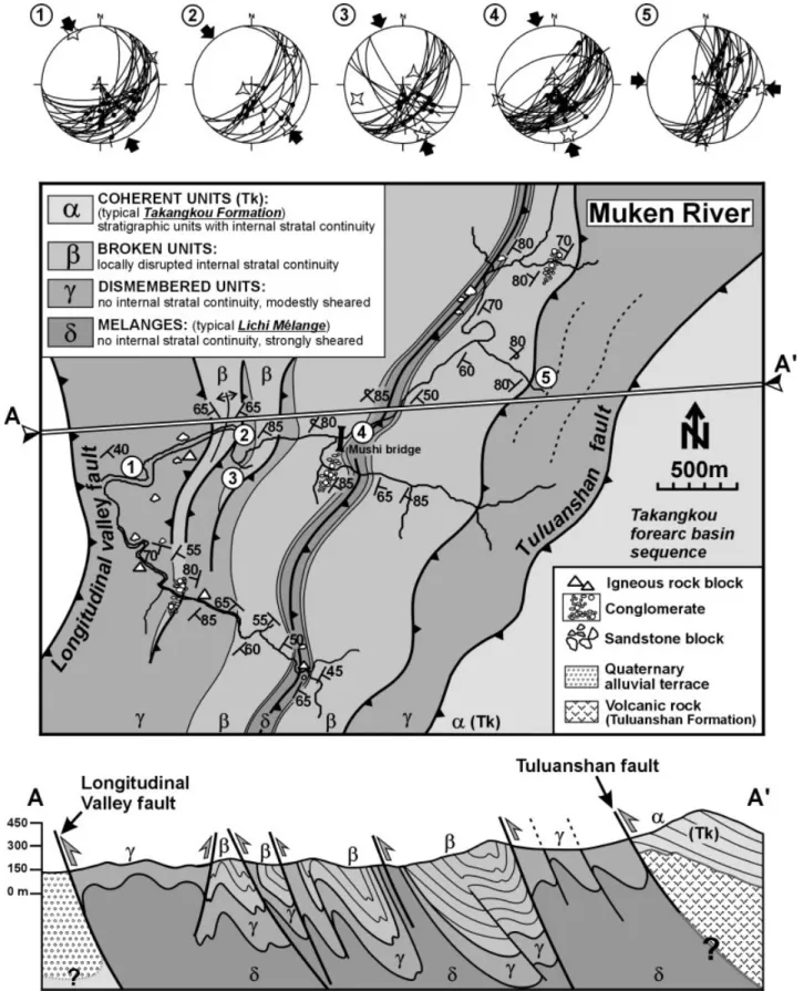
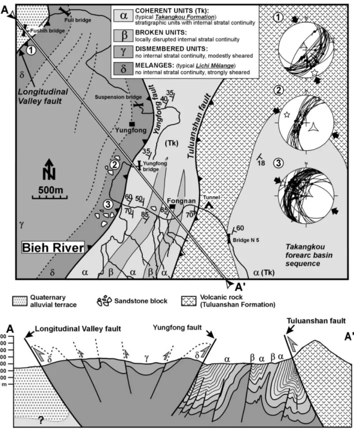
Several rivers cut across the Lichi Mélange; the Muken and Bieh rivers in the southern and the central parts of the Coastal Range offer the best outcrops. Figures 6 and 7 show geological maps of these key areas (Chang, Angelier & Huang, 2000), as well as the corresponding cross-sections. Careful consideration of the structure, especially the dips of fold limbs and the offsets of
Figure 5. Comparison of models for the origin of the Lichi Mélange. (a) Illustration of the ‘subduction complex’ hypothesis. In this model, the Lichi Mélange is the relic of a subduction complex, composed of oceanic sediments and upper crustal material scraped off the South China Sea oceanic crust; the Longitudinal Valley is the proto-Manila trench. (b) The ‘olistostrome’ origin hypothesis. In this model, the Lichi Mélange is an olistostrome deposited in the eastern forearc basin, its source being the eastern flank of the outer non-volcanic arc (accretionary prism).
thrusts and reverse faults in relation to the position of the different types at the surface, revealed that in general the sub-units of type δcrop out in the core of anticlines (e.g. in the middle of the map and cross-section in Fig. 6) whereas the sub-units of type αare exposed in the axial portion of synclines (e.g. near Fongnan in the map and cross-section of Fig. 7). Similar geometric relationships indicate an intermedi-ate position for sub-units βand γ(see the tight folds in the central domain of Fig. 6, and the large syncline inside the 2.5 km wide pop-up structure in the western half of Fig. 7).
In the area of the Muken River (Fig. 6), the Lichi Mélange consists of strongly sheared mudstone, with many intercalations of non-sheared and well-bedded coherent turbidites. The thickness of the sheared and non-sheared coherent turbidite sections ranges from several metres to several tens of metres. The contacts between these turbidites and the matrix of the Lichi Mélange vary in nature. Sometimes, there are clearly faults, but in many other cases there is no sharp boundary between the turbidites and the typical mélange, rather a zone of gradual change. Accompany-ing the strongly sheared mudstones (sub-units of type δ), there are some dismembered quartzose sandstone, andesitic rock and ophiolite blocks. In this area, all steep-dipping thrust faults and tight folds are west-verging, with a single exception (the steep-dipping backthrust east of the Longitudinal Valley fault; see Fig. 6). The narrow fold that runs in the middle of the map and section is a tight anticline with intense reverse shear near its axis, a feature that we interpret as a thrust-cut anticline. A more intriguing feature is the major Tuluanshan fault itself in the eastern portion of the map and cross-section of Figure 6, because although the structural analysis unambiguously indi-cates that it is a west-verging thrust (as for other areas of the southwestern Coastal Range along this large fault), the formation (α-type) that crops out in the hanging wall is structurally higher than that of the footwall (γ-type). This particular structure may exist either because of variations in the relative structural position of the sub-units that were defined based on deformation criteria instead of stratigraphic ones, or because of a possible interaction between thrusting and backthrusting (not illustrated in section) that may effectively produce such an apparent anomaly (Chang, Angelier & Huang, 2000).
Further north, a narrow volcanic crest (Tuluanshan Formation) separates the area of the Bieh River into two parts (Fig. 7). The eastern part is composed of the less deformed Takangkou Formation; in contrast, the material in the western part is more deformed and contains some exotic blocks. It may well be possible that the Takangkou Formation in the eastern part overlies the rigid Tuluanshan Formation that sustains the compressive tectonic stress, so that the covering strata could have minimum deformation. However, in
the western part, the volcanic basement is no longer recognized due to strong deformation (Fig. 7).
In the western part of the Bieh River area, there are three principal faults (Fig. 7). To the west, the Lichi Mélange (unit δ) has overthrust the Quaternary fluvial conglomerates. The thrust fault is clearly observable with a strike of N20°–40°E and an eastward dip of 70°–80°. This thrust fault is a segment of the active Longitudinal Valley fault. The eastern boundary of the Lichi Mélange (unit δ) is formed by another major thrust fault, the Yungfong fault, a backthrust over the Takangkou Formation (unit α), with a fault plane striking N20°E and west-dipping 70°–50°. Within the Takangkou Formation in this area, we found two small sheared zones with some features of the Lichi Mélange (clay matrix and sandstone blocks), each zone about 150 m wide (Fig. 7). At the eastern end of this western part, the Takangkou Formation is overthrust by the Tuluanshan Formation, along the Tuluanshan fault.
Figures 6 and 7 also show our tectonic data and results in the areas of the Muken and Bieh rivers. NW-SE-trending compression clearly prevailed in both these areas, which is consistent with the plate conver-gence direction of 310° (Seno, Stein & Gripp, 1993). An interesting aspect of the data is that in most cases the patterns of minor conjugate fault slips exhibit nearly vertical and horizontal symmetry planes, whereas the folded layers that they affect show a variety of attitudes. This indicates that in most cases the observed slickenside lineations developed at a late stage in the tectonic history. This does not indicate that faulting occurred recently, but shows that pre-folding striations have often been erased and replaced by post-folding ones on most minor fault surfaces in the clay matrix of the Lichi Mélange. For this reason, it was not possible to carry out systematic backtilting restoration in our fault slip analysis (which would have been difficult because of the complex shapes of folds in the Lichi Mélange).
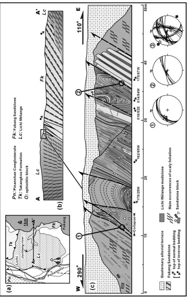
Figure 8 shows an outcrop of the Lichi Mélange which displays the relationship between the strongly sheared mudstone and a sandstone block. In the southern tip of the Coastal Range, the Lichi Mélange is widely distributed and turns to the east to surround the Takangkou Formation (see Fig. 4). A large quart-zose sandstone block, the so-called Fukang Sandstone, crops out east of the Lichi Mélange (Fig. 8a,b). The Fukang Sandstone occupies an area of some 3 km2 with a measurable total thickness of more than 390 m and has been considered as a huge exotic block tecton-ically emplaced in the Lichi Mélange (Sung, 1991). Figure 8c shows a contact between the Lichi Mélange and the Fukang Sandstone. In this contact zone, the Fukang Sandstone is cut by a series of reverse faults. The fault plane orientations are about 055°/45°W for fault 1 and about 070°/77°W for fault 2, consistent with the curvature of the contact between the Lichi Mélange and the Takangkou Formation in this area
Figure 6. Geological map and cross-section of the Muken River area. Location in Figure 4. Five stereographic plots of striated scaly foliations measured in area. Lower hemisphere equal-area projection, striated faults as thin curves with dots; inward-directed segments for reverse slip, outward-inward-directed ones for normal slip, double half segments for strike-slip; palaeostress axes as five-, four- and three-pointed stars for maximum compressive stress, intermediate stress and minimum stress, respectively. Large convergent and divergent arrows indicate directions of compression and extension, respectively.
Figure 7. Geological map and cross-section of the Bieh River area. Location in Figure 4. Three stereographic plots of striated scaly foliations measured in area. See Figure 6 caption for explanation of symbols.
(see Figs 4, 8). The palaeostress reconstructed from fault slip data in this outcrop resembles those from the areas of Muken and Bieh rivers.
Detailed studies of sedimentary structures and depositional environment of the Fukang Sandstone have been made by Huang & Fong (1986) and Sung (1991), and its age has been determined as Late Miocene based on nannofossil analysis (NN9–NN10) (Chi, 1982), which is older than the sedimentary sequence (NN13–NN19) in the Coastal Range. The general detrital composition of the Fukang Sandstone has been suggested to be very similar to that of the Miocene Loshui Sandstone (location shown in Fig. 1) of the Hengchun Peninsula (Sung, 1991). Byrne (1998) proposed, moreover, that the Loshui Sandstone is the primary source for the blocks of sandstone and con-glomerate in the Lichi Mélange. However, the present distance between the Loshui Sandstone and the Fukang Sandstone is now about 90 km (see Fig. 1). We consider therefore that the Fukang Sandstone block was incorporated into the Lichi Mélange by tec-tonic processes during arc–continent collision, and the distance between the Loshui Sandstone and the Fukang Sandstone may be due to movement on the Longitudinal Valley fault, a later active major fault discussed below.
5.b. From onshore to offshore Taiwan: the Huatung Ridge
Marine geology in the region between Taiwan and Luzon is characterized by convergent tectonics in the south and oblique arc–continent collision in the north (Huang et al. 1992). In the collision zone, six geologi-cal provinces are recognized (Fig. 1). They are, from west to east: the Manila trench, the accretionary prism of the Hengchun Ridge, the collision suture basin of the Southern Longitudinal Trough, the submarine mélange of the Huatung Ridge, the forearc basin of the Taitung–North Luzon Trough, and the volcanic arc of the North Luzon Ridge (Chen & Juang, 1986; Chen, Shieh & Shyr, 1988; Huang et al. 1992).
The Huatung Ridge (23°–21°10′N) is located between the Southern Longitudinal Trough to the west and the remnant forearc Taitung Trough (or the North Luzon Trough) to the east and is characterized by an irregular, rugged topography. The crest of the Huatung Ridge fluctuates between 800 and 1200 m below the sea-surface, and is approximately 100–500 m and 500–1300 m above the seafloor of the Southern Longitudinal Trough and the Taitung Trough, respec-tively (Huang & Yin, 1990). The Huatung Ridge is a bathymetric high connected to the southern Coastal Range and is characterized by low negative free-air
gravity and magnetic anomalies. It also contains deeply weathered sedimentary blocks with abraded deep-water Late Pliocene foraminifera and identical clay mineral compositions to those of the onshore Lichi Mélange (Huang et al. 1992; Huang, 1993). For these reasons, Huang et al. (1992) have suggested that the onshore Lichi Mélange can be traced southward into the offshore Huatung Ridge because they have the same geological origin.
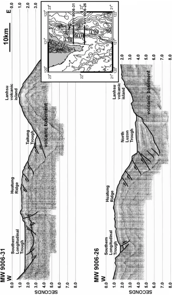
Figure 9 shows two seismic profiles across the Huatung Ridge. The profile MW 9006-26 cuts from the Hengchun Ridge through the south end of the Southern Longitudinal Trough to the south of the Lanhsu island. At this location, the Southern Longitudinal Trough has just begun to develop, and the sediments are not abundant. In the Huatung Ridge, the principal structure is the east-vergent fault (back-thrust). These back-thrusts are probably caused by the compression of the volcanic back-stop (Lee et al. 1992; Lundberg et al. 1997). In the North Luzon Trough, the sediments unconformably cover the Luzon volcanic basement. The western part of the sediments in the North Luzon Trough have been deformed by the backthrusts and form a drag fold (Fig. 9).
The profile MW 9006-31 cuts across the middle part of the Southern Longitudinal Trough, which is is wider and thicker in this area. There are some steep structures in this basin, probably caused by strike-slip faulting. Some diapiric structures can be observed in this basin and the evolution of these structures is probably controlled by high rate of sedimentation and compression between the volcanic back-stop and the accretionary prism of Hengchun Peninsula (Lee et al. 1992). In the eastern part of the Huatung Ridge, there are clearly some back-thrusts. East of the Huatung Ridge, there is little sediment in the forearc basin (Taitung Trough), because, to the north, a deep sub-marine channel between Lutao and Lanshu islands acts as the eastern outlet of Taitung Trough, trans-porting most sediments to the Philippine Sea plane (Lundberg, 1988; Liu, Su & Shyu, 1991; Lee et al. 1992).
On a larger, lithospheric scale, two tectonic profiles of Taiwan are shown in Figure 10. Results from recent research and modelling of the deep structure of Taiwan (e.g. Chemenda et al. 1997, 2001; Ma & Song, 1997; Shih et al. 1998; Yeh et al. 1998; Liu et al. 1999; Malavieille, 1999) help us to determine the deep crustal structures and the depth of the Mohorovicic discontinuity in these two profiles. In profile A, cutting across the Hengchun Peninsula and Lanhsu island, the former is the present accretionary prism and the later
Figure 8. (a) Geological map of the southern tip of the Coastal Range. Location in Figure 4. (b) Schematic structural profile of line A–A’ in Figure 8a. (c) Outcrop of a boundary between the Fukang Sandstone and the strongly sheared mudstone matrix of the Lichi Mélange. Location in Figure 8b. Three stereographic plots represent the striated scaly foliations on fault 1 (plot 1), fault 2 (plot 2) and the whole area (plot 3). See Figure 6 caption for explanation of symbols.
is the volcanic island. Between these two highs, the col-lision between the Luzon arc and the underplating Eurasian continent has back-thrusted and uplifted the forearc sequence to develop a ridge (the Huatung Ridge) and an intervening suture basin (the Southern Longitudinal Trough). No major tectonic feature, such as a décollement or a huge fault, can be observed in this area (see also the seismic profiles shown in Fig. 9). However, west of the Hengchun Peninsula, off southwestern Taiwan, several thrusts highlight the propagation of the deformation front (Reed et al. 1992; Huang et al. 2001). Profile ‘a’ thus illustrates the general tectonic framework of Taiwan at its initial col-lision stage. Note that at this early stage the forearc region is a relatively quiet region from a structural point of view.
Further north, profile ‘b’ (Fig. 10) cuts across the advanced collision zone. Between the Central Range and the Coastal Range, a new major active fault is well expressed, which is the Longitudinal Valley fault. This fault occupies the same site as the Southern Longitudinal Trough, as profile ‘a’ shows, and repre-sents the principal present-day zone of weakness and shortening in the Taiwan orogenic belt. In the regional structural framework, the Longitudinal Valley can be considered as the onshore extension of the arc–prism boundary. Considering the rocks on both sides, how-ever, it is certainly the major ‘suture’ between the Eurasian plate and the Philippine Sea plate. More pre-cisely, this most important linear structure of Taiwan island is a morphological structure that pre-dated the collision and became a major fault and suture zone during the subsequent advanced arc–continent colli-sion
6. Discussion
6.a. Structural evolution of the Lichi Mélange
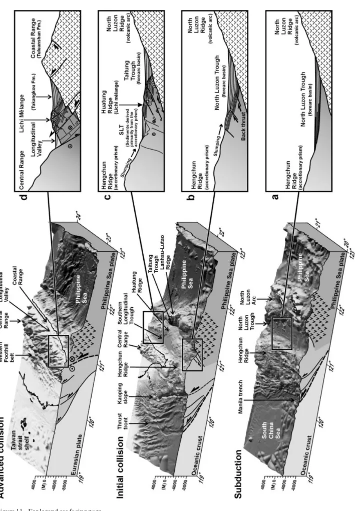
After considering the geological situation of the onshore Lichi Mélange and extrapolating it to the off-shore Huatung Ridge, we think that the structural evo-lution of the Lichi Mélange within the framework of Taiwan convergence can be discussed in four main stages (Fig. 11). Understanding the nature and signifi-cance of the Lichi Mélange and the Huatung Ridge provides a key to the reconstruction of this evolution.
The first stage (Fig. 11a) corresponds to Miocene time in Taiwan. The South China Sea oceanic crust was subducting beneath the Philippine Sea plate to generate an arc–trench system and a forearc basin (Fig. 11, subduction stage). Considering the propaga-tion rate along the ‘suture’ boundary of about 4.0 to 4.5 cm/yr evaluated by Byrne (1998), the general tec-tonic configuration of this first stage can be observed
today in a cross-section at 21° N of the intra-oceanic subduction zone. At this stage, the Manila trench was the active plate boundary between the Eurasian plate and the Philippine Sea plate. A subduction wedge, composed of deep-marine sediments originally deposited on the South China Sea oceanic crust, devel-oped east of the Manila trench; this is the Hengchun Ridge. The Hengchun Ridge can be considered as a southern extension of the proto-Central Range. Because the collision had not yet occurred, the Huatung Ridge did not exist at this stage.
The second stage (Fig. 11b) corresponds to Late Miocene and Pliocene time in Taiwan. At this stage, the northern part of the Luzon arc collided with the Eurasian continent (Fig. 11, initial collision stage). The Huatung Ridge developed initially as the probable result of back-thrusting affecting the forearc sedi-ments in the western part of the forearc basin. The general geological configuration at an early stage in arc–continent collision shown in Figure 11b can be observed today in a cross-section at 21°30′N.
The third stage (Fig. 11c) corresponds to Late Pliocene time in Taiwan, when arc–continent collision followed subduction along the proto-Manila trench. As a result, the trench zone changed from an active subduction plate boundary into a separate thrust zone (Fig. 11, initial collision stage). In the narrow domain between the arc and the accretionary prism, shorten-ing increased and produced a series of back-thrusts and strike-slip faults in the Huatung Ridge. The pre-sent geological cross-section at 22°20′N resembles the oldest part of this stage (Fig. 11c).
The fourth stage (Fig. 11d) is well represented in Taiwan at the advanced collision stage during the Quaternary period. The volcanic islands and the fore-arc basin on the Philippine Sea plate were all accreted onto the uplifted Eurasian continent and turned into the present Coastal Range (Fig. 11, advanced collision stage). The Huatung Ridge between the volcanic arc and the Eurasian continent was thus extruded by the arc–continent compression and exposed at the western border of the Coastal Range, resulting in formation of the Lichi Mélange of eastern Taiwan (Fig. 11d). About 1 Ma ago, much of the underthrust Eurasian continent was exposed as a belt in Taiwan, and a new active major fault zone developed between the eastern Central Range and the Coastal Range as the present Longitudinal Valley fault.
In this model (Fig. 11), the Lichi Mélange origi-nated as a lower forearc basin sedimentary sequence. During the arc–continent collision, a series of back-thrusts behind the accretionary prism sheared and uplifted the sedimentary sequences that already existed in the western part of the forearc basin, thus
Figure 9. Seismic profiles over the Huatung Ridge (data collected from cruise W9006 of the R/V Moana Wave in 1990). See inset map for location. HTR – Huatung Ridge; NLT – North Luzon Trough; SLT – Southern Longitudinal Trough.
forming the Huatung Ridge (interpreted herein as a precursor of the onshore Lichi Mélange). Within the onshore Lichi Mélange, one effectively observes many blocks of well-bedded turbidites in sheared mud-stones, both sharing nearly the same clay mineral con-tents (Lin & Chen, 1986; C. P. Chang, unpub. M.Sc. thesis, Taiwan Univ., 1996) and the same fossil ages (Chang, 1967, 1969; Barrier & Muller, 1984; M. Lee, unpub. M.Sc. thesis, Taiwan Univ., 1984). This obser-vation strongly suggests a common origin in terms of marine sedimentary sequence, and according to us most of the differences between them result from the subsequent tectonism. As a result of major subsequent deformation, most contacts between the typical mélange and the coherent turbidite formations are now tectonic in nature, making the initial stratigraphic relationships more difficult to recognize.
Because the principal component of the Lichi Mélange is the strongly sheared mudstone, in terms of structural geology the Lichi Mélange can be consid-ered as a thick fault zone, which developed at the west-ern border of the forearc Takangkou Formation. Detailed field observations indicate that this thick fault zone includes numerous smaller faults, which are usually concentrated on the western flank of the Coastal Range (Figs 6, 7). In some cases, however, this fault zone (the Lichi Mélange) occurs inside the Coastal Range (see Fig. 4 and caption for locations). These observations are crucial in that the Lichi Mélange cannot be regarded as a simple tectonic sheared sheet between the Coastal Range and the Longitudinal Valley, because this could not explain why the mélange also crops out in the centre and to the east of the Coastal Range.
According to our interpretation, the lower forearc basin sediments were initially uplifted by a series of back-thrusts which played the principal role in shear-ing and extrudshear-ing the Lichi Mélange. However, at a later stage, a major compressive structure, the Longitudinal Valley fault, developed in the weak zone between the accretionary prism (derived from the Eurasian continent) and the Luzon arc (on the Philippine Sea plate). The presence of this major fault zone resulted in increasing deformation and shearing of the Lichi Mélange. All this explains why the Lichi Mélange has such a complex structural framework.
6.b. Origin of blocks in the Lichi Mélange
The origin of blocks in the Lichi Mélange must be considered. The ophiolite blocks in the Lichi Mélange have generally been thought of as part of oceanic crust
generated in the South China Sea (Liou, Lan & Ernst, 1977; Suppe, Liou & Ernst, 1981; Yui & Yang, 1988), also represented in the western side of the Hengchun Peninsula. Another type of block found in the Lichi Mélange that plays an important role in the geody-namic reconstruction can also be found in the Hengchun Peninsula: the Late Miocene quartzose sandstone. The largest outcrops of typical quartzose sandstone are the Fukang Sandstone and the Loshui Sandstone unit, from these two regions respectively (location in Fig. 1). Because blocks are often well rounded in the Lichi Mélange, Page & Suppe (1981) suggested that both these materials (continental and oceanic) must have been eroded and deposited before they became part of the Lichi Mélange. Moreover, they interpreted the Lichi Mélange as a fault-scarp olistostromal facies of the Takangkou Formation deposited on the west flank of the Luzon Trough dur-ing the collapse of the forearc basin at an initial stage of the arc–continent collision. They concluded that the source of the Lichi Mélange had been the expand-ing accretionary prism to the west.
We follow the interpretation of Page & Suppe (1981) concerning the origin of ophiolite and quart-zose blocks, but our opinion differs concerning the tectonic mechanism. In their model, the chaotic distri-bution of the various blocks in the mudstone matrix is essentially the result of olistostromal deposition. In our model, the olistostromal deposition is not the only mechanism that causes this distribution, and subse-quent tectonic deformation has played an important role in producing this chaotic distribution. Two simple observations support our views; the first is that field evi-dence indicates that both the ophiolite and quartzose sandstone blocks are found only in the tectonically most sheared zones of the Lichi Mélange; the second observation is the similar widespread disruption and shearing of both the Lichi Mélange and the Tak-angkou flysch at some localities.
To summarize, although we certainly accept the ‘olistostrome origin’ for part of the materials in the Lichi Mélange, we believe that this explanation fails to entirely account for the development of this mélange. We also point out that in contrast to an olistostrome that would have been derived from the accretionary prism exclusively, the Lichi Mélange includes some coherent turbidites which have Cenozoic volcanic and metamorphic sources. These sources are difficult to find in the western accretionary prism at the time of the Lichi Mélange formation, whereas they are easy to locate in the eastern and northern directions relative to the forearc basin at that time, and hence can be
Figure 10. Lithospheric profiles of southern Taiwan. See inset map for location. Depth of Mohorovicic discontinuity after recent geophysical surveys of deep crustal structures beneath Taiwan (Ma & Song, 1997; Shih et al. 1998; Liu et al. 1999). Several published tectonic models of Taiwan (e.g. Chemenda et al. 1997, 2001; Malavieille, 1999) have been considered in con-structing these two profiles.
considered as elements of the normal forearc basin sequences. Furthermore, observation of outcrops in and around the Muken River area (Fig. 6) shows that coherent turbidites such as those of the Takangkou Formation have been incorporated into the Lichi Mélange by tectonic processes.
7. Conclusions
The Lichi Mélange in the Coastal Range is crucial to the understanding of the nature and the structural evolution of the Longitudinal Valley. The relation-ships between the normal forearc basin sequence (the Takangkou Formation), the uplifted sheared lower forearc basin sequence (the Lichi Mélange) and the exotic blocks (in the Lichi Mélange) are complex. Both the field evidence from the Lichi Mélange outcrops (Figs 6, 7 and 8) and the oceanographic data from its modern submarine equivalent, the Huatung Ridge (Fig. 9), suggest that the Lichi Mélange originated from the lower forearc basin rocks and should not be confused with a trench-subduction mélange, despite its presence not far from an active subduction zone. Because of the later development of a typical com-pression–extrusion structure (combining thrusting, backthrusting, strike-slip faulting and diapir-like intrusion), the Lichi Mélange is presently exposed along the western boundary of, and some main fault zones in, the Coastal Range.
Before 5 Ma ago, during the subduction stage, the proto-Manila trench was the surface manifestation of the active plate boundary between the Eurasian and Philippine Sea plates (Fig. 11, subduction stage). However, since arc–continent collision began, the old locus of the trench turned into a series of thrusts and became less active (Fig. 11, initial collision). As a result of continuing convergence, the Luzon arc was accreted onto the Eurasian continent and became the modern Coastal Range (Fig. 11, advanced collision stage). The metamorphic basement rocks of the underthrust Eurasian continent were also thrust and uplifted, resulting in the eastern Central Range. A new active major fault thus developed along the Longitudinal Valley, the position of the arc–prism boundary, in eastern Taiwan. This Longitudinal Valley fault is a product of the paroxysmal arc–conti-nent collision and it played an important role in increasing and modifying the structure of the Lichi Mélange.
Acknowledgements. The I.F.T.–N.C.S. cooperation
frame-work (Institut Français à Taipei and National Science Council of Taiwan) provided support for this work. The senior author
received much appreciated help from the C.R.O.U.S. in Paris. Helpful suggestions and reviews by Robert Hall and Hao-Tsu Chu greatly improved the manuscript.
References
ANGELIER, J. 1984. Tectonic analysis of fault slip data sets. Journal of Geophysical Research 89, 5835–48.
ANGELIER, J. 1990. Inversion of field data in fault tectonics to obtain the regional stress. III. A new rapid direct inversion method by analytical means. Geophysical
Journal International 103, 363–76.
ANGELIER, J., CHU, H. T., LEE, J. C. & HU, J. C. 2000. Active faulting and earthquake hazard: the case study of the Chihshang fault, Taiwan. Journal of Geodynamics 29, 151–85.
BARRIER, E. 1985. The two stages collision of Taiwan: An active orogen. Tectonophysics 115, 167–75.
BARRIER, E. & MULLER, C. 1984. New observations and
dis-cussion on the origin and age of the Lichi Mélange.
Memoir of the Geological Society of China 6, 303–26.
BIQ, C. C. 1971. Comparison of mélange tectonics in Taiwan
and in some other mountain belts. Petroleum Geology of
Taiwan 9, 79–106.
BIQ, C. C. 1973. Kinematic pattern of Taiwan as an example of actual continent–arc collision. Report of the Seminar
on Seismology, US-ROC Cooperative Science Program
25, 149–66.
BYRNE, T. 1998. Pre-collision kinematics and a possible modern analog for the Lichi and Kenting Mélange, Taiwan. Journal of the Geological Society of China 41, 535–50.
CHANG, C. P., ANGELIER, J. & HUANG, C. Y. 2000. Origin and evolution of a mélange: the active plate boundary and suture zone of the Longitudinal Valley, Taiwan.
Tectonophysics 325, 43–62.
CHANG, L. S. 1967. A biostratigraphic study of the Tertiary in the Coastal Range, eastern Taiwan, based on smaller foraminifera (I. Southern Part). Proceedings of the
Geological Society of China 10, 64–76.
CHANG, L. S. 1969. A biostratigraphic study of the Tertiary in the Coastal Range, eastern Taiwan, based on smaller foraminifera (III. Middle Part). Proceedings of the
Geological Society of China 12, 89–101.
CHANG, S. S. L. & CHI, W. R. 1983. Neogene nannoplankton biostratigraphy in Taiwan and the tectonic implications.
Petroleum Geology of Taiwan 19, 93–147.
CHEMENDA, A. I., YANG, R. K., HSIEH, C. H. & GROHOLSKY, A. L. 1997. Evolutionary model for the Taiwan collision based on physical modeling.
Tectonophysics 274, 253–74.
CHEMENDA, A. I., YANG, R. K., STEPHAN, J. F., KONSTANTINOVSKAYA, E. A. & IVANOV, G. M. 2001. New results from physical modeling of arc–continent collision in Taiwan: evolution model. Tectonophysics
333, 159–78.
CHEN, M. P. & JUANG, W. S. 1986. Seafloor physiography off southeastern Taiwan. Acta Oceanographica Taiwanica
16, 1–7.
CHEN, M. P., SHIEH, Y. T. & SHYR, C. S. 1988. Seafloor
Figure 11. Tectonic evolution of Taiwan island and the Lichi Mélange. The block diagrams show the general morphology and main crustal structure of the subduction, the initial collision and the advanced collision stage of Taiwan area. a, b, c and d are cross-sections summarizing the evolution of the North Luzon Ridge (volcanic arc) and Hengchun Ridge (former accretionary prism) into the Coastal Range and Central Range of Taiwan (respectively), with evolution of intermediate basins and ridges.
physiography and surface sediments off southeastern Taiwan. Acta Geologica Taiwanica 26, 333–53.
CHEN, W. S. 1991. Origin of the Lichi Mélange in the
Coastal Range, eastern Taiwan. Special Publication of
the Central Geological Survey 5, 257–66.
CHEN, W. S. 1997. Mesoscopic structures developed in the Lichi Mélange during the arc–continent collision in the Taiwan region. Journal of the Geological Society of
China 40, 415–34.
CHI, W. R. 1982. The calcareous nannofossils of the Lichi Mélange and the Kenting Mélange and their signifi-cance in the interpretation of plate-tectonics of the Taiwan region. Ti-Chih 4, 99–114 (in Chinese).
ERNST, W. G. 1977. Olistostromes and included ophiolite debris from the Coastal Range of eastern Taiwan.
Memoir of the Geological Society of China 2, 97–114.
HO, C. S. 1975. An Introduction to the Geology of Taiwan. Ministry of Economic Affairs, Taipei, Taiwan, ROC, 153 pp.
HO, C. S. 1977. Mélanges in the Neogene sequence of Taiwan. Memoir of the Geological Society of China 2, 85–96.
HO, C. S. 1979. Geology and tectonic framework of Taiwan.
Memoir of the Geological Society of China 3, 57–72.
HOLLOWAY, N. H. 1982. North Palawan bloc, Philippines –
Its relation to Asian mainland and role in evolution of South China Sea. The American Association of
Petroleum Geologists Bulletin 66, 1355–83.
HSU, K. J. 1988. Mélanges and the mélange tectonics of
Taiwan. Proceedings of the Geological Society of China
31, 87–92.
HSU, T. L. 1956. Geology of the Coastal Range, eastern
Taiwan. Bulletin of the Geological Survey of Taiwan 8, 39–63.
HSU, T. L. 1976. The Lichi Mélange in the Coastal Range framework. Bulletin of the Geological Survey of Taiwan
25, 87–95.
HUANG, C. S. & FONG, C. C. K. 1986. Sedimentary Structures and depositional environment of the Fukang Sandstone, Taitung. Ti-Chih 7, 49–68 (in Chinese). HUANG, C. Y. & YIN, Y. C. 1990. Bathymetric ridges and
troughs in the active arc–continent collision region off southeastern Taiwan. Proceedings of the Geological
Society of China 33, 351–72.
HUANG, C. Y., SHYU, C. T., LIN, S. B., LEE, T. Q. & SHEU, D.
D. 1992. Marine geology in the arc–continent collision zone off southeastern Taiwan: implications for late Neogene evolution of the Coastal Range. Marine
Geology 107, 183–212.
HUANG, C. Y. 1993. Bathymetric ridges and troughs in the active arc–continent collision region off southeastern Taiwan: reply and discussion. Journal of the Geological
Society of China 36, 91–109.
HUANG, C. Y., WU, W. Y., CHANG, C. P., TSAO, S., YUAN, P. B., LIN, C. W. & XIA, K. Y. 1997. Tectonic evolution of accretionary prism in the arc–continent collision ter-rane of Taiwan. Tectonophysics 281, 31–51.
HUANG, C. Y., YUAN, P. B., LIN, C. W., WANG, T. K. & CHANG, C. P. 2000. Geodynamic processes of Taiwan arc–continent collision and comparison with analogs in Timor, Papua New Guinea, Urals and Corsica.
Tectonophysics 325, 1–21.
HUANG, C. Y., XIA, K., YUAN, P. B. & CHEN, P. G. 2001. Marine investigations from passive continental margin in NE China Sea to plate convergent zone off eastern Taiwan: comparisons with Taiwan geology. Journal of
Asian Earth Sciences 19, 619–39.
HUANG, T. Y. 1969. Some planktonic foraminifera from a bore at Shihshan, near Taitung, Taiwan. Proceedings of
the Geological Society of China 12, 103–19.
KARIG, D. E. 1973. Plate convergence between the
Philippines and the Ryukyu Islands. Marine Geology
14, 377–89.
LEE, J. C. & ANGELIER, J. 1993. Localisation des
déforma-tions actives et traitements des données géodésiques: l’example de la faille de la Vallée Longitudinale, Taiwan. Bulletin de la Société Géologique de France 164, 533–70.
LEE, J. C., ANGELIER, J., CHU, H. T., HU, J. C. & JENG, F. S.
2001. Continuous monitoring of an active fault in a plate suture zone: a creepmeter study of the Chihshang fault, eastern Taiwan. Tectonophysics 333, 219–40. LEE, S. W., LIU, C. S., REED, D. & LUNDGERG, N. 1992.
Study on the crustal structure off southeast Taiwan.
Proceedings of the Fourth Taiwan Symposium on Geophysics, 587–91.
LIN, S. B. & CHEN, G. T. 1986. Clay minerals from the Lichi
Mélange and its adjacent formations in the Coastal Range, eastern Taiwan. Acta Geologica Taiwanica 24, 319–56.
LIOU, J. G., SUPPE, J. & ERNST, W. G. 1977. Conglomerates and
pebbly mudstones in the Lichi Mélange, eastern Taiwan.
Memoir of the Geological Society of China 2, 115–28.
LIOU, J. G., LAN, C. Y. & ERNST, W. G. 1977. The East
Taiwan Ophiolite. Mining Research and Service Organization, Taipei, Special Report no. 1, 212.
LIOU, J. G. & ERNST, W. G. 1979. Oceanic ridge metamor-phism of the East Taiwan Ophiolite. Contributions to
Mineralogy and Petrology 68, 335–48.
LIU, C. S., SU, J. C. & SHYU, C. T. 1991. Sedimentary struc-ture of the arc–continent collision zone off southeast Taiwan. Proceedings of the Third Taiwan Symposium on
Geophysics, 458–68.
LIU, C. S., CHIAO, L. Y., SCHNURLE, P., LALLEMAND, S. & FONT, Y. 1999. Deformation of the Philippine Sea plate near Taiwan. Active subduction and collision in
Southeastern Asia: data and model. International
Conference and 4th France–Taiwan Symposium, Montpellier, 39–42.
LUNDBERG, N. 1988. Present-day sediment transport paths
south of the Longitudinal Valley, southeastern Taiwan.
Acta Geologica Taiwanica 26, 317–31.
LUNDBERG, N., REED, D. L., LIU, C. S. & LIESKE, J. J. 1997. Forearc-basin closure and arc accretion in the subma-rine suture zone south of Taiwan. Tectonophysics 274, 5–23.
MA, K. F. & SONG, D. R. 1997. Pnvelocity and Moho depth
in Taiwan. Journal of the Geological Society of China
40, 167–84.
MALAVIEILLE, J. 1999. Evolution model for arc–continent collision in Taiwan. Active subduction and collision in
Southeastern Asia: data and model. International
Conference and 4th France–Taiwan Symposium, Montpellier, 231.
MENG, C. Y. & CHIANG, S. C. 1965. Subsurface data from wildcat SS-1, Shihshan, Taitung. Petroleum Geology of
Taiwan 4, 283–6.
PAGE, B. M. 1978. Franciscan mélange compared with olis-tostromes of Taiwan and Italy. Tectonophysics 47, 223–46.
PAGE, B. M. & SUPPE, J. 1981. The Pliocene Lichi Mélange
of Taiwan: its plate tectonic and olistostromal origin.
RAYMOND, L. A. 1984. Classification of mélanges. In
Mélanges: their nature, origin and significance (ed. L. A.
Raymond), pp. 7–20. Geological Society of America, Special Paper no. 198.
REED, D. L., LUNDBERG, N., LIU, C. S. & KUO, B. Y. 1992. Structural relations along the margins of the offshore Taiwan accretionary wedge. Acta Geologica Tawanica
30, 105–22.
SENO, T. 1977. The instantaneous rotation vector of the Philippine Sea plate relative to the Eurasian plate.
Tectonophysics 42, 209–26.
SENO, T., STEIN, S. & GRIPP, A. E. 1993. A model for the
motion of the Philippine Sea plate consistent with NUVEL-1 and geological data. Journal of Geophysical
Research 98, 17941–8.
SHIH, R. C., LIN, C. H., LAI, H. L., YEH, Y. H., HUANG, B. S.
& YEN, H. Y. 1998. Preliminary crustal structures across central Taiwan from modeling of the onshore– offshore wide-angle seismic data. Terrestrial. Atmospheric
and Oceanic Sciences 9, 317–28.
SUN, S. C. 1982. The Tertiary basins of offshore Taiwan.
Proceedings of ASCOPE Conference and Exhibition,
2nd (Manila), 125–35.
SUNG, Q. 1991. Depositional Mechanism of the Fukang
Sandstone, Lichi Mélange, Eastern Taiwan. Proceedings
of the Geological Society of China 34, 173–98.
SUPPE, J. & LIOU, J. G. 1979. Tectonics of the Lichi Mélange
and East Taiwan Ophiolite. Memoir of the Geological
Society of China 3, 147–53.
SUPPE, J., LIOU, J. G. & ERNST, W. G. 1981. Paleogeographic origin of the Miocene East Taiwan Ophiolite. American
Journal of Science 281, 228–46.
SUPPE, J. 1981. Mechanics of mountain building and meta-morphism in Taiwan. Memoir of the Geological Society
of China 4, 67–89.
TAYLOR, B. & HAYES, D. E. 1983. Origin and history of the
South China Sea Basin. In The Tectonic and Geological
Evolution of Southeast Asian Seas and Islands, Part II
(ed. D. E. Hayes), pp. 129–55. AGU Monograph no. 20. TENG, L. S. 1981. On the origin and tectonic significance of
the Lichi Formation, Coastal Range, eastern Taiwan.
Ti-Chih 2, 51–62. (in Chinese)
TENG, L. S. & LO, H. J. 1985. Sedimentary sequences in the island arc settings of the Coastal Range, eastern Taiwan. Acta Geologica Taiwanica 23, 77–98.
TENG, L. S. 1987. Tectostratigraphic facies and geologic evo-lution of the Coastal Range, Eastern Taiwan. Memoir
of the Geological Society of China 8, 229–50.
TENG, L. S, CHEN, W. S., WANG, Y., SONG, S. L. & LO, H. J.
1988. Toward a comprehensive stratigraphic system of the Coastal Range, eastern Taiwan. Acta Geologica
Taiwanica 26, 19–36.
WANG, C. S. 1976. The Lichi Formation of the Coastal
Range and arc–continent collision in eastern Taiwan.
Bulletin of the Geological Survey of Taiwan 25, 73–86.
YEH, Y. H., SHIH, R. C., LIN, C. H., LIU, C. C., YEN, H. Y.,
HUANG, B. S., LIU, C. S., CHEN, P. Z., HUANG, C. S.,
WU, C. J. & WU, F. T. 1998. Onshore/offshore wide-angle deep seismic profiling in Taiwan. Terrestrial,
Atmospheric and Oceanic Sciences 9, 301–16.
YU, S. B. & LIU, C. C. 1989. Fault creep on the central
seg-ment of the Longitudinal Valley fault, Eastern Taiwan.
Proceedings of the Geological Society of China 32,
209–31.
YU, S. B., CHEN, H. Y. & KUO, L. C. 1997. Velocity field of
GPS stations in Taiwan area. Tectonophysics 274, 41–59.
YU, S. B. & KOU, L. C. 2001. Present-day crustal motion
along the Longitudinal Valley fault, eastern Taiwan.
Tectonophysics 333, 199–217.
YUI, T. F. & YANG, M. H. 1988. Trace element implication of the palaeo-tectonic environment of pillow basalts from the East Taiwan Ophiolite. Proceedings of the