Best Model for Operation of Ji-Ji Weir
Yi-Hsing Yen, Tsen-Chin Chen, Guan-Xiao Liu
Abstract
Ji-Ji Weir is located in the middle stream of Jhuo-shui River Notch and existed lots of problems cause of the features of turbid and silting. The main purpose of the paper is trying to find the best modell of opening spillway gate and sluiceway gate for operation of Ji-Ji Weir depend on different water level and flow.
There are 22 main gates for adjusting the water level in Ji-Ji Weir, including 18 spillway gates in the middle, 4 sluiceways on the sides, and water-intake in both of northern and southern. It will dredge once in two weeks in high flow seasons, and dredge once a month in dry seasons. According to the modell above, the main function of sluiceway is to dredge in front of water-intake instead of to dredge in storage zone. According to ‘’The Rules for Operation of Ji-Ji Weir‘’, the method of dredging the sand is to use hydraulic power. In other words, Ji-Ji Weir will open all spillway if the number of the flow is over 1300 cms to dredge the sand. It will save time, labor and money the most. When all spillway gate is opening, it will bring lots of sand from upstream to downstream through weir quickly.
Recently, managing unit will keep discussing how to arrange the spillway gate effectly if the number of the flow is not over 1300 cms. The method of dredging the sand can also direct the water to a zone where has higher sediment by the machine. The analysis and the results will show in this paper in detail.
Keywords: ji-ji weir, operation, spillway
Authors
Central Region Water Resources Office, Water Resources Agency, Ministry of Economic Affairs (WRACB), Taiwan
Yi-Hsing Yen Tsen-Chin Chen
Guan-Xiao Liu(corresponding Author)
1 Upstream Overview
The Jhuo-shui River is named due to its muddiness all the year around with its main stream sourced from the Sakuma Saddle-Like Terrain, the Wuling Saddle-Like Terrain, between the main peak and east peak of He-Huan Mt., extending its length at 186.6 kilometers and covering the area of drainage basin at 3156.9 km2. The upstream of Jhuo-shui River winds down from Ren-Ai Township of Nantou County, flowing through Siin-Yi, shueili, Jiji and Luku Hsiang township out of the Er-shuei Mountain pass into the plain that creates vast alluvial fan plain. With its rich water resources and early development, Jhuo-shui River was used for agricultural irrigation in early time. The hydraulic power plant was built on the upstream of the river during Japanese colonization that makes Jhuo-shui River play a decisive role in Taiwan’s four-hundred-year history of development.
The rainfall is mostly abundant from May to October. Many typhoons in July, August and September often cause heavy rain. From November to April, the rainfall is usually only 1/5 to 1/4 of the annual rainfall due to the drought. Therefore, the discharge is concentrated from May to October, accounting for 78% of the annual flow; from November to April, accounting for 22% of the annual flow. The average flow is 134.82cms, and the rainfall distribution is extremely uneven.
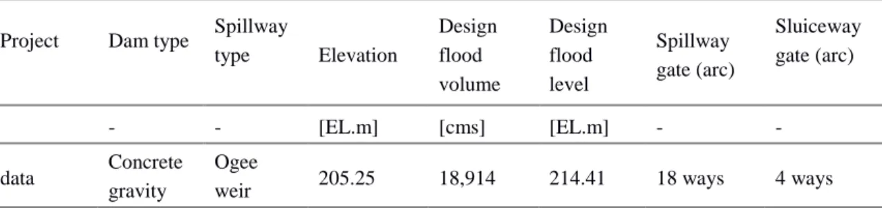
Jiji Weir is located at the Lin-Wei Mountain pass on the mid-stream of Jhuo-shui River, with its full length at 352.5 meters and height at 15 meters. On the top of dike, 18 water sluice gates (height at 10 meters, width at 15 meters) and 4 sluiceways were built, while one large water intake and settling basin on both banks of the dike were constructed, as well as one fishway on the side of the water intake at the south bank (Table 1, Figure 1). The water supply targets of the Jiji Joint Flume Engineering Project include about 100,000 hectares of agricultural irrigation water use in the Chang-Yun area, domestic water use of the Yunlin area, the industrial water use for the industrial area in the offshore islands, and the non-consumptive water use for Mingjian hydropower plant. [2]
Table 1 Basic information of Jiji Weir
Project Dam type Spillway
type Elevation Design flood volume Design flood level Spillway gate (arc) Sluiceway gate (arc) - - [EL.m] [cms] [EL.m] - - data Concrete gravity dam Ogee
An Overlook of Jiji Weir
Standard Section of Spillway
Standard Section of sluiceway
Figure 1 Basic information of Jiji Weir
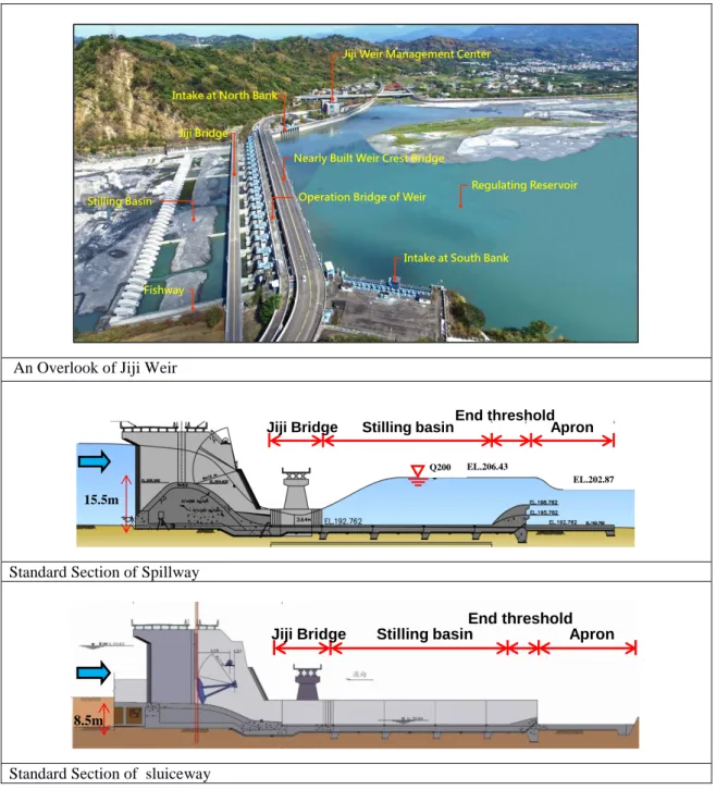
The highest water volume in the Jhuo-shui River was 7.71 billion cubic meters in 2008, the lowest was 1.782 billion cubic meters in 2000, with an average of 4.562 billion cubic meters. The flow dispersion is quite high (Figure 2) [2], and the drought and wet flow varies greatly. This phenomenon will lead to an increase in the stable water supply pressure. The operation of the Jiji Weir has been affected by the extremely high and low discharge for 16 years, and the average annual sediment discharge is about 199 million tons, making the stability of the water supply, the operation and maintenance of the facilities all severely tested.
Jiji Bridge
Stilling Basin
Fishway
Intake at North Bank
Operation Bridge of Weir
Jiji Weir Management Center
Intake at South Bank Nearly Built Weir Crest Bridge
Regulating Reservoir
15.5m
Jiji Bridge Stilling basinEnd thresholdApron EL.206.43
EL.202.87 Q200
8.5m
Jiji Bridge Stilling basin Apron
Figure 2 Annual Discharge of Jiji Weir
Jiji Weir has been officially begun operation since 2002. The design water storage capacity is 10.05 million tons. It was hit by the Typhoon Toraji in 2001 which carried a large amount of muddy sand, causing about 4 million cubic meters of siltation of the storage area, close to the final equilibrium state of the siltation of the reservoir, that is, the apex of the sedimentary delta has reached the front of the spillway. In addition, the initial operation in 2002 and 2003 suffered an extraordinary dry year, with an annual inflow of only 1.782 billion tons and 1.887 billion tons, which has been the secondly and thirdly low inflow of the Jiji Weir for 60 years from 1959 to 2018. Therefore, under the condition of raising the water level to storage water, the sediment deposition volume in the water storage area was about 5.19 million tons. The effective storage capacity is only 4.86 million tons. (Table 2) [4]
Table 2 Annual Effective Storage Capacity Date Effective Storage
Capacity
Max. Discharge Current Year Vol.
Current Year Dredging [million m3] [cms] [billion m3] [million m3] Original Plan 10.05 Oct. 2003 4.86 2,269 1.887 - Oct. 2004 7.01 6,500 4.420 0.960 Oct. 2006 5.84 5,143 6.286 - Nov. 2008 4.61 10,865 7.710 0.350 Oct. 2010 4.25 2,379 2.762 0.460 Dec. 2012 4.98 10,605 6.969 - Dec. 2014 5.01 4,980 3.152 0.600 Dec. 2016 5.15 3,154 4.766 0.110 Nov. 2018 4.41 3,284 3.079 0.108
2 Current Challenge of Jiji Weir
Jiji Weir is located at the Lin-Wei Mountain pass. Since the upstream river width of the Jilu Bridge is about 1 km, and the width of the Jiji Weir is only 352.5 meters, gathering water from both sides, forming two streams of water, the siltation of the water storage area is concentrated in the central area. Therefore, it is less able to exclude the silt in the central area by the hydraulic slag removal.
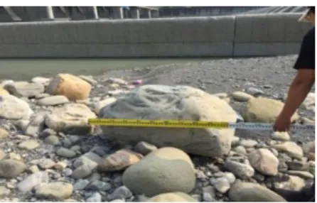
Jiji Weir is an onstream reservoir, hence it mainly uses hydraulic slag removal to remove the slag. Meanwhile, the Jhuo-shui River is a river with large amount of sediment, causing the severe wear pattern on the weir body when the mud and sand passing through and crashing the surface. Especially during floods, the spillway and the sluiceway will be more obviously worn and torn. Therefore, the challenge of wear pattern and maintenance strategy still need to be continuously discussed. (Figure 3)
Large rocks at upstream of the weir The rock staying in the stilling basin after flood.
Wear pattern of the spillway
Wear pattern of the sluiceway
Figure 3 The rock staying in the stilling basin after flood and wear pattern of the spillway and sluiceway
3 Maintenance and Monitoring of the Wear Pattern on the Weir
Surface
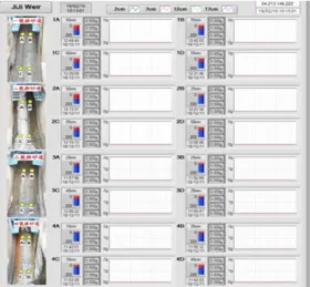
The Jiji Weir Management Center has been monitoring the surface wear pattern of the sluiceway. Besides the traditional total station theodolite method measurement, as long as the desilting operation is performed, the weir surface elevation is measured. However, this method could only be used for post-event monitoring. In recent years, the monitoring method has been improved to the immediate wear monitoring system. With the repair of the weir surface, the electronic sensing device is embedded beneath the surface of sluiceway, with the consistent length and restored thickness of 20 cm. If the weir surface is worn out, the embedded electronic sensing device will break the circuit, which could be immediately transmitted to the manager's computer system and presented as a web page (Figure 4), so that the manager could know the wear and tear pattern of the weir surface at the first time.
Figure 4 The immediate wear monitoring system of the sluiceway wear pattern, which could be used to remotely monitor the wear pattern on the surface of the sluiceway.
4 Storage Capacity Maintenance Strategy
The characteristics of the Jiji Weir are mainly to maintain a water level of a stable water supply, which is different from the operation model of a general reservoir with larger storage capacity to store water in the wet season and supply water in the dry season. Therefore, in the case of siltation in the water storage range, as long as the sluiceway is opened to remove the silt accumulated in front of the water inlet, the water supply will not be affected. During the flood period, in addition to a small amount of water supply for domestic and industrial water use, the spillway will be opened for hydraulic slag removal, and silt in the water storage range will be desilted as much as possible.
In the hydraulic slag removal model, it has been continuously explored in recent years that in the "Regulations on the Operation of the Sluice Gate of the Jiji Weir", it is necessary to fully open the spillway when the inflow rate is above 1,300 cms, while the inflow rate is below 1,300 cms, it is still being explored that if there is an optimum way of sluice opening sequence to remove silt, referred to "The research of depositing and discharging sand operation in Chi-chi weir" (2005) [1]. According to the results of desilting operation, the flood can effectively desilt up to 200 meters (about 283.88 meters) from the weir to the upstream river. There is no severe siltation between 200 meters and 1,000 meters upstream. In order to clear the water storage, the sediment of right bank with higher concentration is discharged, and there is a better desilting effect at the sluice of the left bank (No. 13~18) (Figure 5). The area located from about 1,082 meters upstream of the weir to the Jilu Bridge relies on manual dredging. Therefore, the management center is currently using manual dredging to make a dredging waterway in dry seasons, and use it to dredge in wet seasons by hydraulic slag removal. At present, the dredging work is mainly carried out in the central area, and the target is to direct the water flow to the higher siltation in central area by hydraulic slag removal during the flood period. In recent years, continuous attempts have been made, and the silt that can be removed by the sluice is only about 200 meters upstream of the weir, with limited effects. Therefore, the management center conducts the silt removal work in combination with the manual dredging and directing water flow using the hydraulic slag removal method.
Simulating the suspension load concentration when the right sluice is closed at a flow rate of 1,000 cms.
when the left sluice is closed at a flow rate of 1,000 cms
Figure 5 Simulating the suspension load concentration, whcih shows that closing the left sluice and opening the right sluice would dredge the higher concentration sediment at the right bank.
225200 225700 x (m) 2634300 2634800 2635300 y (m ) 10 500 1000 2000 3000 5000 10000 (ppm) 225200 225700 x (m) 2634300 2634800 2635300 y (m ) 10 500 1000 2000 3000 5000 10000 (ppm)
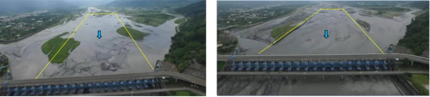
In 2015, the management center removed the silt about 2 meters of thickness in the central area from about 1,000 meters upstream of the river to the Jilu Bridge, so that the main waterway could be directed to the central area as much as possible. After the flood in 2016, through the method of fully opening spillway to discharge the silt, the silt in the water storage range was largely eliminated, and the maximum effect of manual dredging combined with hydraulic slag removal is initially achieved (Figure 6). However, after the water level is raised in the dry season, the original equilibrium siltation will be restored.
Aerial View on Jun. 16, 2016 Aerial View on Sep. 29, 2016
Figure 6 It shows that the silt in the central area has been clearly dredged by comparing the results of hydraulic slag removal.
5 Conclusions
The Jiji Weir is located at the Lin-Wei Mountain pass of the Jhuo-shui River, which is characterized by large flow velocity, easy sedimentation in the upstream and easy to be worn and torn on the weir surface. In recent years, continuous attempts and efforts have been made to conduct research and discussion. Manual dredge with directing waterways and hydraulic slag removal in the water storage range is preferred sand discharging models. Better maintenance frequency and model of the wear and tear on the weir surface is gradually developed. Under the continuous efforts of the management center, the overall water supply operation is stable and safe. However, extreme hydrological events have frequently happened recently, resulting in a decrease in water diversion and affecting the safety of facilities. Therefore, it is still necessary to continue to improve the performance of water supply and related sluice operations in order to adjust the evolution of long-term hydrological conditions.
6 References
1.Central Region Water Resources Office, Water Resources Agency, Ministry of Economic Affairs. (2005). The research of depositing and discharging sand operation in Chi-Chi weir
2.Central Region Water Resources Office, Water Resources Agency, Ministry of Economic Affairs. (2018) Ji-Ji Weir in 2018 Water Resources Allocation and Gate Operation Report
3.Central Region Water Resources Office, Water Resources Agency, Ministry of Economic Affairs. (2014) Best Modell for Operation of Ji-Ji Weir