Sediment management at the river-basin
scale: challenges and opportunities
G Mathias Kondolf
Abstract
Sediment loads are best understood and managed at the river basin scale. This is rarely done, but such a strategic approach can optimize reservoir sustainability, habitat conditions in downstream channels, and persistence of coastal landforms.
Keywords: sustainable sediment management, morphogenic flows, gravel augmentation, strategic dam planning
1 Introduction
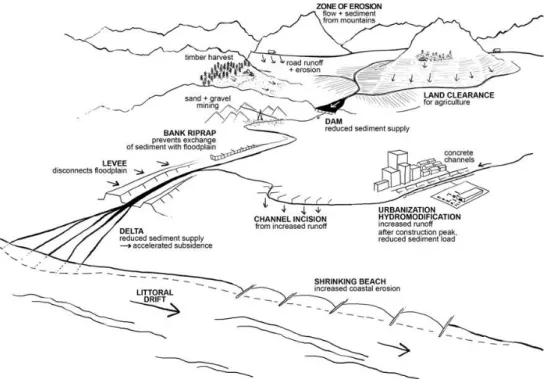
Sediment issues are most commonly acknowledged at the local scale (eg, of river reaches), without understanding basin-scale connections. However, the sediment load at any given point is influenced by factors such as increased erosion and sediment yield from removal of native vegetation, road construction, and other land disturbance, especially in steep upland areas, as well as urbanization and resulting increased runoff and channel incision (Figure 1). Sediment transport through the river network can be interrupted by natural and artificial means, including mining of sand and gravel from river channels, and trapping behind dams. Despite widespread land disturbance and increased sediment yields from upland areas, the sediment loads of most major rivers have decreased in recent decades from trapping of sediment by dams (Walling 2006), increasingly manifest in accelerated coastal erosion and delta loss (Syvitski et al. 2009).
2 Challenges of sediment trapping by dams
Dams typically store water by design, and store sediment as an unintended consequence, although some dams have been built as debris basins or sediment-control (sabo) dams (Wang and Kondolf 2013). Dam-induced changes in flow regime are typically accompanied by reductions in the river’s sediment load as reservoirs trap 100% of the river’s bedload (the coarse sediment that moves along the channel bed by rolling, sliding, and bouncing, consisting of gravel and sand), and a percentage of the suspended load (sand, silt, and mud held aloft in the water column by turbulence), which depends on the ratio of the reservoir storage capacity divided by the mean annual inflow of water. Changes in flow and sediment load downstream of damsalmost always produce changes in alluvial channel form (e.g. incision, narrowing) and bed material composition (e.g., clogging, armoring) (Kondolf 1997).
Figure 1. Human alterations increasing sediment yields from the upland landscape, sediment trapping above dams, and consequences of sediment starvation downstream. (from Kondolf and Podolak 2013)
Reservoirs that trap sediment but still release flows that are high enough to transport sediment create sediment-starved, or ‘hungry water’ downstream, so-called because these flows still have energy to transport sediment, but their sediment loads have been taken away by trapping in the reservoir, and thus they possess energy far in excess of their actual sediment loads (Kondolf 1997). This excess energy is expended on bed and bank erosion, leading to channel incision (downcutting) and consequent undermining of bridges and other infrastructure and loss of habitats through channel simplification. However, hungry water does not occur downstream of all dams. It depends on the balance of flows and sediment supply. Reservoirs with large storage (relative to flow in the river), built to redistribute water between seasons or even years, commonly reduce high flows, reducing the dynamism of the river channel downstream. Gravel beds formerly mobilized every year or two may go for years without being moved, allowing fine sediments to accumulate withn the gravel and riparian vegetation to establish in the active channel. The reduced flow may not transport sediment delivered to the river by tributaries below the dam, promoting channel aggradation. Thus, depending on the balance between transport energy available and sediment supply, river reaches below dams may be in sediment deficit or surplus (Schmidt and Wilcock 2008).
The complexity of alluvial channel forms depends upon the availability of coarse sediment (sand and gravel) that compose bars and riffles. In reaches starved of sediment by upstream dams, gravels are transported downstream without being replaced, resulting in loss of bars and riffles, and thus loss of channel complexity and habitats needed by fish
and invertebrates. Similar to river channels, coastal morphology results from a balance between coastal erosion and sediment supply from rivers. Where the sediment supply to coasts and deltas has been cut off by upstream dams (and/or other activities such as in-channel mining), coastal lands have eroded back and subsided below sea level at increasing rates, as documented for the Mississippi (Blum and Roberts 2009) and the Mekong (Kondolf et al. 2018, Schmitt et al., 2017). For example, the delta of the Mekong River was created by deposition of abundant river sediments, as the coast built out more than 250 km over the past 7,000 years, from the current location of Phnom Penh to its present configuration. After millenia of progradation, however, the delta has begun retreating in the last two decades (due to factors such as in-channel mining of sand and accelerated subsidence) (Kondolf et al. 2018).
3 Opportunities to restore sediment load below dams
To mitigate dam-induced impacts on sediment and channel processes, controlled high-flow releases designed to mimic the action of natural floods (morphogenic high-flows, Kondolf et al. 2019) are increasingly required in hydroelectric licenses for dams and as part of programs to restore river function. However, even if a post-dam flow regime were to mimic precisely the pre-dam flow regime, the river system would be severely altered by the loss of its sediment load (Kondolf and Wilcock 1996, Wohl et al 2015). Thus, it is essential to account for sediment supply downstream of dams from tributaries (e.g., Grams et al, 2013), and partial restoration of sediment load is often prescribed along with morphogenic flows (Kondolf, 1997; Tena et al. 2012).
To partially restore sediment load in a regulated stream, coarse sediments are most commonly added to downstream channels by mechanical means. In some cases, sediment has been mechanically removed from reservoir deltas and placed in the downstream channel to augment sediment supply (Jones and Stokes, 2003; Kantoush and Sumi, 2010),
but this is rarely done because of cost and logistical/legal impediments to dredging the deltas and transporting the sediments around the reservoir and dam. Most sediment mechanically added downstream of dams derives from terrace or floodplain gravel pits. Such gravel augmentation or gravel replenishment has been widely undertaken in North America and Europe, usually to restore spawning habitat for salmon or trout. On the Trinity River, California, these efforts have evolved over the past four decades from creating artificial riffles, to releases of morphogenic flows coordinated with gravel augmentation (Wilcock et al. 1996), to the current goal to build bars and complex channel habitat by adding coarse sediment and releasing morphogenic flows (Gaeuman 2014). Resulting ecological benefits include processing particulate organic matter, inducing hyporheic exchange, and creating thermal complexity (Ock et al. 2015).
On the Uda River below the Murou Dam, Japan, sediment replenishment has been undertaken to restore sediment transport and channel complexity since 2006. In the first five years of the restoration program, natural flows spilling from the dam were sufficient to transport the added sediment, but in the subsequent four years, morphogenic flows
were released to achieve desired sediment mobility (Kantoush and Sumi 2011). Increasingly, sediments are added to reaches below dams in Japan to support development of gravel bars and other complex channel features (Ock et al 2013). Dams vary widely in their settings (flow, sediment load, presence of tributaries downstream, channel slope, etc), in their size relative to the river flow, and in their design and operation (size and location of outlets, reservoir geometry, etc.). A sediment budget provides a framework to assess dam-induced disruptions to the sediment balance and to specify morphogenic flows and replenishment of sediment to downstream reaches.
More cost effective than mechanically adding sediment downstream of dams is to employ gravity to pass sediment through or around small dams, employing a range of techniques (Annandale et al. 2016, Kondolf et al. 2014b). A sediment bypass can divert part of the incoming sediment-laden waters into a tunnel around the reservoir, so they never enter the reservoir at all, but rejoin the river below the dam. Sediment can also be sluiced by maintaining sufficient velocities through the reservoir to let it pass through without allowing it to deposit. Alternately, the reservoir can be drawn down through low-level gates to scour and re-suspend sediment in the reservoir and transport it downstream. Density currents can be passed b y o p e n i n g bottom outlets to allow the higher-density, sediment-laden waterto pass through the reservoir intact. Sluicing, flushing, and density current venting pass sediments in suspension, which tend to be the finer fractions of the sediment load but can include significant sand. Sluicing and flushing work best on reservoirs that are narrow, have steep channel gradients, and have storage that is small relative to the river flow. Otherwise, back-water zones might form in wider reservoirs where the hydrodynamic forces are insufficient to mobilize sediment. Flushing has been effective on reservoirs that impound less than 4% of the mean annual inflow (Sumi 2008). Large reservoirs with year-to-year carry-over storage are poor candidates for such sediment pass-through approaches. Another approach is to divert water to an off-channel reservoir only during lower flows, when water is relatively sediment free, while allowing sediment- laden floodwaters to pass by in the main river.
It is most efficient to take sediment management into account at the outset of the design and planning the operation of dams, so that dams are equipped from the outset to successfully sluice or slush sediments (e.g., with sufficiently large low-level outlets), and the operations are planned to account for some periods of reduced power generation (or other functions) to allow sediment to be passed. Retrofits to allow sediment passing through existing dams may be possible, but often raise safety concerns. Bypasses can be safely built around existing dams without threatening the integrity of the dam.
4. Opportunities to minimize sediment trapping through strategic dam planning Strategic dam planning at the river basin scale is an often-overlooked opportunity to minimize sediment trapping in dams, with benefits for the dam infrastructure and the
downstream rivers and coasts. Such planning should involve recognizing the spatial heterogeneity in natural sediment transport, cumulative effects on sediment supply of multiple dams in a river network and consequent geomorphic impacts (e.g., Kondolf et al. 2014a). New dams should be located so the dam portfolio minimizes disruption of sediment transport (Schmitt et al. 2018), and each individual dam should be designed to maximize its ability to pass sediment around or through reservoirs.
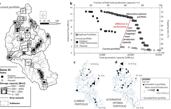
Figure 2. Power generation and sediment trapping from dam building in the Sre Pok, Se San, and Se Kong rivers (the ‘3S basin’), the largest downstream tributary to the Mekong River (drainage area 80,000 km2). (a) The current 3S dam portfolio includes 21 dams built or under construction, and 21 more at various planning stages. (b) Increased power generation capacity and cumulative sediment trapping with construction of the current dam portfolio (black squares for existing dams, white diamonds for planned dams) and alternative portfolios with an optimal trade-off between sediment trapping and power production (grey circles). The arrow indicates a dam portfolio with higher power production but lower sediment trapping compared to the current portfolio (see arrow). Optimal portfolios were identified based on analysis of 17,000 alternative dam portfolios. The optimal portfolio compares favorably to the currently planned development because of a different spatial configuration of dams in the network. (c) The current dam portfolio includes dams downstream in the Sre Pok and Se San. (d) The alternative, optimal portfolio relies more on dams in the headwaters and on lower sediment-yield portions of the basin, and also produces higher economic benefits. (adapted from Schmitt and Kondolf 2017)
As demonstrated for the major downstream tributary of the Mekong River (the Sre Pok, Se San, and Se Kong system), strategic dam planning could have resulted in a dam portfolio producing 68% of the basin’s hydroelectric power potential while trapping only
21% of its sand load. The actual portfolio built to date is the result of project-by-project construction of dams, without a strategic trade-off analysis or planning (Figure 2). As a result, the current dam portfolio produces 51% of the basin’s hydroelectric capacity while trapping 91% of its sand load, mostly because of early construction of downstream dams in the Sre Pok and Se San basins (Figure 2) (Schmitt et al. 2018) with high sediment trapping and very little potential for sustainable sediment management. The Mekong example demonsrates the advantages of strategic planning (with careful, basin-scale assessments of dam impacts and benefits) over the current ad-hoc development of individual dams.
5 Conclusions
Maintaining habitat downstream of dams can involve a combination of morphogenic flows and sediment augmentation. Especially when planning new dams, decision makers should be aware that such measures will require continuous investments to provide lasting improvements. For very large rivers, such as the Mekong, cumulative dam sediment trapping and the related impacts on the river system might well exceed what can be possibly mitigated with such approaches. Where mitigation measures are feasible, a simple sediment budget and assessment of geomorphic processes and habitat conditions should be conducted before undertaking restoration actions, comparing downstream sediment supply with energy available to transport it, to ascertain if the reach has a sediment deficit or surplus, and to what degree. Likewise, assessing post-dam channel adjustments and their implications for aquatic habitat will inform potential options for restoration
References
Annandale, G.W., Morris, G.L., & Karki, P. 2016. Extending the Life of Reservoirs: Sustainable Sediment Management for Dams and Run-of-River Hydropower, Washington, DC, The World Bank Group.
Blum, MD, and H Roberts. 2009. Drowning of the Mississippi Delta due to insufficient sediment supply and global sea-level rise. Nature Geoscience 2:488-491.
Gaeuman, D. 2014. High-flow gravel injection for constructing designed in-channel features. River Research and Applications, 30, 685–706.
Jones & Stokes. 2003. Water quality and aquatic resources monitoring program for the Ralston Afterbay sediment management project – 2002 annual report, Report to Placer County Water Agency by Jones & Stokes, Sacramento, Calif., 26 pp plus tables, figures, and appendices.
Kantoush, S. A., & Sumi, T. 2010. River morphology and sediment management strategies for sustainable reservoir in Japan and European Alps, Annuals of Disaster
Kantoush, S.A., & Sumi, T.. 2011. Sediment replenishing measures for revitalization of Japanese rivers below dams. pp. 2838-2846 in Proceedings of the 34th IAHR World Congress, Brisbane, July 2011.
Kondolf, G.M. 1997. Hungry water: Effects of dams and gravel mining on river channels. Environmental Management, 21(4), 533-551.
Kondolf, G.M., and K. Podolak. 2013. Space and time scales in human-landscape systems. Environmental Management DOI 10.1007/s00267-013-0078-9
Kondolf, G.M., & Wilcock, P.R. 1996. The flushing flow problem: Defining and evaluating objectives. Water Resources Research, 32(8):2589-2599.
Kondolf, G.M., Z.K. Rubin, J.T. Minear. 2014a. Dams on the Mekong: Cumulative sediment starvation. Water Resources Research 50, doi:10.1002/2013WR014651. Kondolf, G.M., Gao, Y., Annandale, G.W., Morris, G.L., Jiang, E., Hotchkiss, R., Carling, P., Wu, B., Zhang, J., Peteuil, C., Wang, H-W., Yongtao, C., Fu, K., Guo, Q., Sumi, T., Wang, Z., Wei, Z., Wu, C., & Yang, C.T. 2014b. Sustainable sediment management in reservoirs and regulated rivers: experiences from five continents. Earth’s Future doi: 10.1002/eft2 2013EF000184 Online at
http://onlinelibrary.wiley.com/doi/10.1002/2013EF000184/pdf
Kondolf, GM, R Loire, H Piegay, and JR Malavoi. 2019. Dams and channel
morphology. Chapter 8 in Environmental Flow Assessment: methods and applications, JG Williams, PB Moyle, A Webb, and GM Kondolf (eds), John Wiley & Sons.
Kondolf, GM, RJP Schmitt, P Carling, S Darby, M Arias, S Bizzi, A Castelletti, T Cochrane, S Gibson, M Kummu, C Oeurng, Z Rubin, and T Wild. 2018. Changing sediment budget of the Mekong: Cumulative threats and management strategies for a large river basin. Science of the Total Environment 625: 114-134.
https://doi.org/10.1016/j.scitotenv.2017.11.361
Ock, G., Sumi, T., & Takemon, Y. 2013. Sediment replenishment to downstream reaches below dams: implementation perspectives. Hydrological Research Letters 7(3): 54-59.
Ock, G., Gaeuman, D., McSloy, J., and Kondolf, G.M.. 2015. Ecological functions of restored gravel bars, the Trinity River, California. Ecological Engineering 83:49-60. Schmidt, J. C., & Wilcock, P. R. 2008. Metrics for assessing the downstream effects of dams, Water Resources Research, 44, W04404, doi:10.1029/2006WR005092
Schmitt, R.J.P., Rubin, Z., Kondolf, G.M., 2017. Losing ground - scenarios of land loss as consequence of shifting sediment budgets in the Mekong Delta. Geomorphology.
Schmitt, R.J.P., Bizzi, S., Castelletti, A., & Kondolf, G.M. 2018. Improved trade-offs of hydropower and sand connectivity by strategic dam planning in the Mekong. Nature Sustainability, 1, 96–104.
Sumi, T. 2008. Evaluation of efficiency of reservoir sediment flushing in Kurobe River, pp. 608–613,in 4th International Conference on Scour and Erosion, Tokyo, Japan.
Syvitski, J.P.M., Kettner, A.J., Overeem, I., Hutton, E.W.H., Hannon, M.T.,
Brakenridge, G.R., Day, J., Vörösmarty, C., Saito, Y., Giosan, L., Nicholls, R.J., 2009. Sinking deltas due to human activities. Nat. Geosci. 2, 681–686. doi:10.1038/ngeo629 Tena, A., Batalla, R. J., & Vericat, D. 2012. Reach-scale suspended sediment balance
downstream from dams in a large Mediterranean river. Hydrological Sciences Journal, 57(5), 831–849.
Walling, DE. 2006. Human impact on land–ocean sediment transfer by the world's rivers. Geomorphology 79: 192-216.
Wang, H-W., & Kondolf, G.M.. 2013. Upstream sediment-control dams: five decades of experience in the rapidly-eroding Dahan River Basin, Taiwan, Journal of the American Water Resources Association, DOI: 10.1111/jawr.12141
Wilcock, P. R., Kondolf, G. M., Matthews, W. V. G., & Barta, A. F. 1996. Specification of sediment maintenance flows for a large gravel-bed river. Water Resources Research, 32(9), 2911–2921.
Wohl, E., Bledsoe, B.P., Jacobson, R.B., Poff, N.L., Rathburn, S.L., Walters, D.M., & Wilcox, A.C.. 2015. The natural sediment regime in rivers: broadening the foundation for ecosystem management. Bioscience, 65(4), 358-371.
Authors
G Mathias Kondolf (corresponding Author)
Dept Landscape Architecture & Environmental Planning
UC Berkeley, 202 Wurster Hall, Berkeley, California 94720. USA Email: kondolf@bekeley.edu