The potential of virtual reality modeling language [VRML] with digital photogrammetric modeling for virtual environments
9
0
0
全文
(2) 1. Introduction World wide web (WWW) on the three-dimensional visualization have implemented a wide variety of computer techniques in order to design, model and simulate the outcome of a given design process or development [1]. Based on the computer visual simulation, designer and developer can easily experience and evaluate the quality space or built environment that have employed the physical environment before. Meanwhile, computerized environmental models are used as a platform for representation and education [2], and they are more helpful to understand the interactions among environmental experience, attributes and characters [3]. Within these issues, VRML on the world wide web (WWW) have been created with several aims: to aid the design process, to represent the environmental information and to argument virtual reality. For digital photogrammetry, surveying methods based on image and photographic are used in many applications in computer graphics, computer game and industrial metrology. As photogrammetry generally records all data as a series of dimensional coordinates, it makes a good tool and application partner for today’s three-dimensional computer graphic design and virtual reality. Photogrammetry basically means measuring in images. Therefore a system for digital photogrammetry must be a hybrid, processing both image and vector data. In monument preservation or archaeology it can be used to produce very detailed documentations which can be used as reference to judge the spatial issues. On the other hand, the production of rectified texturemaps from perspective image applies the representation of virtual reality. For computer graphics application, digital photogrammetry is an interesting topics for computer aided architectural design and create a modeling strategy quite different from the current CAAD system. This paper explores the process of computer aided architectural design in computer visual simulation on the Web. It also provides a digital way to experience the physical environment and examine the reality space with visual hierarchy that from near to far are gravity, direction, weather character, buildings element and urban scale. On the other hand, Lynch’s [3] notions on the elements of urban image, such as paths, edges, districts, nodes and landmark, was reviewed with virtual cityscape to disciplines of urban design. Having outlined these potentials, the ability of the Web to serve as a dissemination mechanism will be discussed. 2.. Managing data. 2.1. Data transformation in CAAD. The major work of architectural visualization currently pursuit the several issues which are the characters of the traditional urban feature, different periods of urban development, the identities of street , the amenity of outdoor space, the environment of neighborhood, and the promenade of spatial procedure. For transforming data of these fields, information, data and spatial prototype have to become structure and digital format. Furthermore, for representing and communicating on the same channel, the schemes of architectural design need to provide a model with interactive tools to evaluate of planning information. By these proposals, a large volume of information has to transform as the useful data or database based on a distributed platform to store and convert them to digital format. And all of data are built upon the application of.
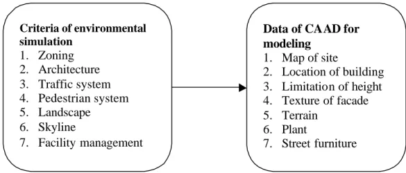
(3) Internet (Fig. 1). Follo wing this procedure, we start to collect text, graphics, images and maps in order to approach digital modeling of architectural design schemes. Issues of architectural visualization 1. the characters of the traditional urban feature 2. different periods of urban development 3. the identities of street 4. 5. 6.. the amenity of outdoor space the environment of neighborhood. Tools of Transformation 1. Scanners 2. Cameras 3. Photogrammetry 4. Software of CAD 5. Laser scanners 6. 3D digitizers. the promenade of spatial procedure. Digital Data Format 2D DataUnicode of text 2D DataRaster image 2D DataVector image 3D DataComputer modeling 4D DataComputer animation 4D DataMultimedia. Figure 1. The process of data transformation 2.2 A digital integration The main purpose of simulation is to represent physical environment as new feature. For integrated with traditional heritages and urban environment, the provision of information should clearly deliver the actual definition of database. It is critical to build an appropriate data structure to store or restore the characters and attribute of information, as shown in Fig. 2. On the other hand, for the accurate perception of simulation, different data can be applied the model of various level of scale. Therefore, a larger scale map with an abstract view is not only simulating appropriate image but also speeding Internet application.. Criteria of environmental simulation. 1. 2. 3. 4. 5. 6. 7.. Zoning Architecture Traffic system Pedestrian system Landscape Skyline Facility management. Data of CAAD for modeling 1. Map of site 2. Location of building 3. Limitation of height 4. Texture of facade 5. Terrain 6. Plant 7. Street furniture. Figure 2. Relationship between criteria of urban design and data of CAAD for modeling. 3.. The methods of modeling.
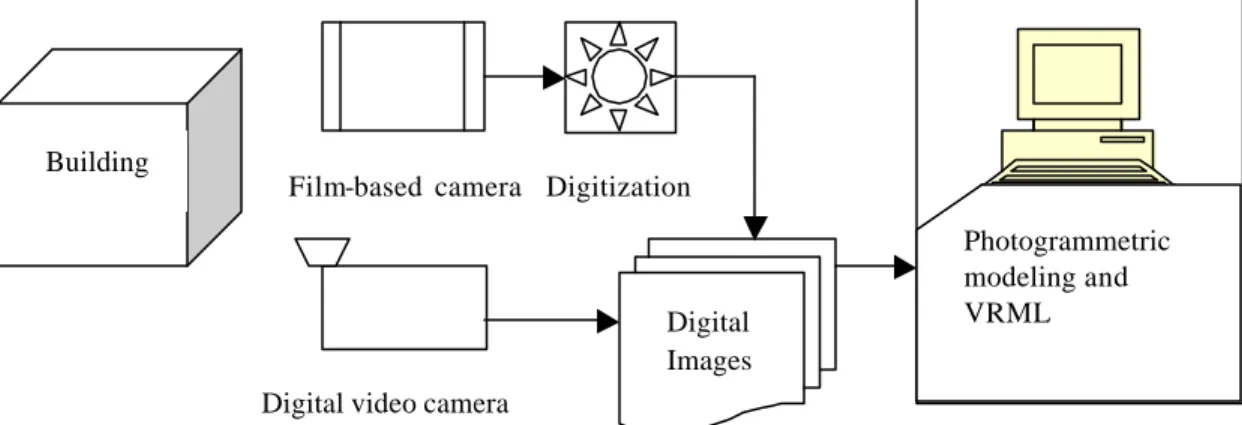
(4) 3.1. Modeling of VRML. VRML is a programming language to present 3D graphics on the World Wide Web (WWW). It’s viewer (cortona) which was used as VRML browser (ParallelGraphics inc.) with Internet Explorer (Microsoft Inc.) provide interactive functions for exploring existing models. Indeed, VRML language was designed as an open source for integrating 3D virtual worlds into the Internet. VRML provides a flexible, cross-platform (VRML is viewable on any internet system with the appropriate browser) environment to model geometry form, the user is able to producing a model using a popular 3D software such as 3d Studio MAX or FormZ. As VRML data file is designed for distribution on the WWW, the volume has to reduce as small as possible. On the other hand, for realism purposes, VRML modelers are sometimes have to apply textures, or photorealistic facades to the VRML objects in order to increasing model “reality”. The more powerful PC and the faster transit of Internet permit the performance and speed of virtual reality. The current release of VRML (VRML 2.0) allows the modelers to increase the level of achievable realism by permitting behaviors to be assigned to objects. Behaviors allow a scene to include objects with movement and directional sound, significantly increasing levels of details, surface normal and interactivity [3]. 3.2. Modeling and measuring by digital photogrammetry. The first step in a photogrammetric process is the acquisition of image data (see fig.3). Traditional film-based cameras still provide good image resolution, today’s digital video camera offers a number of advantages which are quality and quantity control, no subsequent digitization and argument post-producing to animation. On the other hand, Image-based modeling requires the input pictures as much as possible to build the 3D geometry. The model must fit perfectly each image in order to achieve the best results, especially when generating textures. After calibration, normally you place more points to the images to build a cloud of point that will serve as the basis for creating the polygonal mesh. Of course, the more points placed, the more precise model will be. Currently this semi-automatic measurement techniques create a need for a modeling strategy which is different from traditional method in computer aided architectural design. There are some software processing the 2d raster image to 3d vector computer graphy which are Photomodeler(Eos Systems Inc.) and Imagemodeler (REALVIZ Inc.).. Building. Film-based camera Digitization. Digital Images. Photogrammetric modeling and VRML. Digital video camera. Figure 3. Process overview for digital photogrammetric modeling.
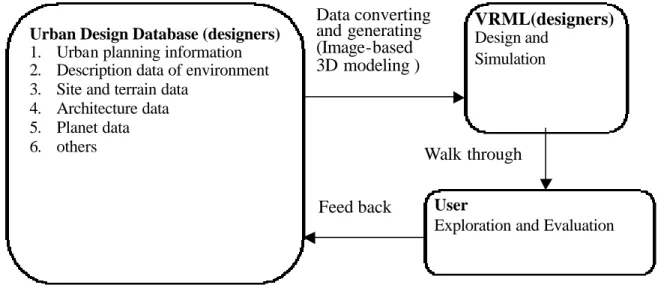
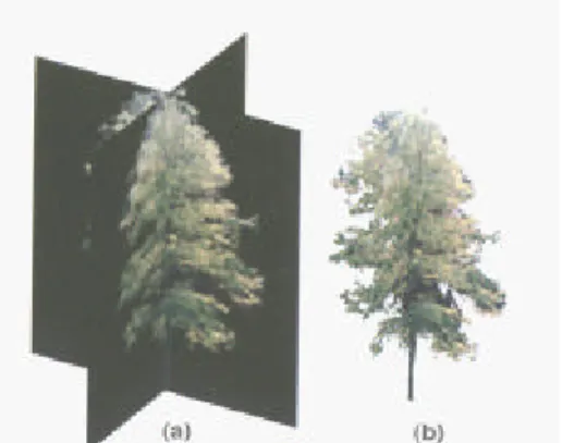
(5) 3.2 The digital modeling of VRML on general physical environment This section will explore the process of digital modeling in physical environment. VRML, 3D graphic technology, is currently developed for Web-based dissemination. As a part of this research, this process has been examined in four major steps of Web-based development, shown as Fig. 4: (1) Planning database implementation; (2) 3D Solid modeling; (3) VRML generator (Web data file); (4) View VRML model (plug- in “browser”); Stage1 Planning database implementation. Stage 2 3D solid modeling. Stage3 VRML generator (Web data file). Stage4 View VRML model (plug- in “browser”). Figure 4. The four stages of creating virtual world Basic functions for the simulation of environment are the modeling of representation that based on the environment of city, site, architecture and plants in the real world. With these aspects, the process of the simulation using VRML is shown as Fig. 5.. Urban Design Database (designers) 1. Urban planning information 2. Description data of environment 3. Site and terrain data 4. Architecture data 5. Planet data 6. others. Data converting and generating (Image-based 3D modeling ). VRML(designers) Design and Simulation. Walk through Feed back. User Exploration and Evaluation. Figure 5. The process of environment simulation by VRML. 3.4. Image-based modelings ( plants and background). For the rendering purpose , the model of plants are formatted to 2D texture TGA data files as crossed way modeling, shown as Fig. 6. This method is an efficient modeling for fast rendering the virtual plants. By mapping the texture on the model, the quality of the element in urban environme nt is improved that approach closely to the purpose of virtual reality. Following the texture mapping, the background of environment is potentially enhanced on the modeling process. Generally the background was dealing with the.
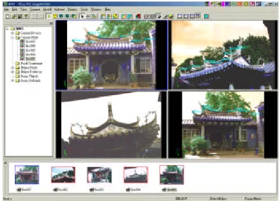
(6) fog to blur the depth of focus. On the case of large scale model, it might make a huge VRML file to consume the time for download. For above problem, by modeling the surface as a background around the site with seamless texture mapping, file size of VRML could reduce efficiently, shown as Fig. 7. This producing way of modeling is different from 360o panoramic image applied on the VR environment.. Figure 6. 2D texture data files as crossed way modeling. Figure 7. Seamless texture mapping as background. 4. Discussions 4.1 Results of visualization For the reason of scale, digital models have to be classified to present the proximate detail. By analyzing four scale of urban rendering, the view of block scale reveals an appropriate vista point to review the landmark and nodes, shown as Fig. 8. With detail of architecture, plants and elements of street furnish, the VRML images are qualified by comparing with real-photo to evaluate the ability of simulation. In reality, quality of the VRML performance was critical about the issue of accuracy. In order to represent the image of impression, the data for visualization have to undertake accuracy of coordinates, geometry and scale of buildings. Furthermore, the database of image with various timelines and periods provided historical study which will address another issues of virtual preservation of building.. Figure 8. The visualization of landmark (Taipei City Hall) and neighborhood on VRML browser. 4.2 Interactive function of VRML system.
(7) VRML browser provides several ways of view: walk, fly, plan, pan and turn. With these tools of view, we can study the vista point and path for animation of walk through (Fig. 9.). Some proposals of environment design required the control of viewpoint. VRML program has the function of pre-defined viewpoint and its browser provides the tools to find it easily. Different promenade of walk-through represent the possible outlooks of urban design. For experiencing the sequence of images, VRML program provide the function of “navigationinfo node” to limit highlight, speed and visibility. In fact, there is a lot of advanced nodes which enhance the interactive functions in the VRML world.. Figure 9. Images of walk through (left to right)(the streetscape of Lu-Chu technology industry) 4.3 Modeling with photogrammetric system for measurement The model of defined by photogrammetry is a limited amount of geometric deformability, while maintaining some qualitative aspects of its shape. These constraints can offer the computer’s measuring operations and ensure a qualitatively correct result. Without any qualitative guidance the accuracy of the measurement process creates unexpected results. (shown as fig. 10) Therefore, the parame terization of the individual objects is what we refer to as critical constraints. The shape characteristics that can be controlled with the set of parameters are identical to the ways the photogrammetric procedures can adjust the element to better match the results of the 3D feature extraction. On the other hand, users can get feed back about the reliability of the extracted features by the underlying model. This thought reveals the final aim of photogrammetric modeling which is either to represent reality or to argument reality.. Figure 10 The working model of traditional building on the software (Imagemodeler).
(8) 5.Conclusion The study explored the above implementation of using VRML language, photogrammetric and image-based modeling which proves to be a feasible way for environmental design studies. Computer with the Internet environment provides an interactive interface for people to examine the virtual reality world. In fact, personal computer simulation becomes a affordable and an efficient approach for spatial studies. This paper also provides a digital approach to understand the digital architectural photogrammetry which brings together the functionality of virtual environment and computer measurement procedures. The current integration of the computer visualization and the photogrammetry systems is a potential development of new CAAD modeler, which is designed to reach the special requirements of the photogrammetric computer measurement procedures. For computer visualization, new environment features, and other examples are shown for representing the above points. From the research aspects, the management of image data, geometric modeling, and virtual reality world based on the Internet in the large-scale urban models are examined. The results show that extending the development of WWW beyond the PC standalone theories is critical for future research. The virtual environment of VRML with photogrammetry modeling is a start to integrate the possible applications on the CAAD process. Reference 1.Bell, G. Parsis. A. & Pesce, M (1995) “ VRML.: The virtual reality modeling language, version 1.0 specification. in VR for the people: A brief history of VRML” [Online] Available: http://www.gnn.com/gun/wr/sept29/features/vrml/history.html. 1995 2. A. Day, A. Radford (1995), “Imaging change: the computer city mode as a laboratory for urban design research”, Proc. Of CAAD Future 1995, Singapore, 1995, pp. 495– 506. 3. S. Doyle, M. Dodge and A. Smith (1998), “The potential of web-based mapping and virtual reality technologies for modeling urban environment”, Comput., Environ. And urban systems, Vol. 22, No 2, pp137-155 4. Lynch, Kevin, The image of the city, Cambridge, MIT Press, 1960. 5.Fellbaum, M., Low cost systems in architectural photogrammetry, Int Arch. Photogramm. Remote Sensing, Washington, DC, Vol.29, Part B5, 1992,pp.771-777 6. Galinou, R., Katsali, E., 1999. Investigation of the influence of interior orientation errors on photogrammetrically determined object space coordinates. Diploma Thesis, Department of Surveying, National Technical University of Athens, pp. 268. (In Greek.) 7. Kalisperakis, I., Tzakos, A., 2001. Development of a self-calibrating bundle adjustment software in the AutoCad environment. Diploma Thesis, Department of Surveying, National Technical University of Athens, pp. 180. (In Greek.) 8. Fraser, C.S. & Edmundson, K.L., 2000. Design and Implementation of a Computational Processing System for Off-Line Digital Close-Range Photogrammetry. ISPRS Int. Journal of Photogrammetry & Remote Sensing, 55(2): 94-104. 9. Koistinen, K., 2000. 3D Documentation for Archaeology during Finnish Jabal Haroun Project. International Archives of Photogrammetry and Remote Sensing, XXXIII, Part B5/1, Amsterdam 2000, pp. 440-445..
(9)
(10)
數據
+2
相關文件
Performance metrics, such as memory access time and communication latency, provide the basis for modeling the machine and thence for quantitative analysis of application performance..
• It is a plus if you have background knowledge on computer vision, image processing and computer graphics.. • It is a plus if you have access to digital cameras
Experiment a little with the Hello program. It will say that it has no clue what you mean by ouch. The exact wording of the error message is dependent on the compiler, but it might
• It is a plus if you have background knowledge on computer vision, image processing and computer graphics.. • It is a plus if you have access to digital cameras
• It is a plus if you have background knowledge on computer vision, image processing and computer graphics.. • It is a plus if you have access to digital cameras
It is concluded that the proposed computer aided text mining method for patent function model analysis is able improve the efficiency and consistency of the result with
The main objective of this system is to design a virtual reality learning system for operation practice of total station instrument, and to make learning this skill easier.. Students
The purpose of this research lies in building the virtual reality learning system for surveying practice of digital terrain model (DTM) based on triangular
