47
WESTERN PACIFIC EARTH SCIENCES Vol.2, No.1, P.47-66, 8 Figs., February, 2002
LOWER OLIGOCENE FLUVIO-ESTUARINE FACIES IN
KUOHSING, CENTRAL TAIWAN
NENG-TI YU1, LEH-CHYIN WU2 AND LOUIS S. TENG1
1. Institute of Geosciences, National Taiwan University 2. Department of Geology, Chinese Culture University
ABSTRACT
Prominent facies changes among lower Oligocene sandy/coaly strata in Taiwan lead to ambiguous recognition of fluvial deposits and pro blematic reconstructio n of pa leoenvironments. With respect to this, tho se strata with fluvia l fa cies reported in Kuohsing are reexamined.
These particular strata and o verlying muddy/fossiliferous strata are found deposited in "fluvial pla in, estua rine shoreline and shelf" environments. The fluvial plain is occupied by middle/ lower reaches of a low-sinuosity sandy bedload river system. The estuarine shoreline, an estuary-barrier system replacing the fluvial plain, is dominated by wave influences. The shelf, an open-marine offshore inundating the estuarine shoreline, is influenced by storm waves. Six facies associa tions are identified, namely the fluvial channel gra velly sandstones, natural levee interbeds, floodplain laminated interbeds, estuary interbeds, barrier sandsto nes, and offshore interbedded mudsto nes.
The fluvial-estuarine-shelf succession studied displa ys a transgressive sequence marked by two marine-flooding surfaces, which represent the onsets of slow and then rapid sealevel rises. It revea ls a more complete g eohistory of co ntinenta l marg in inundatio n in Ta iwan during late Pa leog ene tha n the other comparable successions, most of which only record later drastic chang es from coa sta l to shelf env iro nments. It also pro vides crucial clues to reconstruct the late Oligocene paleoshoreline with detailed sedimentary processes, which clearly shows an eastward protrusion of prograding fluvial-deltaic system around Kuohsing. Key words: Lower Oligocene, fluvial plain, barrier-estuary, shelf, Kuohsing
Western Pacific Earth Sciences, Vol.2, No.1
INTRODUCTIONLower Oligocene sandy/coaly strata are widely recorded in the Taiwan mountain belts, despite some stratigraphic debates (Figure 1-A; e.g. Ichimura, 1938; Tan, 1944, 1971; Kanno and Chung, 1973, 1975; Chen, 1977; Yen and Chiu, 1983; Chou, 1988; Huang and Lee, 1992). They are principally interpreted as coastal deposits in the earliest geological and petrograpghic surveys (e.g. Ichimura, 1938; Hisazumi, 1939). Nevertheless, terrestrial deposits are shortly proposed in central Taiwan in the later paleontological surveys with discoveries of fresh-water mollusk Corbicula baronensis (Tan, 1944, 1971; Kanno and Chung, 1975). Terrestrial/coastal deposition is then commonly adopted in further later studies, which compromisingly follow both the petrograpghic and paleontological viewpoints, (e.g. Tan and Youh, 1978; Chou, 1988).
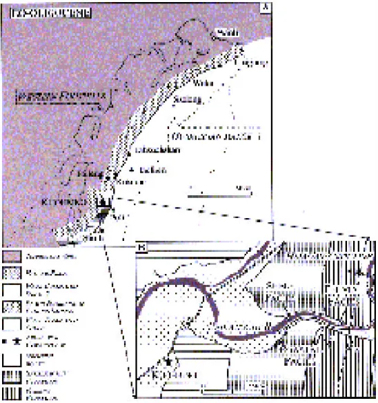
Figure 1. Schematic Eo-Oligocene paleoshoreline in Taiwan (A) (compiled from Tan and Youh, 1978; Sun, 1982; Wu, 1986; Huang and Huang, 1987; Chou, 1988; Teng et al., 1988; Teng et al., 1991; Liu, 1992 Ke, 1992 ; Tai et al., 19 94). Loac tion map of the me asured Eo-Oligocene strata i n Kuohsin g (B) (modified from Lo et al., 1992).
49
Yu et al.: Lower Oligocene Fluvio-Estuarine Facies
This compound interpretation, however, is challenged by increasingly detailed facies investigations in recent years, because the terrestrial deposits are rarely recognized and the
o c cu rre n c e s o f C. baronensis are found associated with the coastal deposits (e.g. Wu, 1986;
Huang and Huang, 1987; Teng et al., 1988; Teng et al., 1991; Huang and Lee, 1992; Liu, 1992; Ke, 1992; Tai et al., 1994). It is also confusing that the fluvial deposits, only identified in two localities, appear problematic owing to insufficient stratigraphic and facies constraints. For example, the sandy/coaly strata in Kuohsing, being exclusively attributed to fluvial deposition (Wu, 1986), require much refined facies delineations, because the brackish-water mollusks like
Ostrea sp. and Cerithidae sp. related to coastal deposition occur in the upper part (Tan, 1944,
1971; Kanno and Chung, 1975). The others in the Meichi Sandstone appear even more ambiguous in facies description and geological age controls (Huang and Lee, 1992).
Consequently, the strata in Kuohsing become the most crucial to examine the existence of late Oligocene fluvial deposition, and the fluvial-coastal facies variations in these comparable strata in Taiwan (Figure 1-B). To deal with these issues, this study first reinvestigates the outcrops along the Peikangchi River valley in Kuohsing to discriminate the facies characteristics of fluvial and coastal deposition. The overlying muddy/fossiliferous neritic strata are also documented to much completely display the vertical facies variations. The facies succession of the strata studied is further compared with the previous results of the other comparable strata to demonstrate the lateral facies variations. The preliminary outcomes show that the sandy/ coaly strata in Kuohsing are deposited in a fluvio-estuarine environment with the overlying neritic strata deposited in a shelf. This overall transgressive sequence separated by two marine-flooding surfaces reveals interesting findings regarding the rising sealevel. The comparison with the other successions provides new findings in the lateral facies changes and paleoshoreline configuration.
GEOLOGICAL BACKGROUNDS
The upper Paleogene strata expose in the axial area of a N-S anticline, i.e. the Hsiaoan Anticline, in the Peikangchi River valley near Kuohsing (Figure 1-B; Chiu, 1972, 1975; Lo et
al., 1999). The western flank with continuous outcrops is the main target of this study.
The rock strata are divided into the Paileng and Shuichangliu Formations in ascending order, dominated by the sandy/coaly strata and the muddy/fossiliferous strata, respectively (Figure 2; Hayasaka et al., 1939; Ho and Tan, 1960; Chiu, 1972; Lo et al., 1999). Lithological distinction is extremely obvious in the outcrops with sandstones and conglomerates concentrated in the Paileng, and mudstones and interbeds in the Shuichangliu. The succession measured in the western flank is composed of 300 meters of the Paileng Formation from the anticline axis, and 100 meters of the overlying Shuichangliu Formation. A deepening-upward trend in facies and a decreasing-upward trend in grain size and sand/mud ratio are significant in the succession (Fig. 2).
The Paileng Formation is generally low in fossil content, except some palm fragments and mollusks are recorded in the nearby areas, like fresh-/brackish-water Corbicula baronensis,
Taiwancorbicula chiuwongi, Ostrea sp. Cerithidae sp. and marine-water Troropicolpus sakitoensis (Figure 3-A; Hayasaka et al., 1939; Tan, 1944, 1971; Kanno and Chung, 1975).
The Shuichangliu Formation is rather abundant in marine fossils, including nannofossils, foraminifers, echinoderms and mollusks (Hayasaka et al., 1939; Tan, 1944, 1971; Chang, 1963; Kanno and Chung, 1973; Huang and Ting, 1979; Chi, 1979; Huang, 1986). The biostratigraphy based on micropalaeontology shows that the Shuichangliu Formation measured in the succession is early Oligocene in age with the delineation of P19-20 and NP23-24 biozones (Figure 2;
50
Huang and Ting, 1979; Chi, 1979; Huang, 1986). Therefore, the underlying Paileng Formation is most likely latest Eocene (?) to earliest Oligocene in age.
Figure 2. Stratigraphic and Facies columns of the measured lower Oligocene strata. Biostratigraphy of nannofossil and planktic foraminifer based on Huang and Ting (1979), Chi (1979) and Huang (1986). Bioturbation index after Dott and Bourgeois (1982). M: mud, SI: silt, SF: fine sand, SM: medium sand,
Yu et al.: Lower Oligocene Fluvio-Estuarine Facies
51
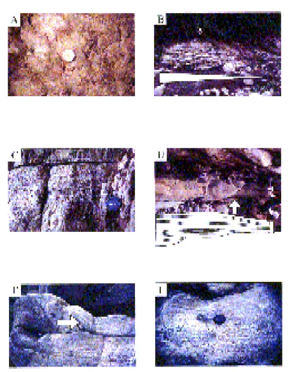
Figu re 3. (A) Gastropod s in th e sand stone l ayers of the Floodp lain a ssociat ion. (B) Erosion-ba sed, fining-upward sequence (horizontal triangle) of conglomerates, sandstones and interbeds from the Fluvial Channel to Natural Levee associations. (C) Grain-supported, gravelly c onglomerate with normal-grading planar stratifications in the Fluvial Channel association. (D) Mega-wave stratifications in the Fluvial Channel association. (E) Folded foreset of a trough cross bed in the Fluvial Channel association. (F) Normal-grading, planar stratifications in the Fluvial Channel gravelly sandstone.
FACIES ASSOCIATIONS
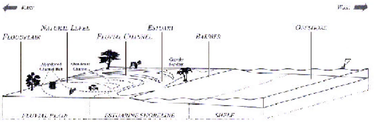
According to the facies characteristics observed in this investigation, the rock succession measured is evidently deposited in "Fluvial Plain, Estuarine Shoreline and Shelf" environments (Fig. 4). The lower 250m are composed of the fluvial plain strata with three facies associations including the fluvial channel, natural levee and floodplain (Figures 1-B, 2). The middle 70m are composed of the estuarine shoreline strata with 2 facies associations of the estuary and barrier. The upper 80m are composed of the shelf strata of the offshore facies association.
Figure 4. Schematic depositional model and facies associations of the lower Oligocene strata measured in Kuohsing.
Fluvial Channel
Description: The association is composed of sandstones and conglomerates in
erosion-based, fining-upward successions of 5~15 meters thick (Figures 3-B, 5). The sandstones are medium to coarse in grain size. The conglomerates are grain-supported, subangular to subrounded, and fine to medium in gravel size (Figure 3-C). Sedimentary structures include trough cross beds, planar stratifications, mega-wave stratifications and some planar cross beds (Figure 3-D). The cross beds, 20~40cm thick individually, usually form lateral-discontinuous, compound bed sets up to meters thick. The foresets are usually normal-graded, folded and climbing-stacked (Figures 3-E, F). Soft deformations are common, like load casts and slumping structures. The upper parts of the fining-upward successions are often associated with some rootlets, tiny tube-like traces and red beds (Figure 6-A).
Interpretation: The compound cross beds and fining-upward successions are indicative
of shifting traction flows (Massari, 1983). The mega-wave stratifications are formed almost instantly during deposition of strong eddy currents (Cotter and Graham, 1991). The folded foresets are originated from the semi-dewatered foresets dragged by succeeding flows (Hendry and Stauffer, 1977; Roe and Hermansen, 199 3). These sedimentary structures and soft deformations reflect abundant sediment supply in rapid deposition. The conglomerates are the winnowing-out deposits of sheet-like traction flows, which are usually aggregated in channel floor as gravel shoals or bars (Arche, 1983; Steel and Thompson, 1983). The rootlets and red beds are indicative of vegetation and weathering processes, which take place soon after the abandoned channels are filled.
53
Yu et al.: Lower Oligocene Fluvio-Estuarine Facies
Thus, the association represents the sediment fills of abandoned fluvial channels, which are deposited by powerful traction flows with abundant coarse-grained bed loads (Fig. 4). These channels are usually migrating laterally and floored by sandy/gravelly shoals due to rapid deposition.
Natural Levee
Description: The association is composed of sand/mud interbeds with thin conglomerates
of gravel or mud chip (Fig. 5). Fining-upward successions are common (Figure 6-B). Plant Figure 5. Ide alized facies a ssoc i at io n s o f th e Lo w e r Ol i g o c e n e st ra ta i n Ku oh si ng . Bi ot urba ti on i nd ex a ft e r D ro se r a n d Bo tt je r (1 98 8). Se e legend in Figure 2.
fragments, calcareous and ferruginous concretions are plentiful. Soft deformations and subaerial-exposed features are often encountered, like climbing laminations, slumping structures, ball and pillow, rootlets and paleosols (Fig. 6-C). Sedimentary structures include normal-graded planar stratifications, flaser laminations and some mega-wave stratifications.
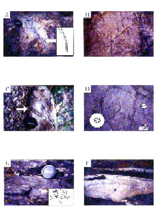
Figure 6. (A) Red bed (vertical arrow) and tiny traces (horizontal arrow) in the upper Fluvial Channel as sociation. (B) Fining-upward sequence (horizontal triangle) of stratified to laminated interbeds in the Natural Levee association. (C) Ball-and-pillow structure (arrow) in the stratified interbeds of the Natural Levee association. (D) Planar laminations in the Floodplain mudstone. (E) Bioturbated laminated interbeds rich in sulfurous
m aterials and trace fo ssils of Skolithos is p.; note the traces filled with coarse quartz sands (arrow). (F) A 1. 5-meter-thick coal bed overlain by a planar bedded quartz sands tone and a coaly mudstone with ferrous concretion (arrow).
Yu et al.: Lower Oligocene Fluvio-Estuarine Facies
55
Interpretation: The concretions, rootlets and paleosols reflect a depositional site with
insignificant perturbation, low water table and vegetation (Bown and Krause, 1987; Besly and Collinson, 1991; Krause and Aslan, 1993). The sandstone layers and sedimentary structures, however, indicate some instant deposition of intermittent flood currents.
Thus, the association represents the deposits in natural levees along fluvial channels (Fig. 4). In flood seasons, overbank currents frequently rip up previous alluvium and pave sheet-like sandy or gravelly deposits in the proximal riverbanks. As the currents drain, muddy deposits soon precipitate over the coarse-grained deposits. Out of flood seasons, vegetation grows on these deposits and causes pedogensis, as water table is lower.
Floodplain
Description: The association is composed of massive mudstones and some sand/mud
interbeds (Fig. 5). It is rich in plant fragments, calcareous and ferruginous concretions. Coal seams, horizontal tube-like traces and gastropods are occasionally encountered (Figure 3-A). Carbonaceous mudstone intervals are common. Sedimentary structures are rare and dominated by planar laminations (Figure 6-D). Soft deformations and subaerial-exposed features are recorded, like climbing laminations, ball and pillow, rootlets and paleosols.
Interpretation: The simple lithology, concretions, carbonaceous materials and coal seams
reflect a quiescence depositional site with low bioactivities, stagnant water circulation and frequent water-table fluctuations (Fielding, 1984; Haszeldine, 1984). The sedimentary structures and soft deformations are indicative of occasional abundant sediment supply and instant deposition of low-energy currents.
Thus, the association represents the distal riverbank deposits in a floodplain surrounding fluvial channels (Fig. 4). Thick muddy deposits cover most of this low-lying area with abundant carbonaceous materials in small lakes, ponds or marshes, where water table is usually high. In flood seasons, thin-layer coarse-grained deposits pave over the areas where overbank currents reach. The lakes, ponds and marshes near the fluvial channel are more easily drained or filled up by sediments, which makes the deposits much easily influenced by pedogensis. Those far from fluvial channels, receiving small amounts of silisiclastic deposits, tend to be enriched in carbonaceous materials and become mires for peat formation.
Estuary
Description: The association is composed of sand/mud interbeds and carbonaceous
mudstones with some coal seams (Fig. 5). Thin sandstones and mud-chip conglomerates are common. Ferruginous concretions, plant fragments and trace fossils filled with quartz grains are frequently encountered (Figures 6-E, F). The ichnofabrics include Ophiomorpha isp.,
Skolithos isp. and Planolites isp.. Sedimentary structures include planar stratifications, flaser
and wavy laminations with some planar cross beds and HCS. The sandstone beds are associated with climbing laminations, slumping and ball-and-pillow structures. The interbeds are characterized by sulfurous materials, ball & pillow, rootlets and paleosols (Figures 6-E, 7-A).
Interpretation: The interbeds, coal seams, concretions and carbonaceous materials reflect
a relatively quiescence depositional site with stagnant water circulation. Abundant sulfurous materials and trace fossils are indicative of marine water intrusion. The planar stratifications, wavy laminations and HCS suggest fair weather wave and storm wave activities. The flaser laminations with climbing features suggest rapid deposition of fluvial, tidal or wave-induced currents.
Figure 7. (A) A root structure penetrating a sandstone layer of the Estuary association. (B) Herringbone planar cross bed in the Barrier associa tion. (C) Trace fossil s of Scolicia isp. (arrow) of Cruziana ichnofacies on a sandstone tope of the Offshore association. (D) Trace fossils of Palaeodictyon isp. (in circ le) of Nerei tes ichno facies on a siltstone tope of th e Offshore associatio n. (E) Hori zontal traces filled with glauconitic pellets in the Offshore mudstone. (F) Sandstone layers with singular (upper thin layer) or amalgamated (lower thick layer) hummocky cross stratification of the Offshore association.
57
Yu et al.: Lower Oligocene Fluvio-Estuarine Facies
Thus, the association represents the deposits in an estuary under combined influences of fluvial and marine processes (Fig. 4). The lagoon-like area receives plentiful mud-dominated sediments from fluvial channels and inlets of storm washover or tidal currents, which in turn create excellent water circulation beneficial for the intense bioactivities. As sediment fills gradually shrink the estuary, vegetation grows over the exposed areas and causes pedogensis.
Barrier
Description: The association is composed of gravelly sandstones in fining-upward intervals
with basal erosion surfaces and load casts (Fig. 5). Although the sandstones are in various grain sizes, most of them are quartzites showing fairly mature lithology. Trace fossils are rare and dominated by Ophiomorpha isp.. Sedimentary structures well-developed, including planar stratifications, cross beds and herringbone cross beds (Figure 7-B).
Interpretation: The well-developed structures and mature lithology reflect a depositional
site with intense wave activities (Clifton et al., 1971; Greenwood and Mittler, 1985). The herringbone cross beds are indicative of multi-directional currents in time-velocity asymmetry (Visser, 1980; de Mowbray and Visser, 1984). The domination of Ophiomorpha isp. is indicative of a high-energy depositional sits with excellent water circulation. The fining-upward successions with basal conglomerates and erosion surfaces are attributed to the sediment fills of tidal inlets. Thus, the association represents the deposits in a barrier island (Fig. 4). These sandy deposits form a series of beach-shoreface shoals and bars fringing the seaward parts of the estuaries. They are dominated by fair-weather-wave activities and divided by tidal inlets, through which tidal currents flood into and ebb out of the estuaries.
Offshore
Description: The association is composed of mudstones, massive sandstones and stratified
interbeds (Fig. 5). Intervals rich in glauconitic pellets and shell fragments are common. Bioturbation is usually intense with ichnofabrics like Zoophycus isp., Chondrites isp., Scolicia isp. Palaeodictyon isp., Planolites isp., Skolithos isp., Teichichnus isp., Thalassinoides isp. and Ophiomorpha isp. (Figures 7-C, D). Some traces are filled with glauconitic pellets (Figure 7-E). Sedimentary structures include HCS, planar stratifications and wavy laminations (Figure 7-F).
Interpretation: The sedimentary structures are evidently related to storm wave activities.
The intense bioturbation suggests that wave activities are superseded by vigorous bioactivities between storms. The glauconitic intervals and in-situ glauconitic pellets are indicative of slow and quiescence deposition. Some traces are indicative of outer shelf to subabyssal environments, like Zoophycus isp., Chondrites isp., Scolicia isp. and Palaeodictyon isp..
Thus, the association represents the deposits in an offshore with occasional storm-wave influences and slow sediment supply (Fig. 4).
LOWER OLIGOCENE FLUVIAL SYSTEM
The fluvial succession in the section is composed of three coarsening-upward, 60~100m thick sequences, each of which displays an upward facies change from the floodplain, natural levee to fluvial Channel (Figures 2, 5). These sequences demonstrate a gradual progradation of the fluvial channel toward the natural levee and floodplain, which might be related to lateral migrations of channel belts, or baselevel falls (Fig. 4).
In these sequences, it is obvious that the floodplain in the fluvial plain mainly receives muddy deposits (Figure 5; Appendix). Only little proportion of coarse-grained deposits is accumulated in this low-lying area around the natural levee, whereas the majority is concentrated in the fluvial channel. Meanwhile, the conglomerates and gravelly sandstones form point bar sequences with well-developed sedimentary structures of traction flows. Therefore, it appears that the fluvial plain is dominated by the middle-lower reaches of a river system with sinuous channel belts (Figure 4; Collinson, 1996).
Yu et al.: Lower Oligocene Fluvio-Estuarine Facies
59
It is also significant in these sequences that most of the fluvial channel and natural levee associations are amalgamated to form channel-levee complexes (Figure 2; Appendix). The feature suggests that the main belts of these fluvial channels are potentially broad enough to accommodate all these gravelly/sandy bed loads (Fig. 4). Within these particular channel belts, the individual channel in the belts is ever changing in direction and usually floored by migrating gravelly shoals or bars, because the abandoned point-bar channel fills are stacked upward with compound cross beds and gravel beds (Fig. 5). These channel fills are characterized by well-developed features of rapid deposition, which in turn indicates that the traction-flow capabilities reduce considerably between floods without significant redistribution of the settled sediments. Consequently by integrating these features, the fluvial system can be specified as "middle/ lower reaches of a sandy bedload, low-sinuosity river system" associated with fluctuating water levels and tables (Fig. 4). Modern analogues are referred to the Platte River and the Calamus River, Nebraska, U.S. (Smith, 1970, 1971; Blodgett and Stanley, 1980; Bridge et al., 1986), the South Saskatchewan River, Canada (Cant and Walker, 1978), and the Squamish River, British Columbia (Brierley, 1989, 1991).
LOWER OLIGOCENE ESTUARINE SHORELINE SYSTEM
The total thickness of the estuarine strata in the section studied is about 70~90m, because the lower 20 meters from 230 to 250m is covered by dense vegetation without distinguishable outcrops (Appendix). These covered strata are fine-grained most likely, and tentatively interpreted as the estuary facies (Fig. 2).
Nevertheless, these coastal strata are indicators of a deepening and westward environment shift from the fluvial plain to estuarine shoreline (Figures 2, 4). Under the circumstances, deposition is likely to retrograde and lead to a much gentle and graded stream profile in the area to compensate the rising baselevel. Fluvial processes decrease as marine processes begin to influence this low-lying fluvio-estuarine plain. A typical quiescent estuary is resulted and starts accumulating thick piles of muddy deposits (Figures 4, 5; Dalrymple et al., 1992). River floods, storm washover currents and spring tides make thin laminated or sheet-like layers of sandy deposits available.
Further deepening and westward shift to the seaward part of the coastal environment takes place as sealevel keeps rising (Figures 2, 4). It results in the fluvial processes totally superseded by marine processes, which is dominated by fair weather waves with some tidal currents. Mostly deposited are coarse-grained deposits along the shoreline due to the intense wave influences, which is evidenced by the mature lithology and well-developed sedimentary structures in the barrier facies association (Fig. 5). Hence, a typical barrier environment is formed in the shoreface areas and starts accumulating thick piles of sandy/gravelly deposits (Reinson, 1992; Reading and Collinson, 1996).
In terms of the coastal facies succession, the estuarine system can be specified as a "wave-influenced barrier-estuary" shoreline (Fig. 4). Although these sedimentary environments are rather distinguishable in geomorphology, nevertheless the formation and preservation of the barrier facies is affected by several important factors. It heavily depends on the depositional and erosional processes of fair weather waves, and indirectly on the critical balance between
sediment supply and rate of sealevel rise (Belknap and Kraft, 1981; Swift and Moslow, 1982; Galloway, 1986). Since the barrier facies association is well recognized in the section studied (Fig. 2), it in turn indicates that the sediment supply in this shoreline is sufficient to balance the rate of sealevel rise (Fig. 4).
FLUVIAL-ESTUARINE-SHELF SEQUENCE
In terms of the facies associations, the succession changes from the fluvial, estuarine to shelf deposits, which displays a transgressive sequence and verifies the similar variations reported in mollusk faunas (Kanno and Chung, 1975). Furthermore, two marine-flooding surfaces are recognized by the deepening-upward facies, and reveal the variations of sealevel rise in the whole sequence.
The lower surface, located at 230m in the succession, is characterized by the change from the fluvial to estuarine deposits (Fig. 2). The overlying estuarine succession up to 70~90m thick clearly suggests that this particular barrier/estuary system must have sustained for a period of time under the balance between the sealevel rise and sediment supply (Belknap and Kraft, 1981; Swift and Moslow, 1982; Galloway, 1986). During this duration, some sealevel fluctuations or lateral environment shifts still take place, which is indicated by the stacked barrier and estuary deposits. Since individual barrier or estuary association is distinguishable, the preservation of th ese coastal deposits appears rather complete during these sealevel fluctuatio ns or environment shifts. It, in turn, suggests that these fluctuations or shifts are relatively minor and only associated with insignificant transgressive erosion, since the erosion is often able to cause total destruction of the coastal deposits (Swift, 1968; Reinson, 1992; Dalrymple et al., 1992).
The upper surface, located at 325m, is characterized by the change from the estuarine to shelf deposits (Fig. 2). The offshore facies directly overlies the estuary facies with an intensely bioturbated coarse sandstones of 1m thick. The sandstone is characterized by relict HCS and low-angle planar stratifications, which are indicative of storm wave deposition in the offshore environment. On the other hand, its coarse-grained lithology reflects storm washover deposition in the estuary environment. The lack of intervening barrier facies might be due to none deposition during the sealevel rise, or none preservation after the sealevel rise. Regardless in either cases, this particular sealevel rise is likely rapid enough to overwhelm sediment supply and result in none deposition, or to cause intense transgressive erosion and result in none preservation (Belknap and Kraft, 1981; Swift and Moslow, 1982; Galloway, 1986).
Thus, it appears that the initial sealevel rise, at the first marine-flooding surface, not only results in the fluvio-estuarine succession, but also is superimposed by minor sealevel fluctuations or lateral environment shifts. The following sealevel rise, at the second marine-flooding surface, causes the coastal area inundated as an open shelf, but also ceases the eastbound fluvial progradation to the west of Kuohsing during Oligocene and the rest of Cenozoic.
The later drastic and rapid transgression is also recorded by early Oligocene environment deepening in many other areas in northern Taiwan, such as Wulai, Paleng, Pinglin and North Coast (Teng et al., 1991). In Wulai, similar coastal inundation is displayed by the abrupt facies deepening from the barrier-lagoon to the offshore transition in the upper Szeleng Sandstone (Teng et al., 1988). In North Coast, environment deepening is displayed by the abrupt facies
Yu et al.: Lower Oligocene Fluvio-Estuarine Facies
61
deepening from the shoreface to the offshore, at the boundary between the Szeleng Sandstone and Kankou Formation in Lungtung, and in the lower Wuchihshan Formation in Wanli (Tai et
al., 1994). These concomitant transgressive events are comparable to the Kuohsing event with
a similar age range in lower NP23 o r lower N19~20 biozones.Thus, it appears that the transgression is tectonically controlled and related to the late Paleogene rifting activities in the SE China continental margin (Tang et al., 1991).
PALEOSHORELINE IMPLICATIONS
The sandy/coaly strata studied are the only recognized with fluvial deposits among the upper Paleogene strata, although comprising considerably minor proportion of the whole formation, over 4,000 meters thick (Ichimura, 1938; Chen, 1977; Chou, 1988). Thus, the comparison between these sandy/coaly strata is able to provide insights into the lateral facies changes as well as the paleoshorelines.
The most significant consistency in the facies comparison is the estuarine strata studied and the other coastal strata, because they are all indicative of deposition in shorelines under distinguishable wave influences (e.g. Huang and Huang, 1987; Teng et al., 1988; Teng et al., 1991; Huang and Lee, 1992; Liu, 1992; Ke, 1992; Tai et al., 1994). Yet discrepancies emerge due to the existence of the fluvial strata studied in Kuohsing, which results in the remarkable differences from the fine-grained coastal deposits, especially. For example, the barrier strata are usually associated with the lagoon deposits without fluvial influences in many other areas, including the Paileng Formation in Paileng (Liu, 1992), the Szeleng Formation in Wulai, Szeleng and Paileng (Teng et al., 1988; Teng et al., 1991; Ke, 1992). Furthermore, the lack of fluvial influences is also observed in other similar barrier-lagoon Neogene strata in the Western Foothills and bear corresponding discrepancies, like the lower Miocene Mushan Formation and upper Miocene Sanfuchi Sandstone (Yu and Teng, 1995; Yue and Teng, 2000).
Concerning the fluvial strata studied, the facies changes become even drastic and appear deepening toward the north, south and east (Figure 1-A). To the north, the sandy/coaly strata of the Paileng Formation in Paileng are deepening in facies, like the barrier, lagoon, foreshore and shoreface deposits (Figure 1-A; Liu, 1992). Further down to the NNE in Szeleng and Wulai, they are also deepening in facies and intercalated by the muddy/fossiliferous offshore strata (Teng et al., 1988; Ke, 1992). To the south and east, they are both composed of the wave-influenced paralic deposits and intercalated by muddy/fossiliferous neritic deposits in the Tachian Sandstone in Shuili and the Paileng Formation near Puli, (Huang and Huang, 1987; Tan and Youh, 1978). The Shuili Tachian Sandstone and the Puli Paileng Formation have been suspected attributed to deltaic progradation, albeit detailed facies characteristics remain to be investigated to verify the fluvial influences and corresponding river systems. In such case, it seems that the eastbound fluvial system in Kuohsing is likely related to the corresponding river system of the deltaic deposition.
By integrating these facies changes, the paleoshorelines, based on previous studies (Tan and Youh, 1978; Chou, 1988), is preliminarily redrawn in Figure 1-A with improvements on sedimentary processes and environments. It is obvious that the paleoshorelines, smoothly extending from northeastern to southwestern Taiwan, are composed of a series of
wave-62
influenced environments. However, the smoothness is interrupted with protrusion to the east of Kuohsing due to the fluvial and related deltaic deposition. This feature is very unique in the Tertiary sedimentation in Taiwan, and worthy of further investigations.
CONCLUSION
The sedimentary nature of the lower Oligocene sandy/coaly strata in Kuohsing is clarified by the facies reinvestigation of this study. The strata are deposited in a fluvio-estuarine environment, and overlain by the shelf muddy/fossiliferous strata. The fluvial deposits are accumulated in the middle-lower reaches of a low-sinuosity, sandy bedload river system, with three depositional sites of the fluvial channel, natural levee and floodplain. The overlying estuarine deposits are accumulated in the wave-influenced, estuarine shoreline with two depositional sites of barrier and estuary. The shelf deposits are accumulated in the wave-influenced offshore. The fluvial-estuarine-shelf succession, displaying a transgressive sequence, is characterized by two marine-flooding surfaces, which represent the onsets of two stages of sealevel rise. The lower surface between the fluvial and estuarine strata is indicative of a slow-rising sealevel, which seems to be in balance with the sediment influx and leads to limited marine intrusion into the previous fluvial plain. The upper surface between the estuarine and shelf strata is indicative of a major and rapid sealevel rise which overwhelms the sediment influx, and is likely related to the tectonic rifting in the SE China continental margin.
The paleoshorelines are mostly composed of a series of wave-influenced environments, based on the comparison between the fluvio-estuarine strata studied and the other upper Paleogene strata. It is also significant that the eastbound fluvial deposits seem related to an eastward protrusion in the wave-influenced NE-SW paleoshoreline, and responsible for the deltaic deposition in the south and southwest.
ACKNOWLEDGMENTS
The writers would like to thank Mr. L.F. Yue, C.B. Hsu, W.Y. Yu and N.W. Huang for their helps in the fieldwork. Special thanks are due to Prof. W.S. Chen for valuable discussion and advise. Miss W. Chen is appreciated for revising the text and figures. This paper was financially supported by the projects of NSC 88-2116-M-002-013 and NSC 89-2116-M-002-042.
REFERENCES
Arche, A. (1983) Coarse grained meander lobe deposits in the Jarama River, Madrid, Spain. in Collinson, J.D. and Lewin, J. ed., Modern and Ancient Fluvial Systems: Spec. Pub. Int. Ass. Sed., 6, 313-332. Belknap, D.F. and Kraft, J.C. (1981) Preservation potential of transgressive coastal lithosomes on the U.
Yu et al.: Lower Oligocene Fluvio-Estuarine Facies
63
Besly, B.M. and Col linson, J.D. (199 1) Volca nic and tect onic cont rols of lacu stri ne a nd a lluv ial sed iment ation in th e Ste phani an coa l-bea ring seque nce o f the Malpa s-Sort Basin, Ca talon ian Pyrenees: Sedimentology, 38, 3-26.
Blodgett, R.H. and Stanley, K.O. (1980) Stratificati on, bedforms, and discharge relations of the Platte braided river system, Nebraska: J. of Sed. Petrol., 50, 139-148.
Bown , T.M. and Krau s, M.J. (1987) Integra tion of channe l and fl oodplai n suite s, I. De velopme ntal sequences and lateral relations of alluvial paleosols: J. Sed. Petrol., 57, 587-601.
Brierley, G.J. (1989) River planform facies models; the sedimentology of braided, wandering nd meandering reaches of the Squamish River, British Columbia: Sedi. Geol., 61, 17-35.
Brierley, G.J. (1991) Bar sedimentology of the Squamish River, British Columbia; definition and application of morphostratigraphic units: J. of Sed. Petrol., 61, 211-225.
Chang, L.S. (1963) A biostratigraphic study of the so-called Hori Slate in central Taiwan based on small foraminifera: Proc. Geol. Soc. China, 6, 3-17.
Chen, C.H. (1977) Some stratigraphic problems of the Hsuehsha n Range of Taiwan: Proc. Ge ol. Soc.
China, 20, 61-70.
Chi, W.R. (1979) Calcareous nannoplankton biostratigraphy of the Nantou area, central Taiwan: Petro.
Geol. Taiwan, 16, 131-165.
Chiu, H.T. (1972) Miocene stratigraphy of the Nantou area, central Taiwan: Petro. Geol. Taiwan, 10, 159-177.
Chiu, H.T. (1975) Miocene stratigraphy and its relation to the Paleogene rocks in west-central Taiwan:
Petro. Geol. Taiwan, 12, 51-80.
Chou, J.T. (1988) Eocene formations in Taiwan: Petro. Geol. Taiwan, 24, 51-59.
Clifton, H.E., Hunter, R.E. and Phillips, R.L. (1971 ) Depositional structures and processes in the non-barred high-energy nearshore: J. Sed. Petrol., 41, 651-670.
Collinson, J.D. (1996) Alluvial sediments. in Reading, H.G. ed., Sedimentary Environment: Processes, Facies and Stratigraphy, 3rd ed: Blackwell, 37-82.
Cotter, E. and Graham, J.R. (1991) Coastal plain sedimentation in the late Devonian of southern Ireland; hummocky cross-stratification in the fluvial deposits?: Sed. Geol., 72, 201-224.
Dalrymple, R.W., Zaitlin , B.A. and Boy d, R. (1992) Estuari ne faci es mode ls: con ceptua l basis and stratigraphic implications: J. Sed. Petrol., 62, 1130-1146.
Dott, R.H.Jr., an d Bourgeois, J. (1982) Hummocky st ratification: significance of its variable bedding sequences: Geol. Soc. Am. Bull., 93, 663-680.
Fielding, C.R. (1984) Upper delta plain lacustrine and fluviolacustrine facies from the Westphalian of the Durham coalfield, NE England: Sedimentology, 31, 547-567.
Galloway, W.E. (1986) Reservoir facies architecture of microtidal barrier systems: AAPG Bull., 70, 787-808.
Greenwood, B. and Mittler, P.R. (1985) Vertical sequence and lateral transgression in the facies of a barred nearshore environment: J. Sed. Petrol., 55, 366-375.
Haszeldine, R.S. (1984) Muddy deltas in freshwate r lakes, and tectonism in the Up per Carboniferous Coalfield of NE England: Sedimentology, 31, 811-822.
64
Hayasaka, I. and other members of the Geological Institute, Taihoku Imperial University (1939) Report on the Geological Observations in the Area Disturbed by tge Earthquake of 1935, with Geological Map in the scale of 1:100,000 (in Japanese): Govern. Gen. of Taiwan, 1939, 79p.
Hendry, H.E. and Stauffer, M.R. (1977) Penecontemporaneous folds in cross-bedding: Inversion of facing criteria and mimicry of tectonic folds: Geol. Soc. Am. Bull., 88, 809-812.
Hisazumi, H. (1939) Report of survey of the Nanto petroleum reserve, Taich u Province (in Japanese):
Govern. Gen. of Taiwan, 1939, 64p.
Ho, C.S. and Tan, L.P. (1 960) Geology and coal deposit of the area betwee n Tungshih, Taichung and Kuohsing, Nantou, Taiwan: Bull. Geol. Surv. Taiwan, 12, 19-62.
Huang, C.S. and Lee, C.F. (1992) Sedimentary environments of the Meichi Sandstone and its contact relationship with the Szeleng Sandst one, Hsuehshan Range (in Chinese): Cent. Geol. Surv. Spec.
Pub., 6, 143-152.
Huang, C.S. and Huang, C.C. (1987) Delta facies o f Paleogene rocks a long the Sunhai log ging road, central Taiwan: Proc. Geol. Soc. China, 30, 94-101.
Huang, C.Y. (198 6) Oligocene and Miocene strati graphy of the Kuohsing area, c entral Taiwan: Ac ta
Geol. Taiwanica, 24, 281-318.
Huang, T.C. and Ting, J.S. (1979) Calcareous nannofossil succession from the Oligo-Miocene Paikangchi section and revised stratigraphic correlation between northern and central Taiwan: Proc. Geol. Soc.
Taiwan, 22, 105-120.
Ichimura, T. (1938) sandstones from the Siryo and Hakurei Formations (in Japanese): Taiwan Tigaku
Kizi, IX (3), 48-66.
Kanno, S. and Chung, C.T. (1973) Molluscan fauna from the so-called Paleogene formations in northern Taiwan: Geol. Palaeontol. SE Asia, 13, 91-127.
Kanno, S. and Chung, C.T. (1975) Tertiary formations and their molluscan faunas from the Central Range and Foothills areas of northern Taiwan: Geol. Palaeontol. SE Asia, 15, 363-391.
Ke, A.X.W. (1992) Paleoenvironment analysis of the Szeleng Sandstone in northern Taiwan (in Chinese):
MS thesis, Inst. Geol., Nat'l Taiwan Univ., 89p.
Krause, M.J. and Aslan, A. (1993) Eocene hydromorphic paleosols: significance for interpreting ancient floodplain processes: J. Sed. Petrol., 63, 453-463.
Liu, H.C. (1992) Paleoenvironmental study of the Paileng Formation on the Hongliuchi and Tungmaochi section, the Tachiachi area, middle Taiwan (in Chinese): Ti-Chi, 12, 199-212.
Lo, W., Wu, L.C. and Chen, H.W. (1999) Summary, in Explanatory text of the geological map of Taiwan, Sheet 25, Kuohsing: Cent. Geol. Surv., MOEA, R.O.C., 71p.
Massari, F. (1983) Tabular cross-bedding in Messinian fluvial channel conglomerates, Southern Alps, Italy. in Collinson, J.D. and Lewin, J. ed., Modern and Ancient Fluvial Systems: Spec. Pub. Int. Ass.
Sed., 6, 287-300.
McCubbin, D.G. (1982) St orm- and tide- dominated shorelines in Cretace ous Moosebar-Lower Gates Interval-outcrop equivalents of deep basin gas trap in western Canada: AAPG Bull., 66, 138-157. de Mowbray, T. and Visser, M.J. (1984) Reactivation surfaces in subtidal channel deposits, Oosterschelde,
Yu et al.: Lower Oligocene Fluvio-Estuarine Facies
65
Reading, H.G. and Collinson, J.D. (1996) Clastic coasts. in Reading, H.G. ed., Sedimentary Environment: Processes, Facies and Stratigraphy, 3rd ed., Blackwell, 154-231.
Reinson, G.E. (1992) Transgressive barrier island and estuarine systems. in Walker, R.G. and James, N.P. ed., Facies Models Response to Sea Level Changes: Geol. Ass. Can., 157-179.
Roe, S.L. and Hermansen, M. (1993) Processes and products of large, Late Precambrian sandy rivers in northern Norway. in Marzo, M. and Puigdefabregas, C. ed., Alluvial Sedimentation: Spec. Pub. Int.
Ass. Sed., 17, 151-166.
Smith, N.D. (1970) The braided stream depositional environment; comparison of the Platte river with some Silurian clastic rocks, north-central Appalachians: Geol. Soc.Am.Bull., 81, 2993-3013. Smith, N.D. (1971) Transverse bars and braiding in the lower Platte River, Nebraska: Geol. Soc.Am.Bull.,
82, 3407-3420.
Steel, R.J. and Thompson, D.B. (1983) Structures and textures in Triassic braided stream conglomerates ('Bu nt er' Pe bb le B ed s) i n th e Sh erwo od San dsto ne Gro up , No rt h St affo rd sh ire, Eng la nd :
Sedimentology, 30, 341-367.
Sun, S.C. (1982) The Tertiary basins of offshore Taiwan: Proc. 2nd. ASCOPE Con and Exhib., 1981, 126-135.
Swift, D.J.P. (1968) Coastal erosion and transgressive stratigraphy: J. Geol., 76, 444-456.
Swift, D.J.P. and Moslow, T.F. (1982) Holocene transgression in south-central Long Island, New York-discussion: J. Sed. Petrol., 52, 1014-1019.
Tai, P.C., Lin, W.L. and Teng, L.S. (1994) Depositional enviro nment of the Wuchihshan Formation, northern coastal Taiwan (in Chinese): Ti-Chi, 14, 129-156.
Tan, K. (1944) On the Urai series, especially on the same age of the Yonryo Sandstone Formation, Hakurei Formation, and Niitaka Formation: Trans. Nat. Soc. Taiwan, 34, 174-223
Tan. K. (1971) The Paleogene stratigraphy and paleontology of Taiwan: The Publishing Committee of
the Manuscript by the Late Professor Dr. K. Tan, 55p.
Tan, L.P. and Youh, C.C. (1978) Characteristics and paleogeographic environment of the metamorphosed high-purity sandstone deposits in Taiwan: Proc. Geol. Soc. China, 21, 92-100.
Teng, L.S., Huang, C.Y. and Lee, C.T. (1988) Sedimentary features and depositional environments of the Wulai Group in the Wulai-Pinglin area, northern Hsuehshan terrain, Taiwan: Proc. Geol. Soc. China,
31, 101-118.
Teng, L.S., Wang, Y., Tang, C.H., Huang, C.Y., Huang, T.C., Yu, M.S. and Ke, A. (1991) Tectonic aspects of the Paleogene depositional basin of northern Taiwan: Proc. Geol. Soc. China, 34, 313-336. Visser, M.J. (1980) Neap-spring cycles reflected in Holocene subtidal large-scale bedform deposits: a
preliminary note: Geology, 8, 543-546.
Wu, L.C. (1986) Palaeoenvironmental analysis of the Oligocene and Miocene series in the Kuohsing area, central Taiwan (in Chinese): MS thesis, Inst. Geol., Nat'l Taiwan Univ., 96p.
Yen, T.P. and Chiu, H.T. (1983) The Eocene formations and magmatism in the Ryukyu-Taiwan-Philippine region: Mem. Geol. Soc. China, 5, 211-226.
Yu, N.T. and Teng, S.L. (1995) The lithofacies and sedimentary environments of the Miocene outcrops of the Chuhuangkeng section, northwestern Taiwan (in Chinese): Ti-Chi, 15, 127-151.
Yue, L.F. and Teng, L.S. (2000) Sedimentary facies and depositional cycles of the Mushan Formation (in Chinese): Bull. Cent. Geol. Surv., 13, 157-194.