544-552 | West Palm Beach, Florida I Summer 2001
The Influence of River Discharge on Salinity Intrusion
in the Tanshui Estuary, Taiwan
Wen-Cheng Liu,t Ming-Hsi Hsu,$ Albert Y. Kuo,¶ and Jan-Tai Kuo*
tHydrotech ResearchInstitute
National Taiwan University Taipei 10617, Taiwan
tDepartment of Agricultural
Engineering and Hydrotech Research Institute National Taiwan University Taipei 10617, Taiwan
¶School of Marine Science
Virginia Institute of Marine
Science
The College of William and
Mary
Gloucester Point, VA 23062, U.S.A.
*Department of Civil Engineering and Hydrotech Research Institute National Taiwan University Taipei 10617, Taiwan
ABSTRACT
LIU, W-C.; HSU, M-H.; KUO, A.Y., and KUO, J-T., 2001. The influence of river discharge on salinity intrusion in the Tanshui Estuary, Taiwan. Journal of Coastal Research, 17(3), 544-552. West Palm Beach (Florida), ISSN 0749-0208. The Tanshui River system is the largest estuarine system in Taiwan, with drainage basin including the capital city of Taipei. It consists of three major tributaries: the Tahan Stream, Hsintien Stream and Keelung River. A vertical two-dimensional numerical model is refined and expanded to handle tributaries as well as the main stem of an estuarine system, and applied to the Tanshui River estuarine system.
Observed time series of salinity data and tidal-averaged salinity distributions have been compared with model results to calibrate the turbulent diffusion coefficients. The overall model verification is suggested to be achieved with comparisons of residual currents and salinity distribution. The agreement between observed data and computed re-sults put the stamp of approval on the model. The model is shown capable of reproducing the prototype water surface elevation, currents and salinity distributions. This paper emphasizes model applications. As an example of model utilities, the calibrated and verified model is used to calculate the salinity distributions under various conditions. The salinity distributions are simulated and compared under several scenarios of wastewater diversion and under various hydrological conditions to examine their response to the amount of freshwater inflows in the Tanshui River system. We find that the Tanshui River system is a partially mixed estuary in most instances and its salinity is very sensitive to river discharge. The model is also used to investigate the salinity response to the pulse of high freshwater discharge. The salinity has a very quick response and recovers to its original condition in about 7 days. The calculated estuary flushing time was strongly dependent on river flow and varied between hours to a month.
ADDITIONAL INDEX WORDS: Estuary, salinity intrusion, numerical model, freshwater discharge, model application,
Tanshui estuary, Taiwan.
INTRODUCTION
To predict hydraulic transport of materials in streams to an estuary and then into the ocean one requires understand-ing of river discharge rates and water movement in estuary. The hydrodynamic characteristics of tidal rivers have prop-erties of fluvial (unidirectional) flow and marine nearshore (bi-directional) flow. The former includes seasonal and tran-sient variations of freshwater discharge while the latter is dominated by tide, and complicated by salt-freshwater inter-action as well as meteorological events.
Numerical models designed to simulate transport process in estuaries should provide a detailed account of both advec-tive and turbulent diffusive transport of materials. Many ver-tical-longitudinal hydrodynamic models (x - z models) have been developed and used in estuarine studies (JOIINSON, 1981). The type of model may be either purely vertical-lon-gitudinal (assumes rectangular cross section), or just later-ally averaged. HAMILTON (1975) developed a vertical two-di-mensional numerical model of rectangular geometry to study circulation in the Rotterdam Waterway, i.e., nonlinear
gov-00012 received 5 February 2000; accepted in revision 17 July 2000.
erning equations were derived in Cartesian coordinates and simplified by assumriing that all channel cross sections were rectangular. BLUMBERG (1975; 1977; 1978), ELLIOTT (1976)
and RAo (1995) included nonuniform geometry in their two-dimensional models of the Chesapeake Bay, Potomac River, and Godavari estuary. BOERICKE and HOGAN (1977) devel-oped a laterally averaged model to study the effects of ther-mal discharge on the dynamics of the lower Hudson River.
WANG and KRAVITZ (1980) developed a semi-implicit, two-dimensional model for circulation of a partially mixed estu-ary. Application of their model to the Potomac River indicated large longitudinal and vertical changes in tidal, density-driv-en and wind-drivdensity-driv-en circulation, which suggested that two-dimensional (in a vertical plane) modeling is essential in the transport and mixing study. Their results, together with ob-servations indicated that the advection and mixing processes in a narrow, partially mixed estuary can be properly modeled
by including the vertical dimension. EDINGER and BucHAK
(1981) modified a computer application originally developed to study laterally averaged reservoir circulation and applied it to the Potomac River estuary. The nonlinear equations in conservative form were solved in Cartesian coordinates by
-F 17 1 3. I
i Journal of Coastal Research
IdIffiftel.,
0*00*-0
m
gw-River Influence on Salinity Intrusion5
12! E
Taiwan Strait
Wu-Tu
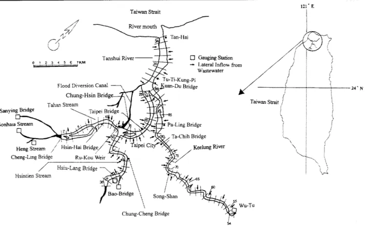
Figure 1. Map of the Tanshui River System and the model segments.
finite difference methods. PERRELS and KARELSE (1981) de-veloped a laterally averaged model with branching network capabilities to study circulation in the Rotterdam Waterway. Objectives of the present study are to gain additional in-sight into the vertical variations of hydrodynamic properties in the Tanshui estuary and to determine how these
proper-ties are affected by Ruvial freshwater discharge variations and by oceanic tides. Since vertical variations are present mainly in the deep channels of the estuary, a suitable later-ally averaged model may reproduce primary estuarine pro-cesses occurring in the deep channels.
Numerical models can quantify such processes over a wider range of river flow conditions than might be possible with a field program. In addition, a properly calibrated model pro-vides information on salinity distribution throughout the full length of the estuary, rather than at necessarily limited and selective sampling locations. In this study, a laterally inte-grated, two-dimensional, real-time model of hydrodynamics and salinity is developed and expanded to handle tributaries as well as the main stem of an estuarine system, and applied to the Tanshui River estuary.
STUDY ARF4
The Tanshui River is formed by the confluence of Tahan Stream, Hsintein Stream and Keelung River (Figure li. Downstream portions of all three tributaries are influenced
by tide,. and subjected to sea water intrusion. Together, they
form the largest estuarine system. in Taiwan. The major
por-tion of the estuarine system, upstream of Kuan-Du (Figure
1), lies within the Taipei basin, while the stretch downstream
is confined by high mountains on both sides. In addition, the
river is narrow that there is no significant wind-induced
cur-rent in the river. The major forcing mechanisms of the flows
are astronomical tide at river mouth and river discharges at
upriver ends. Semi-diurnal tides are the principal tidal
con-stituents, with a mean tidal range of 2.22 m and a spring
tidal range of 3.1 m. The average river discharges at the
up-stream limits of tide are 62.1 m3ls, 72.7 m.3/s, 26.1 m3/s,
re-spectively, in the Tahan Stream, Hsintien Stream and
Kee-lung River. The river system has a total drainage area of
2726 km
2, and a total channel length of 327.6 km. The
av-erage slope of the study reach is about 0.022 on 100. In
ad-dition to the barotropic flows forced by river discharges and
tides, the baroclinic flow caused by density difference is
an-other important transport mechanism in the Tanshui River
estuary system.
Six rnillion people, over a quarter of Taiwan entire
popu-lation, reside in the catchment area of the Tanshui River
svs-tem. The river system receives untreated domestic discharge
and both treated and untreated industrial effluents, thus, it
is heavily polluted. The upper estuary is normally suboxic
and gradually becomes oxic in the lower estuary with
increas-ing dilution by sea water
(CHEN
and HUNG, 1988).
Journal of Coastal Research, Vol. 17, No 3, 2001
N
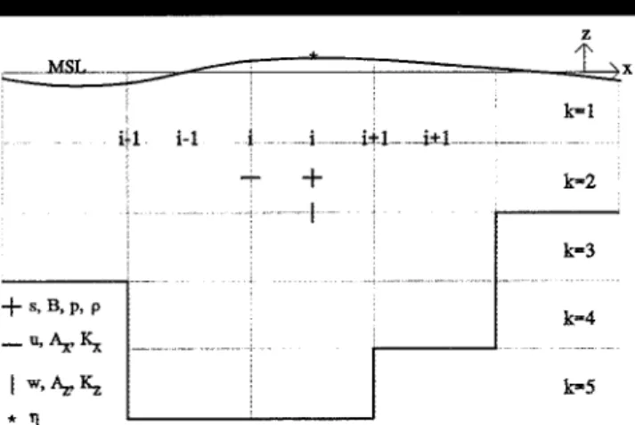
Liu et al. z MAL ____________________iN k=I k-2 ' + ' I ... .I k-3 k-4 k-5
z- directions, respectively, B = river width, q, = lateral in-flow per unit bank area, and
a
a
u
d
-(B,,q) +4 - I(uB) dz = q
at,
ax fI
(2where t = time, q = position of the free surface above mean sea level, B, = river width at the free surface including side storage area, H = total depth below mean sea level, q = lateral inflow per unit river length. Equations (1) and (2) are the laterally and sectionally, respectively, integrated conti-nuity equations for incompressible flow. The momentum bal-ance equation is
a(uB) auBu) a(uBw)
at
ax
az
Figure 2. C-rid pattern, location and indexing of variables.
(3)
ax
axI
ax,
a I
azu
= _B dp
+d
(A~B -1ud (A B_
p ax
Wx " ax
az (I
az!
The dynamic processes involving the interaction between river discharge and tidal currents are complex and lead to a series of distinctive types of estuarine circulation in the Tan-shui estuary. A numerical model was used to simulate the complex circulation patterns. Observed time series salinity and tidally-averaged salinity distributions are compared with model results to validate the turbulent diffusive coefficients. The model was shown capable of reproducing the observed circulation and salinity conditions (Hsu et al., 1999). A brief description of model calibration and verification procedures are presented in the next section. This paper emphasizes model applications. The salinity distributions are simulated and compared under several scenarios of wastewat;er diver-sion and various hydrological conditions. The model is also used to investigate the salinity response to the pulse of high freshwater discharge. The flushing time of the estuary is also calculated.
DESCRIPTION AND CALIBRATION
OF THE MODEL
The laterally integrated two-dimensional hydrodynamic model developed by Kuo et al. (1978) was modified for appli-cation to the Tanshui River system. The original version is applicable only to a single stem estuary. The model is ex-panded to include the simulation of tributaries which is nec-essary because of the three major tributaries in the tidal por-tion of the system. Assumppor-tions for the validity of the gov-erning equations are: (1) variations of dependent variables in the transverse direction are small and negligible and (2) the lateral average of the transverse velocity component is zero. The hydrostatic approximation and the Boussinesq approxi-mation are also assumed to be valid (BLUMBERG, 1977). With a right-handed Cartesian coordinate system with the x-axis directed seaward and the z-axis directed upward (Figure 2), the governing equations may be written as followings. The continuity equations are
a(uB)
a(wB)
ax
az
where p and p = pressure and density, respectively, A, and Ax = turbulent viscosities in the x- and z- directions, respec-tively. This is the laterally integrated equation of motion for incompressible, but non-homogeneous flow and represents the momentum balance along the longitudinal axis of an es-tuary. The hydrostatic equation is
ap
_z = -pg
dz
(4)where g = gravitational acceleration. When the hydrostatic approximation (i.e., gravity is the dominant force in the ver-tical direction) is applied to the equation of motion in the z-direction, the result is the hydrostatic solution given by equa-tion (4). The laterally integrated mass balance equaequa-tion for dissolved salt is
a(sB)
a(sBu)
_a(sBw)
aas
a
B-_
at
ax
az
dx
B +z ZBdza
S--
(5)where s = laterally averaged salinity, K, and K, = turbulent diffusivities in the x- and z- directions, respectively, SO = source and sink of salt water. The equation of state is
p = p1( + ks) (6)
where p. = density of fresh water and a constant k = 7.5 X 10⁻⁴ ppt-'. The density is related to the salinity by the sim-plified equation of state (equation (6)), which is usually re-garded as a satisfactory approximation because of the large spatial gradients of salinity in estuaries (HAMILTON 1977). The turbulent closure model uses the Munk-Anderson type formulations:
/ 2auH2/2.rr
A, = Z2(I-I
(1
+
P3Ri)-
1 2-i _ Texp(- ZK~
= otz2( _ Z) | ( +PRi
)--3/2 + Ct, _2exp _ iZh'/ az'T
L
I n h ,az
(7) (8)(1)
where u and w = laterally averaged velocities in the x- and
where Z and h = distance from the surface and total depth (h = qn + H), R, = local Richard number, H,, T and L =
Journal of Coastal Research, Vol. 17. No. 3, 2001
+ s, B, p, p
- u, A. K; I w, Az, 546
River Influence on Salinity Intrusion
height. period and length, respectively. of wind-induced waves, a,, 3 and a>, = constants.
The system of equations is solved using finite difference method with uniform grid of spatially staggered variables. Equations (1' to i.3, are solved to obtain the time-varying so-lution of the free surface tTP and laterally averaged velocity fields (u and w). The pressure term (p) is evaluated using equation X 4 w with the water density (pi from equation (6), and salinity s) using equation (.5). The detailed description of the method of solution including boundary conditions, turbulence closure model, treatment of the interaction of tributaries and main stem, and stability criteria can be found in Hsu et at.
(1996; 1997).
The layout of the grid system used in the model and loca-tions of variables within the grid are shown in Figure 2. The grid system has a defined at the middle of each segment, while s, B, p and p at the center of the grid cell. The variables, w. A, and K.. are defined at the bottom face of the grid cell, while the grid containing u, A, and K, is staggered by half the segment length as these are defined at the grid cell walls. The staggered grid structure, also used by many other inves-tigators, permits easy application of the boundarv conditions and evaluation of the dominant pressure gradient force with-out interpolation or averaging ,BLUTMBERG, 1977).
In the application to the Tanshui estuarine system, the model treats the Tanshui River and Tahan Stream as the main stem and Hsintien Stream and Keelung River as trib-utaries. They are divided into 33, 14, and 37 segments, re-spectively, with a uniform segment length of 1.0 km. The ver-tical grid spacing is I m for all layers, except the surface layer which is variable, with 2 m at mean sea level. Details of mod-el calibration and verification have been presented in Hsu et at. (1996: 1997; 1999k. In the following, a brief description is
presented.
Manning's friction coefficient and the coefficients for tur-bulent mixing terms are important calibration parameters af-fecting the calculation of surface elevation, current velocity and salinity distribution. The preliminary calibration of Man-ning's friction coefficient used a single constituent tide. M2,
to reproduce the longitudinal distribution of mean tidal range. The results show the average absolute values of dif-ferences (mean absolute errors) between computed and mea-sured tidal ranges is 3.4 cm, while the root-mean-square er-ror is 3.8 cm, both of which are less than 2% of mean tidal range. The fine-tune calibration compares the along-river variations of amplitude and phase of the individual constit-uent, using a nine-constituent tide to force the system at river mouth. The results also compare times of high tide and low tide between computation and observation. The difference in the model results and observations are less than 10 minutes. The calibrated model has the Manning's friction coefficient ranging from 0.032 to 0.026 in the Tanshui River-Tahan Stream, 0.015 for the Hsintien Stream, and from 0.023 to 0.016 for the Keelung River.
The calibration of mixing processes was conducted through model simulation of prototype conditions during the period March 15 to September 30, 1994. The model was driven by three time-varying boundary conditions: measured daily freshwater inflow through the upstream boundaries, hourly
tidal elevation and linearly interpolated salinity from mea-sured data at the river mouth. The upstream boundary con-ditions were specified with daily freshwater discharges at Cheng-Ling Bridge (Tahan Stream), Hsui-Lang Bridge (Hsin-tien Stream), and Wu-Tu station (Keelung River). The tidal average salinity and time series data measured on April 12 and June 24, 1994 were used to calibrate the constants in the formulation of vertical diffusion coefficient. The results show the mean absolute errors and root-mean-square errors of the difference between the computed and hourly measured data are from 0.13 to 1.76 ppt and from 0.16 to 2.45 ppt, respec-tively. at various stations.
The model's ability to predict mass transport was verified with a simulation of salinity distribution from March 15 to April 30, 1995. The model predictions agree well with the field measurements on April 14, 1995. The results show the mean absolute errors and root-mean-square errors of the dif-ference between the computed and hourly measured data are from 0.12 to 1.44 ppt and from 0.13 to 1.62 ppt, respectively, at various stations.
MODEL APPLICATION AND DISCUSSION
The Influence of Discharge Variation
The validated model was used to performr a series of model simulations to investigate salinity distributions in the Tan-shui River system under various hydrological conditions. The values of all coefficients of the numerical model have been determined by calibration and verification processes: no fur-ther adjustment to the coefficients was made.
The time series data of surface elevation at river mouth, collected by the Taiwan Water Conservancy Agency, were ex-amined and harmonic analyses were performed. Residual surface elevation and energy ratio are used to judge the har-monic results. Residual surface elevation is the root-mean square of the difference between the synthetic tide and ob-served surface elevation and the energy ratio represents the ratio of energy of water surface fluctuation of synthetic tide to that of observed tide. Hsu et at. (1999) concluded that nine constituent tides represent adequately the tidal conditions. Therefore, a nine-constituent tide was used to specify the downstream boundary condition for the following model ex-periments. For the harmonic analysis, the surface elevation Tn is presented in the form:
rjlt) = ( 1) -
>
akcos(cTt - k)k
(9)
where ak and d)k are the amplitude and phase angle of the
kth harmonic, respectively; <ii' is the mean surface elevation; crt is angular velocity. Table 1 lists the amplitudes and phas-es of the primary nine tidal constituents at the river mouth. Historical long-term mean (15-year average) water surface elevation is ±6.5 cm relative to mean sea level. For the first model simulation, historical long-term mean (34-year aver-age) discharges were used for the upriver boundary condi-tions in the tributaries. Mean discharges at the tidal up-stream limits are 62.1 m3is, 72.7 m31s and 26.1 m3
is
for the Tahan Stream, Hsintien Stream and Keelung River, respec-tively. Salinity at the Tanshui River mouth was set at 25 pptJou-rnal of Coastal Research, Vol. 17, No. 3. 2001
Liu et al.
Table 1. The amplitudes and phases of the primaryr nine tidal constitu-ents at the Tanshui River mouth.
Amplitude Phase Constituents cm Degree M, 104.87 35.60 S2 27.85 -7.18 N, 21.33 - 43.76 K, 19.94 -133.79 Sa 17.06 -143.32 0, 16.22 -47.96 K2 7.17 131.50 P1 7.14 -110.58 M4 2.83 47.44
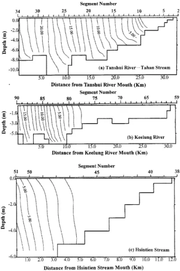
under mean flow condition. The model was run for one-year duration (705 tidal cycles). Figure 3 presents the predicted salinity distributions averaged over 2 spring-neap cycles (i.e., 58 tidal cycles) in the Tanshui River-Tahan Stream, Keelung River and Hsintien Stream. The limit of salt intrusion is rep-resented by the 1 ppt isohaline. Signification stratification occurs only in the first 10 km at the downstream end of the Tanshui River, since estuarine circulation occurs only in deep water at this reach of the river under mean flow conditions. The residual circulation tends to be strongest in deep section of the estuary and in the region where the salinity gradient is largest. The limits of salt intrusion are located at the Chung-Ilsin Bridge in the Tahan Stream and 6 km from the Keelung River mouth. There is barely any salt intrusion in the Hsintien Stream.
Another model simulation was conducted using the Q7, flow condition (Q,his the annually flow that is equaled or exceeded 75% of time). Q7, discharges at the tidal upstream limits of the three major tributaries are 8.15 m3/s, 20.2 m3/s and 3.61 m31s for Tahan Stream, Hsintien Stream, and
Kee-lung River, respectively. The 25 ppt salinity at the Tanshui River mouth was used for boundary condition, the same as the mean flow simulation in order to investigate the effects of different freshwater discharges. The model was run for one-year (705 tidal cycles). Figure 4 presents the average sa-linity distribution over 2 spring-neap cycles (i.e., 58 tidal
cy-cles) in the Tanshui River-Tahan Stream, Keelung River, and Hsintien Stream. The limits of salt intrusion are located at the Hsin-Hai Bridge in the Tahan Stream, 11 km from the Keelung River mouth, and 4 km from the Hsintein Stream mouth. The extensive intrusion of saline water introduces a significant baroclinic forcing and induces a strong residual circulatory system in the estuary.
Comparing figures 3 and 4, it is clear that higher river flow (mean flow) pushes the limits of salt intrusion farther down-river than low flow (Q72) condition. With a weakening of the
river flow, tidal action becomes more dominant and induces more mixing of salt and freshwater over the water column. However, the increased baroclinic circulation not only force the more saline bottom water upriver but also increases ver-tical stratification. The balance between tidal mixing and baroclinic circulation ultimately determines vertical salinity structures, which vary from location to location. River dis-charge is a dominant factor in determining salinity distri-bution.
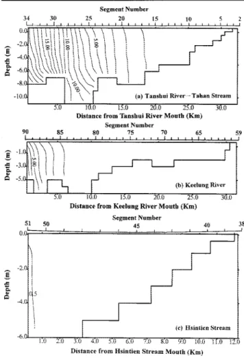
Segment Number
Distance from Tanshni River Month (Km) Segment Number 90 85 80 75 70 65 f .. [ I ,. . . ... .... 0.0 59
1\'
[| (b) l Keelung RiverE
5:0 1 .0 IS.0 20.0 25.0 30.0Distance from Keelung River Mouth (Km) Segment Number 51 50 45 40 3:
-2.0~~~~~~~~~~~~~~~~~~~~~~-(45 -4.0 (c) llsintien Stream -6.0 ) 2.0 3Q 4. .0 60 7.0 8:0 9.0 11.0 1(.0 h12iDistance from Hsintien Stream Mouth (Km)
Figure 3. Calculated salinity distributions averaged over 58 tidal cycles under mean flow conditions (a) Tanshui River-Tahan Stream (b) Keelung River (c) Hsintien Stream. (Numbers on the contours refer to the salinity
in parts per thousand)
Figure 5 presents the time series surface elevation and sa-linity under mean and Q7, flow conditions. Salinity shows a
strong periodic fluctuation in response to tide, with high stratification at low tide and nearly well-mixed at high tide. Baroclinic circulation enhances the vertical velocity shear, in-creasing stratification by differential advection during ebb tide. Both the reduced differential advection and enhanced mixing during flood help to eliminate stratification. Net downstream advection counters upstream progression of salt water along the bottom of the estuary, and partially mixed conditions are attained.
Reduction of Freshwater Input
The model was also run with Q7, flows at upstream
boundaries while the lateral inflow from wastewater along the river (shown in Figure 1) was cut-off by sewage inter-ception systems which is being constructed. The diversion of a large amount of wastewater to the ocean outfall system will decrease the freshwater flow in the river. A detailed analysis of salinity distributions was made for two cases,
Journal of Coastal Research, Vol. 17, No. 3, 2001
548
6 ci
River Influence on Salinity Intrusion 34 30 Segment Number 25 20 15 _ E iI I I. I, I 5,1 iOU '5. M 20.0 25.0
Distance from Tanshul River Mouth (Kin)
Segment Number 90 85 80 75 70 65 f I,I t 1, , . , . £ I t . , , Ie . I . It 5 2 59 (b) Keelung River .,0 I0.0 15.0 20.k 25.0
Distance from Keelung River Mouth (KIm)
Jt0 40 M.0 6-0 7. 81 5 o 9.f O Distance from Hsintien Stream Mouth (Km)
Figure 4. Calculated salinity distributions averaged over 58 tidal. cveles under Q7, flow conditions (a Tanshui River-Tahan Stream eb) Keelung River .`c Hsintien Stream. (Numbers or. the contours refer to the salinity in parts per thousand 1
60%- and 100% wastewater diversion, respectively. Table 2 shows freshwater discharge imposed at upstream boundary
conditions and the lateral inflow from watershed below gauging stations and from wastewater. Figures 6 and 7 pre-sent the tidally-averaged salinity distributions under the two cases. Comparing with the simulation results without wastewater diversion r(shown in Figure 4), figures 6 and 7 show that salinity increases about 1-2 ppt in most part of the estuary as a result of wastewater diversion. However, the limits of salt intrusion move only slightly upriver even if the wastewater is totally cut-off. Inspection of the bathy-metric profile indicates that the limits of salt intrusion stay near the sills (i.e., where the river bottom rises rapidly in the upriver direction). The sills at the upriver ends play an important role to prevent further salt intrusion as fresh-water input diminishes.
Transient Response to High Freshwater Discharge
The Q5, measure was used as the base condition to inves-tigate the salinity response to a pulse of high freshwater
dis-3e.0 U t 0.0 0.5 10 Time (day) t 22.0 20.0 18.0 160 5 14.0 t' 12.0 1 10.0VI 8.0 6.0 '1.0 1.5 2.0 26.0 24.0 22.0 20.0 18.0 3 16.0 n, 14.0 , 12.0 I 10.0 tt Q.5 0 1.0 1.5 2.0 Time (day)
Figure 5. Time series surface elevation and salinity at Kuan-Du Bridge (a; mean flow condition (bl Q,, flow condition.
charge. The model was run
with
Q,
0 to attain an equilibrium state condition before a high freshwater pulse of two days duration was introduced. The Q,, flow at the tidal limits of the three major tributaries are17.6
m/3
,s. 44.5 m
3
,;s and 9.8
m
3i's
for the Tahan Stream. Hsintien Stream and Keelung River. respectively. Salinity at the Tanshui River mouth was set at 30 ppt. A simple sinusoidal (M2) tide with an amplitude equal to the mean at the Tanshui River mouth (111.2 cm' was used to force the hydrodynamic model. High freshwater discharge was imposed on the upstream boundaries of theTable 2. Freshwater discharges imposed at
lions and lateral inflow.
upstream boundarv
condi-Upstream Freshwater Qs Flow Condition
Discharge,Lateral Inflow cmn !s
Tahan Stream 8.15
Hsintien Stream 20.2
Keelung River 3.61
Lateral inflow from watershed 7.6
Lateral inflow from wastewater 20.63
Cut-off 60% wastewater 8.25
Cut-off 100% wastewater 0
Journal of Coastal Research. Vol. 17. No, 3, 2001
e. -2.0 E40 .C -8.0 -10.0 .T TaushuiRiver-TahanStream 549
Liu et al.
Segment Number
20 15
Distance from Tanshui River Mouth (Krm) Segment Number
85 80 75
Segment Number
20 15
Distance from Tanshui River Mouth (Km)
70 65 59
. I I ....I.... . :
5:0 10.0 I5.0 20.0 25.0
Distance from Keelung River Mouth (Km)
Segment Number
30.0
51 50 45 40 3
0.
I
-6 g > , .. A n > ^ r f . rS. P7 n n(e) Ilsintien Stream
-6.0 - - .
Distance from Keelung River Mouth (Km
38 S1 50
'i
:0 20 3.:U 4.0 5.0 6.0 1.0 S.0 5:0 10.0 11.0 12.0
Distance from Hsintien Stream Mouth (Km)
Figure 6. Calculated salinity distributions averaged over 58 tidal cycles with 60 percentage wastewater cut-off (a) Tanshui River-Tahan Stream 'b) Keelung River (c) Hsintien Stream. (Numbers on the contours refer to the salinity in parts per thousand)
Segment Number
45
1 1
-~~*~
\\~~
\\\
1
\~~\
\
\\
~(e)
fisintien
Stream
..6 _
i.u 2.U j.V -)t 1.U b.O, /.U -. 1.0 IU~
Distance from Ilsintien Stream Mouth (Km)
Figure 7. Calculated salinity distributions averaged over with total wastewater cut-off (a) Tanshui River-Tahar. S lung River (c) Ilsintien Stream. (Numbers on the contou salinity in parts per thousand)
U I -.t -Z.U
58 tidal cycles tream (bi Kee-rs refer to the
three major tributaries for two calendar days. Figure 8 pre-sents the time series salinity responses to the pulse of high freshwater discharge. Aftermath of high flow, salinity grad-ually recovers to its original condition in about 5, 9, and 7 days in the Tahan Stream, Hsintien Stream and Keelung River, respectively. These recovering times are quite different
from
the larger estuarine system, (e.g., the major tributary estuaries of the Chesapeake Bay, USA) which require an or-der of a month to recover to normal conditions (NICHOLS, 1993).Flushing Time
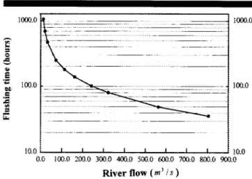
The estuarine flushing time was also estimated from a se-ries of model simulations. The flushing time is defined as the time taken to replace the existing fresh water in the estuary at a rate equal to the river discharge (DYER, 1973; OFFICER,
1976), i.e., Tf = F/R where F is the total volume of fresh water in the estuary at high water and R is the river discharge. The model simulations were performed for a range of river
dis-charge conditions. In this study, it is the flushing time of the entire tidal portion of the Tanshui River system we were in-vestigating, not just the portion of the river conforming to the strict definition of estuary (i.e. saline portion of the river). Therefore the total volume of freshwater in the entire model domain was calculated from model results of salinity distri-bution and river geometry. Figure 9 presents the estimated flushing time as a function of river discharge. The increase in river discharge is accompanied by a more rapid exchange of freshwater with the sea. The volume of fresh water accu-mulated in the estuary increases with a lesser extent than does the discharge. Thus the flushing time decreases with increasing river discharge.
Figure 9 shows that the flushing time varies between 36 to 1077 hours over the range of river discharge investigated, and is inversely related to river discharge. For river discharg-es above 12.2 m3/s, the flushing time is less than 1077 hours. For the very low river discharges, the flushing time increases
Journal of Coastal Research, Vol. 17, No. 3, 2001 =-41( , 1 _. = -6. -5.1 -I .= -3 ( 'O . ... . . I . I I . . . I.. . . . . . ( I I I
[\ F
1
-~~~J\\\
(hi Keelung Riv~~~eri
C. 40 338 i I 5S0River Influernce on Salinity Intrusion 1600.0 1000.0 1200.0 S M00. .~ 0 8Q.l -S E cm ._ I00.0 400.0 0.0 Julian day 16.0 4000 14.0 (b)
[Z2isIs(IT]
12.0 _ t 300.0 200.0 Z7 60 4k~~~~~~~~~~~~~~~~100.0
0.0 0.0 2420 244.0 246.0 248.0 250.0 252.0 254.0 256.0 Julian day 5.0 4.0 F ,c ,20 CI2.0 1.0 0.0 1500.0 Juiian davFigure S. Time series salimty response to the pulse of high freshwater discharge.
sharply but changes slowly at high river discharge, which is similar to the estimates given by KETCHUrM 11952).
CONCLUSIONS
A numerical model has been developed to study the hydro-dynamic characteristics and salinity distributions of a branched estuary in northern Taiwan. The model is a later-ally integrated, two-dimensional, real-time model. The model was applied to the Tanshui River estuary. and calibrated and
1000.0
100.0
10.0 ' I I I I ' I i I lz0.o
0.0 100.0 200.0 300.0 40W00 500.0 60.0 700.0 800.0 900.0
River
flow
(n3 is )Figure 9. Estimates of the flushing time of the estuary calculated for a range of river discharges.
verified with observed time series water level, current, and salinit.y data and spatial distributions of tidally-averaged sa-linity. Analyses were made of the computed salinity distri-butions under several seenarios of wastewater diversion and under various hydrological conditions to investigate their re-sponses to the amount of freshwater inflows in the Tanshui River estuanne system.
The magnitude of river discharge is the dominant factor affecting salinity intrusion in the estuary. Under mean flow conditions, sea water barely intrudes into the Hsintein Stream. Reduction of the river discharge to
Q
7 flow increasesthe extent of salt intrusion by 7 km, 5 km and 4 km in the Tahan Stream, Keelung River and Hsintein Stream, respec-tively.
Simulation of flow reduction with lateral inflow cut-off by sewage interception systems shows salinity increase over the entire estuary. The level of increase is 1 to 2 ppt under the
Q7, modeled condition. Salinity increase is expected to be more severe under lower flow conditions. Limits of salt intru-sion shift only slightly upriver in all branches of the river. Under low flow conditions, limits of salt intrusion are pri-marily control by river bathynetry at upriver ends.
The model was also used to investigate the salinity sponse to the pulse of high freshwater discharge. Salinity re-covers quickly to normal conditions in less than 5, 9. and 7 days for the Tanshui River-Tahan Stream, Hsintien Stream and Keelung River, respectively. The calculated system flush-ing time is strongly dependent on river flow and varies be-tween hours to an order of one month.
ACKNOWLEDGEMENTS
The project under which this study was conducted was sup-ported;, in part, by National Science Council, R.O.C., under grant No. 88-261:1-E-002-086 and 89-2213-E-002-075. The fi-nancial support in highly appreciated, The authors also like to express their appreciation to the two manuscript review-ers; though their comments and suggestions this paper was substantially improved.
Journal of Coastal Research, Vol. 1'. Nc. 3! 2001
552 Liu et at.
LITERATURE CITED
BLUMBERG, A. F., 1975. A numerical investigation into the dynamics of estuarine circulation. Chesapeake Bay Institute, Technical Re-port 91, The Johns Hopkins University, 59p.
BLUMBERG, A. F., 1977. Numerical tidal model of Chesapeake Bay.
Journal of the Hydraulic Division, ASCE, 103, 295-319.
BLUTMBERG, A. F., 1978. The influence of density variations on es-tuarine tides and circulation. Eses-tuarine and Coastal Marine
Sci-ence, 6, 209-215.
BOERICKE, R. R. and HOGAN, J. M., 1977. An x-z hydraulic/thermal model for estuarine. Journal of the Hydraulic Division, Proceedings
ASCE, 103(HY1), 19-37.
CHEN, Y. C. and HUNG, T. C., 1988. The behavior and mobilization of trace metals in the Tanshui River. Journal of the Environmental
Protection Society of the Republic of china, 11, 21-31. (in Chinese)
DEER, K. R.. 1973. Estuaries: A Physical Introduction. New York: Wiley, 140p.
EDINGER, J. E. and BUCIAK, E. M., 1981. Estuarine laterally av-eraged numerical dynamics: the development and testing of es-tuarine boundary conditions in the LARM code. Paper EL-81-9, Prepared by J. E. Edinger Associates Inc., for the U.S. Army En-gineering Waterways Experiment Station, CE, Vicksburg, Missis-sippi, 84p.
ELLIOTT, A. J., 1976. A numerical model of the internal circulation in a branching estuary. Chesapeake Bay Institute, Special Report
54, The Johns Hopkins University, 85p.
HAMILTON, P., 1975. A numerical model of the vertical circulation of tidal estuaries and its application to the Rotterdam Waterway.
Journal of Geophysical Research, Astronomy Society, 40, 1-21.
HAMILTON, P., 1977. On the numerical formation of a time depen-dent multi-level model of an estuary, with particular reference to boundary conditions. In: WILEY, M. (Editor): Estuarine Processes:
Volume II Circulation, Sediment and Transfer of Material in the Estuary. New York: Academic Press Inc, 347-364.
Hsu, M. H.; Kuo. A. Y.; Kuo, J. T., and LIu, W. C., 1996, 1997. Study of tidal characteristics, estuarine circulation and salinity distribution in Tanshui River system (1), (2). Technical Report No. 239 and 273, Hydrotech Research Institute. National Taiwan Uni-versity, Taipei, Taiwan, 245p. (in Chinese)
Hsu, M. H.; Kuo, A. Y.; Kuo, J. T., and Liu, W. C., 1999. Procedure to calibrate and verify numerical models of estuarine hydrodynam-ics. Journal of the Hydraulic Engineering, ASCE, 125, 166-182. JOHNSON, B. H., 1981. A review of numerical reservoir
hydrodynam-ic modeling. Technhydrodynam-ical Report E-81-2, U.S. Army Waterways Ex-periment Station, Hydraulic Laboratory, Vicksburg, Mississippi, 41p.
KETCHUM, B. H., 1952. Circulation in estuaries. Proceedings 3rd Conference Coastal Engineering, 65-76.
Kuo, A. Y.; NICHOLS, M., and LEWIS, J., 1978. Modeling sediment movement in the turbidity maximum of an estuary. Bulletin 111, Virginia Water Resources Research Center, Virginia Polytechnic
Institute and State University, Blacksburg, Virginia, 76p. NIcHOLS, M., 1993. Response of coastal plain estuaries to episodic
events in the Chesapeake Bay region. In: MEHTA, A. (Editor):
Nearshore and Estuarine Cohesive Sediment Transport. New York:
Springer-Verlag, 1-20.
OFFICER, C. B., 1976. Physical Oceanography of Estuaries (and
As-sociated Coastal Waters). New York: Wiley, 465p.
PERRELS, P. A. J. and KARELSE, M., 1981. A two-dimensional lat-erally averaged model for salt intrusion in estuaries. In: FISHER, H. B. (Editor): Transport Models for Inland and Coastal Waters. San Diego: Academic Press, 483-535.
RAO, A. D., 1995. A numerical modelling study of the flow and sa-linity structures in the Godavari estuary, east coast of India.
In-ternational Journal for Numerical Methods in Fluids, 21, 35-48.
WA.NG, D. P. and KRAVITZ, D. W., 1980. A semi-implicit two-dimen-sional model of estuarine circulation. Journal of Physical
Ocean-ography, 10, 441-451.
Journal of Coastal Research, NVol. 17, No. 3, 2001
Liu et al. 552