Impacts on the downstream river ecology
and bed evolution by the flood discharge
and sediment releasing of Shihmen
Reservoir
Yu-Hsiung Hsu, Ying-Sung Hsu, Chang-Hung Hsieh, Tung-Chou Hsieh, Chin-Yun Hsiao and Tsou-Joey Jaw
Abstract
This study explored the background information of Shihmen Reservoir, and collecting data included water quality, ecology, particle, and so on. It expected to promote sustainable development of operation of Shihmen Reservoir.
The oxidation-reduction potential might be directly related to the clam’s habitat. However more studies are needed to support this findings.
In addition, we used CCHE model to analysis the influence of river channel change. The first result showed that the growth of Wazihwei sand spit during typhoon was caused by backflow. Besides, the secondary sediment release could discharge about 1.33 million tons of sediment. Moreover, if the sediment release operations correspond with tide period cycles, it could reduce sediment deposition in the channel and take sediment farther even to the ocean.
Keywords: Shihmen Reservoir, Tamsui River, Drain, Sediment Releasing, Numerical Model, CCHE, Clam
1 Introduction
Since the Shihmen Reservoir began to store water in May 1963, it has shouldered the important task of supplying water resources in the northern region. The Shihmen Reservoir operated the reservoir during the typhoon to maintain the safety of the reservoir and achieve the goal of sustainable development of water resources. In recent years, the reservoir has implemented an update and improvement plan, the completion of the renovation of the sand-discharging tunnel, the anti-silting tunnel is being promoted, etc., and the reservoir is moving towards the goal of sustainable water resources. Therefore, in the operation of Shihmen Reservoir, this report continuously monitors and masters the relationship with downstream water quality and ecology, and influences the influences and changes of Dahan River and Tamsui River in the lower reaches of Shihmen Reservoir to facilitate the downstream ecological environment and estuary topography. It is easy to accumulate river sections and sands in various river sections, and effectively clarify the correlation with downstream ecological events and eliminate doubts from all walks of life.
2 Research Method
This study first conducts indicator bio-investigation and analysis. It is expected to help accumulate the relevant ecological background data of Shihmen Reservoir, and use CCHE 1D, CCHE 2D and CCHE 2D-Coast as the analytical and evaluation of the moving bed digital model tool. Taking the historical typhoon and flood disasters incident as the simulation condition, combined with the adjustment of the completed Zhongzhuang adjustment pool in recent years, the paper discusses and understands the influence of the reservoir silt on the downstream channel of the Shihmen Reservoir after the flood discharge and siltation to the river.
2.1 Indicator Biological Survey
The indicator organisms of this study, clam, were set up for investigation at three stations (Tamsui, Bali, Mangrove). The survey time was from June to September 2018, monthly. The measurement of oxidation-reduction potential was also carried out at the survey site to observe the quality of the clam habitat. The survey method was to use pH/ORP meter, and the platinum electrode was directly inserted into the subsoil 2~3cm for measurement, 30~60 seconds. The data can be read after the value is stable.
2.2 CCHE 2D two-dimensional river channel model simulation conditions
To understand the changes of the sedimentation and sedimentation of the downstream river bed after the operation of the Zhongzhuang adjustment pool, the downstream river channel is divided into four places to simulate the relative positions of the river sections. The impact of river channel erosion and deposition changes, using parameters and boundary conditions as shown in Tab.1 Taking typhoon Soulik as the basic condition, and repeating the second sand discharging operation twice, to explore the change behavior of the bottom bed in the lower reaches of Shihmen Reservoir after the start of the water supply for the Zhongzhuang adjustment pool.
Tab.1: Simulation location parameter setting summary table Simulation
location
Manning
coefficient Upstream boundary Downstream boundary
A 0.042 Shihmen Reservoir measured flow rate, mud and sand volume calendar
Wuling Bridge water level simulation results (CCHE1D)
B 0.038 Kite Mountain weir flow, silt volume simulation results (CCHE1D)
Sanying Bridge water level simulation results (CCHE1D) C Dahan River: 0.038 Three Gorges River: 0.035
Ganyuan Bridge Flow and Mud Volume Simulation Results (CCHE1D)
Three Gorges (2) Station measured flow, mud and sand volume line
Chenglin Bridge water level Simulation results (CCHE1D)
D
Dahan River: 0.042 Xindian River:
0.038
Xinhai Bridge flow, mud and sand simulation results (CCHE1D)
Xiulang station measured flow, mud and sand calendar
Taipei Bridge water level simulation results (CCHE1D)
2.3 CCHE 2D-Coast two-dimensional
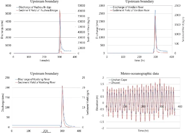
The estuary model simulation condition is to understand the change of the sedimentation and sedimentation concentration of the Tamsui estuary bed after the operation of the Zhongzhuang adjustment pool. This case is started at 0:00 on July 4, 2013 and 0:00 on July 12, 2013. The case, and then join the hydrological related data of the typhoon Soulik of 01:00 on July 12, 2013 to 11:00 on July 19, 2013. The case boundary and parameter settings are shown in Abb. 1.
Upstream boundary Upstream boundary
Upstream boundary Meteo-oceanographic data
Abb. 1: Estuary 2D case boundary
3 Research Result
3.1 Indicator biometrics survey results
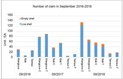
Take the 2016-2018 September clam survey as an example. The number of clam in Mangrove and Bali in 2018 is much higher than that of 2016 and 2017. However, the number of clam in the Tamsui River estuary has not grown in 3 years, and there are less than 50. According to the survey results, the oxidation-reduction potential of Tamsui
estuary (-112mV and -373 mV) is significantly different from that of Bali and Mangrove. According to the literature, this result indicates that the quality of the habitat in the Tamsui estuary is poor. The factors affecting the oxidation-reduction potential include the composition of temperature and river water quality, among which the pH value is more obvious, and there is no direct correlation with sediment yield and sediment transport in the basin.
Abb. 2: Comparison of clams and calendar year (September 2016~2018) Tab. 2: Oxidation-reduction potential of each test station
Test
station Bali C Bali T Tamsui C Tamsui T Mangrove C Mangrove T Value
(mv) 165 201 -112 -373 128 131
3.2 CCHE 2D two-dimensional channel model simulation results
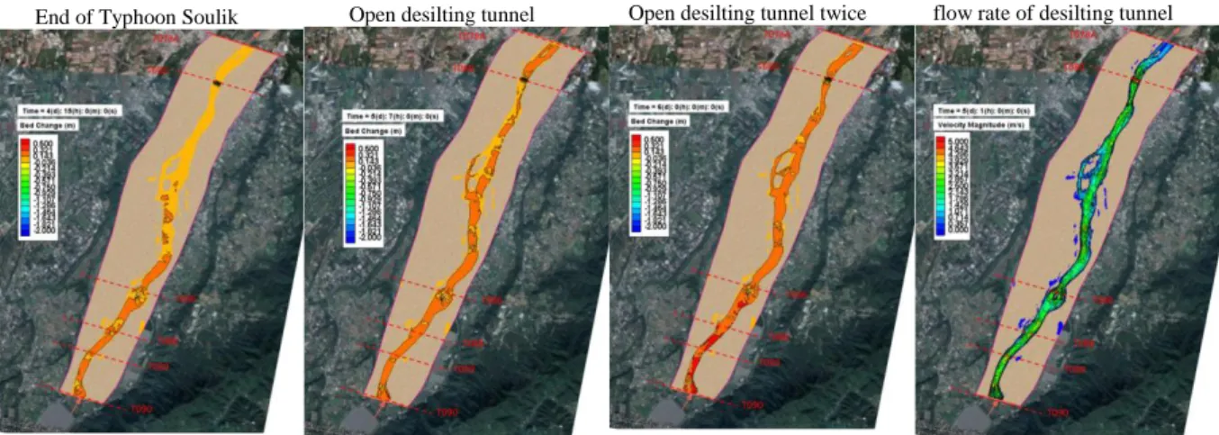
In the one-dimensional channel model, Abb. 3 is the change of the bottom channel of the main channel of Dahan River, according to the simulation results shown bed degradation action occurred at the Wuling Bridge, National Freeway No.3 Bridge and Sanying Bridge, and it was silted up in the deep trough downstream. According to the simulation results, after the end of typhoon Soulik flood peak (primary sand discharge), the bottom bed is brushed at 0.035 meters under the bottom pool (section T90A), and only the desilting tunnel and the drainage tunnel are opened during the secondary sand discharge operation. Therefore, the flow rate through the back pool is only 734 cms, so the mud sand can’t be carried to a large amount of silt to the downstream passage, and most of the silt occurs at the section T90A~T072. If, after the end of typhoon Soulik, two more desilting tunnels are opened for sediment discharge, the amount of mud sand can be reduced by about 1.33 million tons. However, since the flow rate of the rear pool is only 734 cms, the mud sand can’t be carried to a large amount of silt to the downstream section, and the silt still occurs at the section T90A~T072. In the two-dimensional channel model, taking the A area
(Houchiyan to Wuling Bridge,Abb. 4) as an example, it can be found that at the end of the actual situation of the typhoon Soulik, most of the silt is deposited in the T090A to T089 section. Up to 0.2m, the sedimentation volume of the downstream river channel is about 0.1~0.12m; after opening the desilting tunnel after the typhoon Soulik, the flow rate is only 734cms and the flow rate is only 4.2m/s, so only The sediment between T090A and T089 is sediment by the downstream of the water flow belt, and the sedimentation amount is about 0.2m high. The sediment deposition range between T090A and T089 is slightly expanded, and the sedimentation amount is 0.23m. There is no significant change in the sedimentation volume of the downstream river. After the desilting tunnels were opened twice after the typhoon Soulik, the sediment was mostly deposited between the T090A and T089 sections, and the sedimentation amount was as high as 0.35 m.
Abb. 3: Bed elevation change of Dahan River (Sediment transport formula: Wu)
End of Typhoon Soulik Open desilting tunnel Open desilting tunnel twice flow rate of desilting tunnel
3.3 CCHE 2D-Coast two-dimensional estuary model simulation results
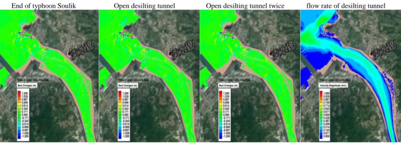
The simulation results of Abb. 5 Tamsui estuary can be found at the end of the actual situation of the typhoon Soulik, and the situation of scouring and silting is observed at the T000 section. The siltation and the lower brush are between 0.8~-0.8m, most of the silt fell between 2,000m outside the section T000, and the sedimentation amount was about 0.6~0.8m. After the desilting tunnel was opened after the typhoon Soulik, the flow rate at the Guandu Bridge was only 0.4m/s, and the sediment that can be carried is not enough, and the sedimentation range is only slightly expanded. After the desilting tunnels are opened twice after the typhoon Soulik, the sediment volume of 2,000 m outside the section T000 increases, but it is still limited.
End of typhoon Soulik Open desilting tunnel Open desilting tunnel twice flow rate of desilting tunnel
Abb. 5: CCHE 2D-Coast two-dimensional estuary model simulation results
4 Conclusions
Comparing the abundance of clam survey in 2018 with the same quarter of the past (2016, 2017), the results show that the Mangrove and Bali stations in 2018 are higher than the previous two years, and the Tamsui stations are not much different. Too low an oxidation-reduction potential can lead to anaerobic reactions and the formation of potentially toxic substances, resulting in poor habitats and reduced populations. The relative Mangrove and Bali are increasing due to the better quality of the habitat. The discharge of industrial or urban waste water in the middle and lower reaches of the Tamsui River leads to a decrease in the pH value of the river downstream and the estuary, which may be an important factor affecting the habitat of the scorpion.
In this study, the typhoon Soulik was used as the basic condition to discuss the change behavior of the bottom bed in the lower reaches of Shihmen Reservoir when the water supply for the Zhongzhuang adjustment pool was started, and the second sand discharging operation was repeated twice. The results showed that the amount of mud sand could be discharged more. 1.33 million tons. According to the simulation results, the influence of the secondary sand discharge on the bottom bed ranged from the downstream of the back pool to the inlaid bridge, which increased the sedimentation amount of 0.1~0.2 m
compared with the case of the typhoon Soulik; while the rest of the area was only 734 cms due to the upstream flow. Therefore, the amount of bed change in the remaining areas is not significant. The change of the bottom bed of the estuary section depends on the flood peak amount of the Shihmen Reservoir flood discharge. The opening of the desilting tunnel has little effect on the change behavior of the bottom bed at the estuary.
According to the data, the flood discharge and siltation operation of Shihmen Reservoir can cooperate with the fluctuation of the downstream tidal level, and the sand discharge operation during the low tide period can reduce the sedimentation amount of the muddy sand in the river channel, and the mud sand can be further brought to the outer sea with the flood.
References
Hung-Yee Chen, Yun-Dar Ho (2003). Effects of different temperature on growth and survival of hard clams, MARICULT. RES., 1(2): 17-24.
Yao-Xin Zhang (2005). CCHE2D-GUI-Graphical User Interface for the CCHE2D Model User’s Mannual-Version 2.2, NCCHE Technical Report No. NCCHE-TR-2005-03.
An-Guo Zhang et al. (2015). Effects of temperature, salinity and sediment on the burrowing behavior of clam (Meretrix meretrix), Chinese Journal of Ecology, 34(6): 1595-1601.
Feng Chia University (2016). Planning of the Response of River Channel Stabilizing and Sediment Management for the Danshuei River (3/3), the 10th River Management Office, WRA, Banciao, 1st ed. 2016.
Sinotech Engineering Consultants, LTD (2017). Desilting Operation of 2nd Nan-Hua Reservoir and Rehabilitation Planning of Eco-Environment in Hoku Creek, Water Resources Planning Institute, WRA, MOEA, Taichung, 1st ed. 2017.
Authors (Text style: Authors Address)
Yu-Hsiung Hsu Ying-Sung Hsu Chang-Hung Hsieh Tung-Chou Hsieh Chin-Yun Hsiao Tsou-Joey Jaw
Department of Water Resources Engineering, Feng Chia University (FCU), Taiwan Email: [email protected]