Location-Aware Indoor Emergency Navigation System
1Chih-Feng Chao,
2Kun-Chieh Cheng, and
3Ying-Hong Wang
1
Dept. Of Computer Science and Information Engineering
2Dept. Of Information Management
National Pingtung Institute of Commerce, Taiwan 900, R.O.C.
3Dept. Of Computer Science and Information Engineering
Tamkang University, Tamsui, Taipei County, Taiwan 251, R.O.C.
E-mail: [email protected];[email protected];[email protected]
Abstract
-In this paper, a location-aware indooremergency navigation system is proposed. When any user carrying a mobile device provided with RFID reader enters an indoor environment that is installed in advance with RFID tags of the navigation system, the mobile device will automatically detect the system and download a map of escaping routes onto the device beforehand. When emergency events occur, the mobile device could immediately identify users’ locations by reading RFID tags and establish escaping routes. People could safely avoid hazardous areas while escaping from emergency and disasters like fire and earthquakes through the guidance of the mobile device. With the aid of this system, personal safety against accidents will be better ensured to achieve the objective of minimal casualties.
Keywords: Emergency navigation system, GPS,
Location-aware services, RFID, Sensors.
1. Introduction
The location-aware system can be adopted many ways to get the user’s position. For example: Radio Frequency Identification (RFID), Global Positioning System(GPS)[1], etc.
In the location-aware system, the definition of the position is users, the device, and the resource. In accordance with the administrative information provided by the position, users are able to apply the relevant personal service via accessing the related administrative information system. For example; the service of guidance and location can construct the Mobile Service through mobile devices and sensors.
The globalization and population of Mobile Service has brought much convenience so far. The rapid development of the size of Mobile telecom communication devices has become smaller and
smaller. Users can bring mobile devices everywhere and access information. However, these devices have their limitation, such as the battery, the Operation ability and the screen size.
The attribute of mobile devices including mobility, portability and speedy established of wireless environment make the information ubiquitous, even anytime and anywhere. Not only can it break the restriction that people only use desktop computers to surf Internet, but people can bring the mobile devices to access the information where they need. Because of these reasons, mobile devices make mobile operation more popular.
Nowadays, even refrigerator, televisions, radios and public telephone, etc., in our life are able to connect to Internet, and have the operating ability. When substance around people can connect to Internet, it becomes more convenient and easier to get the information. People can create the environment that Internet is ubiquitous through using mobile devices or other things mentioned above being online.
The architecture of this paper is as following: Section 2 will give a related work of the RFID technology. Section 3 will discuss that the system architecture of location-aware emergency navigation system including system platform architecture, User Mobile Platform and Mobile Devices Network Procedure. Section 4 is system prototype and last section is conclusion.
1.1 Motivation
GPS is used most common by using outdoor location system. People can use GPS to get their current position outside. But the satellite signal of GPS will be hidden by building and cause that it can’t calculate position correctly in the indoor environment [2]. In order to solve GPS not to locate in the indoor, we have to focus on applying the relevant indoor locating research.
The relevant researches of indoor locating system are more and more mature [3, 4, 5]. The location awareness especially if the indoor location technology can apply in the emergent situation. It also becomes tremendously important for people who are in the disaster. In another word, people who are in the disaster do not have any idea of the exact position in the emergency environment. When the emergency occurs, they go blindly or so nervous too calm down. They can only follow people’s running or rely on their weak memory of this indoor environment to search the exit. It maybe waste much time and couldn’t search the exit correctly right away.
Tsai [6] pointed out the wrong escaping way to people in 2004 as listed below several items. 1. Escape to the original entering path:When
emergency occurs, they only have to rely on their weak memory of the original entering path to escape in an unfamiliar environment. 2. Escape to light:Escaping to light accordingly
could cause to be more dangerous because the light maybe a hole of high place in the building or a disaster place.
3. Following path blindly:Following someone’s running doesn’t mean the path is safe exit. 4. Jumping down to the floor insecurely:Because
people’s terror of fire, someone will choose this way. However jumping down to the floor will cause suicide or make first aider annoy.
If they have slim mobile devices to detect where users are and use the location-aware emergency navigation system to find the exit, not only can they clearly know the indoor environment, but people can realize the exact position in it. If they get lost, the location-aware emergency navigation installed in mobile devices can help people to find the correct location and exit.
2. Related Work
RFID which has aroused the attention in the recent years is the mainstream of techniques of related indoor location navigation system. Our study uses RFID develop location-aware indoor emergency navigation system. The advantages of RFID in the rapid development, population, the low unit-price and the convenience of deployment make the technology widely apply in many fields.
RFID can use radio frequency identify object and access data automatically. It has applied in many fields widely for many years. RFID typically contains two main object, RFID reader and RFID tags. Communication between the RFID reader
and tags occurs wirelessly and contactless. It means RFID doesn't require a line of sight between the devices. Even RFID can identify users’ information and users' mobile device IP [7]. RFID tags come in two general varieties: Active RFID tags and Passive RFID tags. As what Table 1 depicts.
Active RFID tags are powered by their own internal battery. Unlike active RFID tags, Passive RFID tags operate without a separate external power source and obtain operating power generated from the reader. Passive tags are consequently much lighter than active tags.
RFID systems have their some different frequency ranges. They are Low-frequency (LF), High-frequency (HF), Ultrahigh-frequency (UHF) and Microware frequency (MWF). Low-frequency (30 KHz to 500 KHz) systems have short reading ranges and lower costs. High-frequency (13.56 MHz) is used to provide ranges of 10cm~1m and just cost more a little bit expensive than LF. Ultrahigh-frequency (850 MHz to 950 MHz) and Microwave frequency (2.4GHz) usually offer long ranges and high reading speeds such applications as car tracking and automated toll collection. However UHF and MWF incur higher costs.
Nowadays, RFID High-frequency at 13.56MHz has the common ISO standard including ISO 14443 Proximity Coupling Smart Cards and ISO 15693 Vicinity Coupling Smart Cards [8,9]. The read distance of ISO 14443 is about in 10cm and the read distance of ISO 15693 is about in 1m.
Lionel M. Ni [10] pointed out: Indoor Location Identification based on Dynamic Active RFID Calibration, LANDARC in 2003. It proves that using RFID technology on location-aware indoor navigation system is workable.
Because an active RFID tag will cost more than a passive RFID tag, we choose the passive RFID tag base on cost effective. In order to make users’ mobile devices not limited to receiving the signal in short distance, we choose 13.56 MHz High-frequency with ISO 15693 RFID tag which read distances about 1m. This research uses the Table 1. The contrast between active and passive tags
Active Tags Passive Tags Power Embedded
In Battery
Backscattering The Carrier Wave From
The Reader Read
Distances
May Reach About 30m
May Reach About 1~5m
specification like Table 2.
3. System Architecture
The indoor emergency navigation system will have to put RFID tags in an indoor environment. We estimate that per one square meters of building floor space will embed with one RFID tag and measure its position precisely.
The interior of the RFID tag has the Uniform Identification (UID). We use the UID to become map grid which auto downloads to mobile devices. When Mobile devices with RFID Reader are nearby RFID tags, it can sense UID which is for reference map grid via the middleware of the system assistance. Then help escaper guide to exit.
If In an emergency occurs, the escaper just use mobile devices sense RFID tags which are near the person. Then the Application Program Interface (API) of the mobile devices will run to operate the shortest path that guide escaper to exit.
In order to prevent emergency occurs, this environment is filling in thick fog or invisible light, the top of every passive RFID tag has a luminous or LED device. The motivation is that escaper can see where RFID tags are and sense them.
This system architecture has two parts. The first part is about system platform architecture. This part is including server operation procedure and User mobile platform.
In system platform architecture, server is the main engine to provide map files for mobile devices in the indoor emergency navigation system. So server operation procedure shows that server plays what kind of role and the procedure of how to operate. User mobile platform put the accent on the middleware and system platform of the user mobile device. This section shows them about structure explanation.
The second part is about user system architecture. This part is including mobile devices system and mobile devices network procedure. In the user system architecture, mobile devices system shows the four major parts, Mobile Hardware, Mobile System OS, middleware, RFID reader, and User Interface. Mobile devices network procedure shows the simple procedure of mobile devices how to connect network.
3.1 System Platform Architecture-Server
Operation Procedure
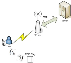
As what the Figure 1 depicts, it illustrates the process of the Indoor Emergency Navigation System. When users enter into the Indoor environment, the system will automatically download the indoor environment configuration map and deliver it to the user’s mobile devices.
The way what it downloads, server sends the indoor environment configuration map to the user’s mobile devices through wireless LAN AP.
When the mobile devices receive the map, it integrates with RFID Reader in the mobile devices, and detects RFID Tag of the current position for identifying map grid in the Indoor environment.
3.2 User Mobile Platform-Middleware
Middleware plays the intermediary role of the RFID Tag and the applications. When applications use a set of common Application Interface (API) provided by Middleware, it is able to connect REID Reader, and read the information of FRID Tag.
Even some problems occur such as that the corpus storing RFID tags or the server application is added, or substituted by other programs, or the types of RFID Reader increased can process without modification which can save complicated problems of maintenance on the system connection.
Otherwise, writing and maintaining programs will be a difficult task because the number of RFID Reader interface rises and so does the number of the application. We write the program of the Middleware is Microsoft C# 2005.Net. Table 2. RFID Specification
Property Passive Tags
Frequency HF 13.56 MHz ISO ISO 15693 WLAN Server User RFID Tag Map
3.3 User Mobile Platform-Mobile Devices
System Platform
The developmental operational system platform on the mobile devices was Windows Mobile. From the point of view of the development of the production, because Windows Mobile can handily develop in Windows Mobile Intelligent mobile devices platform with the same code, this can reduce the difficulty of third-party write cross-platform software.
Because of continuously using the interface of Microsoft Windows Operational System, the interface and the manipulation are really familiar with one in the Windows OS. For users, this is quite familiar and effortless. So our mobile devices OS use Windows Mobile.
3.4 User System Architecture
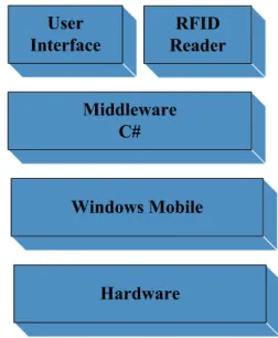
The mobile devices system platform like figure 2 illustrates the operational part of each item in the device. The function of the system platform provided four major parts by the mobile devices.
The first one is the Mobile Hardware, which is composed of the Mobile Hardware. For example, the monitor by which users read the information. The touch pad offered for users to point the information, and the slot of CF Type II provided for users to expand interface card. We inserted the RFID Reader into the mobile device; besides, the transmission by wireless Internet is provided for data transmission and Internet connection.
The second part is the Mobile System OS. The condition of the hardware in PDA is not superior to the one of PC; therefore, the capacity of data and the allocation of the system information become essential. Mobile devices save OS in Flash Rom and support 64~128MB ram memory.
So, not only can it utilize the storage space sufficiently, but it efficiently manages the mobile devices memory resource. The current system includes Microsoft Pocket PC, Windows Mobile and Embedded Linux. We use Windows Mobile.
The third part is Middleware, which is the nerve center of the RFID operation. This plays the intermediary role between RFID Tag and Application, which is one of the crucial factors manipulating the Indoor Emergency Navigation System successfully
The fourth part is User Interface and RFID Reader. User Interface launches the wireless electric wave, a contact-less way to read the UID on the Tag of matters for the identification and the retrieve of wireless data. This research use CF interface and RFID Reader to read RFID Tag constructed indoor environment.
User Interface designs the items that people are familiar with in the daily life into interface of the program. When users see the familiar interface, they can save lots of time to get accustomed to the interface and understand the function. The One-Touch is expected to use at this program for users to change the system screen rapidly.
3.5 Mobile Devices Network Procedure
First, users need to connect the server, and then, launch the request of downloading the map of the current indoor environment map via the wireless LAN. When the connection is constructed, the server will automatically provide the download of the map after receiving the users’ requests. As what figure 3 depicts.
The first step: Connect to Server
The second step: Via the wireless LAN and request Network–connection.
The third step: Construct the connection and automatically provide the map.
4. System Prototype
When users enter into an indoor environment, system will automatically download this indoor
User
Interface
RFID
Reader
Middleware
C#
Windows Mobile
Hardware
Figure 2. Mobile Devices System Platform.
2.
Server User
1.
3.
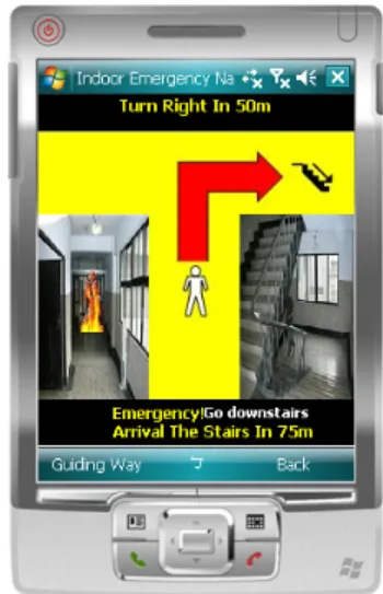
environment map files. As what Figure 4 depicts. If an emergency occurs, the gate is the exit nearest the escaper. The right side of the program will display Exit icon and Guide how many meters escaper should turn right or turn left. As following figure 5 depicts, the bottom of the program displays how many meters the Exit arrive. The left side of the program also shows that fire is happening.
When emergency occurs, escaper has to survive by going upstairs or going downstairs. At this time, system will decide that making a point of stairs is the safe area. When escaper’s safe exit is gate, program will display exit icon as following Figure 5.
When escaper’s safe exit is stairs, the right side of the program will display stairs icon and guide
how many meters escaper should turn right or turn left. By the way the bottom of the program will display how many meters the stairs arrive and guide escaper go upstairs or downstairs. The left side of the program displays that fire is happening. As what Figure 6 depicts.
5. Conclusion
The news of emergency disasters is frequently reported. Among all disasters, the highest rate of the occurrence is fire and the death toll keeps the certain number. Though the technique and the quality of building materials rise like fireproofing construction materials, these belong to passive safety and it can not actively protect people to be safe.
This research is expected to investigate the Indoor Emergency Navigation System with location awareness. For people’s personal security, the design of the system can protect people in the emergency disaster places and reduce people’s possibility of being dead or injured.
Acknowledgment
This work is supported in part by National Science Council of Taiwan (R.O.C.) under contract number NSC96-2218-E-251-002.
References
[1] http://www.gps.gov/
[2] V. Zeimpekis, G. Giaglis, and G. Lekakos, “A taxonomy of indoor and outdoor positioning techniques for mobile location services,” ACM SIGecom Exchanges, vol. 3, no. 4, pp. 19–27, 2003.
Figure 5. System Prototype-Exit Guiding. Figure 4. System Prototype-Map Downloading.
[3] J. Hightower and G. Borriello, “A Survey and Taxonomy of Location Sensing Systems for Ubiquitous Computing,” CSE 01-08-03, 2001.
[4] S. Manapure, H. Darabi, V. Patel and P. Banerjee, “A Comparative Study of Radio Frequency-Based Indoor Location Sensing Systems,” Networking, Sensing and Control, IEEE International Conference,Vol. 2, pp.1265-1270, 2004.
[5] M. Mauve, A. Widmer, and H. Hartenstein, “A survey on position-based routing in mobile ad hoc networks,” IEEE Network, vol. 15, NO.6, pp. 30-39, 2001.
[6] Yuen-Yung Tsai, “Using Wireless Sensor Networks for Indoor Security Monitoring and Emergency Navigating System”, Master’s thesis, National Chiao Tung University, Hsin-Chu, Taiwan, 2004
[7] W. Tsan-Pin, "Enhanced binary search with cut-through operation for anti-collision in RFID systems", IEEE Communications Letters, vol. 10, no. 4, pp. 236 – 238, April 2006.
[8] M. Bhuptani, and S. Moradpour. RFID Field Guide. Upper Saddle.River : Sun Microsystems., 2005.
[9] S. Garfinkel, and B. Rosenberg. RFID
Applications Security and Privacy.Westford:Addison Wesley, 2005.
[10] L. M. Ni, Y. Liu, Y. C. Lau and A. P. Patil, “LANDMARC: Indoor Location Sensing Using Active RFID,” Proceedings of the First IEEE International Conference on Pervasive Computing and Communications, pp.407- 415, 2003.