應用高空間與高時間分辨率之福爾摩沙二號衛星遙測影像
探討極區冰架崩解之機制 (I)
研究成果報告(精簡版)
計 畫 類 別 : 個別型 計 畫 編 號 : NSC 98-2116-M-006-012- 執 行 期 間 : 98 年 08 月 01 日至 99 年 07 月 31 日 執 行 單 位 : 國立成功大學地球科學系(所) 計 畫 主 持 人 : 劉正千 計畫參與人員: 碩士級-專任助理人員:張越程 碩士班研究生-兼任助理人員:邱耀勝 碩士班研究生-兼任助理人員:劉家成 碩士班研究生-兼任助理人員:鄭依凡 碩士班研究生-兼任助理人員:郭譯聰 碩士班研究生-兼任助理人員:林聖翔 碩士班研究生-兼任助理人員:陳彥穎 碩士班研究生-兼任助理人員:曾炳祐 碩士班研究生-兼任助理人員:鍾曉緯 報 告 附 件 : 出席國際會議研究心得報告及發表論文 處 理 方 式 : 本計畫可公開查詢 中 華 民 國 99 年 10 月 31 日1
行政院國家科學委員會補助專題研究計畫
成 果 報 告
□期中進度報告
應用高空間與高時間分辨率之福爾摩沙二號衛星遙測影像
探討極區冰架崩解之機制(I)
計畫類別: 個別型計畫 □整合型計畫
計畫編號:NSC 98-2116-M-006-012-
執行期間:98 年 8 月 1 日至 99 年 7 月 31 日
執行機構及系所:成功大學地球科學系
計畫主持人:劉正千
共同主持人:
計畫參與人員:張越程、郭譯聰、鄭依凡、劉家成、邱耀勝
成果報告類型(依經費核定清單規定繳交):精簡報告 □完整報告
本計畫除繳交成果報告外,另須繳交以下出國心得報告:
□赴國外出差或研習心得報告
□赴大陸地區出差或研習心得報告
出席國際學術會議心得報告
□國際合作研究計畫國外研究報告
處理方式:
除列管計畫及下列情形者外,得立即公開查詢
□涉及專利或其他智慧財產權,□一年□二年後可公開查
詢
中 華 民 國 99 年 10 月 30 日
2
摘 要
國際極區年(International Polar Year 2007-2008)的主要任務之一,是協調並 蒐集衛星在劇烈變化的極區環境中所獲取之各種資料。然而受到高度、刈幅、 以及指向能力的限制,高空間分辨率光學遙測衛星的操作仍侷限於一定的緯度 範圍。由台灣的國家太空中心所操控的福爾摩沙二號衛星(福衛二號)是全世 界第一枚運行在每日再訪軌道上的高空間分辨率光學遙測衛星。福衛二號搭載 了雙軸高扭矩反應輪,可以分別在沿軌±450與跨軌±450的兩個方向上進行指向 拍攝。此特性讓我們每天都可以獲取極區任何地方 2 公尺解析度的光學影像。 我們已經成功地展現了這些前所未有的福衛二號影像是極區研究非常寶貴而 重要的資料來源,例如全世界第一幅南極科學站的高空間分辨率光學衛星影 像,以及在最近南極威爾金冰架崩解事件中所揭露的許多詳細資訊。
本研究與美國冰雪資料中心(National Snow and Ice Data Center; NSIDC)合 作,運用高空間與高時間分辨率的福衛二號影像,共同探討極區冰架崩解事件 的 機 制 。 研 究 的 目 標 區 域 是 格 陵 蘭 三 大 冰 川 Upernavik , Helheim 和 Kangerdlugssuaq 的出海口附近。這些地區的福衛二號 level-2 影像由國家太空 中心提供,更高階的產品則由福衛二號影像自動處理系統產製。為確保詳細的 速度與渦度場可以由前後期的影像中推導出來,本研究發展了一個可以同時考 慮冰塊旋轉與平移效應的影像自動匹配模組。我們與 NSIDC 的首席科學家 Dr. Ted Scambos 密切合作,共同分析所有的福衛二號影像。本研究的最終目的是 運用高空間與高時間分辨率的福衛二號影像,建立極區冰架崩解發生的機制。 關鍵詞: 極區、冰架、追蹤浮冰、崩解、遙測、福爾摩沙二號衛星
3
A b s t r a c t
Coordinating and collecting satellite data of changing polar environments is one of the prime activities occurring during International Polar Year 2007-2008. Limited to their altitude, swath and pointing capability, however, the operation of optical satellites with high-spatial-resolution sensors is generally restricted to certain latitudes. Operated by the National Space Organization of Taiwan, Formosat-2 is the first satellite with a high-spatial-resolution sensor placed in a daily revisit orbit. Equipped with two-axes high torque reaction wheels, Formosat-2 is able to point not only to ±450 across track, but also to ±450 along track. This characteristic enables us to acquire the optical imagery with 2m resolution at any place in Polar Regions everyday. We have demonstrated that these unprecedented images are a very useful data source with immediate impact on the research of Polar Regions, such as the first space-borne high-spatial-resolution (2m) optical image of the Amundsen-Scott South Pole Station, and the details of recent Wilkins Ice Shelf disintegration event.
This research collaborates with the National Snow and Ice Data Center (NSIDC) to investigate the mechanism of ice shelf disintegration in Polar Regions using Formosat-2 high-spatial- and high-temporal-resolution imagery. The target areas of this research are the outlets of three glaciers in Greenland, namely Upernavik, Helheim, and Kangerdlugssuaq. The level-2 images of Polar Regions were produced by NSPO, and then the automatic Formosat-2 image processing system (F2-AIPS) were employed to produce the higher level products. To ensure the detailed velocity field and the vorticity field can be accurately mapped from the before- and after-event image pairs, we develop an automatic image coregistration module that is able to consider both the rotation and translation of ice floes. We work closely with the Chief Scientist, Dr. Ted Scambos, in NSIDC to analyze all Formosat-2 images. The ultimate goal is to come up with a detailed mechanism of ice shelf disintegration in Polar Regions using Formosat-2 high-spatial- and high-temporal-resolution imagery.
Keywords: Polar Regions, ice shelves, tracking floating ice, disintegration, remote sensing, Formosat-2.
4
T a b l e o f C o n t e n t s
摘要... 2 ABSTRACT... 3 TABLE OF CONTENTS... 4 CHAPTER 1. INTRODUCTION... 5CHAPTER 2. IMPROVED FAST NORMALIZED CROSS COEFFICIENT TECHNIQUE 6 2.1 Bisect the image to separate ice floes from water ...7
2.2 Filter ice floes based on an appropriate size range ...9
2.3 Create the mask for individual floe...9
2.4 Fill the holes of floe masks ...10
2.5 Dilate each mask to include the floe boundary...11
2.6 Prepare the subimage of individual floe ...11
2.7 Select the similar size of ice floes for matching ...11
2.8 Compare the cross coefficient of each matching ...11
2.9 Output the translation and rotation of best matching...12
CHAPTER 3. RESULTS ... 12
CHAPTER 4. CONCLUSIONS... 13
CHAPTER 5. REFERENCES... 13
5
Chapter 1. Introduction
Satellite imagery has been widely used for studying the changing polar environments, such as tracking the retreat of glaciers and mapping the movement of sea ice floes (Rapley et al. 2004). As the new platform, Formosat-2, is developed and operated for collecting polar imagery with high-spatiotemporal resolution, we are now able to observe more details and detect the subtle changes in the Polar Regions (Liu et al. 2008; Liu et al. 2009; Scambos et al. 2009). To coregister the time series of high-spatiotemporal images, however, also raises a new challenge in image processing. For the examples of tracking the retreat of Flask, Crane, Scar Inlet and Leppard Glaciers, some regional rotations are found in the pair of Formosat-2 high-spatiotemporal imagery, which cannot be addressed by the general technique of image registration . For the cases of mapping the movement of sea ice floes near Ward Hunt Ice Shelf, the simple translation assumption is not valid and the dynamic changes cannot be addressed by the general technique of image registration either (Buehner, Thompson, and Peterson 1997; Lepparanta, Sun, and Haapala 1998; Gladstone and Bigg 2002; Haarpaintner 2006; Thomas, Geiger, and Kambhamettu 2008). In this research, we propose an improved fast normalized cross coefficient technique (IFNCC) that is able to derive the translation and rotation vectors from the pair of Formosat-2 high-spatiotemporal imagery. These information enables us to gain a better understanding of the external force in the study area.
6
Chapter 2. Improved Fast Normalized Cross Coefficient Technique
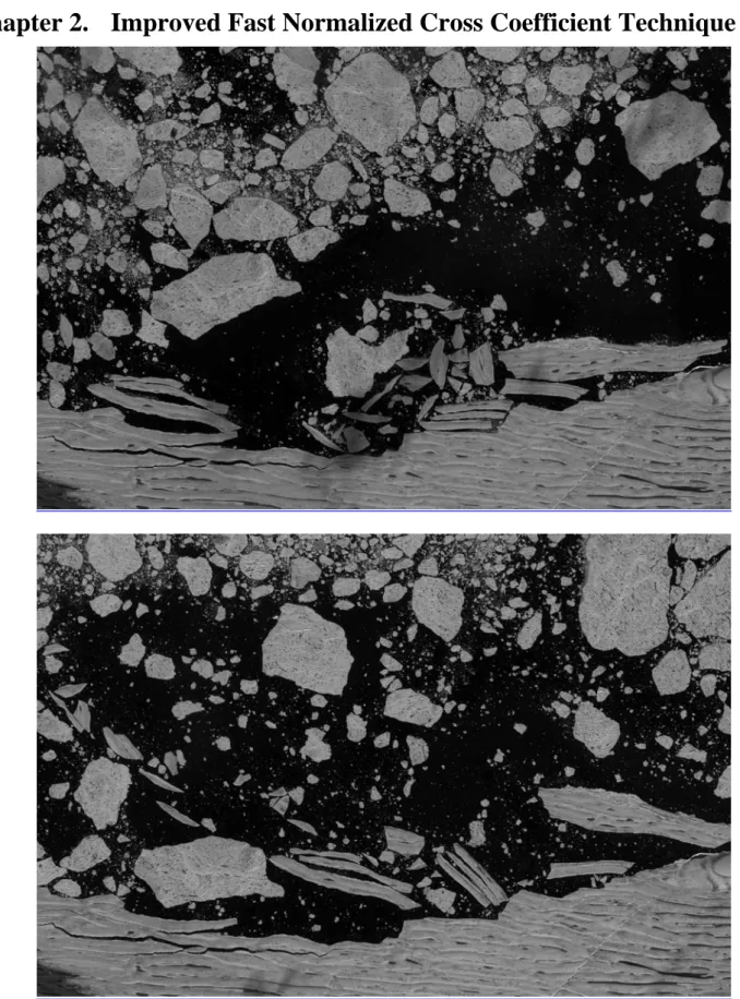
Figure 1. Formosat-2 image of Ward Hunt Ice Shelf taken on (a) 27 July 2008 and (b) 28 July 2008.
7
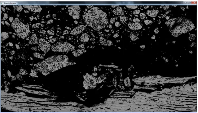
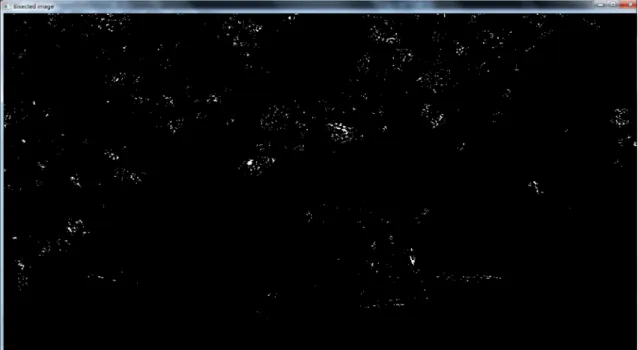
2.1 Bisect the image to separate ice floes from water
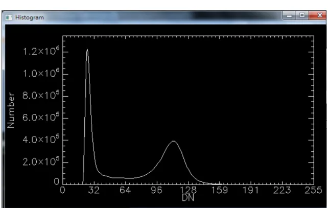
Figure 2. Hitogram for choosing the threshold for bisecting the image to separate ice floes from water.
8
Figure 4. Erode the image five times to create the clear cuts.
9
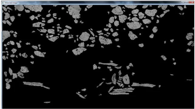
2.2 Filter ice floes based on an appropriate size range
Figure 6. Filter ice floes based on an appropriate size range.
2.3 Create the mask for individual floe
10
2.4 Fill the holes of floe masks
Figure 8. Label the holes of floe masks
11
2.5 Dilate each mask to include the floe boundary
Figure 10. Dilate each mask to include the floe boundary.
2.6 Prepare the subimage of individual floe
2.7 Select the similar size of ice floes for matching
2.8 Compare the cross coefficient of each matching
y x y x v u y x v u t v y u x t f y x f t v y u x t f y x f v u R , 2 , 2 , , , ] ) , ( [ ] ) , ( [ ] ) , ( ][ ) , ( [ ) , ( (1)12
2.9 Output the translation and rotation of best matching
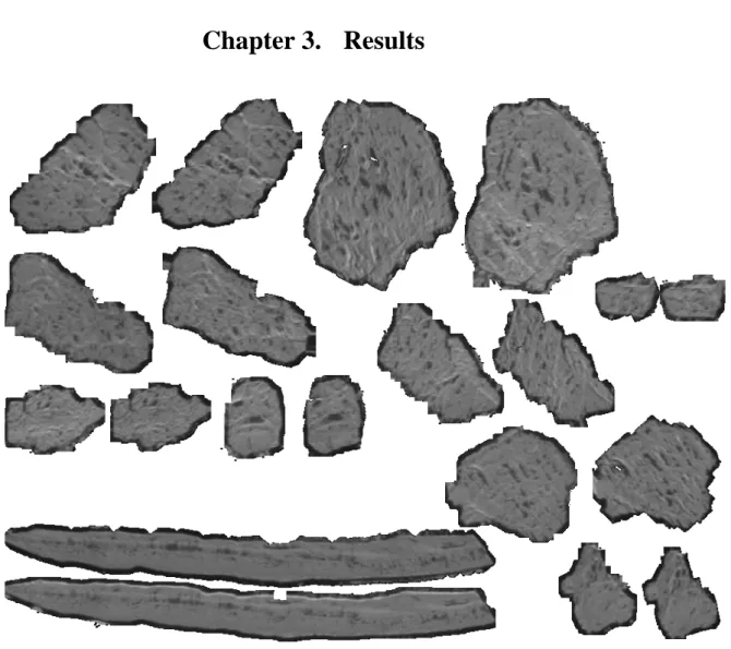
Chapter 3. Results
Figure 11. A few examples of calculating the rotation and translation of ice floes to get the best matches.
13
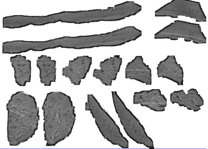
Figure 12. Other examples of calculating the rotation and translation of ice floes to get the best matches.
Chapter 4. Conclusions
In this research, we propose an improved fast normalized cross coefficient technique (IFNCC) that is able to derive the translation and rotation vectors from the pair of Formosat-2 high-spatiotemporal imagery. These information enables us to gain a better understanding of the external force in the study area.
Chapter 5. References
Buehner, M., K. R. Thompson, and I. Peterson. 1997. An inverse method for tracking ice motion in the marginal ice zone using sequential satellite images. Journal of Atmospheric and
Oceanic Technology 14 (6):1455-1466.
Gladstone, R., and G. R. Bigg. 2002. Satellite tracking of icebergs in the Weddell Sea. Antarctic
14
Haarpaintner, J. 2006. Arctic-wide operational sea ice drift from enhanced-resolution QuikScat/SeaWinds scatterometry and its validation. Ieee Transactions on Geoscience
and Remote Sensing 44 (1):102-107.
Lepparanta, M., Y. Sun, and J. Haapala. 1998. Comparisons of sea-ice velocity fields from ERS-1 SAR and a dynamic model. Journal of Glaciology 44 (147):248-262.
Liu, Cheng-Chien, Yueh-Cheng Chang, Stefani Huang, Frank Wu, An-Ming Wu, Soushi Kato, and Yasushi Yamaguchi. 2008. First space-borne high-spatial-resolution optical imagery of the Antarctic from Formosat-2. Antarctic Science 20 (6):605-606.
Liu, Cheng-Chien, Yueh-Cheng Chang, Stefani Huang, Sheng-Yun Yen, Frank Wu, An-Ming Wu, Soushi Kato, and Yasushi Yamaguchi. 2009. Monitoring the dynamics of ice shelf margins in Polar Regions with high-spatial- and high-temporal-resolution space-borne optical imagery. Cold Regions Science and Technology 55 (1):14-22.
Rapley, Chris, Robin Bell, Ian Allison, Robert Bindschadler, Gino Casassa, Steven Chown, Gerard Duhaime, Vladimir Kotlyakov, Michael Kuhn, Olav Orheim, Prem Chand Pandey, Hanne Kathrine Petersen, Henk Schalke, Werner Janoschek, Eduard Sarukhanian, and Zhanhai Zhang. 2004. A Framework for the International Polar Year 2007-2008. the ICSU IPY 2007-2008 Planning Group.
Scambos, Ted , Helen Amanda Fricker, Cheng-Chien Liu, Jennifer Bohlander, James Fastook, Aitbala Sargent, Robert Massom, and An-Ming Wu. 2009. Ice Shelf Disintegration by Plate Bending and Hydro-fracture: Satellite Observations and Model Results of the 2008 Wilkins Ice Shelf Break-ups. Earth and Planetary Science Letters 280 (1-4):51-60.
Thomas, M., C. A. Geiger, and C. Kambhamettu. 2008. High resolution (400 m) motion characterization of sea ice using ERS-1 SAR imagery. Cold Regions Science and
15
計 畫 成 果 自 評
本計畫之研究內容與原計畫相符。在本計畫執行期間,在國際知名的 SCI 期刊上共計 獲接受及已發表之論文有以下三篇,成果非常豐碩。
1. Liu, C.-C.*, Shieh, C.-L., Lin, J.-C. and Wu, A.-M. (2010) Classification of non-vegetated areas using Formosat-2 high spatiotemporal imagery: the case of Tseng-Wen Reservoir catchment area (Taiwan). International Journal of Remote Sensing. (accepted). (SCI) (NSC-98-2116-M-006-012), (NSC-98-2611-M-006-002), (MOEAWRA0950411), (Landmark project B-023).
2. Kao, S.-J.*, Dai, M., Selvaraj, K., Zhai, W., Cai, P., Chen, S.-N., Yang, J. Y. T., Liu, J.-T.,
Liu, C.-C. and Syvitski, J. P. M. (2010) Cyclone-driven deep sea injection of freshwater
and heat by hyperpycnal flow in the subtropics. Geophysical Research Letters. (accepted). (SCI)
3. Liu, C.-C.*, Kamei, A., Hsu, K.-H., Tsuchida, S., Huang, H.-M., Kato, S., Nakamura, R.
and Wu, A.-M. (2010) Vicarious Calibration of the Formosat-2 Remote Sensing
Instrument. IEEE Transactions on Geoscience and Remote Sensing. 48(4), pp. 2162-2169. (SCI) (NSC-98-2116-M-006-012), (NSC-98-2611-M-006-002), (Landmark project
1
國科會補助專題研究計畫項下出席國際學術會議心得報告
日期:99 年 10 月 30 日
一、參加會議經過
Dr. Cheng-Chien Liu, Professor of the Department of Earth Sciences and Institute of Satellite Informatics and Earth Environment, went to London and then to Leeds, UK, from 22 to 23 July 2010 to attend the 2010 Antarctic Peninsula Climate Change (APCC) workshop. This workshop includes presentations of recent climatological, oceanographic, environmental, and glaciological research in the Antarctic Peninsula. A primary objective of the meeting is to synthesize current knowledge and research on each of the Cryosphere, Atmosphere and
計畫編號 NSC 98-2116-M-006-012- 計畫名稱 應用高空間與高時間分辨率之福爾摩沙二號衛星遙測影像探討極區冰 架崩解之機制(I) 出國人員 姓名 劉正千 服務機構 及職稱 國立成功大學地球科學系 衛星資訊暨地球環境研究所教授 會議時間 22 July 2010 – 23 July 2010 會議地點 Leeds, UK 會議名稱 (中文) 2010 南極半島氣候變遷研討會
(英文) 2010 Antarctic Peninsula Climate Change Workshop
發表論文 題目
(中文) 運用改良式正規化交相關係數追蹤浮冰平移與旋轉
(英文) Tracking the translation and rotation of ice floes with improved fast normalized cross coefficient technique
2
projects. The paper entitled "Tracking the translation and rotation of ice floes with improved fast normalized cross coefficient technique" was reviewed and accepted by the committee. Therefore, the first author, Dr. Liu was able to give an oral presentation in the meeting.
3
Satellite imagery has been widely used for studying the changing polar environments, such as tracking the retreat of glaciers and mapping the movement of sea ice floes. As the new platform, Formosat-2, is developed and operated for collecting polar imagery with high-spatiotemporal resolution, we are now able to observe more details and detect the subtle changes in the Polar Regions. To coregister the time series of high-spatiotemporal images, however, also raises a new challenge in image processing. For the examples of tracking the retreat of Flask, Crane, Scar Inlet and Leppard Glaciers, some regional rotations are found in the pair of Formosat-2 high-spatiotemporal imagery, which cannot be addressed by the general technique of image registration. For the cases of mapping the movement of sea ice floes near Ward Hunt Ice Shelf, the simple translation assumption is not valid and the dynamic changes cannot be addressed by the general technique of image registration either. In this research, we propose an improved fast normalized cross coefficient technique (IFNCC) that is able to derive the translation and rotation vectors from the pair of Formosat-2 high-spatiotemporal imagery. These information enables us to gain a better understanding of the external force in the study area.
三、考察參觀活動(無是項活動者略) 四、建議
I was glad to meet several international collaborators. We all benefit from sharing experiences with each other during the meeting. Attending the international meeting is one of the most important methods to elevate our research level and link to the international researches.
五、攜回資料名稱及內容 Conference proceeding
國科會補助計畫 研發成果名稱 發明人 (創作人) 技術說明 技術移轉可行性及 預期效益 技術/產品應用範圍 產業別 計畫名稱: 計畫主持人: 計畫編號: 學門領域: (中文) (英文) 成果歸屬機構 (中文) (英文) 應用高空間與高時間分辨率之福爾摩沙二號衛星遙測影像探討極區冰架崩 解之機制 (I) 劉正千 98 -2116-M -006 -012 - 其他地球科學 應用高空間與高時間分辨率之福爾摩沙二號衛星遙測影像探討極區冰架崩解之 機制 (I)
Investigating the mechanism of ice shelf disintegration in Polar Regions with Formosat-2 high-spatial- and high-temporal-resolution imagery (I)
國立成功大學 劉正千
衛星影像已廣泛運用在研究極區巨變的環境,例如追蹤冰河的消退與海冰的移 動。由於福爾摩沙二號衛星可以對極區獲取高時空分辨率的遙測影像,我們現 在可以對極區做更深入、詳細的觀測。然而,要將這些時間序列的影像匹配關 連起來,是影像處理的一大挑戰。以追蹤Flask, Crane, Scar Inlet 和 Leppard Glaciers三大冰川為例,從福衛高時空分辨率的影像中發現了一些局 部性的旋轉現象, 是無法用一般影像匹配的方法來分析。再以追蹤Ward Hunt冰 架附近海冰的劇烈變動情形為例,一般海冰平移的假設也不再成立,同樣無法 用一般影像匹配的方法來分析。本研究中我們展了一種改良式正規化交相關係 數法(improved fast normalized cross coefficient technique; IFNCC), 可以同時追蹤浮冰平移與旋轉向量,這些訊息可以讓我們對研究區域所受到的 外力有更充分的了解。
Satellite imagery has been widely used for studying the changing polar environments, such as tracking the retreat of glaciers and mapping the movement of sea ice floes. In this research, we propose an improved fast normalized cross coefficient technique (IFNCC) that is able to derive the translation and rotation vectors from the pair of Formosat-2 high-spatiotemporal imagery. These information enables us to gain a better understanding of the external force in the study area.
其他專業、科學及技術服務業
可運用於處理高空間與高時間分辨率的福衛二號影像
可運用於其他相關影像處理之應用
計畫名稱:應用高空間與高時間分辨率之福爾摩沙二號衛星遙測影像探討極區冰架崩解之機制 (I) 量化 成果項目 實際已達成 數(被接受 或已發表) 預期總達成 數(含實際已 達成數) 本計畫實 際貢獻百 分比 單位 備 註 ( 質 化 說 明:如 數 個 計 畫 共 同 成 果、成 果 列 為 該 期 刊 之 封 面 故 事 ... 等) 期刊論文 0 0 100% 研究報告/技術報告 0 0 100% 研討會論文 0 0 100% 篇 論文著作 專書 0 0 100% 申請中件數 0 0 100% 專利 已獲得件數 0 0 100% 件 件數 0 0 100% 件 技術移轉 權利金 0 0 100% 千元 碩士生 8 8 100% 直 接 或 間 接 參 與 之碩士班研究生 博士生 0 0 100% 博士後研究員 0 0 100% 國內 參與計畫人力 (本國籍) 專任助理 1 1 100% 人次 碩士級研究助理 期刊論文 3 3 50% 數 個 計 畫 共 同 成 果 研究報告/技術報告 0 0 100% 研討會論文 0 0 100% 篇 論文著作 專書 0 0 100% 章/本 申請中件數 0 0 100% 專利 已獲得件數 0 0 100% 件 件數 0 0 100% 件 技術移轉 權利金 0 0 100% 千元 碩士生 0 0 100% 博士生 0 0 100% 博士後研究員 0 0 100% 國外 參與計畫人力 (外國籍) 專任助理 0 0 100% 人次
其他成果 (無法以量化表達之成 果如辦理學術活動、獲 得獎項、重要國際合 作、研究成果國際影響 力及其他協助產業技 術發展之具體效益事 項等,請以文字敘述填 列。)
movement of sea ice floes. As the new platform, Formosat-2, is developed and operated for collecting polar imagery with high-spatiotemporal resolution, we are now able to observe more details and detect the subtle changes in the Polar Regions. To coregister the time series of high-spatiotemporal images, however, also raises a new challenge in image processing. For the examples of tracking the retreat of Flask, Crane, Scar Inlet and Leppard Glaciers, some regional rotations are found in the pair of Formosat-2 high-spatiotemporal imagery, which cannot be addressed by the general technique of image registration. For the cases of mapping the movement of sea ice floes near Ward Hunt Ice Shelf, the simple translation assumption is not valid and the dynamic changes cannot be addressed by the general technique of image registration either. In this research, we propose an improved fast normalized cross coefficient technique (IFNCC) that is able to derive the translation and rotation vectors from the pair of Formosat-2 high-spatiotemporal imagery. These information enables us to gain a better understanding of the external force in the study area.
成果項目 量化 名稱或內容性質簡述 測驗工具(含質性與量性) 0 課程/模組 0 電腦及網路系統或工具 0 教材 0 舉辦之活動/競賽 0 研討會/工作坊 0 電子報、網站 0 科 教 處 計 畫 加 填 項 目 計畫成果推廣之參與(閱聽)人數 0
請就研究內容與原計畫相符程度、達成預期目標情況、研究成果之學術或應用價 值(簡要敘述成果所代表之意義、價值、影響或進一步發展之可能性)、是否適 合在學術期刊發表或申請專利、主要發現或其他有關價值等,作一綜合評估。 1. 請就研究內容與原計畫相符程度、達成預期目標情況作一綜合評估 ■達成目標 □未達成目標(請說明,以 100 字為限) □實驗失敗 □因故實驗中斷 □其他原因 說明: 2. 研究成果在學術期刊發表或申請專利等情形: 論文:□已發表 □未發表之文稿 ■撰寫中 □無 專利:□已獲得 □申請中 ■無 技轉:□已技轉 □洽談中 ■無 其他:(以 100 字為限) 3. 請依學術成就、技術創新、社會影響等方面,評估研究成果之學術或應用價 值(簡要敘述成果所代表之意義、價值、影響或進一步發展之可能性)(以 500 字為限)
Satellite imagery has been widely used for studying the changing polar environments. We propose an improved fast normalized cross coefficient technique that is able to derive the translation and rotation vectors from the pair of Formosat-2 high-spatiotemporal imagery. These information enables us to gain a better understanding of the external force in the study area.