行政院國家科學委員會專題研究計畫 成果報告
海底地震儀之觀測研究--琉球隱沒系統西南端之地震構造
特性以及該地區地幔楔形體的地震層析研究
研究成果報告(精簡版)
計 畫 類 別 : 整合型 計 畫 編 號 : NSC 95-2745-M-002-006- 執 行 期 間 : 95 年 08 月 01 日至 96 年 07 月 31 日 執 行 單 位 : 國立臺灣大學海洋研究所 計 畫 主 持 人 : 張翠玉 計畫參與人員: 碩士級-專任助理:黃如卉 學士級-專任助理:洪秋萍 報 告 附 件 : 出席國際會議研究心得報告及發表論文 處 理 方 式 : 本計畫可公開查詢中 華 民 國 96 年 08 月 07 日
行政院國家科學委員會補助專題研究計畫
█ 成 果 報 告 □期中進度報告琉球隱沒系統西南端之地震構造特性以及該地區地幔
楔形體的地震層析研究
Integrated Research Project
Reexamination of the Seismogenic Processes in and Tectonic Evolution of
Taiwan Subduction-Collision Zone from Ocean-Bottom Seismometer Data
Title of Subproject:
Seismological Structure of the Southwestern Ryukyu Subduction Zone and Its
Mantle Wedge
計畫類別:□ 個別型計畫
█
整合型計畫
計畫編號:NSC
95-2745-M-002-026-執行期間:95 年 08 月 01 日至 96 年 07 月 31 日
計畫主持人:
張翠玉 助理教授
計畫參與人員: 洪秋萍、黃如卉
(專任助理)
成果報告類型(依經費核定清單規定繳交):
█
精簡報告 □完整報告
本成果報告包括以下應繳交之附件:
□赴國外出差或研習心得報告一份
□赴大陸地區出差或研習心得報告一份
█
出席國際學術會議心得報告及發表之論文各一份
□國際合作研究計畫國外研究報告書一份
處理方式:除產學合作研究計畫、提升產業技術及人才培育研究計畫、
列管計畫及下列情形者外,得立即公開查詢
□涉及專利或其他智慧財產權,□一年□二年後可公開查詢
1
計畫中文摘要
地幔楔形體的地震構造主要相關於其黏滞性質的變化。在隱沒帶中區域性的熱流作 用,部份熔融,或者隱沒板塊的脫水作用等,都會影響到該項物理性質,而導致地幔楔形 體的地震構造差異。本研究將針對琉球隱沒帶最西南緣的地幔楔形體,建立其速度層析模 型,希望能對隱沒帶的發震機制以及隱沒板塊的熔融作用,有更進一步的了解。由於琉球 隱沒系統位於台灣島的東邊海域,為了得到清楚的海上地震資料,本計劃使用 4 個寬頻的 海底地震儀,所記錄到的資料將進行三度空間的波形反演。而海底地震儀所得的地震紀錄 將會經過一系列的數值分析,這些分析工作由本計劃陸續開發。目前本計畫所佈放的海底 地震儀預計於今年 8 月以及 9 月份陸續回收,預期將會有豐富的紀錄結果。 關鍵詞: 地幔楔形體, 琉球隱沒系統, 寬頻海底地震儀, 速度層析。ABSTRACT
Seismological structure of mantle wedge can be mainly deemed as the viscous variation along the subduction zone, which may be affected by local heating, partial melting, and dehydration mechanisms, etc. In this study, we aim at establishing an experiment for the mantle wedge tomography study at the southwestern Ryukyu subduction zone, for gaining a better comprehension about seismogenic process and melt migration at that area. In order to catch up on
in situ seismic signal from subducting slab or Moho, four IES Broad-Band OBS (BBOBS) will
be deployed around the same area. An effective way to estimate a more detailed structure of the subducted slab is the use of reflected or converted waves at the top or bottom of the subducted slab. This method can deal with a general velocity model in which complex velocity discontinuities and the velocity changes in three dimensions. As it used to exhibit a large background noise within the OBS records, P-wave and S- wave arrivals may be co-used in our calculation for a more robust resolution. Other distinct arrival phases will be adopted for identifying the upper and lower boundary of subducting slab. The consequent analyses for signal source identification will be also carried out in this project by our own manpower or via the international cooperation. Actually, the BBOBS array is planed to be recovered in August and September. It’s anticipated to have lots of seismic recordings after this experiment.
報告內容
I. Project Description
The dynamics of flow within the mantle wedge is considered as the consequence of interaction between subducting slab and overriding plate. Physical property corresponding to the whole dynamic/kinematic framework can be mainly deemed as the viscous variation along the subduction zone, which may be affected by local heating, partial melting, and dehydration mechanisms, etc, and influence earthquake generation. In this study, we aim at establishing an experiment for the mantle wedge tomography study at the southwestern Ryukyu subduction zone, for gaining a better comprehension about seismogenic process and melt migration at that area. As this corresponds with the slab structure of the most frequent seismicity area in Taiwan’s convergence, our study will provide an important clue for dissecting kinematic interaction of plates at East Taiwan.
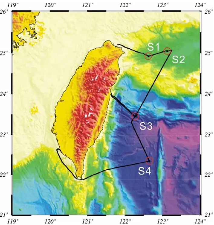
Up-to-date the Ryukyu subduction zone has been subject of tomographic imaging efforts (Lin et al., 2005), the mantle wedge associated with the subduction zone has never been illuminated to the same details because no receivers are located directly above it. In order to catch up on in situ seismic signal from subducting slab or Moho, four IES Broad-Band OBS (BBOBS) will be deployed around the same area (Fig.1). According to the relocated hypocenters of large earthquakes at Taiwan (Chou, et al., 2005), the subducted slab is achieved 60~80 km in depth at the western Okinawa Trough, and about 100 km for the location of the BBOBS1 (Fig. 1).
An effective way to estimate a more detailed structure of the subducted slab is the use of reflected or converted waves at the top or bottom of the subducted slab. Generally, P- and S-, and their converted phases occurred at the subducted plate boundaries can be easier identified within OBS seismograms. Other seismic phases, for instant, ScSp, ScS, might be mingled with the high background noise of OBS machine.
In this study, we take advantage of the tomography method constructed by Zhao et al (1992; 1994) to estimate the seismic velocity variation in tomographic inversions. This method can deal with a general velocity model in which complex velocity discontinuities and the velocity changes in three dimensions. As it used to exhibit a large background noise within the OBS records,
P-wave and S- wave arrivals may be co-used in our calculation for a more robust resolution.
Other distinct arrival phases will be adopted for identifying the upper and lower boundary of subducting slab.
In the first year we have deployed 4 BBOBS array at the concerned area. It’s planned to receive data in August and September. In view of lots important earthquakes taken place in the last one year, we anticipate to be able to gain many interesting records then. All the experience
II. Methodologies – Tomography Inversion Model
In this study, we take advantage of the original method of Zhao et al., (1992; 1994) for tomographic inversion. And because of the limit of frequency band with OBS machine, we only pick up the local events which can be well recorded their waveform at OBS stations. The medium under study is divided into layers by the discontinuities. Three- dimensional grid nodes are arranged in every layer. Velocities at grid nodes are taken to be unknown parameters. The velocity at any point in the model is calculated by linearly interpretation the velocities at the eight grid nodes surrounding that point. Local earthquakes are relocated in the inversion process. The nonlinear tomographic problem is solved by iteratively conducting linear inversions until a convergent solution is found.
The observed travel time T from the jth event at the ith station can be written as
3 T = T + ( )ij Δφj + ( )ij Δλj + ( )ij Δhj + ΔToj + Σ ΔVk + Eij (1) δT δφ obs δT δVk δT δλ ij δT δλ cal ij obs ij
where T is calculated travel time; φj, λj, hj, Toj are latitude, longitude, focal depth, and
origin time of the jth event; Vk is velocity at the kth grid node; Δ denotes perturbation of a
parameter; and Eij are higher order terms of perturbations and error in the observation. We write
the travel time residual as
tij = Tij – Tij (2) cal
ij
cal obs
Ray paths of seismic waves for the local and regional earthquake are entirely located in the modeling space. We used the efficient 3-D ray tracing technique of Zhao et al. (1992) to trace rays between hypocenters and receivers and calculate theoretical travel times T and travel time residuals tij.
The iteration inversion techniques have been used to solve directly the observed travel time residual. This method has been used by several researchers and is confirmed to be a very efficient algorithm to solve tomography problem.
cal ij
III. Result
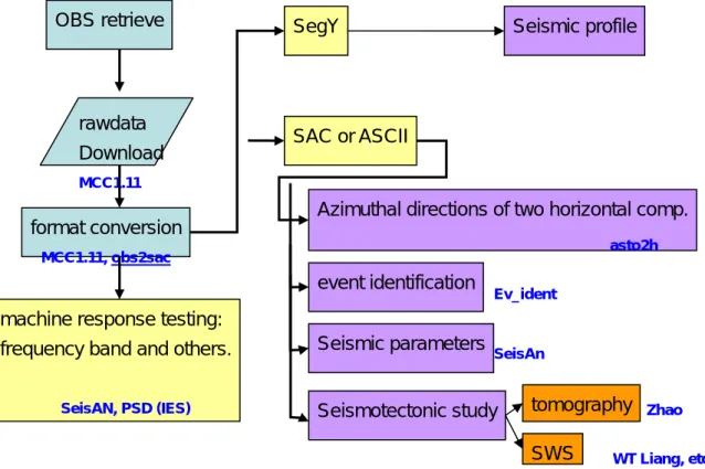
Because all of the four BBOBS are still set in water, we have so far no seismic data for real analysis. However, data process flow has been established (Fig. 2). We can product significant analyses as soon as successfully charging OBS data.
IV. References
Chou, H. C., B.Y. Kuo, S.H. Hung, L.Y. Chiao, Y.M. Wu, and D. Zhao (2005). The Taiwan-Ryukyu subduction-collision complex: folding of a viscoelastic slab and the double seismic zone, J. Geophys. Res., sous presse.
Hasegawa, A., S. Horiuchi, and N. Umino, (1994). Seismic structure of the northeastern Japan convergent margin: a synthesis, Jour. Geophy. Res., vol. 99, 22295-22311.
Lin, J.Y., J.-C. Sibuet, C.S. Lee, S.K. Hsu, F. Klingelhoefer, Y. Auffret, P. Pelleau, J. Crozon, and C.H. Lin (2005). Microseismicity and tomography in the Southern Okinawa Trough, in Proceeding of the GEEA conference, November 28~December 1, 2005, at Taitung, Taiwan. Zhao D., A. Hasegawa, and S. Horiuchi (1992). Tomographic imaging of P and S wave velocity
structure beneath northeastern Japan, J. Geophys. Res., 97, 19909-19928, 1992.
Zhao D., A. Hasegawa, and H. Kanamori (1994). Deep structure of Japan subduction zone as derived from local regional, and teleseismic events, J. Geophys. Res., 99, 22313-22329.
Figure 1. Spatial deployment of 4 BBOBS in eats Taiwan, September 2006.
OBS retrieve SegY Seismic profile
Figure 2. flowchart of data process. The corresponding programs are indicated their names in blue. rawdata Download MCC1.11 format conversion MCC1.11, obs2sac SAC or ASCII
machine response testing: frequency band and others.
Azimuthal directions of two horizontal comp.
event identification Seismic parameters asto2h Ev_ident SeisAn tomography Seismotectonic study
SeisAN, PSD (IES) Zhao
Minutes of Attending 2007 SSA Assembly
Convention Title: Seismological Society of America, 2007 General Assembly Date: 2007. 04. 11~ 2007. 04. 15
Venue: Waikoloa, Big Island, Hawaii, US Attendant: Emmy Tsui-Yu CHANG Participant Topic:
Seismotectonic Characterization of Northernmost Manila Subduction: OBS observation Offshore SW Taiwan
General ideas after 2007 SSA:
The 2007 SSA Assembly held at Hawaii, Big Island. Venue of conference was in the Waikoloa Villa resort, a luxury and comfortable place for meeting and leisure. I’m so pleased to be able to attend this conference, to meet many excellent seismologists there. Point of this meeting is to advance volcanic seismology. It’s indeed, mass of mafic lava covers a great surface of Big Island, which is no doubt related with a vigorous volcanic activity. Use of OBS
(Ocean-Bottom-Seismometer) is more and more appreciated in this domain. Some of newly publications about volcanic seismograms set their experimental fields around Hawaii hotspot chain (for instance, the PLUME project, etc). My study is based on OBS experiment at southwest Taiwan. Before the deployment pf OBS, it’s difficult to have a local observation of mediate-to-small earthquakes at offshore Taiwan. However, the active seismicity around Taiwan is mainly generated in the suduction mechanism at trenches. My study denotes a considerable seismic activity in the southwestern subduction zone. The seismicity forms a easternward dipping plane. This is probably being an important structure for the south convergent system of Taiwan.
During the conference time, I’ve fully discussed my approaches with other seismologists, who carry out their studies on another seismogenies. We exchanged ideas in varied experiences in seismology. Ultimately, it showed a global similarity for seismological study, even taking experiments in different sites, we can achieve a great accordance for the generation of subduction earthquake.
Important Programs
New Developments in Semi-automatic and Fully-automatic tools in Seismic Data Analysis Data Mining and Simulation for Earthquake Analysis, Forecasting and Prediction
Volcano Seismoacoustics: Synchronizing Sound and Vibration Towards an Integrated Understanding of Earthquake Interactions Very Near-field Earthquake Source Observations
[ABSTRACT]
The Manila trench is well-known as the convergent boundary where the South China Sea plate subducting easternward beneath the Philippine archipelago. As the oblique subduction/collision of plates taken place around the Taiwan area, the topographic feature of the Manila trench lose its topographic identification when approaching northernward to Taiwan. Systematic study for the seismic source parameters along the Manila trench is an important clue to resolve the issue of the complicated plate interaction in the vicinity of northern Manila trench. However, seismographic instrumentation is largely limited by inland territory, and we therefore used to have a scarcity for the earthquake exploration in the marine area. Recently, thanks to the successful development of Ocean Bottom Seismometer (abbr. OBS) and its facility in detecting earthquake, we can have a better resolution for the marine seismicity. This study is constructed by two OBS arrays deployed at the northern extreme of the Manila trench respectively in the years of 2005 and 2006. Local seismic signals have been well logged by the used short-period OBS machines. Hundreds earthquakes including micro-events are successfully compiled from these seismograms, and focal mechanisms can be determined by means of near-field waveform simulations for some of the large earthquakes. The preliminary study with these seismic data shows a clear subducting mechanism toward northeast beneath the Taiwan island, and the near-field focal mechanical solutions reveal an apparent convergent force acting in this area in NW-SE direction. A clustering algorithm is applied to the relocated earthquakes in order to obtain tighter earthquake clouds and thus better-defined seismogenic zone. The seismic velocity structure of the relevant region is refined with the OBS records in this study.