On: 25 April 2014, At: 08:44 Publisher: Taylor & Francis
Informa Ltd Registered in England and Wales Registered Number: 1072954 Registered office: Mortimer House, 37-41 Mortimer Street, London W1T 3JH, UK
Journal of the Chinese Institute of Engineers
Publication details, including instructions for authors and subscription information: http://www.tandfonline.com/loi/tcie20
Shallow
‐water gravity anomalies from satellite
altimetry: Case studies in the east china sea and
Taiwan strait
Cheinway Hwang a & Hsin‐Ying Hsu b
a
Department of Civil Engineering , National Chiao Tung University , 1001 Ta Hsueh Road, Hsinchu 300, Taiwan, R.O.C. Phone: 886–3–5724739, 0953092239 Fax: 886–3–5724739, 0953092239 E-mail:
b
Department of Civil Engineering , National Chiao Tung University , 1001 Ta Hsueh Road, Hsinchu 300, Taiwan, R.O.C.
Published online: 04 Mar 2011.
To cite this article: Cheinway Hwang & Hsin‐Ying Hsu (2008) Shallow‐water gravity anomalies from satellite altimetry: Case studies in the east china sea and Taiwan strait, Journal of the Chinese Institute of Engineers, 31:5, 841-851, DOI: 10.1080/02533839.2008.9671437
To link to this article: http://dx.doi.org/10.1080/02533839.2008.9671437
PLEASE SCROLL DOWN FOR ARTICLE
Taylor & Francis makes every effort to ensure the accuracy of all the information (the “Content”) contained in the publications on our platform. However, Taylor & Francis, our agents, and our licensors make no
representations or warranties whatsoever as to the accuracy, completeness, or suitability for any purpose of the Content. Any opinions and views expressed in this publication are the opinions and views of the authors, and are not the views of or endorsed by Taylor & Francis. The accuracy of the Content should not be relied upon and should be independently verified with primary sources of information. Taylor and Francis shall not be liable for any losses, actions, claims, proceedings, demands, costs, expenses, damages, and other liabilities whatsoever or howsoever caused arising directly or indirectly in connection with, in relation to or arising out of the use of the Content.
This article may be used for research, teaching, and private study purposes. Any substantial or systematic reproduction, redistribution, reselling, loan, sub-licensing, systematic supply, or distribution in any
form to anyone is expressly forbidden. Terms & Conditions of access and use can be found at http:// www.tandfonline.com/page/terms-and-conditions
SHALLOW-WATER GRAVITY ANOMALIES FROM SATELLITE
ALTIMETRY: CASE STUDIES IN THE EAST CHINA SEA AND
TAIWAN STRAIT
Cheinway Hwang* and Hsin-Ying Hsu
ABSTRACT
The differences between two global satellite altimeter-derived gravity anomaly grids over the East China Sea and the Taiwan Strait are investigated and the causes of the differences are discussed. Difference of gravity anomaly is correlated with tide model error, standard deviation of sea surface heights (SSHs) and ocean depth. We present two new SSH-derived observations of altimetry (differenced height and height slope) for gravity derivation. An iterative method for removing altimeter data outli-ers is used, and differenced height is found to be most sensitive to this method. For altimeter-gravity conversion, we used three altimeter-derived observations, i.e., de-flection of the vertical, differenced height and height slope, in two conversion methods, i.e., the least-squares collocation (LSC) and the inverse Vening Meinesz method. Use of differenced heights in LSC produces the best result when comparing altimeter-derived and shipborne gravity anomalies. Use of land gravity data in the vicinity of coasts enhances the accuracy of altimeter-derived gravity anomalies.
Key Words: satellite altimetry, gravity anomaly, East China Sea, Taiwan Strait.
*Corresponding author. (Tel: 886-3-5724739, 0953092239; Fax: 886-3-5716257; Email: [email protected])
C. W. Hwang and H. Y. Hsu are with the Department of Civil Engineering, National Chiao Tung University, 1001 Ta Hsueh Road, Hsinchu 300, Taiwan, R.O.C.
I. INTRODUCTION
Satellite altimetry over shallow waters has been very useful in geodetic, geophysical and oceanographic applications. Recent compilations of such altimetric applications are, among others, Fu and Cazenave (2001) and Hwang et al. (2004). One example of geodetic application is coastal gravity field modeling: use of combined coastal altimetry data with terrestrial gravity anomalies has resulted in gravity field models that outperform models using only terrestrial gravity data (Li and Sideris, 1997; Andersen and Knudsen, 2000). Furthermore, the potential of satellite altimetry in determining coastal sea surface topography has also been exploited in Hipkin (2000). Sea surface topog-raphy is the essential parameter for a world vertical datum (Rapp and Balasubramania, 1992). For oceano-graphic applications, shallow-water altimetry has been
used to derive M-2 internal tides (Niwa and Hibiya, 2004) and variations of surface ocean circulations (Yanagi et al., 1997). Examples of geophysical ap-plications of altimetry are abundant in the literature; we refer interested readers to Cazenave and Royer (2001) for a comprehensive review.
Altimeter-gravity conversion is one of the most important aspects in the geodetic and geophysical applications of satellite altimetry. Currently, the achieved accuracies of altimeter-derived gravity anomalies vary from one oceanic region to another, depending on gravity roughness, altimeter data qual-ity and densqual-ity (Sandwell and Smith, 1997; Hwang
et al., 2002; and Andersen et al., 2005). Accuracy
analyses associated with global gravity anomaly grids have been mostly made over the open oceans. However, altimeter data quality over shallow waters can be seriously degraded due to (1) bad tidal correction, (2) bad wet tropospheric correction be-cause of corruption in radiometer measurements (for altimeter mission with a radiometer; Geosat does not carry a radiometer so radiometer errors are not a sig-nificant error source), (3) large sea surface variability, and (4) contaminated altimeter waveforms (Hwang
and Hsu, 2004; Deng, 2003). Inferior or erroneous altimeter data will lead to gravity anomalies contain-ing artifacts and in turn false interpretations of the underlying geophysical phenomena.
The East China Sea and the Taiwan Strait are two typical shallow-water areas, defined as waters with a depth < 500 m in this paper. Here the gravity fields are relatively smooth, but large gravity variations occur over regions with thick sediments, structural highs and at the margin of the continental shelf. Fig. 1 shows the bathymetry in the East China Sea and the Taiwan Strait. Over the East China Sea, publicly accessible databases of shipborne gravity data can be found at, e.g., the National Geophysical Data Center (NGDC) (http://www.ngdc.noaa.gov) and International Gravi-metric Bureau (http://bgi.cnes.fr:8110/). In most ar-eas of the ocean, shipborne gravity data are sparsely distributed. In the Taiwan Strait, the shipborne gravity data were mostly collected by research vessels studying marine geophysics around Taiwan. Global altimeter-derived gravity anomaly grids have been important sources of gravity anomalies in these areas. Due to the shallow-water nature of these areas, the proce-dures used in the derivations of global grids may not be optimal. Therefore, it is expected the accuracy of altimeter-derived gravity anomalies can be improved. Also, it is possible to further improve the gravity ac-curacy by using a different altimeter data type than
commonly used ones such as sea surface height (SSH) and deflection of the vertical (DOV). With these prob-lems as the background, the objective of this paper is to (1) investigate selected sources of error in altim-eter-derived gravity anomaly and data processing is-sues in altimetry, and (2) experiment with different altimeter-derived observations in gravity computation to see how the results are compared with shipborne gravity anomalies. Case studies, using data from over the East China Sea and the Taiwan Strait, were also examined.
II. DIFFERENCE OF TWO GLOBAL GRAVITY ANOMALY GRIDS OVER
SHALLOW WATERS
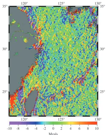
The motivation of this paper is the large differ-ences over shallow waters between two commonly used global gravity anomaly grids given below. One grid is the 2002 version of the global gravity anomaly grid of Sandwell and Smith available at http://topex. ucsd.edu. The method to compute this grid is described in Sandwell and Smith (1997). Another grid is from Andersen et al. (2005). The two grids are derived mainly from Geosat/GM and ERS-1/GM altimeter data using different methods, and are hereafter designated as SS02 and KMS02. Fig. 2 shows the differences 35° 30° 25° 35° 30° 25° 120° 125° 130° 120° 125° 130°
Fig. 1 Bathymetry (dashed lines) in the East China Sea and
Tai-wan Strait. Lines represent shipborne gravity data for com-parison with altimeter-derived gravity anomalies
35° 30° 25° 35° 30° 25° 120° 125° 130° 120° -8 -6 -10 -2 0 Mgals -4 2 4 6 8 10 125° 130°
Fig. 2 Differences between the SS02 and KMS02 global gravity
anomaly grids
between SS02 and KMS02 gravity anomalies. There are large differences near coastlines, but smaller dif-ferences throughout the study area. The difdif-ferences exhibit a bumpy texture with a diamond shaped fabric, most likely due to altimeter track lines. It appears the two grids have different spectral contents at short wavelengths. In particular, large differences occur over almost the entire Taiwan Strait, and some areas distant from the coasts also contain large differences, e.g., a spot off the east coast of China centering at about latitude = 28°N and longitude = 122°E.
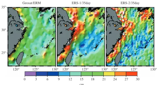
In order to see the possible causes of the differences, we investigate the qualities of SSHs and two selected tide models here. An SSH, in this paper, is defined as the vertical distance of the sea surface from a reference ellipsoid. Fig. 3 shows the standard deviations of SSH. from the Geosat/ERM, ERS-1/ 35 day and ERS-2/35 day repeat missions. The SSHs have been corrected for standard geophysical correc-tions such as ocean tide, solid earth tide, sea state bias, ionospheric and tropospheric effects and inverse barometer effect (the same effects as those given in Hwang et al., 2002). Here a standard deviation of SSH is the result of SSH measurement error and SSH variability. The standard deviations of Geosat/ERM SSHs are relatively small because a large number of repeat cycles (68 cycles) were used, compared to only 26 cycles used in averaging ERS-1 and ERS-2 repeat SSHs. The pattern of ERS-1 standard deviations re-sembles that of ERS-2 standard deviations. In general, standard deviation of SSH increases with decreasing depth. As seen in Figs. 2 and 3, gravity anomaly dif-ference is highly correlated with standard deviation of SSH. In general, gravity anomaly difference (absolute value) increases with standard deviation of SSH. 35° 30° 25° 120° 125° 0 3 6 9 12 15 cm 18 21 24 27 30 Geosat/ERM 130° 120° 125° ERS-1/35day 130° 120° 125° ERS-2/35day 130°
Fig. 3 Standard deviations of sea surface heights from the Geosat/ERM, ERS-1/35 day and ERS-2/35 day repeat missions
40° 38° 36° 34° 32° 30° 28° 26° 24° 22° 40° 38° 36° 34° 32° 30° 28° 26° 24° 22° 118° 0 2 4 6
Gradient error (µrad)
8 10
120° 122° 124° 126° 128°
118° 120° 122° 124° 126° 128°
Fig. 4 Geoid gradient errors along ERS-1 tracks, based on the
differences between NAO99b and CSR4.0 tide models
Figure 4 shows geoid gradient errors along ERS-1/GM tracks based on the differences between the NAO tide model (Matsumoto et al., 2000) and the CSR4.0 tide model (Eanes, 1999). A geoid gra-dient error between consecutive along-track points is computed as |∆h2 – ∆h1|/s, where ∆h2 and ∆h1 are the
differences between NAO and CSR4.0 tidal heights at the two points, and s is the distance (see also the height slope in Section III.1). Here we assume that the tide model error in the East China Sea and the Taiwan Strait is about the same magnitude as the dif-ference between NAO and CSR4.0. According to Hwang et al. (2002), the NAO tide model outperforms CSR4.0 in the East China Sea and the Taiwan Strait. A one µrad gradient error will translate into a one-mgal error in altimeter-derived gravity. Again, large gradient errors occur in the same places where large standard deviations of SSHs (Fig. 3) and large grav-ity anomaly differences (Fig. 2) occur, showing these three quantities are geographically correlated. The NAO and CSR4.0 tide models are derived from the TOPEX/Poseidon (T/P) altimeter data. Over areas with bad T/P SSHs, which are largely caused by bad range measurements and bad geophysical corrections, these two tide models will produce inaccurate tidal heights. Also, neglecting shallow-water tidal con-stituencies in the tide models introduces additional errors. Those areas with large differences in Fig. 4 are just where NAO and CSR4.0 produce inaccurate tidal heights. Use of these inaccurate tidal heights to correct for the tidal effects in altimeter data will in-evitably lead to degraded SSHs, and creates large standard deviations seen in Fig. 3.
According to Jan et al. (2004) and Lefevre et
al. (2000), ocean tides in the East China Sea and the
Taiwan Strait are complex with high-frequency spa-tial variations in tidal amplitude and phase. The strong, fast-changing tidal currents over the Taiwan Strait also increase the roughness of the sea surface and in turn increase the noise level of altimeter ranging (Sandwell and Smith, 2001, pp. 444). This explains why the tide model error over the Taiwan Strait is large through-out almost the entire area (Fig. 4). In addition, the monsoonal winds in winter and summer induce large waves over the East China Sea and the Taiwan Strait (Jacobs et al., 2000; Wang, 2004), resulting in a large sea surface variability lasting more than half of a year. Therefore, one would expect that the noise level of altimeter measurements in these two areas is higher than that over a calm sea. In conclusion, inferior al-timeter range measurements and inferior geophysi-cal corrections combine to produce inferior SSHs, which in turn result in degraded gravity anomalies. More discussions on the limitations of gravity recov-ery from altimetry can be found in Sandwell and Smith (2001).
III. METHOD AND DATA FOR GRAVITY DERIVATION OVER SHALLOW WATERS
1. Deflection of the Vertical, Differenced Height and Height Slope
The basic observation of satellite altimetry for gravity derivation is SSH. SSH-derived observations can also be used for this purpose. For example, DOV has been used by Sandwell and Smith (1997) and Hwang et al. (2002), with the advantage of reduction of long wavelength errors in altimeter data without crossover adjustment of SSHs (Sandwell and Smith, 1997; Hwang, 1997). Typical long wavelength er-rors are orbit error and ocean tide model error. Along-track DOV is defined as
ε= –∂∂h
s, (1)
where h is geoidal height obtained by subtracting the sea surface topography (SST, defined as the vertical distance of the sea surface from the geoid) from SSH, and s is the along-track distance. Since h is discretely sampled, DOV in Eq. (1) can only be approximately computed. On the other hand, differenced height is free from approximation. A differenced height is de-fined as
di = hi + 1 – hi, (2) where i is index of an SSH observable. Using differenced height has the same advantage as using DOV in terms of mitigating long wavelength errors. Another SSH-derived observation is height slope, defined as
χi=
hi + 1– hi
si , (3)
where si is the distance between the points associ-ated with hi and hi + 1. The spectral characteristics of height slope are the same as those of DOV and grav-ity anomaly, because they are all first spatial deriva-tives of the Earth’s disturbing potential. Again, the advantage of using height slope is similar to that of using differenced height in mitigating altimeter data errors.
To derive gravity anomaly from DOV, differenced height or height slope, one can use least-squares col-location (LSC) (Moritz, 1980), which requires mod-eling of the needed covariance functions. Modmod-eling of covariance functions for the DOV-gravity conver-sion has been carried out by Hwang and Parsons (1995). Here we shall model the covariance functions for height difference-gravity and height slope-gravity conversions. The covariance function between two differenced heights is
cov(di, dj) = cov(hi + 1 – hi, hj + 1 – hj) = cov(hi + 1, hj + 1) – cov(hi + 1, hj) – cov(hi, hj + 1) + cov(hi, hj). (4) The covariance function between two height slopes is
cov(χi,χj) = 1s
isjcov(di, dj) . (5) The covariance function between gravity anomaly and differenced height is
cov(∆g, di) = cov(∆g, hi + 1 – hi)
= cov(∆g, hi + 1) – cov(∆g, hi). (6) Finally, the covariance function between gravity anomaly and height slope is
cov(∆g,χi) = 1s
icov(∆g, di) .
(7) It is clear that in Eqs. (4) to (7), two basic covariance functions are needed: the covariance function between two heights and the covariance function between gravity anomaly and height. Methods to model these two covariance functions can be found in Tscherning and Rapp (1974) and Moritz (1980). In this paper, we use the Model 4 gravity anomaly variance of Tscherning and Rapp (1974) to compute the needed covariance functions, see also Hwang and Parsons (1995). Furthermore, we used the remove-restore procedure with the EGM96 model (Lemoine et al., 1998) as the reference gravity field.
The general expression of LSC for altimeter-gravity conversion is
∆g = Csl(Ct + Cn)–1l , (8)
where vector l contains any data related to the Earth’s disturbing potential, Ct and Cn are the signal and noise
parts of the covariance matrices of l, and Csl is the
covariance matrix of gravity anomaly and the signal of l. Altimeter data can also be used to compute geoidal undulation: one simply replaces Csl with the
covariance matrix of geoid- signal of l in Eq. (8). As-suming that the errors in the undifferenced height data are uncorrelated, the correlation between two succes-sive DOVs, differenced heights or height slopes along the same satellite pass is -0.5, which must be included in Cn. The FFT-based method of gravity derivation
using DOV can be found in, e.g., Sandwell and Smith (1997), and Haxby et al. (1983).
2. Coastal Land and Sea Data for Accuracy En-hancement
Altimeter-gravity conversion at the land-sea
boundary is an extrapolation process since land al-timeter data cannot be used for gravity derivation. In the immediate waters off the coast, there can be no reliable altimeter data due to waveform contamina-tion (Deng et al., 2003). Also, because of depth limi-tation a large research ship cannot closely approach the coasts, so there are always void zones of shipborne gravity. This deficiency can be reduced by using data near the coasts, including gravity anomalies from rela-tive and airborne gravity surveys (Torge, 1989), DOVs from astro-geodetic surveys and geoidal heights from Global Positioning System (GPS) and leveling surveys (Wolf and Ghilani, 2002). A GPS-leveling-derived geoidal height, N, is defined as
N = h – H, (9) where h and H are ellipsoidal height and orthometric height, respectively. Due to the need for these fig-ures in engineering and mapping applications, geoi-dal heights from GPS and leveling in coastal areas may be abundant. In the case of combining altimeter readings and other data for gravity derivation, it would be difficult to use an FFT-based method even if it is possible (e.g., the input-output system method (Li and Sideris, 1997)). The LSC method outlined in Sec-tion III.1 is an efficient method for data combinaSec-tion, only requiring related models of covariance functions. To merge altimeter data and land/sea data for gravity anomaly determination, one needs to include such data in the l vector in Eq. (8), and the needed covariance matrices are constructed using the rule of LSC (Moritz, 1980). A good weighting scheme for different types of data is essential for obtaining a good result. The usefulness of land gravity data in enhancing the ac-curacy of altimeter-derived gravity anomaly will be demonstrated in Section V.2.
IV. OUTLIER DETECTION
Outliers in altimeter data will create a damag-ing effect on the resultdamag-ing gravity fields and must be removed before filtering. Methods for removing out-liers in one-dimensional time series are abundant in the literature, e.g., Koch (1987) and Pearson (2002). In this paper, we will use an iterative method to de-tect outliers in along-track altimeter data. This method follows closely the principle of normal point reduction for satellite laser ranging (Seeber, 2003). Consider a time series of along-track altimeter read-ings observable with the along-track distance as the independent variable. First, a filtered time series is obtained by convolving the original time series with the Gaussian function
f(x) = e– x
2
2σ2, (10)
where x is the distance between two data points and
σ is 1/6 of the given filter width of convolution. A
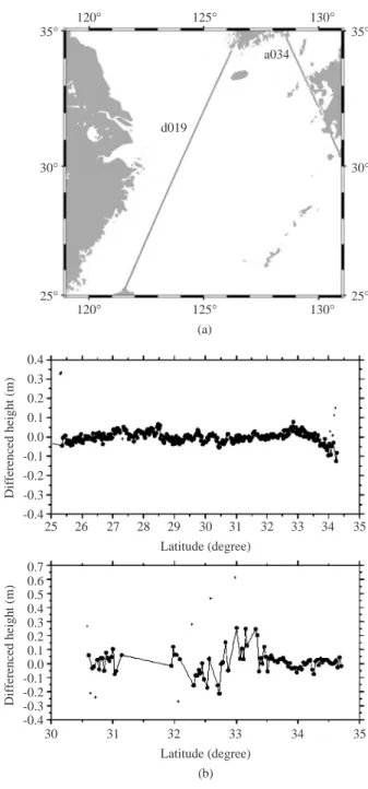
filter width is the size of a window within which all data points are convolved with the Gaussian function. The definition of the Gaussian function in Eq. (10) is the same as that defined in module “filter1d” of GMT (Wessel and Smith, 1995). For all data points the differences between the original and the filtered val-ues are computed, and the standard deviation of such differences is determined. The largest difference that also exceeds three times the standard deviation is considered an outlier and the corresponding data value is removed from the time series. The initially cleaned time series is filtered again and the new differences are examined against the new standard deviation to remove remaining outliers. This process is repeated and terminated when no outlier is found. It turns out differenced height is more sensitive to outliers than SSH, especially when along-track SSHs experience an abrupt change. A spike of SSH will create two distinct height differences. We experimented with several filter widths. It was concluded that different filter widths should be used for different sets of al-timeter data for best results. Based on testing results, we adopt 28 km and 18 km as the optimal filter widths for the repeat and non-repeat missions, respectively. Figure 5 shows the result of outlier detection along Tracks d019 and a034 of Geosat/ERM. Track d019 passes through the East China Sea and is far away from the coasts. In this case, outliers occur only at the two ends of this arc, near South Korea and Taiwan. As expected, the differenced heights in the open sea are relatively smooth. Track a034 is a short arc passing through the Korean Strait between S. Korea and Kyushu of Japan. This track contains no outliers over the Ko-rean Strait, but many along the coasts of Kyushu. Along Track a034, most of the differenced heights near the coasts are highly oscillatory, making it difficult to de-rive useful gravity anomalies from such values. Furthermore, Fig. 6 shows the result of outlier detec-tion along Tracks d0222 and a3083 of Geosat/GM. Both tracks pass through Peng-Hu Island in the Taiwan Strait, where most of the outliers occur and the differenced heights contain large variation. These examples from the Geosat altimeter show that differenced height is very sensitive to sudden changes in height, and is par-ticularly useful for outlier detection utilizing the above iterative method. Since Geosat does not carry a radiometer, the outliers in Figs. 5 and 6 are not due to land interference in the radiometer’s footprint.
V. CASE STUDIES
1. The East China Sea
The first case study to assess the accuracies of
gravity anomaly from the three altimeter-derived ob-servations was carried out in the East China Sea. The altimeter data we used are from the non-repeat mis-sions ERS-1/GM and Geosat/GM (the sampling rate is 2 HZ), and the repeat missions Geosat/ERM, ERS-1/35-day, ERS-2/35-day and TOPEX/Poseidon 10-day repeats (the sampling rate is 1 HZ; see Section II for the numbers of repeat cycles). Since no reliable estimate of SST is available here, it was set to zero. Neglecting SST here will introduce error at the sub-mgal level (Hwang, 1997). For LSC computations, standard errors of the altimeter data are needed. For
35° 30° 25° 0.4 0.3 0.2 0.1 0.0 -0.1 -0.2 -0.3 -0.4 35° 30° 25° 120° 25 26 27 28 29 30 Latitude (degree) Differenced height (m) 31 32 33 34 35 0.7 0.6 0.5 0.4 0.3 0.2 0.1 0.0 -0.1 -0.2 -0.3 -0.4 30 31 32 Latitude (degree) (b) Differenced height (m) 33 34 35 125° (a) 130° 120° d019 a034 125° 130°
Fig. 5 (a) Ground tracks of Geosat/ERM d019 and a034,
(b) differenced heights, crosses represent outliers
repeat missions, the standard errors of the altimeter data are derived from repeat observations, while for non-repeat missions, the standard errors are based on
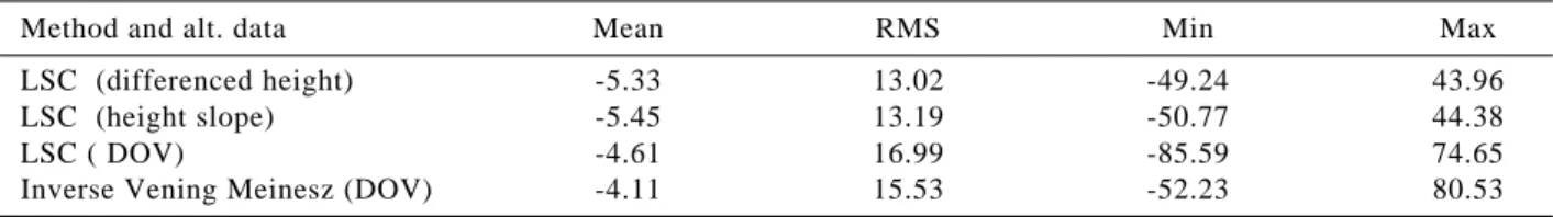
Table 1 Statistics of differences (in mgals) between altimeter-derived and shipborne gravity anomalies in the East China Sea
Method and alt. data Mean RMS Min Max
LSC (differenced height) -5.33 13.02 -49.24 43.96
LSC (height slope) -5.45 13.19 -50.77 44.38
LSC ( DOV) -4.61 16.99 -85.59 74.65
Inverse Vening Meinesz (DOV) -4.11 15.53 -52.23 80.53
Fig. 6 (a) Ground tracks of Geosat/GM d0222 and a3083,
(b) differenced heights, crosses represent outliers
empirical values (Hwang et al., 2002). All altimeter data were screened against outliers using differenced heights. Due to data editing in extracting SSHs from the geophysical data records (GDRs), most of the bad altimeter data in the immediate vicinity of coasts have already been removed before outlier detection. In general, there is a higher concentration of outliers near the coasts and islands than other areas. In particular, clusters of outliers were found at the southern Ko-rean coast, the estuary of the Yangtze River and Peng-Hu Island in the Taiwan Strait.
We experimented with four cases of altimeter-gravity conversion. In these four cases, we used two methods of conversion: LSC and the inverse Vening Meinesz method (Hwang, 1998), and three altimeter-derived observations: DOV, differenced height and height slope. To identify the best case, we compared the altimeter-derived gravity anomalies with shipborne gravity anomalies. Fig. 1 shows the tracks of two selected ship cruises in the East China Sea (Tracks dmm07 and c1217) and two cruises in the Taiwan Strait (Tracks 1 and 2). The shipborne gravity data in the East China Sea are from the Lamont-Doherty Earth Observatory database and the accuracies of gravity anomalies on Tracks dmm07 and c1217 were discussed in Wessel and Watts (1988). Before comparison, for each track we removed a bias and a trend in the shipborne gravity relative to the altimeter-derived gravity anomalies (Hwang and Parsons, 1995; Wessel and Watts, 1988). Table 1 shows the statistics of the differences between the altimeter-derived and shipborne gravity anomalies. The best result is from the case of using LSC with differenced height, fol-lowed by the case of using LSC with height slope. The case of using LSC with DOV yields the least ac-curate gravity anomalies. Fig. 7 shows the shipborne and altimeter-derived gravity anomalies along c1217 and dmm07. In general, the altimeter-derived ity anomalies are smoother than the shipborne grav-ity anomalies. This is due to the filtering of the altimeter observations before the gravity derivations. At large spatial scales, the shipborne and altimeter-derived gravity anomalies agree very well, but at small spatial scales the differences become random and are not correlated with the standard deviation of SSH, tidal model error or depth (see Figs. 1, 3 and 4).
26° 24° 22° 1.0 0.8 0.6 0.4 0.2 0.0 -0.2 -0.4 -0.6 -0.8 -1.0 26° 24° 22° 118° 21 22 23 Latitude (degree) Differenced height (m) 24 25 26 1.0 0.8 0.6 0.4 0.2 0.0 -0.2 -0.4 -0.6 -0.8 -1.0 22 23 24 Latitude (degree) (b) Differenced height (m) 25 26 120° (a) 122° 118° 120° 122° a3083 d0222
2. The Taiwan Strait
Next we carried out experiments in the Taiwan Strait using the same four cases as in the East China Sea. We used shipborne gravity data along Tracks 1 and 2 (Fig. 1) to evaluate the altimeter-derived grav-ity anomalies. These shipborne gravgrav-ity data were compiled by Hsu et al. (1998), who has crossover adjusted the shipborne gravity data and removed bad values. Table 2 shows the results of the comparisons between altimeter-derived and shipborne gravity anomalies in the four cases. The conclusion from
Table 2 is similar to what has been drawn from Table 1 and the only difference is that the inverse Vening Meinesz method with DOV produces the worst result. Again, use of differenced heights produces the best results provided that the same altimeter-gravity con-version method is used.
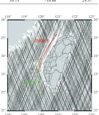
Since land gravity data are available along the coast of the Taiwan Strait, we also assessed the impact of land gravity data on the accuracy of altim-eter-derived gravity anomaly. Fig. 8 shows the dis-tribution of land gravity and Geosat/GM altimeter data around Taiwan. (Around Tracks 1 and 2, other altim-eter data are quite sparse and are not shown in Fig. 8). Note that there is no altimeter reading for the immediate coastal waters off the west coast of Taiwan. We experimented with the method of LSC using differenced heights, and with and without land grav-ity data (two cases). Table 3 shows the statistics of the differences between shipborne and altimeter-de-rived gravity anomalies. Fig. 9 shows the shipborne and altimeter-derived gravity anomalies along Tracks 1 and 2. The patterns of the difference along Tracks 1 and 2 are similar to those for Tracks c1217 and dmm07
Table 2 Statistics of differences (in mgals) between altimeter-derived and shipborne gravity anomalies in the Taiwan Strait
Method and alt. data Mean RMS Minimum Maximum
LSC (differenced height) 7.09 9.06 -8.92 23.56
LSC (height slope) 7.94 10.26 -9.39 28.96
LSC (DOV) 7.70 10.44 -10.97 29.38
Inverse Vening Meinesz (DOV) 7.59 10.73 -14.88 29.37
80 60 40 20 0 -20 -40 -60 -80 28 29 30 31
Gravity anomaly (mgal)
32 33 34 c1217 Shipborne gravity Altimeter-derived gravity 80 60 40 20 0 -20 -40 -60 -80 28 29 30 31 Latitude (degree) Latitude (degree)
Gravity anomaly (mgal)
32 33 34
dmm07
Shipborne gravity Altimeter-derived gravity
Fig. 7 Gravity anomalies along Cruises c1217 and dmm07 in the
East China Sea
26° 25° 24° 23° 22° 21° 118° 119° 120° 121° 122° 123° 118° 119° 120° 121° 122° 123° 26° 25° 24° 23° 22° 21°
Fig. 8 Distribution of land gravity and Geosat data around Taiwan
(Fig. 7). That is, the agreement between shipborne and altimeter-derived gravity anomalies at large spa-tial scales is better than that at small spaspa-tial scales. Furthermore, Tracks 1 and 2 are only tens of km off the west coast of Taiwan and the density of altimeter data is low along theses two tracks (Fig. 8). In general, difference of gravity anomaly increases with density of altimeter data. The density of land gravity data is relatively high over a zone from 22.5°N to 24.5°N, and here the agreement between altimeter-derived (with land gravity) and shipborne gravity anomalies is bet-ter than that in other parts of the ship tracks. In the areas south of 22.5° N and north of 24.5° N, only a few land gravity data are used, so there is virtually no difference between the altimeter-only gravity anoma-lies and the altimeter-land gravity anomaanoma-lies.
As discussed in Section II, the major source of large standard derivation of SSH and large error of altimeter-derived gravity anomaly is tide model error. From the case study in the Taiwan Strait, it is clear that a low density of altimeter data also contributes to errors in altimeter-derived gravity anomalies. Such
a low density of altimeter data arises mainly from data editing and is common in the vicinity of coasts. Even if the editing criteria near coasts are relaxed to retain more altimeter data, the surviving data may not be of good quality for gravity derivation. One way to im-prove altimeter data quality near coasts is to retrack waveforms of altimeter ranging. For example, Deng
et al. (2003) have obtained improved T/P SSHs by
waveform retracking over the Australian coasts. Currently, globally retracked ERS-1 and Geosat waveforms are available (Lillibridge et al., 2004; Smith et al., 2004), and have been shown to produce improved marine gravity fields.
VI. CONCLUSIONS AND SUGGESTIONS
This paper studies the sources of the differences among two global gravity anomaly grids over the East China Sea and the Taiwan Strait. We conclude that tide model error is the biggest contributor to the differences. It is found that tide model error, standard deviation of SSH and ocean depth are highly correlated. Also, the complicated sea states over these two areas increase the roughness of the sea surface and hence the noise level of altimeter ranging. As case studies, we experimented with three SSH-derived observations: DOV, differenced height and height slope. The com-parisons between altimeter-derived and shipborne gravity anomalies show that, with the same altimeter-gravity conversion method, differenced height delivers the best result. Also, including land gravity data in the vicin-ity of coasts enhances the accuracy of altimeter-derived gravity anomalies.
For future work, we recommend a procedure to improve the accuracy of altimeter-derived gravity anomalies: (1) retrack near-shore waveforms of al-timeter to produce waveform-corrected SSHs, (2) use the corrected SSHs to improve tide models, (3) use improved tide models to correct for the ocean tide effects in SSH. Finally, the improved tide-corrected and waveform-corrected altimeter data will lead to an improved gravity field over shallow waters.
ACKNOWLEDGEMENTS
This research is supported by the National
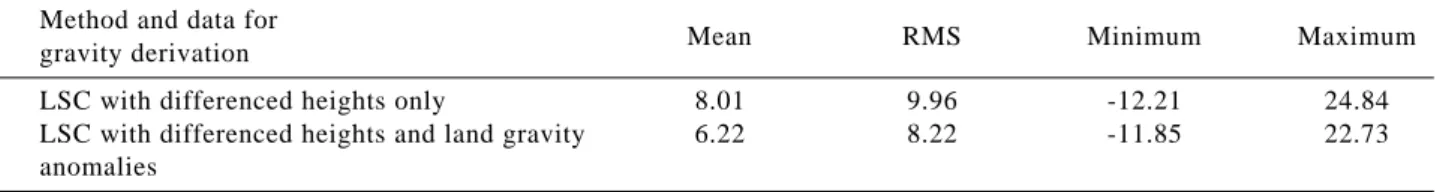
Table 3 Statistics of difference (in mgals) between altimeter-derived (with and without land data) and shipborne gravity anomalies in the Taiwan Strait
Method and data for
Mean RMS Minimum Maximum
gravity derivation
LSC with differenced heights only 8.01 9.96 -12.21 24.84
LSC with differenced heights and land gravity 6.22 8.22 -11.85 22.73
anomalies
Fig. 9 Gravity anomalies along Tracks 1 and 2 in the Taiwan Strait 40 20 0 -20 -40 23.0 23.5
Gravity anomaly (mgal)
24.5 25.0 25.5
track1 Shipborne gravityAltimeter-derived gravity (without land gravity)
Altimeter-derived gravity (with land gravity) Difference 24.0 Latitude (degree) 40 20 0 -20 -40 22.0 22.5
Gravity anomaly (mgal)
23.5 24.0
track2
Shipborne gravity
Altimeter-derived gravity (without land gravity) Altimeter-derived gravity (with land gravity) Difference
23.0 Latitude (degree)
Science Council of ROC, under Grant NSC96-2611-M-009-001.
NOMENCLATURE
Ct signal part of the covariance matrix of l
Cn noise part of the covariance matrix of l
Csl covariance matrix of gravity anomaly and the
signal of l
di differenced height (m)
ε along-track deflection of the vertical (arc-second)
∆g gravity anomaly (mgal)
hi ellipsoidal height from altimetry (m)
H orthometric height (m)
l vector containing data related to the Earth’s disturbing potential
si distance between two satellite points (m)
σ 1/6 of the given filter width of convolution (m)
x the distance between two data points for the Gaussian filter (m)
χi height slope (arc-second)
REFERENCES
Andersen, O. B., and Knudsen, P., 2000, “The Role of Satellite Altimetry in Gravity Field Modeling in Coastal Areas,” Physics and Chemistry of the
Earth (A), Vol 25, No 1, pp. 17-24.
Andersen, O. B., Knudsen, P., and Trimmer, R., 2005, “Improved High Resolution Altimetric Gravity Field Mapping” (KMS2002 Global Marine Gravity Field). International Association of Geodesy Symposia,
Proceedings of the International Association of Ge-odesy IAG General Assembly Sapporo, Japan,
Springer, Berlin, Heldelberg, Vol. 128, pp. 326-331. Cazenave, A., and Royer, J. Y., 2001, “Applications to marine geophysics,” Satellite Altimetry and
Earth Sciences: a Handbook of Techniques and Applications, Fu, L.L., Cazenave, A., Eds.,
Aca-demic Press, San Diego, USA, pp. 407-440. Deng, X., Featherstone, W. E., Hwang, C., and Berry,
P. A. M., 2003, “Estimation of Contamination of ERS-2 and POSEIDON Satellite Radar Altimetry Close to the Coasts of Australia,” Marine Geodesy, Vol. 25, No. 4, pp, 189-204.
Eanes, R., 1999, “Improved Ocean Tide Model from Satellite Altimetry,” Paper presented in Fall
Meeting 1999, American Geophysical Union, San
Francisco, USA.
Fu, L. L., and Cazenave, A. (Eds.), 2001, Satellite
Altimetry and Earth Sciences: A Handbook of Techniques and Applications, Academic Press,
San Diego, USA.
Haxby, W. F., Karner, C. D., Labrecque, J. L., and Weisel, J. K, 1983, “Digital Images of Combined
Oceanic and Continental Data Sets and Their Use in Tectonic Studies,” EOS Transaction of the
American Geophysical Union, Vol. 64, pp.
995-1004.
Hipkin, R., 2000. “Modeling the Geoid and Sea-sur-face Topography in Coastal Areas,” Physics and
Chemistry of the Earth (A), Vol. 25, No. 1, pp.
9-16.
Hsu, S., Liu, C., Shyu, C., Liu, S., Sibue, J., Lallemand, S., Wang, C., and Reed, D., 1998, “New Gravity and Magnetic Anomaly Maps in the Taiwan-Luzon Region and Their Preliminary Interpretation,” Terrestrial, Atmospheric and
Oceanic Sciences, Vol. 9, No. 3, pp. 509-532.
Hwang, C., and Parsons, B., 1995, “Gravity Anoma-lies Derived from Seasat, Geosat, ERS-1 and Topex/Poseidon Altimeter and Ship Gravity: A case Study over the Reykjanes Ridge,”
Geophysi-cal Journal International, Vol. 122, No. 2, pp.
551-568.
Hwang, C., 1997. “Analysis of Some Systematic Er-rors Affecting Altimeter-Derived Sea Surface Gradient with Application to Geoid Determina-tion over Taiwan,” Journal of Geodesy, Vol. 71, No. 2, pp. 113-130.
Hwang, C., 1998. “Inverse Vening Meinesz Formula and Deflection-Geoid Formula: Applications to the Predictions of Gravity and Geoid over the South China Sea,” Journal of Geodesy, Vol. 72, No. 5 pp. 304-312.
Hwang, C., Hsu, H. Y., and Jang, R., 2002, “Global Mean Sea Surface and Marine Gravity Anomaly from Multi-Satellite Altimetry: Applications of Deflection-Geoid and Inverse Vening Meinesz Formulae,” Journal of Geodesy, Vol. 76, No. 8, pp. 407-418.
Hwang, C., Hsu, H. Y., and Deng, X., 2004, “Marine Gravity Anomaly from Satellite Altimetry: A Comparison of Methods over Shallow Waters,”
Satellite Altimetry for Geodesy, Geophysics and Oceanography, International Association of
Ge-odesy Symposia, Hwang, C., Shum, C., Li, J.C., eds., Springer, Berlin, Germany, Vol. 126, pp. 59-66.
Hwang, C., Shum, C. K., and Li, J. C. (Eds.), 2004. “Satellite Altimetry for Geodesy,” Geophysics
and Oceanography, International Association of
Geodesy Symposia, Springer, Berlin, Germany, pp. 126.
Jan, S., Chern, C. S., Wang, J., and Chao, S. Y., 2004. “The Anomalous Amplification of M-2 Tide in the Taiwan Strait,” Geophysical Research Letters, Vol. 31, No. 7, pp. L073081-4.
Jacobs, G. A., Hur, H. B., and Riedlinger, S. K., 2000, “Yellow and East China Seas Response to Winds and Currents,” Journal of Geophysical Research,
Vol. 105, No. C9, pp. 21947-21968.
Koch, K. R., 1987, Parameter Estimation and
Hy-pothesis Testing in Linear Models, Springer, Berlin,
Germany.
Lefevre, F., Le Provost, C., and Lyard , F. H., 2000, “How Can We Improve a Global Ocean Tide Model at a Regional Scale? A Test on the Yellow Sea and the East China Sea,” Journal of
Geophysi-cal Research, Vol. 105, No. C4, pp. 8707-8725.
Lemoine, F. G., Kenyon, S. C., Factor, J. K., Trimmer, R. G., Pavlis, N. K., Chinn, D. S., Cox C. M., Klosko, S. M., Luthcke, S. B., Torrence, M. H., Wang, Y. M., Williamson, R. G., Pavlis, E. C., Rapp, R. H., and Olson, T. R., 1998, “The Devel-opment of Joint NASA GSFC and the National I m a g e r y a n d M a p p i n g A g e n c y ( N I M A ) Geopotential Model EGM96,” Report
NASA/TP-1998-206861, National Aeronautics and Space
Administration, Greenbelt, MD.
Li, J., and Sideris, M., 1997, “Marine Gravity and Geoid Determination by Optimal Combination of Satellite Altimetry and Shipborne Gravimetry Data,” Journal of Geodesy, Vol. 71, No. 4, pp. 209-216.
Lillibridge, J. L., Smith, W. H. F, Scharroo, R., and Sandwell, D. T., 2004, The Geosat Geodetic
Mis-sion Twentieth Anniversary Edition Data Product,
Paper Presented in Fall Meeting 2004, American Geophysical Union, San Francisco, USA. Matsumoto, K., Takanezawa, T., and Ooe, M., 2000,
“Ocean Tide Models Developed by Assimilating T O P E X / P o s e i d o n A l t i m e t e r D a t a i n t o Hydrodynamical Model: A Global Model and a Regional Model around Japan,” Journal of
Oceanography, Vol. 56, No. 5, pp. 567-581.
Moritz, H., 1980, Advanced Physical Geodesy, Herbert Wichmann, Karlsruhe, Germany. Niwa, Y., and Hibiya, T., 2004, “Three-Dimensional
Numerical Simulation of M-2 Internal Tides in the East China Sea,” Journal of Geophysical Research, Vol. 109, No. C4, C04027, DOI: 10.1029/ 2003JC001923.
Pearson, R. K., 2002, “Outliers in Process Modeling and Identification,” IEEE Transactions on Control
Systems Technology, Vol. 10, No. 1, pp. 55-63.
Rapp, R., and Balasubramania, N., 1992, “A Conceptual Formulation of a World Height System,” Report
No. 421, Department of Geodetic science and Surveying, Ohio State University, Columbus, Ohio.
Sandwell, D. T., Smith, W. H. F., 1997, “Marine Gravity Anomaly from Geosat and ERS-1 Satel-lite Altimetry,” Journal of Geophysical Research, Vol. 102, No. B5, pp. 10039-10054.
Sandwell, D. T., and Smith, W. H. F., 2001, “Bathy-metric Estimation,” Satellite Altimetry and Earth
S c i e n c e s : A H a n d b o o k o f T e c h n i q u e s a n d Applications, Fu, L.L. and Cazenave, A, (Eds),
Academic Press, NY, USA, pp. 21-40.
Seeber, G., 2003, Satellite Geodesy, Walter de Gruyter, Berlin, Germany.
Smith, W. H. F., and Sandwell, D. T., 2004, “Im-proved Global Marine Gravity Field from Repro-cessing of Geosat and ERS-1 Radar Altimeter Waveforms,” AGU 2004 Fall meeting, San Francisco, USA.
Torge, W., 1989, Gravimetry, Walter de Gruyter, Berlin, Germany.
Tscherning, C. C., and Rapp, R. H., 1974, “Closed Expressions For Gravity Anomalies, Geoid Un-dulations And Deflection Of The Vertical Implied By Anomaly Degree Variance Models,” Report
208, Department of Geodetic science and Surveying,
Ohio State University, Columbus, Ohio, USA. Wang, C. K., 2004, “Features of monsoon, typhoon
and sea waves in the Taiwan Strait,” Marine
Georesources and Geotechnology, Vol. 22, No.
3, pp. 133-150.
Wessel, P., and Watts, A. B., 1988, “On the Accu-racy of Marine Gravity Measurements,” Journal
of Geophysical Research, Vol. 93, No. B1, pp.
393-413.
Wessel, P., and Smith, W. H. F., 1995, “New Ver-sion Generic Mapping Tools Release,” EOS
Transaction American Geophysical Union, pp 76.
Wolf, P. R., and Ghilani, C. D., 2002, Elementary
Surveying, An Introduction to Geomatics, 10th
Ed., Pearson Education International, Upper Saddle River, NJ, USA.
Yanagi, T., Morimoto, A., and Ichikawa, K., 1997. “Seasonal Variation in Surface Circulation of the East China Sea and the Yellow Sea Derived from Satellite Altimetric Data,” Continental Shelf
Research, Vol. 17, No. 6, pp. 655-664.
Manuscript Received: July 18, 2007 Revision Received: Apr. 12, 2008 and Accepted: May 12, 2008