115
WESTERN PACIFIC EARTH SCIENCES Vol.1, No.2, P.115-142, 12 Figs., 3 Pls., May, 2001
ORIGIN AND GEOLOGICAL EVOLUTION OF THE TAIPEI
BASIN, NORTHERN TAIWAN
LOUIS S. TENG1, C. T. LEE2, CHIH-HSIUNG PENG1, WEN-FU CHEN1AND CHIEN-JEN CHU1
1. Department of Geosciences, National Taiwan University, Taipei, Taiwan 2. Department of Applied Geology, National Central University, Chungli, Taiwan
ABSTRACT
Having been discussed for more than 90 years, the origin of the Ta ipei Ba sin rema ins fra ught with uncerta inties a nd controversies. Here we integrate available tectonic and geologic information to explore a mechanism for its origin and to establish a chronicle for its evolutio n. We a lso compare our results with previo us hypotheses and po int out pending problems for future studies.
The Taipei Basin is floored with deformed Tertiary strata and filled with flat-lying Quaternary alluvio-lacustrine sediments. Because the basement rocks are similar to the deformed Tertiary strata of the neighboring mountain ranges, the Basin area must hav e been likewise ra ised during the Plio cene-Pleisto cene oro geny . The oro geny, caused by co llision between the Luzon Arc and the China continent, was terminated in late Quaternary time a s a result o f flipping o f subductio n polarity beneath northeastern Taiwan. Afterwards the mountain ranges have been collapsing in response to post-orogenic extension, and the frontal part subsided as the half-graben Taipei Basin.
Prio r to the collision, the Taipei Basin area wa s located in the outer China continental shelf, with depositional environments alterna ting fro m coa stal to shallow ma rine. This pa rt of the continental shelf was deformed as a mountain belt, which was thrust upon the Linkou area along the Hsingchuang Fault at about 2 Ma. Around 0.8 Ma, the collision terminated and the mountain range began to collapse. The Hsingchuang Fault was transformed into the Shangjiao Fault, and the hangingwall slid down to become a depression. As the depressio n beg an to accumulate sediment at 0.4 Ma, the Taipei Basin was germinated. Since then the Basin has been expanding with continued subsidence and sedimentation and eventually attained its present dimension.
Throug hout its depositional history, the Ta ipei Basin has been occupied by alluvial fans, fluvial plains, and estuaries, which have waxed and waned with the fluctuating sea level. At 0.2 Ma,
116
Western Pacific Earth Sciences, Vol.1, No.2
the Ba sin was da mmed up by a lahar derived from the Tatun volcanoes and turned into a deep freshwater lake. At 30 Ka, the Tahan River was diverted into the Basin and brought in a large amount of gravelly sediment to build up basin-wide alluvial fans. In early Ho lo cene time, the Basin was inunda ted by ma rine incursion and turned into a brackish-water bay , which was then filled up to its present configuration.
Key words: tectonis, sedimentation, Quaternary, Taipei Basin, Taiwan
INTRODUCTION
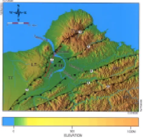
As one of the most prominent geomorphic features in Taiwan, the Taipei Basin has long been a focus of attention in both natural and social sciences. Nearly triangular in shape (Figs. 1 and 2), the Basin is bordered with the Western Foothills to the south and east (Pl. 1A), the Tatun volcanoes to the north (Pl. 1B), and the Linkou Tableland to the west (Pl. 1C). It is occupied by the floodplain of the Tanshui River, which has been developed into the largest and foremost important metropolis of Taiwan, including the capital city Taipei (Pl. 1A).
Figure 1. Geomorphic features of the Taipei Basin and its vicinity. Color shading image of Digital Terrain Model. Geology and symbols shown in Figure 2.
117
Teng et al.: Origin of Taipei Basin
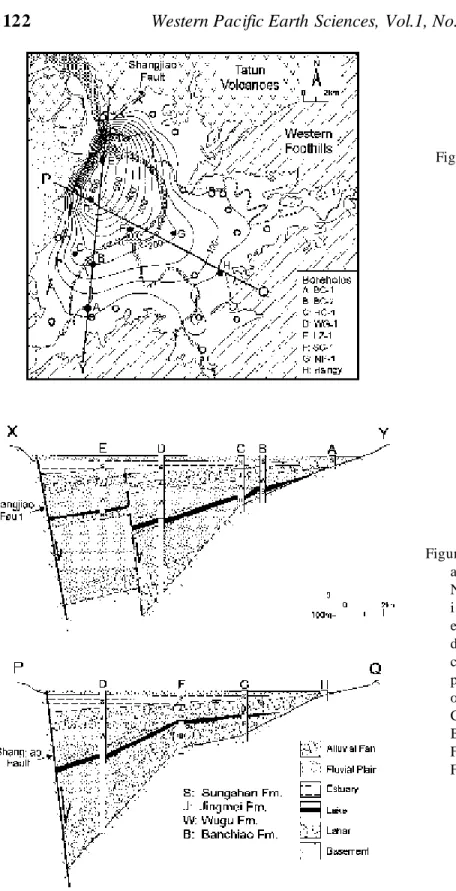
Figure 2. Geological setting of the Taipei Basin. Note that both Hsingchuang and Chinshan Faults are ove rprin ted b y ex tensi onal struc tures and a rift ba sin u nderl ies t he Ta tun v olca nics. Top map modified from Ho (1986); Section A-A' from Chu et al. (1998).
118
Western Pacific Earth Sciences, Vol.1, No.2
Plate 1. Geological environment of the Taipei Basin.
A. Taipei Basin, Western Foothills, and Hsuehshan Range. (view to the south from Tatunshan) B . Tatu n volc anic area. The vo lcani c cone in th e cen ter is Shamaoshan . (vie w to southe ast from
Tatun shan)
C. Taipei Basin, Shangjiao Fault, and Linkou Tableland. Note the segmented pattern of the Shangjiao Fault; details shown in Figure 11. (view to south from Tatunshan)
D. Deformed Tertiary strata and overlying Tatun volcanics at Kueizekeng. The recumbent fold at lower righ t is composed o f the Ol igocene Wuchihshan Formation. Height of the scarp is about 5 0 m. (Location shown in Figure 2)
E. Chihshingshan, the highest volcano in the Tatunshan area (1120 m). The fault scarp pertains to the West Chihshingshang Fault (Chen and Wu, 1971), one of the normal faults along the Chinshan Fault (Chu et al., 1998). Note fumaro les on the flank. (view to east from Tatunshan; location shown in Figure 2)
F. The lateritic topsoil and Quaternary gravel of the Linkou Tableland. (Figure at the lower left for scale; location shown in Figure 2)
Teng et al.: Origin of Taipei Basin
119
To geologists and geographers, the origin of the Taipei Basin has been a subject matter of interest and conjecture. Deguchi (1912) was the first to speculate that the Basin formed by the collapse of the subsurface vacancy left by the Tatun volcanic eruptions. Makiyama (1933) interpreted the Basin to be a drained lake that was dammed up by the pyroclastic deposits at Kuandu. Tan (1939) proposed that the Taipei Basin formed by the downfall of hangingwall along the Shangjiao Fault. Wang Lee et al (1978) maintained that the Basin was a mountainous terrain that was first thrust upon the Linkou Tableland and then slid down into a depression. Lu
et al. (1994) related the development of the Taipei Basin to the continuing bending of the
crescent Taiwan mountain belt. Lee et al. (1999) interpreted the Taipei Basin as a divergent fault wedge formed by the sinistral displacement along the Hsingchuang Fault.
In view of the arguments posed by previous workers, it appears that the hypotheses of Deguchi (1912) and Makiyama (1933) are highly speculative for short of rigorous evidence. Makiyama's dammed-lake hypothesis, though having gained some support (e.g., Chen, 1953; Chang, 1971), was refuted by Tan (1939) and later became discredited (e.g., Lin, 1957; Shi et
al., 1996; Wang Lee et al., 1978). Tan's (1939) tectonic-depression hypothesis that stemmed
from a solid geological analysis has been well received by later workers (e.g., Chen, 1953; Lin, 1957; Wang Lee et al., 1978; Wu, 1987). Wang Lee et al. (1978) modified Tan's hypothesis and illustrated the geological history of the Taipei Basin with a series of figures, which have been regarded as a norm in the past 20 years (e.g., Wu, 1987; Shi et al., 1996). Lu et al. (1994) and Lee et al. (1999) sought for a structural interpretation for the Taipei Basin in the context of regional tectonics but did not give a clear account of its geological history.
In the past 15 years, we have been engaged in various topics of research on the tectonics and geology of northern Taiwan and have participated in the recent deep drilling projects in the Taipei Basin (Chen and Teng, 1990; Chu et al., 1998; Lee and Wang, 1988; Peng et al., 1999; Teng, 1996, 1997, 1998; Teng and Lee, 1996; Teng et al., 1992, 1999). Based on our working experience, we found that some of the critical arguments about the geological evolution of the Taipei Basin are yet to be resolved. For instance, was the Basin formed by normal displacement along the Shangjiao Fault (Tan, 1939)? Or by wrench activities of the Hsingchuang Fault (Lee
et al., 1999)? When the alluvial gravel of the Linkou Tableland was deposited, was the Basin
part of the alluvial plain as alluded to by Tan (1939)? Or was it a mountain range thrust upon the Tableland (Wang Lee et al., 1978)? Has the Basin ever been dammed as Makiyama (1933) suggested? We also found that a number of issues crucial to the origin of the Taipei Basin have not been fully expounded. For example, how did the mountains and volcanoes around the Basin form? How do they relate to each other? What are the mechanisms for faulting and basin subsidence? In an attempt to address the above questions and improve our understanding of the Taipei Basin, we integrated our research results with other information to establish a comprehensive synthesis. We first outline the tectonic and geologic background of the Taipei Basin and explore a geodynamic mechanism for its formation. We then summarize the stratigraphical and structural data to construct a chronologically constrained model of its evolution. At the end, we discuss the arguments posed by previous workers and sort out the unsolved problems for future study.
REGIONAL BACKGROUND
From the geomorphology point of view, the Taipei Basin and its environs can be divided into 4 parts: the Western Foothills to the south and east, the Tatun volcanic area to the north, the Linkou Tableland to the west, and the Basin enclosed in the center (Figs. 1 and 2). The Western
Western Pacific Earth Sciences, Vol.1, No.2
120
Foothills and conterminous Hsuehshan Range are comprised of northeast-trending ridges and valleys with altitude increasing toward the southeast (Pl. 1A). These mountain ranges are underlain with deformed Tertiary strata stacked in northwest-facing folds and thrust sheets (Ho, 1974, 1983).
The Tatun volcanoes consist of more than 20 andesitic edifices of Pliocene-Pleistocene age (Pls.1B and E; Chen and Wu, 1971; Song et al., 2000). The volcanoes sit on top of a sedimentary basement that crop out in the periphery of the Tatun area (Pl. 1D) and was attested in the center by drilling (Chen and Wu, 1971). The top of the basement deepens from the periphery toward the center, where a rift basin is believed to underlie the volcanics (section A-A', Fig. 2; Chen, 1975; Song et al., 2000). The Chinshan Fault cuts across the Tatun volcanic area and divides the basement into two parts; the deformed Oligocene-Lower Miocene strata in the southeast and the less deformed Upper Miocene and Pliocene rocks in the northwest (Ho, 1983; Yen et al., 1984). Despite the obvious thrust offset in the basement rock, the Fault does not produce a continuous rupture through the overlying volcanics but is associated with an array of normal and strike-slip faults (Pl. 1E; Chen and Wu, 1971; Chu et al., 1998; Huang et
al., 1991).
The Linkou Tableland is a heavily dissected terrace 220-250 m high (Fig. 1; Pl. 1E). It is capped with lateritic soil and underlain by flat-lying Pliocene-Pleistocene conglomerates, sandstones, and mudstones (Pl. 1F). Its northern part is intruded and covered with andesitic to basaltic rocks akin to the Tatun volcanics (Chen, 1989; Hwang and Lo, 1986; Tien et al., 1995). Its eastern edge is a linear scarp affiliated with the Shangjiao Fault (Tan, 1939; Chen, 1953; Lin, 1957).
The Taipei Basin is floored with a deformed Tertiary basement and filled with flat-lying Quaternary sediments (section B-B' in Figure 1). The basement rocks, as revealed by boreholes (Pl. 2A), are lithologically and stratigraphically similar to the folded and faulted strata of the Western Foothills (Teng et al., 1999; Wang Lee et al., 1978; Wu, 1965). The Quaternary basin-fill deposits consist of interbedded alluvio-lacustrine gravel, sand, and mud, and some volcaniclastics (Pls. 2B-F). The depth of the basement increases from the basin margin toward its northwest corner (Figs. 3 and 4), where it reaches a depth of 670 m (Chao-Hsia Chen, personal communication). The geometric configuration of the Tertiary basement and overlying sediments shows that the Basin is a half-graben abutting against the Shangjiao Fault (Fig. 4).
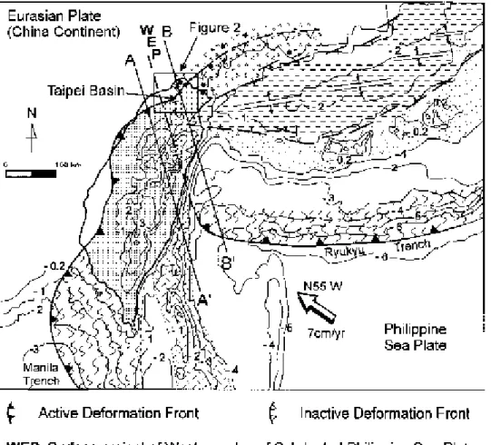
Seemingly complex and segmented, the geology of the Taipei Basin and its surrounding area can be better elucidated with reference to regional tectonics. As shown in Figure 5, the Basin is located in the northern tip of the Taiwan Mountain belt, which was formed by collision between the Luzon arc and the China continent in the past 10 m.y. (Ho, 1986; Teng, 1990). The collision deformed the sedimentary sequences of the China continental margin into the folded and faulted Tertiary strata of the Western Foothills and Hsuehshan Range. Judging by the distribution of these deformed Tertiary strata (Fig. 2), the mountain belt should have been larger than the extant mountain ranges and included the entire region east of the Chinshan and Hsingchuang Faults (Ho, 1982). This endorses Wang Lee et al's (1978) view that the Taipei Basin area was part of a rising mountain belt, which was thrust upon the Linkou area along the Hsingchuang Fault.
To explain that the deformed Tertiary basement is buried beneath the Taipei Basin (Fig. 4), it is necessary to note that the northeastern Taiwan orogen, (the area east of WEP in Figure 5) including the Taipei Basin , has evolved beyond the collisional stage and is in the process of collapsing (Teng, 1996). This part of the mountain belt went through the collision in Pliocene and early Pleistocene time but has left the collision zone after the subduction polarity flipped in late Quaternary time (Suppe, 1984; Teng, 1996). Presently this part is subjected to extension
121
Teng et al.: Origin of Taipei Basin
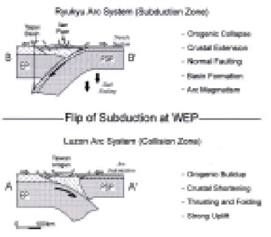
associated with the southeast-facing Ryukyu Arc system, in contrast with the rest of Taiwan, which is undergoing compression exerted by the northwest-facing Luzon Arc system (Figs. 5 and 6). Before the subduction polarity switched, the Taipei Basin area was probably a hilly terrain like the frontal part of the rising orogen in south-central Taiwan (A-A' of Figure 6). As soon as the polarity flipped, the collision was terminated, and the Ryukyu arc magmatism was initiated. The mountain belt collapsed in response to extension, and its frontal part subsided as the Taipei Basin (B-B' of Figure 6).
Plate 2. Core photos of the Tertiary basement and Quaternary sediments, Taipei Basin. (Borehole locations shown in Figure 3; stratigraphy in Figure 9)
A.Deformed Tertiary basement. Note the inclined sandstone/shale interbeds. B.Coarse-grained cobbles of the alluvial fan facies.
C.Interlayering pebbles and sands of the fluvial plain facies. D.Interlayering muds and fine-grained sands of the estuarine facies. E.Laminated mud of the lacustrine facies.
122
Western Pacific Earth Sciences, Vol.1, No.2
Figure 4. Facies characteristics a nd b asi n co nfig u ra ti on . Note the inferred normal fault i n se c t i o n X-Y a n d t h e ex ag ge ra te d th ic kn ess of dee p-lak e dep osits. Fac ies charact eristics of th e lower part of Borehole D are based o n u n p u bl i sh e d d a t a o f Central Geological Survey. Borehole locations shown in Fig ure 3; stra ti grap hy i n Figure 9.
Figure 3. Sedi ment thic kness an d boreh ole l oc ati on s. Contours in m; sections P-Q and X-Y shown in Figure 4 ; st rat ig ra p hy o f d ee p boreholes (solid circles) in F i g u r e 9 ; u n n a m e d bo reh ole s (op en circle s) e x c e rp t e d fro m Pe n g (1998).
Teng et al.: Origin of Taipei Basin
123
Figure 5. Tectonic framework. WEP separates the Taiwan area into the Luzon Arc system in the southwest and the Ryukyu Arc system in the northeast. The Taipei Basin is located in the collapsing orogen of northeastern Taiwan and is affiliated with the Ryukyu Arc. Modified from Teng and Lee (1996); sections A-A' and B-B' shown in Figure 6. Contours in km.
124
Western Pacific Earth Sciences, Vol.1, No.2
STRATIGRAPHIC RECORDS
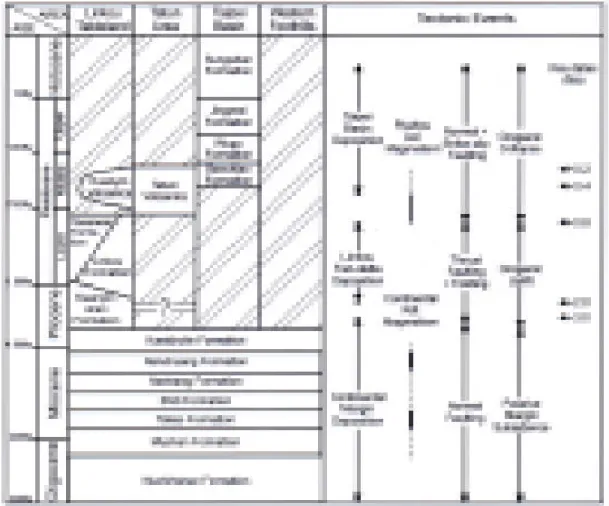
The techonic history outlined above can be traced back to the early Tertiary as recorded in the Oligocene-Miocene strata underlying the Taipei Basin (Fig. 7). These strata, composed of coastal to shallow-marine sandstones and mudstones with minor coal seams (Chou, 1973, 1980; Ho, 1986; Yu and Teng, 1996; Tai et al., 1994), were the sedimentary cover of the pre-collisional China continental margin (Teng, 1992). Intercalated in these siliciclastic deposits are sporadic basaltic volcanics produced by magmatism associated with the stretched continental lithosphere (Chen, 1990; Chung et al., 1995).
Figure 6. Geodynamic configuration. Upper panel shows that the Taipei Basin sits on the frontal part of the collapsing orogen with arc magmatism in the north. Before the subduction polarity flipped, the orogen underlying the Basin was part of the rising orogen similar to that of the active collision zone shown in the lower panel. EP: Eurasian plate; PSP: Philippine Sea plate. Modified from Teng and Lee (1996); locations shown in Figure 5.
125
Teng et al.: Origin of Taipei Basin
The Pliocene-Pleistocene strata of the Linkou Tableland, though not involved in the deformation, preserve an important sedimentary record of the orogenic history in northern Taiwan. These strata can be divided into two coeval rock units: the gravel-dominated Linkou Formation in the east and a sand-and-mud-rich Tananwan Formation in the west (Pls. 3A-D). According to Chen and Teng (1990), the Linkou-Tananwan strata were accumulated in a fan-delta system lying in front of a mountain range that occupied the present Taipei Basin area (Fig. 8). The presence of the mountain range is supported by the lack of Pliocene-Lower Pleistocene deposits in the Taipei Basin and Western Foothills (Fig. 7). The sediment of the Linkou fan-delta was derived from the Western Foothills and Hsuehshan Range and was brought in by the ancient Hsintien (Ichikawa, 1929; Wang Lee, 1969) and Keelung Rivers (Hanai, 1930; Tien et
al., 1995). Since the fan-delta was fed by a point source (Fig. 8), the ancient Keelung and
Hsintien Rivers must have merged as the Paleo-Tanshui River before leaving the mountains (Chou and Teng, 1999).
Western Pacific Earth Sciences, Vol.1, No.2
126
Plate 3. Outcrop exposures of Linkou-Tanawan fan-delta deposits and the Kueishan strata. A. Gravels of the fan apex facies, the Linkou Formation. Note the horizontal bedding (Bd) and pebble imbrication (Im). (Location shown in Figure 8)
B. Thick gravel and Interlayering sand of the upper fan facies, Linkou Formation. Cliff height is about 80 m. (Location shown in Figure 8)
C. Gravel and cross-bedded sand of the middle fan facies, Linkou Formation. (Location shown in Figure 8)
D. Interlayering sand and mud of the lower fan facies, Tananwan Formation. Note the thin-bedded pebble (Pb) in the upper section. (Location shown in Figure 8)
E. Kueishan strata and Hsingchuang Fault. The nearly vertical Kueishan strata (KC) are deformed in a duplex and thrust upon the flat-bedded Linkou Gravel (LG). The Kueishan strata consist of interlayering sandstones and mudstones in the upper deck and of pebble conglomerates in the lower deck. The thrust marks the surface trace of the Hsingchuang Fault. (Location shown in Figure 11)
F. Deformed Kueishan strata. Note the nearly vertical bedding, intense fracturing, and displacement along minor thrusts. (Location shown in Figure 11)
Teng et al.: Origin of Taipei Basin
127
Though remaining mostly flat, part of the Linkou-Tananwan strata is tilted by igneous intrusions in the Kuanyinshan area north of the Tableland, where underlying marine shales are exposed (Chen, 1989; Ho, 1969). These tilted strata, collectively termed the Kuanyinshan Formation by Makiyama (1935), form a coarsening-upward succession ranging from marine shales, sandstone/shale interbeds to conglomerates. This coarsening-upward succession is equivalent to the foreland basin deposits of central and southern Taiwan that record the uplift history of the collisional orogen (Teng, 1987). Though not fully exposed, the base of Kuanyinshan is, at least, as old as 3 Ma according to magnetostratigraphic analysis (Lee et al., 1995). The youngest age of Kuanyinshan can be inferred from the Linkou-Tanawan strata, which are equivalent to the middle and upper part of the Kuanyinshan Formation (Ho, 1969; Chen, 1989). Tseng et al. (1992) interpreted the top of Tananwan to be 0.7 Ma or younger on the basis of palynostratigraphic analysis. Paleomagnetic data of Lee and Chou (1995), however, demonstrate that the red soil atop the Tananwan pertains to the Matuyama epoch, which should not be
Fig ure 8 . Lin k ou fa n-d el ta . Upper panel displays facies pa tt ern; l ower p an el t he i n fe rr e d d e p o si t i o n a l se tti ng. A, B, C, D i n t he up pe r p an el ind ic ate t he locations of photos shown in Plate 3. M odified from Chen and Teng (1990)
Western Pacific Earth Sciences, Vol.1, No.2
128
younger than 0.7 Ma. The disparity can be resolved if the age of red soil is set at about 0.8 Ma, which is consistent with the age of the overlying Kuanyinshan volcanics dated 0.2 to 0.6 Ma (Juang and Chen, 1989; Tien et al., 1995). Hence the orogenic uplift in the Taipei Basin area, as implied by the foreland deposition of the Linkou Tableland, was initiated at about 3 Ma and terminated at around 0.8 Ma (Fig. 7). This is generally contemporaneous with the morphogenic phase of the collisional orogeny inferred from other lines of evidence (Teng, 1990). Nevertheless mountain building in this area probably did not reach its climax until around 2 Ma when the Linkou gravel began to accumulate.
Emplacement of andesitic volcanics in the Tatun area marks the onset of Ryukyu arc magmatism and the flipping of subduction polarity (Teng et al., 1992). Fission-track and K-Ar and dates indicate that the ages of the Tatun volcanics range from 0.8 to 0.2 Ma, with a few between 1.3-2.8 Ma (Juang and Chen, 1989; Song et al., 2000; Tsao, 1994; Wang and Chen, 1990). Owing to the intrinsic analytical uncertainties and the lack of stratigraphic check, the available dates are not entirely self-consistent and need to be interpreted with caution (Tsao, 1994). Especially those of 1.3-2.8 Ma, which are inferred as volcanisms produced in the late stage of the collisional orogeny (Song et al., 2000; Teng et al., 1992), are reported from isolated sites where the reliability of sampling and reproducibility of experimental data require further scrutiny. However, those 0.8-0.2 Ma dates are widespread and reliable, and are clearly indicative of post-orogenic magmatisms (Teng et al., 1992).
The onset of sedimentation in the Taipei Basin implies that the basement had lowered to near sea level so that sediments could fill in. The time of the onset, however, is hard to ascertain, because the base of the basin deposits is not well dated. Borehole data show that the thickest as well as the oldest sediment is buried in the northwestern part of the Basin, where a deep borehole WG-1 has been drilled (site D, Fig. 3). Chen et al. (1995) obtained an Ar-Ar age of 0. 4 Ma from a volcaniclastic layer in the lower part of WG-1, which, however, contradicts with Wei et al.'s (1998) thermoluminescence age of 0.2 Ma for the sediment beneath (Fig. 9). Since Chen et al.'s date was obtained from detrital hornblende grains, it probably reflects the age of its source rather than the age of deposition. In the neighboring LZ-1 borehole (site E, Fig. 3), a correlative vocaniclastic layer was dated 0.2 Ma with K-Ar radiometry (Tsao, 1997), which is consistent with the results of thermoluminescence analysis. Nevertheless, the date 0. 2 Ma does not truly reflect the oldest age of the sediment, because the borehole did not reach the basement. Accepting the thickness estimation of Wang et al. (1995) and extrapolating the subsidence rate of the upper sediment column, Wei et al (1998) postulated that the bottom of WG-1 should not be older than 0.3 Ma. However, recent drilling at WG-1 demonstrated that the sediment thickness is 670 m (Chen, C. H., personal communication), much thicker than the 450 m proposed by Wang et al. (1995). Hence the age of the basal sediment may well be as old as 0.4 Ma following Wei et al.'s (1998) way of extrapolation.
The Taipei Basin sediments include a variety of depositional facies ranging from alluvial fan (Pl. 2B), fluvial plain (Pls. 2C and D), lake (Pl. 2F), to estuary (Peng et al., 1999; Teng et
al., 2000). The sediment facies exhibit a prominent lateral change from alluvial fan-dominated
in the south and east to fluvial and estuarine-dominated in the north and west (Fig. 4). The abundance of alluvial fan deposits in the southeastern part of the Basin demonstrates that the Hsintien and Keelung Rivers have been the major sediment source throughout the depositional history (section P-Q, Fig. 4). In the southwestern corner, however, alluvial fan deposits are rare except in the Jingmei Formation (section X-Y of Figure 4), indicating that the Tahan River did not contribute much sediment until Jingmei was accumulated.
Teng et al.: Origin of Taipei Basin
129
The Taipei Basin sediment also exhibits distinct vertical facies variations, especially in the central and northwestern part (Fig. 4), reflecting environmental changes caused by fluctuating sea level (Teng et al., 2000). Within the varying facies of basin deposits, three persistent sediment units stand out conspicuously (Fig. 9). One is the lacustrine deposit of the upper Banchiao Formation found in most part of the Basin, except near the south and east margins (Fig. 4). It is the only sediment layer characterized by well-developed fine lamination (Pl. 2E), which usually forms in deep anoxic lakes of humid tropical areas. In the northwestern corner of the Basin, the laminated mud is directly underlain with a volcaniclastic bed (Pl. 2F), which is lithologically similar to the lahar deposits exposed in the nearby Tatun volcanoes (Chen et al., 1995; Song and Lo, 1997; Tsao, 1997). The intimate association of the lacustrine mud and the lahar strongly suggests that they are genetically related and, thus, indicative of a dammed-lake event (Teng et al., 1999). This event took place at around 0.2 Ma when the lahar blocked the effluence of the Tanshui River and the Basin was inundated as a deep freshwater lake (Teng, 1998).
Figure 9. Borehole stratigraphy and depositional events. Location and symbols of boreholes shown in Figure 4. Modified from Teng et al. (1998); Radiocarbon dates from Liu et al. (1994); K- Ar dates from Chen et al. (1995) and Tsao (1997); Thermoluminescence dates from Wei et al. (1998)
Western Pacific Earth Sciences, Vol.1, No.2
130
The second distinctive unit is the alluvial fan gravel of the Jingmei Formation that covers the entire Basin (Figs. 4 and 9). This layer reflects an unusual period of basin-wide alluvial fan deposition, which was previously restricted to the southeastern part. In the southwestern corner where the Tahan River enters the Basin (Fig. 3), the Jingmei gravel is the only alluvial fan deposit preserved (section X-Y of Fig ure 4). The in flux of alluvial fan gravels into the southwestern corner of the Basin is obviously attributed to the Tahan River, which did not flow into the Basin until being diverted at about 30 ka (Chen et al., 1990; Chen and Liu, 1991). It appears believed that the large amount of coarse-grained sediments brought in by the Tahan River had resulted in construction of composite alluvial fans over the entire Basin (Teng, 1997). Another distinctive unit is the estuarine deposit of the middle Sungshan Formation (Pl. 2D), which contains abundant marine to brackish-water mollusks and foraminifers (Tan, 1938; Huang, 1962). Its wide coverage (Figs. 4 and 9) indicates that the Basin was deeply invaded by marine transgression and became a brackish-water bay in early Holocene time (Lin, 1957; Huang, 1962).
STRUCTURAL EVIDENCE
From the above tectono-stratigraphic analysis, it is clean that the Taipei Basin is a late Quaternary half-graben affiliated with the Shangjiao Normal Fault ( Fig. 4). However, as marked in previous geological maps (e.g., Ho, 1983, 1986; Huang, 1981), the Taipei Basin and its surrounding area is characterized by northeast-trending folds and thrusts parallel to the structural grain of the collisional orogen. Some of the major thrust faults, like Hsingchuang, Kangjiao, and Taipei, either cut across the Basin or run through the margin (Fig. 10). These contractional structures are formed by the northwest-directed tectonic stress of the collisional orogeny (Angelier et al., 1986, 1990; Ho, 1974, 1982).
Figure 10. Structural features. Sec ti on s X-Y an d P-Q sho wn in Figure 4. Mo-d ifie Mo-d from Ho (19 74 , 198 3); Inferred faults f-ro m W a n g L e e e t a l . (1978).
Teng et al.: Origin of Taipei Basin
131
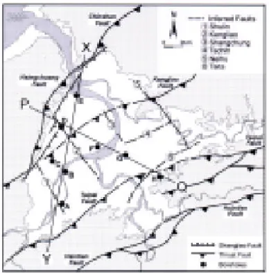
Prominent as they are, whether the fold-and-thrust structures are active is questionable. Taking the Taipei Fault for example, Wu (1978) and Hsu and Chang (1979) regarded it active on the basis of its linearity and distinct fault scarps. However, Ho (1974, 1983) and Wang et al. (1999), observed that the Fault is covered with upper Quaternary sediments of the Taipei Basin, in which no stratigraphic offset can be discerned. Other thrust faults, such as Chinshan, Kangjiao, Hsintien, and Chuchih, all fail to demonstrate convincing evidence of Quaternary contraction (Chen and Wu, 1971; Ho, 1974, 1983; Huang, 1996; Huang et al., 1991, 1994). On the other hand, late-stage normal and strike-slip faults are omnipresent, cutting across the fold-and-thrust structures (Huang et al., 1994; Lee et al., 1994; Lee and Wang, 1988; Lu et al., 1994). Although Lu et al. (1994) ascribed all the contractional, transcurrent, and extensional structures to a single episode of deformation associated with oblique collision, earthquake focal mechanisms show that the area is dominated by extension with little sign of contraction (Lee and Wang, 1988; Yeh et al., 1991). All these features indicate that the contractional structures have been deactivated and superimposed by transcurrent and extensional structures (Lee and Wang, 1988; Teng and Lee, 1996).
From the tectonics point of view (Figs. 5 and 6), the change of structural style from contractional to extensional is not surprising. As aforementioned, the northeastern Taiwan area was first subjected to collision in Pliocene and early Pleistocene time and then incorporated into the Ryukyu subduction zone in the late Quaternary. During the transition from collision to subduction, the regional stress field has changed from compressional through transcurrent to extensional (Lee and Wang, 1988; Teng and Lee, 1996). Under this circumstance, it is almost inevitable to have the contractional structures formed by early compression overprinted by later transcurrent and extensional features. Some of the early thrust faults may even have been reactivated into strike-slip or normal faults. This kind of structural inversion has already been observed in the foundered orogen off northeastern Taiwan, where a series of Pliocene thrust faults have been transformed into Quaternary normal and strike-slip faults (Hsiao et al., 1998). In the onshore area, structural inversion is less obvious but still perceivable. The most prominent example is the transformation of the Hsingchuang Thrust Fault into the Shangjiao Normal Fault along the western margin of the Taipei Basin (Figs. 10 and 11). The Hsingchuang Fault is the westernmost thrust fault in northern Taiwan as well as the frontal thrust fault of the collisional orogen (Chiu, 1968; Ho, 1982, 1983; Ichikawa, 1931). It is characterized by a significant stratigraphic offset observable in the Shantzechiao area southwest of the Taipei Basin and in the Kueitzekeng area to the northwest (Fig. 11; Chiu, 1968; Tan, 1943). Between Shantzechiao and Kueitzekeng, comparable stratigraphic offset has also been attested by drilling (Wu, 1965), but the location of the Fault remains conjectural (Chang, 1971; Chiu, 1968; Ho, 1969, 1983; Tan, 1943). Our investigations show that the tip of the Fault may run through the eastern slope of the Linkou Tableland, where blocks of the tilted Miocene-Pliocene strata are located (Pls. 3E and F; Fig. 11). In the past, these deformed strata were thought to underlie the Pleistocene Linkou Formation (Chiu, 1968; Ho, 1969; Lin, 1963; Tan, 1929). However, at some new exposures we found that these strata also overlie the Linkou gravels along a thrust contact (Pl. 3E). In the Shantzechiao area, similar Miocene-Pliocene rocks are found associated with the Hsingchuang Fault and have been termed the Kueishan Formation (Tan, 1929) or Lingting Formation (Chiu, 1968). Though Chiu (1968) put the Hsingchuang Fault on top of the Kueishan rocks and designated a Lingting Fault below, we suspect that the Lingting Fault merges with the Hsingchuang Fault in the subsurface and is the frontal branch of the Hsingchuang Fault. Hence the surface trace of the Hsingchuang Fault, if defined as the westernmost thrust fault, should be demarcated by the western edge of the Kueishan Formation and linked with the thrust fault on the eastern slope of the Linkou Tableland. The fact that the Kueishan rocks are both thrust upon and
Western Pacific Earth Sciences, Vol.1, No.2
132
overlain by the Linkou Gravel implies that the Hsingchuang Fault was active when the lower Linkou Gravel was deposited but later became inactive.
Figure 11. Hsingchuang and Shangjiao Faults. Note that the fault slip data at Shulin and Taishan indicate an early compression followed by extension, whereas those of Kuandu and Wugu show only lateral shear and extension. Geological map modified from Hu and Mao (1996), and Lin (1981); fault slip from Chu (1993) and Lee and Wang (1988); shallow seismic survey from (A) Wang and Lee (1997), (B). Hsieh et al, (1992) and (C) Sinotech (1997)
Teng et al.: Origin of Taipei Basin
133
After the Hsingchuang Fault was deactivated, the hangingwall of the Fault, originally higher than the Linkou Tableland (Fig. 8), must have slid down along the Shangjiao Fault so as to be buried deep in the Taipei Basin (Fig. 4). The Shangjiao Fault has long been inferred to follow the western edge of the Taipei Basin (Chen, 1953; Tan, 1939; Wu, 1965), and that has been substantiated by recent seismic surveys and drillings (Hsieh et al., 1992; Lee, C. T., unpublished data; Wang and Lee, 1997), albeit with a more segmented configuration (Fig. 11). The close association of the Hsingchuang and Shangjiao Faults suggests that Shangjiao was transformed from Hsingchuang with part of the fault surface reactivated (Tan, 1939; Wang Lee et al., 1978; Wu, 1965). The change of stress field that accompanied the Hsingchuang-Shangjiao transformation is supported by the fault slip analysis in the neighboring area (Fig. 11, Chu, 1993).
In addition to the Hsingchuang-Shangjiao couplet, structural inversion can also be observed at the Chinshan Fault of the Tatun area (Fig. 2). The Fault first produced a significant thrust offset in the Tertiary basement before it was covered by the volcanics, and then transformed into a zone of strike-slip and normal faults (Chu et al., 1998). During the transformation, the Tertiary basement may have collapsed into a rift basin (section A-A' in Figure 2).
EVOLUTIONARY HISTORY
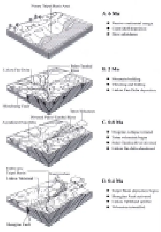
Summarizing the tectonic and geologic information (Fig. 7), it is clear that the Taipei Basin and its surrounding area was part of the China continental shelf that had been subsiding and accumulating sediments throughout Oligocene-Miocene time. The depositional environments of this region shifted between coastal to offshore but mostly stayed in the shallow sea (Fig. 12A).
As the collisional orogeny commenced in late Pliocene time, the continental shelf was tectonized into mountain ranges, and its sedimentary cover deformed into imbricated folds and thrust sheets. At about 2 Ma, the collision orogeny reached the climax and pushed the mountain ranges to thrust over the Linkou and northwest Tatunshan areas along the Chinshan and Hsingchuang Faults (Fig. 12B). The Paleo-Tanshui River drained through the rising mountain ranges and laid down the Linkou fan-delta in front.
When the subduction polarity flipped beneath northeastern Taiwan in late Quaternary time, the collisional orogeny ceased, and the Tatun volcanism commenced. The mountain ranges of the Tatun area collapsed into a rift basin as the Chinshan Fault was reactivated into strike-slip and normal faults. At about 0.8 Ma, deposition of the Linkou fan-delta ceased (Fig. 12C), implying that the Paleo-Tanshui River no longer supplied sediment. What happened to the Paleo-Tanshui River remains unknown. We suspect that it was diverted northward into the rift basin of the Tatun area, as the way the Tahan River was later captured into the Taipei Basin. From 0.8 Ma to 0.4 Ma, volcanism thrived in the Tatun and Kuanyinshan area and built up piles of andesitic cones. The Hsingchuang Thrust Fault in the Taipei area was reactivated into the Shangjiao Normal Fault, and the deserted Linkou fan-delta on the footwall was elevated into a tableland (Fig. 12D). The mountain ranges on the hangingwall subsided as a depression, which became a sediment-receiving basin at about 0.4 Ma.
From 0.4 Ma to the present, the basin has kept expanding as subsidence and sedimentation continued. The basin has been covered with lluvial fans, fluvial plains, and estuaries, which have waxed and waned with the fluctuating sea level. At around 0.2 Ma, the basin was inundated as a lake when a lahar derived from the Tatun volcanoes blocked the effluence of the Tanshui River (Fig. 12E). When the Tahan River was diverted into the Basin at about 30 Ka, the Basin
Western Pacific Earth Sciences, Vol.1, No.2
134
was choked with gravelly sediment and covered with composite alluvial fans (Fig. 12F). In early Holocene time, the basin was invaded by marine transgression and turned into a brackish-water bay, which accrued to its maximum at around 6 Ka (Fig. 12G). Continued alluvial sedimentation eventually filled up the bay and achieved the present configuration of the Taipei Basin (Fig. 12H).
Teng et al.: Origin of Taipei Basin
135
Western Pacific Earth Sciences, Vol.1, No.2
136
DISCUSSIONS
Upon completing the synthesis, we found that our interpretations are to various extent consistent with those proposed by previous workers, but with significant disparities. We agree with Makiyama (1933) that the Basin was once dammed into a lake but do not accept his inference that the lake was manifested with the estuarine sediments of the Holocene Sungshan Formation. We endorse Tan (1939), Lin (1957), and Huang (1962) that the Basin has not been isolated from the sea since the early Holocene and maintain that the dammed lake was formed in middle Pleistocene time as indicated by the laminated mud of the Banchiao Formation (Figs. 9 and 12E). We concur with Tan (1939) that the Taipei Basin is associated with the down-sliding hangingwall of the Shangjiao Fault but disagree on his interpretation that the Linkou Gravel is correlatable with the subsurface gravels of the Taipei Basin. We believe that the subsurface gravels of Taipei are younger than the Linkou gravel (Fig. 7) and support Wang Lee et al's (1978) view that the Taipei Basin was a mountainous terrain when the Linkou Gravel was deposited (Fig. 8). However, we do not think that the Linkou gravel was a coastal deposit as proposed by Wang Lee (1969) and Wang Lee et al (1978), but interpret it as a fan-delta (Fig. 8). We disapprove of Lu et al's (1994) inference that the Taipei Basin was formed by syn-orogenic extension, instead we deem it a post-orogenic product (Fig. 6).
With the above issues resolved, there some questions pending. For instance, we are not sure if subsidence of the Taipei Basin is directly related with Tatun volcanism as Deguchi (1912) speculated. In our model, there is no obvious causality between Tatun volcanism and Taipei Basin subsidence, although both resulted from the late Quaternary polarity reversal (Figs. 5 and 6). Nevertheless, we cannot rule out the possibility that the Taipei Basin might have spasmodically subsided in response to Tatun volcanisms as Song et al (2000) proposed for the rift basin of the Tatun area.
We also cannot dismiss the role of wrench tectonics in the formation of Taipei Basin as stressed by Lee et al. (1999). We acknowledge the notion that wrench tectonics may be important during the transition from orogenic buildup to orogenic collapse (Teng and Lee, 1996) and realige the fact that the Shangjiao Fault is associated with horizontal slip (Chu, 1993; Lee and Wang, 1988). However we doubt that wrench tectonism was ever significant, since no obvious markers indicative of strike-slip offset can be recognized. We believe that strike-slip faulting was transient and did not generate much displacement. The Taipei Basin formed mainly by normal faulting.
We have also noted that Wang Lee et al. (1978) proposed a number of scattered faults in the Basin (Fig. 10) but are not able to evaluate their validity because no relevant information was published. So far, the borehole information is too sparse to confirm any intrabasinal faults (e.g., P-Q of Figure 4), except some inferred from drastic stratigraphic changes (e.g., X-Y of Figure 4). Whether the intrabasinal faults exist and have had any effects over the basin subsidence is an open question. Nonetheless, it seems that the Shangjiao Fault alone is capable of creating the half-graben Taipei Basin (Fig. 4).
The most dubious part of our model is the northward diversion of the Paleo-Tanshui River inferred from the abandonment of the Linkou fan-delta at around 0.8 Ma (Fig. 12C). We believe the Linkou fan-delta was abruptly deserted because the upper fan gravel is directly capped with the topsoil without any indication of progressive channel shifts (Pl. 1F). The Paleo-Tanshui River must have been rapidly diverted in order not to feed sediment to the fan-delta. Since the River could not possibly flow to the high mountains in the east and south, it could only be directed to the north into the rift basin of the Tatun area. This implies that a deep river
Teng et al.: Origin of Taipei Basin
137
channel is buried in the northwestern corner of the Taipei Basin and beneath the Tatun volcanics. So far, no direct evidence for the buried channel is availale. However, buried channels have been proposed to underlie the Tatun volcanics north of Tanshui based on gravity survey (Tzou and Yu, 1987; Yang et al., 1994), and boulders derived from the Central Range were found embedded in the Tatun volcanics (Tan, 1931; Wang and Chen, 1990). These seem to support that the Paleo-Tanshui River did flow through the Tatun area and part of its sediment was captured by later volcanic eruptions. This issue remains to be investigated. The proposed buried channel in the northwestern Taipei Basin and the Tatun area can be tested with future drilling. Limited by the borehole information (Fig. 9), the depositional history of the Taipei Basin can only be deciphered rudimentarily with many important issues remaining less than clear. For instance, the oldest sediments of the Taipei basin, which are crucial in timing the initiation of basin sedimentation, have not been properly dated. The dammed-lake event, which caused a catastrophic flooding in the Basin, needs to be substantiated with more stratigraphic data, and the dimension and development history of the lake remains to be ascertained. The other two events, the Jingmei alluvial fan and the mid-Sungshan estuary, also require further study to reveal their detailed histories. With more data coming out of recent deep drillings (e.g., Lin and Chen, 2000), these issues are likely to be better understood in the near future.
CONCLUSIONS
The Taipei Basin is located at the northern tip of the Taiwan mountain belt, which was formed by collision between the China continent and the Luzon Arc in Pliocene-Quaternary time. Prior to the collision, the Basin and its environs were part of the subsiding continental shelf, which was later deformed into a mountain range around 2 Ma. At about 0.8 Ma, the subduction polarity flipped in northeastern Taiwan so that the collisional orogeny was terminated and the mountain range began to collapse. Ryukyu arc magmatism set in and produced massive andesitic volcanics in the Tatun area. The Hsingchuang Thrust Fault at the west front of the mountain range was transformed into the Shangjiao Normal Fault, and the mountain range on the hangingwall slid down into a depression. At about 0.4 Ma, sediment began to accumulate in the depression, and the Taipei Basin germinated. Since then the Basin has kept expanding as subsidence and sedimentation continued. Throughout its depositional history, the Basin has been dominated by alluvial fans, fluvial plains, and estuaries, which have waxed and waned with the fluctuating sea level. At around 0.2 Ma, the Basin was dammed up as a deep fresh-water lake by a pyroclastic flow from the Tatun volcanoes. As the Tahan River was diverted into the Basin at 30 Ka, it brought in a large amount of gravelly sediment that laid down huge alluvial fans over the entire Basin. In early Holocene time, the Basin was inundated by marine incursion and turned into a brackish-water bay, which was eventually filled up to its present configuration.
ACKNOWLEDGMENTS
We are grateful to Professors Peter B. Yuan, Pei-Yuan Chen, Chih-Ming Wang Lee, Ping-Mei Liew, and Yu-Gau Chen for critical review and comments. Louis Teng wishes to thank the Director of the Central Geological Survey, Mr. Chao-Hsia Chen, for continuous support in the study of the Taipei Basin and offering useful information. Thanks are due to Drs.
Western Pacific Earth Sciences, Vol.1, No.2
138
Sheng-Rong Song and Shuhjong Tsao for beneficial discussions, Messrs. Y. H. Lin and L. Y. Hsiao, L. F. Yue, and Misses S. R. Chang and H. L. Hsu for assistance in typing and drafting. Financial support by the National Science Council is gratefully acknowledged.
We would like to pay a special tribute to Professor Yuan Wang, on the occasion of his retirement, for his inspiring teaching that guided us cheerfully into the realm of geology years ago.
REFERENCES
Angelier, J., Barrier, E. and Chu, H. T. (1986) Plate collision and paleostress trajectories in a fold-thrust belt : the fo othills of Taiwa n: Tect onophysics, 12 5, 161-178.
Angelier, J., Bergerat, F., Chu, H. T., and Lee, T. Q. (1990) Tectonic analysis and the evolution of a curved col lision belt : the Hsueh shan Range, nort hern Taiwan : Tec tonop hysi cs, 18 3, 77 -96.
Chang, S. S. L. (1971) Subsurface geologic study of the area from the Taipei Basin to the Kuanyin shelf, T ao y u an , T aiw an : Petrol. Geol. Taiwan, 9, 123-144.
Chen, C. H. (1953) Taipei Basin: Its structure and formative factors: Academic Review, 2(1), 88-92. (in Chinese)
Chen , C. H. (1975) Thermal wate rs in Taiwan, a preli minary y stud y: Int ernati onal Assoc iation of
Hydrological Sciences, Publication, 9, Proceedings of Grenoble Symposium, August, 1975, 79-88.
Chen, C. H. and Wu, Y. T. (1971) Volcanic geology of the Tatun geothermal area, northern Taiwan: Proc.
Geol. Soc. China, 14, 5-28.
Chen, C . H. (1990) Ig neous Rocks o f Taiwan: Cent ral Geologica l Survey, MOEA, Taipei, 137 p. (in Chinese)
Chen, C. H., Lee, C. Y. and Lin, S. B. (1995) The eruption age of volcanic ashes in the Wuku Well, Taipei Basin: constraints on mineral chemistry and 40Ar/39Ar dating: J. Geol. Soc. China, 38, 371-382.
Chen, W. F. (1989) Stratigraphical and sedimentological study of the Linkou Gravel: unpub. MS thesis, Institute of Geology, National Taiwan University, Taipei, Taiwan, 74 p. (in Chinese)
Chen, W. F. and Teng, L. S. (1990) De positional environment of Quaternary deposi ts of the Linkou Tableland, northwestern Taiwan: Proc. Geol. Soc. China, 33, 39-63.
Chen, Y. G., Liu, T. K., and Wang, Y. (1990) C14 dating and sedimentary environment of a buried valley in
the lower reach of the Tahanchi: Ti-Chih, 10(2), 147-156. (in Chinese)
Chen, Y. G. and Liu, T. K. (1991) Radiocarbon dates of river terraces along the lower Tahanchi, northern Taiwan: Their tectonic and geomorphic implications: Proc. Geol. Soc. China, 34, 337-347. Chiu, H. T. (1968) The Hsingchuang Fault in the Taoyuan area, northern Taiwan: Proc. Geol. Soc. China,
11, 60-73.
Chou, J. T. (1973) Sedimentology and paleogeography of the Upper Cenozoic System of western Taiwan:
Proc. Geol. Soc. China, 16, 111-143.
Chou, J. T. (1980) Stratig raphy and sedimen tology of the Mi ocene in western Taiwan: Petrol. Geol.
Taiwan, 17, 33-52.
Chou, S. W. and Teng, L. S. (1999) On the piracy of the Keelung River: Ti-Chih, 18(2), 1-18. (in Chinese) Chu, C. J. (1993) Pa leostress analy sis of t he Chinshan faul t: Unpu bl. MS. Thesis, Nati onal Ta iwan
Teng et al.: Origin of Taipei Basin
139
Chu, C. J., Lee, C. T. and Teng, L. S. (1998) Structural features and Quaternary tectonics of the ChinshanFault, northern Taiwan: J. Geol. Soc. China, 41, 25-42.
Chung, S. L., Yang, T. F., Lee, C. Y. and Chen C. H. (1995) The igneous provinciality in Taiwan: consequence of continental rifting superimposed by Luzon and Ryukyu subduction systems: J. SE Asian Earth
Sci., 11, 73-80.
Deguchi, Y. (1912) Repo rt of the investigation on the Daiton volcano group: Burea u of Produ ctive
Industries (Government-General of Taiwan), 102p. (in Japanese)
Hanai, S. (1930) Active faults in the Toen Hill, Formosa: Geograph. Rev. Japan, 6(7), 778-789. (in Japanese) Ho, C. S. (1974) The Taipei faul t and related structural features in northe rn Taiwan: Proc. Ge ol. Soc.
China, 17, 95-109.
Ho, C. S. (1969) Some stratigraphic-structural problems of the Linkou terrace in northern Taiwan: Proc.
Geol. Soc. China, 12, 65-80.
Ho, C. S. (1982) Tectonic evolution of Taiwan-Explanatory text of the tectonic map Taiwan: Central
Geological Survey, MOEA, Taipei, 126 p.
Ho, C. S. (1983) Geologic structures and coal fields in the area between Keelung and Tachi, Taiwan: Bull.
Cent. Geol. Surv., 2, 17-70 (in Chinese).
Ho, C. S. (1986) An introduction to the Geology of Taiwan: Explanatory Text of the Geologic Map of Taiwan: Central Geological. Survey, MOEA., Taipei, ROC, 163p (in Chinese).
Hsiao, L. Y., Lin, K. A., Huang, S. T. and Teng, L. S. (1998) Structural chara cteristics of the southern Taiwan-Sinzi folded zone: Pertrol. Geol. Taiwan, 32, 133-153. (in Chinese)
Hsieh, C. H., Chang, Y. F., and Sun, R. H. (1992) Seismic investigate Hsin-Chuan Fault on the west of Taipei Basin: Ti-Chih, 12(1), 13-26. (in Chinese)
Hsu, T. L. and Chang, H. C. (1979) Quaternary faulting in Taiwan: Mem. Geol. Soc. China, 3, 155-165. Hu, K and Mao, E. W. (1996) Geological map of Taiwan, Taoyuan sheet: Central Geolo gical Survey,
MOEA, Taipei, Taiwan.
Huang, C. S. (1981) Geological Map of Taiwan, Taipei sheet: Central Geological Survey, MOEA, Taipei, Taiwan.
Huang, C. S. (1996) Some geological features of the Chuchih Fault, northern Taiwan: Bull. Centr. Geol.
Surv., 11, 13-21. (in Chinese)
Huang, C. S., Lee, C. F., and Liu, H. C. (1991) The Geological investigation of the Chinshan Fault, northern Taiwan: Report of hazard mitigation research, National Science Council, R.O.C., 79-44, 14p. (in Chinese)
Huang, C. S., Chang, H. C., Lee, Y. H. and Lin, C. T. (1994) The Hsintien Fault and related features in the Taipei suburb area: Ti-Chih, 14(1), 1-18. (in Chinese)
Huang, T. C. (1962) The Sungshan Formation in the Taipei Basin: Mem. Geol. Soc. China, 1, 133-151. Hwang, W. T. and Lo, H. J. (19 86) Volcanol ogical aspec ts and the p etrogenesis of the Kuany inshan
volcanic rocks, northern Taiwan: Acta Geol. Taiwan, 24, 123-148.
Ichikawa, Y. (1929) The gravel deposit of the Taoyen Tableland in Taiwan (Formosa): Jour. Geography,
41, 396-403. (in Japanese)
Ichikawa, Y. (1931) Explanatory text of the geological map of Taiwan - Toen sheet, scale (1:50,000):
Bureau of Productive Industries, Government-General of Taiwan, 581, 38p. (in Japanese)
Juang, W. S. and Chen , J. C. (1989 ) Geochronolog y and geochemi stry of volca nic rocks in n orthern Taiwan: Bull. Cent. Geol. Surv., 5, 31-66. (in Chinese)
Western Pacific Earth Sciences, Vol.1, No.2
140
Lee, T. Q. and Chou, H. C. (1995) Paleomegnetic study on red soil of Linkou Terrace, northern Taiwan: Handbook and Abstracts of the Annual Meeting of the Geophysical Society of China, 1995, Nankang, Taipei, p.14.
Lee, T. Q., Lue, Y. T., Chi, W. R., and Teng, L. S. (1995) Paleomegnetic study of the Kuauyinshan and Tananwan Formations, no rthern Taiwan: Handbook and Abstracts of the Annual Meetin g of the Geophysical Society of China, 1995, Nankang, Taipei, p.13.
Lee, C. T. and Wang, Y. (1988) Quaternary stress changes in northern Taiwan and their tectonic implication:
Proc. Geol. Soc. China, 31, 154-168.
Lee, J. F., Lin, C. C., Lai, D. C., Su, T. W., Chiu, Z. L., and Zeng, C. J. (1999) The study on the formation of Taipei Basin: Central. Geol. Surv. Spec. Pub., 11, 207-226. (in Chinese)
Lee, Y. H., Huang, C. S. and Chang, S. C. (1994) The structure of Bitan thrust sheet in the Shintien area:
Ti-Chih, 14(1), 19-44. (in Chinese)
Lin, C. C. (1957) Geomorphology of Taiwan: Taiwan Archives Commission, 424p. (in Chinese).
Lin, C. C. (1963) Quaternary in Taiwan: Report of Historical-Geographical Studies of Taiwan, 14(1), 1-53; 14(2), 13-51. (in Chinese)
Lin, C. C. (1981) Geological map of Taiwan (1:50,000) - Linkou Sheet: Central Geological Survey, MOEA, Taipei, Taiwan.
Lin, S. B. and Chen, C. H. (2000) Variations of lithologic characters and clay mineral compositions of sediments in the Taipei Basin: J. Geol. Soc. China, 43, 311-332.
Liu, T. K., Chen, T. G., Wu, W. S., Lo, C. T. and Wei, K. (1994) Implications of the ages of sediments and groundwater from Taipei Basin, Taiwan: Proceedings of the joint symposium on Taiwan Quaternary
V and on investigation of subsurface geology and engineering environment of Taipei Basin,
143-146. (in Chinese)
Lu, C. Y., Angelier, J., Chu, H. T., and Lee, J. C. (1994) Contractional, transcurrent, rotational and extensional tectonics - examples from northern Taiwan: Tectonophysics, 246, 129-146.
Makiyama, T. (1933) The Pleistocene formations of the northern part of Taiwan: J. Geol. Soc. Tokyo, 40, 398-400. (in Japanese)
Makiyama, T. (1935) Explanatory text of the geological map of Taiwan-Kannonzan sheet scale (1:50,000):
Bureau of Productive Industries, Government-General of Taiwan, 691, 17p. (in Japanese)
Peng, C. H. (1998) Quaternary depositional environment of the Taipei Basin: unpubl. MS thesis, National
Taiwan University, Taipei, Taiwan, 77p. (in Chinese)
Peng, C. H., Teng, L. S. and Yuan, P. B. (1999) Facies characteristics of Taipei Basin deposits: Central.
Geol. Surv. Spec. Pub., 11, 67-99. ( in Chinese)
Shih, T. T., Chang, J. J., Ten g, K. H. and Hwang, C. E. (1996) Geomo rphology of Taiwan (Revision):
Taiwan Archives Commission, 957p. (in Chinese)
Sinotech, Inc. (1996) Investigation of the Hsingchuang Fault: unpub. Rep. to Dept. Rapid Transit Systems,
Taipei Municipal Government, 198 p.
Song, S. R . and Lo, H. J. (199 7) The source and origin of the volcanic lastics in Linkou Fo rmation of northern Taiwan: J. Geol. Soc. China, 38, 287-314.
Song, S. R., Tsao, S. T. and Lo, H. J. (2000) Charac teristics of the Tatun Volcanic eruptions, northern Taiwan: Implications for a cauldron formation and volcanic evolution: J. Geol. Soc. China, 43, 361-378.
Teng et al.: Origin of Taipei Basin
141
Suppe, J. (1984) Kinematics of arc-continent collision, flipping of subduction, and back-arc spreadingnear Taiwan: Mem. Geol. Soc. China, 6, 21-34.
Tai, P. C., Lin, W. L., and Teng, L. S. (1994) Depositional environment of the Wuchihshan Formation, northern Taiwan: Ti-Chih, 14(2), 129-156. (in Chinese)
Tan, K. (1929) On t he stratigra phy of Sansh ikyaku district, west of Taihoku, Ta iwan: Jour. Natu ral
History Soc. Taiwan, 19, 552-558. (in Japanese)
Tan, K. (1931) On the occ urrence o f water-wo rn boulde rs on the flat surfa ces devel oped aroun d the Daiton volcanic mass: Taiwan Tigaku Kizi, 2(5-8), 77-99. (in Japanese)
Tan, K. (1938) On some fossils in the lake deposits of the Taihoku Basin: Taiwan Tigaku Kizi, 9(3), 39-47. (in Japanese)
Tan, K. (1939) Geological consideration on the Taihoku Basin: Jubilee Pub. In the Commeoration of
Prof. H. Yabe, M. I. A., 60th Birthday, 1, 371-380. (in Japanese)
Tan, K. (1943) The northern extension of the Shinso fault, and the existence of a klippe: Taiwan Tigaku
Kizi, 14(1-2), 31-39. (in Japanese)
Teng, L. S. (19 87) Stratigraphic records of t he late Cenozoic Penglai Oroge ny of Taiwan: Acta Geol.
Taiwan., 25, 205-224.
Teng, L. S. (1990) Geotectonic evolution of late Cenozoic arc-continent collision in Taiwan: Tectonophysics,
183, 57-76.
Teng, L. S. (1992) Geotectonic evolution of Tertiary continental margin basins of Taiwan: Petrol. Geol.
Taiwan, 27, 1-19.
Teng, L. S. (1996) Extensional collapse of the northern Taiwan mountain belt: Geology, 24, 945-952. Teng, L. S. (1997) Convulsive progradation of alluvial fans induced by river capture in northern Taiwan:
Abstract s of 6th Intern ational Conf erence on Flu vial Sedimen tology, Cape Town, South Africa,
207.
Teng, L. S. (1998) Sedimentary record of a middle Pleistocene catalysmic volcanic eruption in the nearshore Taipei basin of northern Taiwan: Abstracts of Joint meeting on Rapid coastal changes in the Late
Quaternary: Processes, causes, modelling, impacts on coastal zones, Greece, 64.
Teng, L. S., Chen, C. H., Wang, W. S., Liu, T. K., Juang, W. S. and Chen, J. C. (1992) Plate kinematic model for late Cenozoic arc magmatism in northern Taiwan: J. Geol. Soc. China, 35, 1-18.
Teng, L. S. and Lee, C. T. (1996) Geomechanical appraisal of seismogenic faults in northeast Taiwan: J.
Geol. Soc. China, 39, 125-142.
Teng, L. S., Yuan, P. B., Chen, P. Y., Peng, C. H., Lai, T. C., Fei, L. Y. and Liu, H. C. (1999) Lithostratigraphy of Taipei Basin Deposits: Centr. Geol. Surv. Spec. Pub., 11, 41-66. (in Chinese).
Teng, L. S., Yuan , P. B., Yu , N. T. and Peng, C. H. (2000) Se quence stra tigraphy of the Taipei Basin deposits: A preliminary study: J. Geol. Soc. China, 43, 497-520.
Tien, J. L., Wang, W. H., Chu, C. J. and Chen, C. H. (1995) The depositional time of the Linkou Formation as revealed by the Zircon Ftd Ages for Quaternary volcanic rocks in northern Taiwan: J. Geol. Soc.
China, 37, 189-214.
Tsao, S. (1994) Potassium-Argon age determination of volcanic rocks from the Tatun Volcano Group:
Bull. Centr. Geol. Surv., 9, 137-154. ( in Chinese)
Tsao, S. (1997) Work report of the K-Ar Dating Laboratory: Annual Report of the Central Geological
Western Pacific Earth Sciences, Vol.1, No.2
142
Tseng, M. H., Liew, P. M., Chi, W. R. and Shih, T. S. (1992) Pollen analysis of the Tananwan Formation, northern Taiwan: J. Geol. Soc. China, 35, 189-214.
Tzou, Y. H. and Yu, G. K. (1987) Subsurface structure of the Tatun Volcano Group area inferred from the gravity data: Bull Geophys., 27-28, 45-60.
Wang, C. Y., Hsiao, W. C. and Sun, C. T. (1995) Reflection seismic stratigraphy in the Taipei Basin (II)-western and southern Taipei Basin: J. Geol. Soc. China, 38, 141-172.
Wang, C. Y. and Lee, C. T. (1997) Fault distribution and activity in the metropolitan Taipei area: Review of earthquake intensity for civil engineering design manual (II), unpub. Rep. to Dept. Rapid Transit
Systems, Taipei Municipal Government, 84. ( in Chinese)
Wang, C. Y. and Sun, C. T. (1999) Interpretation of seismic stratigraphy in the Taipei Basin: Centr. Geol.
Surv. Spec. Pub., 11, 273-292. (in Chinese)
Wang, W. H. and Chen, C. H. (1990) The volcanology and fission track age dating of pyroclastic deposits in Tatun Volcano Group, northern Taiwan: Acta Geol. Taiwan., 28, 1-30.
Wang Lee, C. M. (1969) Petrology and origin of the Linkou Gravel in Taipei, Taiwan, China: Proc. Geol.
Soc. China, 12, 49-64.
Wang Lee, C. M., Cheng, Y. M. and Wang, Y. (1978) Geology of the Taipei Basin: Taiwan Mining, 30(4), 79-108. (in Chinese)
Wei, K., Chen, Y. G. and Liu T. K. (1998) Sedimentary history of the Taipei Basin with constraints from thermoluminescence dates: J. Geol. Soc. China, 41, 109-125.
Wu, F. T. (1978) Recent tectonics of Taiwan: Jour. Phys. Earth, s26, 265-299.
Wu, F. T. (1965) Subsidence geology of Hsinchuang structure in the Taipei Basin: Petrol. Geol. Taiwan,
4, 271-282.
Wu, W. T. (1987) The evolutionary changes of Taipei Basin: Sino-Geotechics, 20, 104-112. (in Chinese) Yang, C. H., Shei, T. C. and Lue, C. C. (1994) Gravity and magnetic studies in the Tatun Volcanic region:
Terr. Atmos. Ocean. Sci., 5, 499-514.
Yeh, Y. H., Barrier, E., Lin, C. H., and Angelier, J. (1991) Stress tensor analysis in Taiwan area from focal mechanisms of earthquakes: Tectonophysics, 200, 267-280.
Yen, T. P., Tzou, Y. H. and Lin, W. H. (1984) Subsurface geology of the Tatun Volcano Group: Petrol.
Geol. Taiwan, 20, 143-154.
Yu, N. T. and Teng, L. S. (1996) Facies characterstics and depositional c ycles of M iddle and Upper Miocene strata of the Western Foothills, northern Taiwan: Ti-Chih, 15(2), 29-60. (in Chinese)