Strategies of Flood Control and Sediment
Reduction for Nanshi River with Guishan Dam
Sluicing Operation
Ho-ting Su, Gene J-Y. You, Yu-Chieh Lin
Abstract
After Typhoon Soudelor hit Taiwan in 2015, the landslide area has been increased from 22.35 Ha to 65.48 Ha in the upstream of Xindian River in Wu-Lai district. The sediment deposition in the downstream of Wu-Lai old street has been increased during the Typhoon season, and it reduced the functional efficiency of Guishan Dam reservoir and raise the flood risk due to the serious sediment deposition of the river part. The aim of this project is to analyze how the hydraulic flushing decreases the trap efficiency of the reservoir and evaluate the effectiveness that sediment was desilted by the gate operation during the drainage period. It could reduce the dredging amount of Nanshi River, which could maintain the environmental landscape along the river. The work items in this project are multifarious and we classified them in to 4 main parts, including information collection, field measurement, model development and countermeasures development. In addition to the basic data collection, the main project is to estimate the annual sediment yield and discharge in the basin. And the field measurement will be used as a model calibration verification. The most important part in development of flow hydraulics and sediment transport modeling, considering at the influence by Guishan Dam in One-dimensional model, HEC-RAS as the tool. The HEC-RAS simulation results also be provided as the analysis conditions to the SRH2D, a two-dimensional model, for solving the related problem. On the foundation of hydraulics and sediment model, we will assist the stabilization project of Wulai River section and desilting operation. The suggestion includes dredging time operation and methods, also evaluate whether the weir elevation change would improve dredging or not, which could be used in disaster reduction and reservoir operation also as the reference for organizers.Keywords: Reservoir sedimentation; Sediment concentration forecasting; Artificial neural networks; Switched prediction method
1 Introduction
After Typhoon Soudelor hit Taiwan in 2015, the landslide area have been increased from 22.35 Ha to 65.48 Ha in the upstream of Xindian River in Wu-Lai district, which were recognized by Forestry Bureau Aerial Survey Office in Taiwan. The sediment would transport to the river and change the direction of water impact, which could results in the
safety concerns of the flood capacity and flood-control structure. Although the “Reservoir Water Gate Operation of Guishan Dam” and “Guishan dam reservoir application Guidelines” were revised in 2010 and 2011, respectively. The sediment deposition in the downstream of Wu-Lai old street has been increased during the Typhoon season, and it reduced the functional efficiency of Guishan Dam reservoir and raise the flood risk due to the serious sediment deposition of the river part.
The aim of this project is to analyze how the hydraulic flushing decreases the trap efficiency of the reservoir and evaluate the effectiveness that sediment was desilted by the gate operation during the drainage period. It could reduce the dredging amount in the reservoir and drainage bottom of Nanshi River, which could maintain the environmental landscape along the river and regain the former scenery, attaining the goals of the river environment leisure and recreation. The work items in this project are multifarious and we classified them in to 4 main parts, including information collection, field measurement, model development and countermeasures development.
2 Methodology construction
In addition to the general situation of the river basin as the basis for the analysis at basic data collection part, the main project is to estimate the annual sediment yield and discharge in the basin. It would become the evaluation basis. In the field measurement, the basic topographic and gravel-bed River material survey, as well as information of water level and sediment station will be used as a model calibration verification. The most important part in development of flow hydraulics and sediment transport modeling ,considering at the influence by Guishan Dam in One-dimensional model, our team adopted the HEC-RAS as the tool which has a better simulation result in cross-rive structure and explore long-term erosion sedimentation trends and flood drainage capacity. The HEC-RAS simulation results will be provided as the analysis conditions to the SRH2D, a two-dimensional model, which could deal with most conditions in 2D sediment transport modeling and without divergent problems.
As mentioned, to illustrate our approach, we use the two-dimensional finite volume Sedimentation and River Hydraulics 2D (SRH-2D) model developed by the USBR to simulate the geomorphic responses following removal of a dam. SRH-2D solves the 2D depth-averaged diffusive and dynamic wave equations under steady and unsteady flow conditions as well as sub-, super-, and trans-critical flows (Lai, 2006), and allows for the use of unstructured hybrid meshes. By utilizing a mix of element types the numerical solver can be applied to a variety of mesh topologies: orthogonal or non-orthogonal structured quadrilateral meshes, unstructured triangular meshes, or hybrid meshes with mixed element shapes (Lai, 2010). The sediment transportation model in SRH-2D includes erosion and deposition of cohesive and non-cohesive sediments, and for bed load, suspended load, and total load using a variety of sediment transport and erosion equations.
However, SRH-2D does not simulate bank erosion and channel migration processes other than what would be computed based only on the sediment transport relationships. Note that the latest version of SRH-2D deals with hydraulic flow and the transport of bed sediment in river systems, and is applicable to highly unsteady situations, such as those occurring in the varial zone during hydropeaking conditions (Tolossa et al., 2009; Tuhtan et al., 2012). For further details, please see Lai (2008, 2009, 2010).
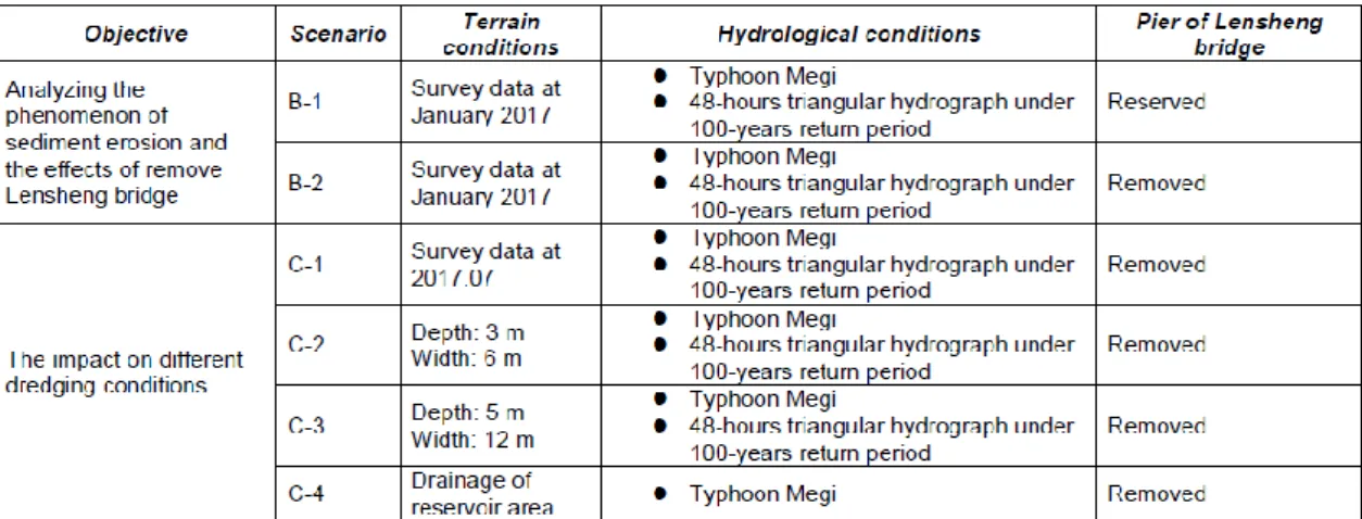
With this 2D model as the main tool , the desilting and drainage problems once be used in Shigang Dam and Hou-Cun Weir assessment and achieve good results. The simulation scenarios are listed as Table 1.
Table 1. Simulation Scenarios
3 Result and discussion
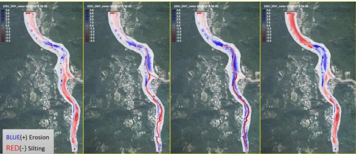
This study evaluated difference dredge plan. Figure 1 shows the performance of different plan under Typhoon Megi. We find out that the original plan C1 is not very effect, sediment will be deposit again when typhoon occur. For plan C2 and C3 they can avoid the deposition after typhoon. As you can see the most area in plan C2 and C3 has been dredged.
Table 2 show some comparison with current situation. We take planB2 as current situation. We can know that, although the main dredging section of planC1 is middle part of the channel, the middle’s sediment is large. It’s mean that, the sediment will deposit again after typhoon. On the other hand, we can find that the sediment deposit in plan C2 and C3 is less than C1, through digging the channel can effectively dredging the sediment and discharge by gate operation.
Besides compare the amount of dredging, we also compare the benefit between each plan. As u can see in the table, there are different reason of depositing, therefore different part of channel needs different dredging plan. For reservoir area, we suggest that discharging sediment by gate operation during the peak flow period will be most useful. And for middle part of channel, we recommend that digging the main channel can dredging
sediment effectively. However, the dredging plan at upstream area has less effect, no matter digging the channel or reservoir area. So maintain the flood capacity, dredging channel regularly will be the best.
Figure 1. The performance of different dredge plan under Typhoon Megi Table 2 The effect of different dredegeplan in upper, middle and reservoir area of Nanshi River
4 Conclusion and Suggestions
In the research, we find that there are different deposit reason in the channel, so we suggest different dredging plan to different part of channel. For upstream area, it’s necessary to dredging regularly for maintain the flood capacity. For middle part, digging the channel will be more effective to discharging sediment. However, landslide and debris flow occur often during typhoon and flood period in Wulai area, because of the topography. We have some suggestion for the area, for short-term, Dredging the channel properly can reduce the level of disaster. Besides, dredging normally with typhoon and flood events the channel can reach a steady state. And for long term, we suggest the government need implement the conservation work to achieve the purpose of sustainable use.
No. Entire area Reservoir area
(Guishian dam~ Wulai Guanguang Bridge)
Middle of channel (Wulai Guanguang Bridge ~Lansheng Bridge)
Upstream of channel (Upstream of Lansheng Bridge)
Silting Erosion Total Silting Erosion Total Silting Erosion Total Silting Erosion Total
B-2 -83110.3 29134.3 -53975.9 -23182.2 7441.3 -15740.9 -23951.3 18701.5 -5249.8 -35976.8 2991.5 -32985.2
C-1 -93535.4 25827.1 -67708.3 -21054.9 7992.5 -13062.5 -40761.6 14166.4 -26595.2 -31718.8 3668.2 -28050.6
C-2 -72191.2 41201.4 -30989.7 -16167.6 10211.6 -5956.0 -27332.2 26614.3 -717.9 -28691.3 4375.5 -24315.8
C-3 -75296.0 62068.4 -13227.6 -12093.1 16637.9 4544.8 -33547.0 36976.3 3429.3 -29656.0 8454.2 -21201.7
Table 3. Suggestion of the Sediment Reduction for Nanshi River
Acknowledgement
The financial support provided for this research by the The 10th River Management Office, Water Resource Agency, Ministry of Economic Affair, Taiwan (MOEAWRA1060422 & MOEAWRA1070242).
References
Greimann, B. (2013). Prediction of sediment erosion after dam removal using a one-dimensional model. Reviews in Engineering Geology, 21, 59-66.
Greimann, B., Lai, Y. (2013). Concurrent Sessions A: Dam Removal II-Simulation of Sediment Transport Upon Dam Removal.
Lai, Y. G. (2008). SRH-2D version 2: Theory and User’s Manual.Sedimentation and River Hydraulics– Two-Dimensional River Flow Modeling, US Department of Interior, Bureau of Reclamation, November.
Lai, Y. G. (2010). “Two-Dimensional Depth-Averaged Flow Modeling with an Unstructured Hybrid Mesh.” J. Hydraulic Engineering, ASCE, 136(1), 12-23.
Lai, Y. G. (2009). Watershed runoff and erosion modeling with a hybrid mesh model. Journal of Hydrologic Engineering, 14(1), 15-26.
Lai, Y. G., Thomas, R. E., Ozeren, Y., Simon, A., Greimann, B. P., Wu, K. (2015). Modeling of multilayer cohesive bank erosion with a coupled bank stability and mobile-bed model. Geomorphology, 243, 116-129.
Authors
Ho-ting Su
Gene J-Y. You (corresponding Author) Yu-Chieh Lin
Sustainable Water Strategy and Technology Research Center, Hydrotech Research Institute, National Taiwan University (NTU), Taiwan
Email: genejyu@ntu.edu.tw
Guishian dam~
Wulai Guanguang Bridge (Dam area)
Wulai Guanguang Bridge ~ Lansheng bridge (Middle area)
Upstream of Lansheng Bridge (Upstream area)
Reason of silting Headward-sediment Downward-sediment Downward-sediment
Benefit of digging the dam area channel
The plan need to operate with peak period.
The river at downward of confluence eroded deeper.
Less effect
Benefit of digging main channel Is influence by the send from
middle area. Need to do with gate operation.
The sediment can discharge to dam area.
Deposit on both sides of floodplain if the flow is high.
Benefit of existing dredging plan
It can maintain by gate operation because the sediment from upward flow less to the dam area.
It deposit easily, therefore the place need to dredge regularly.
It deposit easily, therefore the place need to dredge regularly.