運用多期雷達衛星影像進行大規模崩塌潛勢區 之地表變形量解算
Estimation of Time-Series Surface Deformation in Potential Large Scale Landslide Using SAR Satellite Imagery
主管單位:經濟部中央地質調查所 陳柔妃
Chen, Rou-Fei 中國文化大學地質學系
摘要
本計畫為掌握大規模崩塌潛勢區之活動性與整體變化趨勢,透過時域相關性合 成孔徑雷達干涉技術(Temporarily Coherent Point InSAR,TCPInSAR)進行廣域大規模 崩塌潛勢區之地表長期變形量分析,藉以釐清崩塌區域內潛在活動區塊之時空變形 特徵。自 2014 年 ALOS2 雷達衛星發射以來,本團隊針對水土保持局實施地表位 移觀測及細部現地監測等 43 處大規模崩塌潛勢區,陸續在 106 年及 107 年分別 解算 10 處與 15 處 ALOS2 雷達影像期程之地表長期變形量。延續前期成果,本 計畫在108 年度針對 18 處大規模崩塌潛勢區,進行 ALOS2 地表長期變形量解算 工作,並利用高精度數值地形模型,搭配其他光學影像,輔以地質圖、坡度陰影圖 以及崩塌地形特徵判釋資料等,進行大規模崩塌潛勢區之活動性評估。同時,針對 5 處已架設單頻 GPS 地表位移觀測系統之重點邊坡,利 用 多 時 序 合 成 孔 徑 雷 達 干 涉 技 術 (Multi-Temporal InSAR,MTInSAR),進行時序地表累積變形量分 析,以協助釐清其坡面整體運動模式以及崩塌潛勢區分區分塊之活動機制,提供其 影響範圍、變形速率與變形機制等,有助於後續現地觀測系統之配置等資訊。
本計畫依計畫書之規劃如期完成:(一)新增 4 處大規模崩塌潛勢區自 2007- 2011 年間 ALOS 雷達衛星影像期程之 TCP 長期地表年平均變形量估算;(二)新增 18 處 2014-2017 年間 ALOS2 雷達衛星影像期程之前處理工作與同調性分析;(三) 新增 18 處大規模崩塌潛勢區,2014-2017 年間 ALOS2 雷達衛星影像期程之 TCP 長 期地 表 年平均變 形量 估 算;(四)利用地形幾何關係將衛星入射方向(Line of sight,LOS)地表變形資訊,轉換為沿大規模崩塌坡面方向位移之方法建置;(五)滾動 式檢討全臺 186 處大規模崩塌潛勢區位活動性指標 (LandslideActivity Index,LAI),
使用轉換至之坡面之地表變形速率,重新檢討大規模崩塌潛勢區位活動性指標;(六)
針對 5 處設有單頻 GPS 地表位移觀測站之重點邊坡,完成大規模崩塌潛勢區之時 序地表累積變形量分析,透過雙頻 GPS 連續觀測資料作為外部驗證基準,進行大規
模崩塌潛勢區位地表長期變形量之檢核與精度評估;(七) 完成 5 處重點邊坡
InSAR 與單頻 GPS 觀測資料比對與精度評估。利用雷達衛星影像期程內之地表觀 測變形量,與坡面上單頻 GPS 地表位移觀測位移資訊,進行 5 處重點邊坡不同時 空尺度之地表位移資料比對;(八)結合多時序雷達衛星影像地表變形分析、單頻 GPS 地表位移觀測資料與現地細部調查成果,研擬 5 處重點邊坡之活動特性與潛在崩塌 發育模式,以供未來相關整治規劃之參考。.
關鍵詞:大規模崩塌潛勢區、雷達衛星影像、時域相關點雷達干涉
Abstract
This project has conducted a long-term ground deformation analysis on a wide range of deep-seated landslides using Temporarily Coherent Point InSAR (TCPInSAR) as this technique enables us to clarifythe temporal and spatial deformation characteristics of potential sub-sliding blocks within the sites. Upon the launch of ALOS2 satellite in 2014, our team has, with respect to 43 deep-seated landslide sites under the observation (ground surface displacement) and monitoring (detailed monitoring of selected sites) of Soil and Water Conservation Bureau, successively estimated the long-term deformation of 10 and 15 sites respectively in 2017 and 2018 based on the ALOS2 data. Continuing the results of the previous year, 18 deep-seated landslides are selected in 2019 to estimate their long-term ground deformation based on ALOS2 imagery; and to evaluate their activity using high- precision Digital Elevation Model (DEM) incorporated with aerial photographs, geological map, slope-shade map and interpretation of geomorphological features of landslide.
In the meantime, with respect to five key slopes that have been installed with single- frequency GPS-based displacement observation systems, the Multi-Temporal InSAR (MTInSAR) approach has been adopted to analyze the cumulative ground displacement thereof to clarify the overall slope movement and the sliding structure of deep- seated landslides. This approach not only enables us to understand the scope of impact, deformation rate and failure mechanism of deep-seated landslide, but also facilitates the installation plan for on-site observation and monitoring systems.
Our team has completed this project according to the schedule prescribed in the plan.
The completed works are as follows: (1) Estimate the annual average deformation of 4 newly selected sites between 2007 and 2011 based on their Temporarily Coherent Points (TPCs) generated from the ALOS data. (2) Pre-processing and coherence analysis of ALOS2 satellite imagery collected between 2014 and 2017 with respect to 18 newly selected sites. (3) Estimate the annual average deformation of 18 newly selected sites between 2014 and 2017 based on the TPCs generated from the ALOS2 data. (4) Use the geometric relationship of terrain to convert.
Line-of-Sight (LOS) deformation into slope displacement of deep-seated landslide. (5)
Adopt a rolling review on the Landslide Activity Index (LAI) of 186 deep-seated landslide sites using the data of converted slope displacement rate. (6) Conduct a multi-temporal ground deformation analysis on five deep-seated landslide sites that have been installed with single-frequency GPS-based displacement observation systems. The long-term deformation results and precision thereof are also verified using dual-frequency continuous GPS observation data. (7) Compare the InSAR and single-frequency GPS data of five key slopes; and evaluate the precision thereof. That is, the estimated ground deformation and slope displacement generated from the single-frequency GPS data during the satellite altimetry period are used to compare and verify the ground displacement (of different temporal and spatial scales) of the five key slopes. (8) Specify and propose the activity features and failure mechanism of the five key slopes based on the MTInSAR analysis of satellite imagery, single-frequency GPS displacement and field survey data. The results are expectedly to be used for future disaster mitigation and equipment installation plans.
Keywords:large scale landslides, SAR satellite imagery, TCPInSAR.
一、前言
大規模崩塌可視為深層重力邊坡變形 (deep-seated gravitational slope deformation, DSGSD),其在發生大規模快速運動前,運動型式常為慢速且連續之重力變形或潛變,
進而往往直接或間接造成山坡地房舍、道路及相關設施的災損。目前研判大規模崩塌潛 勢區多採用空載光達判釋地形特徵,輔以野外現勘評估其崩塌機制及潛在危害程度,並 透過各種地表及井下變形觀測系統,進行觀測大規模崩塌之活動特性。唯缺乏區域尺度 之長期地表地形變化,進而系統性分析地表變形特徵,評估大規模崩塌潛勢區之地質概 念模式。
近年來合成孔徑雷達干涉技術 (Interferometric synthetic aperture radar, InSAR)廣泛地應 用於自然災害相關領域,其全天候、高解析度和連續空間覆蓋的優勢,可快速產製大範 圍地表變形資料。行政院農業委員會水土保持局(以下稱水土保持局)自104年度即投入大 規 模 崩 塌 潛 勢 區 地 表 地 形 特 徵 與 活 動 性 觀 測 技 術 研 發 , 使 用 日 本 雷 達 衛 星 影 像 (ALOS/ALOS2),配合時域相關點雷達干涉技術(Temporarily Coherent Point InSAR, TCP- InSAR)。透過SAR雷達衛星觀測大面積地表變形,將其優勢應用在防災科技與智慧坡地 觀測之實務工作。目前世界各國皆紛紛投入研究、發射雷達衛星,全面性地覆蓋地球表 面,結合不同雷達衛星種類時,將提高雷達影像之時間解析力,進而有助於達到廣域性 大規模崩塌潛勢區之活動性觀測。
二、工作方法及流程
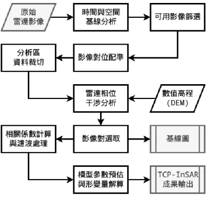
2.1 研究流程
本計畫使用TCPInSAR技術進行地表長期平均變形量解算,建置不同時間衛星雷達
影像中各點之時域相關指標(temporal coherence),經由解算視窗之移動與匹配,得到各 點在不同時間序列之位移總量。操作流程如(圖1):
2.1.1 時空基線計算與影像對篩選
選定包含欲觀測地區的雷達影像圖幅。由於衛星是週期性運行,同一地區會有在 不同時間點拍攝的多幅影像。利用個別影像攝製時的相關參數,計算所有影像對的時 空基線(temporal and spacial baseline),對於時間基線或空間基線不符合門檻值的影像對 予以移除,不參與之後的處理。
2.1.2 雷達影像對位配準
實務上影像配準時會將初步篩選後的影像對中出現最多次之影像選為主影像並將 所有其他影像作為副影像與其配準。
2.1.3 大規模崩塌潛勢區範圍截取
針對今年度新增18處大規模崩塌潛勢區,進行雷達衛星原始影像截切,將待分析資 料空間範圍縮減至目標位置附近的區域,可以提高資料分析效率並減少干涉相位解纏時 可能發生的誤差。
2.1.4 差分雷達干涉圖產製
干涉圖對應之相位即是兩幅SAR影像之相位差,配準後的主副影像經過共軛相乘可 得雷達干涉圖。
2.1.5 影像同調性評估
影像間的同調性(coherence)值介於0至1,表示兩張影像中地形與地物的相似程度,
它反映了干涉圖中相位訊噪比的大小。
2.1.6 干涉相位過濾
由於基線長度和系統本身性能的影響,干涉相位圖不可避免地引入許多相位雜訊。
雜訊的存在會降低干涉圖的品質,使得後續TCP-InSAR的處理困難並引致更多的解算誤 差,而適當的過濾能有效降低相位雜訊,提高干涉圖的品質。
2.1.7 時域相關點選定
MT-InSAR分析第一步通常是時域相關點(Temporarily Coherent Point, TCP)的選定,
其相關性的優劣及點位的分佈密度會直接影響最終解算結果。
2.1.8 建立區域三角網與解算變形參數
TCP-InSAR技術採用區域型Delaunnay三角網進行相位與變形量的解算。
圖 1 TCP-InSAR 演算法流程圖
2.2 使用日本 JAXA-ALOS/ALOS2 衛星雷達影像資料
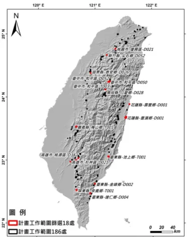
本計畫使用2007-2011 年 ALOS 雷達衛星影像,進行廣域大規模崩塌潛勢區之長
期地表平均變形量解算工作。由於ALOS 雷達衛星飛行週期為 46 天,而雷達衛星影像
拍攝軌道的位置不同,因此臺灣地區軌道有447、446、445、444 及 443。如圖 2 所 示。
ALOS2雷達衛星,為延續2011年5月12日退役的L波段ALOS合成孔徑雷達衛星,該衛 星於 2014年5 月24日發射,目標為提供製圖、區域觀測、災害監測和環境的連續性監 測數據資料。根據ALOS-2雷達衛星影像條帶分布,本計畫選定此18處特定邊坡均落於條 帶137-450升軌影像ASC-F2、ASC-F3、ASC-F4間。在進行廣域大規模崩塌潛勢區之地表平 均變形速率解算時,本計畫中18處特定邊坡皆各別截切成更小圖幅進行TCPInSAR之解算 (圖2)。
圖 2 本計畫使用 ALOS 之影像分布圖(左) 與 15 處特定邊坡分布圖(右) 2.3 TCP-InSAR 時域相關點雷達干涉技術
Zhang 等人(2011)提出 TCPInSAR 技術,利用時域相關點(Temporarily Coherent Point, TCP)的相位差向量進行最小二乘法解算,通過殘差的大小來區別有模糊度和沒有
模糊度的TCP 點,取代容易產生錯誤或失敗的相位回復步驟,進一步來計算地表變形
率。為降低大氣延遲的隨機模式誤差,Zhang 等人(2012)利用多幅干涉影像堆疊平均來
降低大氣延遲的隨機模式誤差,利用穩定TCP 點將大氣效應造成的相位差從殘餘相位
中分離出來,進而抑制其誤差。軌道誤差藉由物理模型與地面控制點來推估軌道相位 圖譜(orbital ramp)進行修正,透過誤差參數在相位解算的過程中,估算軌道誤差的影 響。
三、工作成果
3.1 雷達衛星影像前處理
OS/ALOS2衛星雷達影像進行合成孔徑雷達技術之前處理工作,包括衛星原始影像 格式轉換、時空基線評估、雷達影像優選及大氣、軌道與地形效應等修正。本計畫使 用前期計畫所發展之同調性指標,利用相應模組將雷達衛星影像的狀態參數、殘餘軌 道相位等,針對空間基線產製精確誤差估計,並進行衛星雷達影像定位校正及干涉相 位濾波等同調性分析工作。其影像同調性之分析方法為:干涉像對空間基線的精確估 計、雷達影像定位校正、干涉相位濾波。本計畫利用主、副影像之間的影像同調性作 為選取干涉圖的依據(Ferretti et al., 2000, Mora et al., 2003)
圖3 各種誤差來源干涉條帶圖 (a)軌道誤差; (b)大氣誤差; (c)地形誤差 3.2 大規模崩塌潛勢區之地表平均變形量估算
3.2.1 解算 ALOS 影像期程內 4 處大規模崩塌潛勢區之地表平均變形量
本年度4處大規模崩塌潛勢區分別位於3張ALOS雷達衛星圖幅,依前項TCPInSAR 地表變形解算方法與流程,建置2007-2011雷達衛星期程內之時空基線及影像干涉 圖。各圖幅之解算成果點密度均達200點/平方公里以上。本計畫以ALOS影像期程內 (2007-2011年)地表平均變形成果,利用空載光達數值地形模型(1m解析度)搭配福衛二 號影像,輔以地質圖、坡度陰影圖及崩塌地形特徵判釋資料等,針對4處大規模崩塌 潛勢區進行地表平均變形量分析。
3.2.2 解算 ALOS2 影像期程內 18 處大規模崩塌潛勢區之地表平均變形量
本年度18處大規模崩塌潛勢區(圖4)依前項TCPInSAR地表變形解算方法與流程,
建置2014-2018雷達衛星期程內之時空基線及影像干涉圖,本計畫所產製各圖幅之地 表平均變形量,其解算成果點密度均達200點/平方公里以上。
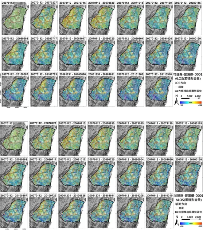
以花蓮縣-豐濱鄉-D001 為例(表 1、圖 5),崩塌地坐落於花蓮縣豐濱鄉磯崎村,該 崩塌潛勢區海拔高約322 公尺,面積約 464.5 公頃。該區出露地層為都鑾山層與八里灣 層泰源段,岩性主要為火山角礫岩與砂頁岩互層。光達數值地形判釋所得之崩塌潛勢 區長約2524 公尺、寬為 1901 公尺、高差達 738 公尺,平均坡度 19.6 度,坡向朝東,
為高度順向坡地形。崩塌潛勢區內ALOS2 影像分析所得之 TCP 資料顯示可代表活動
性之TCP 點數有 1364 個、下降點平均速率之累積值為-8639 mm/yr,活動性平均速率 為-6.3 mm/yr。在資料轉換至沿坡面之運動,下降點平均速率之累積值為 -14268 mm/yr,活動性平均速率為 -11.2 mm/yr。
圖 4 本計畫工作範圍篩選 18 處重點邊坡分布圖 表 1 花蓮縣-豐濱鄉-D001 崩塌地特性介紹
崩塌地區域地形地質資訊 崩塌地活動性
行政位置 花蓮縣豐濱鄉磯崎村 ALOS (2007-2011) LOS向 坡向 坐標 (304825 , 2620208) 活動點數(個) 715 684
面積(公頃) 464.5 活動總量(公厘) -1794 -3337
坡度(度) 19.6 平均速率(mm/yr) -2.5 -4.9
坡向 東(113±60) ALOS2 (2014-2018) LOS向 坡向
海拔(公尺) 322 活動點數(個) 1364 1279
崩塌長(公尺) 2524 活動總量(公厘) -8639 -14268
崩塌寬(公尺) 1901 平均速率(mm/yr) -6.3 -11.2
崩塌高差(公尺) 738 崩塌發生潛勢
順向坡 高度順向坡 發生度 低
地質年代 中新世、上新世--更新世早期、
全新世 重要保全 高
地層分佈 都鑾山層、八里灣層泰源段、沖
積層 活動度 中
地質條件 火山角礫岩與沉積岩
圖 5 花蓮縣-豐濱鄉-D001 崩塌地表地形資訊及活動性分布圖 3.3 重點邊坡累積地表變形量估算與精度檢核
5處重點邊坡分別為:南投縣-仁愛鄉-D028、臺中市-和平區-D045、臺東縣-達仁 鄉-D004、花蓮縣-豐濱鄉-D001及苗栗縣-泰安鄉-D026。將依據針對2007-2011年間 ALOS及2015-2018年間ALOS2雷達衛星影像期程,分述5處重點邊坡之時間序列地表 變形分析,亦針對此5處進行野外現地調查。
圖 6 花蓮縣-豐濱鄉-D001 崩塌時間序列累積形變量分布 3.4 大規模崩塌潛勢區之地表觀測成果及活動性評估
本團隊於105年度執行『運用雷達影像進行莫拉克颱風災區大規模崩塌潛勢區位 之可行性評估』委辦計畫時,提出大規模崩塌潛勢區位之活動性指標(Landslide Active Index),利用TCPInSAR所計算出之地表變形資訊,提出二種評估大規模崩塌活動性的 方法,分別為單位面積之平均下降值代表及整體下降總量。其計算方法為在單一崩塌 潛勢區位內,所有下降之數值即為下降總量,有別於僅考慮單一平均下降數值,能夠 摒除單位面積TCP點數過少的問題;而單位面積之平均下降值即是用TCP下降點個數
數之下降總量,每一TCP點之空間解析度為30公尺,可視為有效面積之平均下降程 度。
本計畫彙整全台186 大規模崩塌潛勢區之基礎資料,例如坡度、坡向及保全戶數
等, 在進行全台 186 大規模崩塌潛勢區位活動性排序時,依據活動性指標一及二之活 動性排序結果,分為三個級別,以高、中、低來區別。以活動度風險矩陣的概念(圖 15),將指標一及二皆為活動性高者,即為”高活動性”之大規模崩塌潛勢區,經整合 排序之後全台186 處中計有 60 處,佔 33%。其次,將指標一及二皆為活動性低者,即
為”低活動性”之大規模崩塌潛勢區,經整合排序之後全台186 處中計有 43 處,佔
24%,最後,其餘大規模崩塌潛勢區位則劃分在”中活動性”之大規模崩塌潛勢區位 共計77 處佔 43%。
四、結論與建議
本計畫於今年度完成ALOS/ALOS2衛星雷達影像資料前處理及同調性分析、廣域 大規模崩塌之地表平均變形量計算(4處ALOS影像期程及18處ALOS2影像期程內之地表 平均變形量)、多時期雷達衛星影像地表變形量、單頻GPS地表位移觀測資料比對與精 度評估、研擬衛星觀測方向轉換為坡面方向位移之方法論及用以滾動檢討186處大規模 崩塌潛勢區位活動性指標。在五處重點邊坡之MT-InSAR解算中,其與單頻GPS觀測資 料及雨量的比對顯示良好之時序正相關性。反應MT-InSAR解算資料除可顯示潛在大規 模崩塌區域長時間地表變形之變化外,當時間基線夠短時亦可反應較大規模雨量事件 所造成的影響。
根據數值地形坡向分析結果,考量ALOS 衛星觀測幾何變形誤差,顯示全臺 186
處大規模崩塌潛勢區位,超過半數以上的崩塌坡向(東北/東南)符合衛星雷達觀測佔 57.2%,至於其它 42.2%的崩塌坡向(西北/西南),雖然資料數量較少,但透過 LOS 向之 位移轉換至坡面方向之位移,仍可進行崩塌潛勢區之活動性評估與分區分塊研究。在
地形坡度分析結果,坡度大於42 度的崩塌區會受到地形影響而不利觀測,186 處大規
模崩塌坡度大於40 度僅佔 2 處,在幾何觀測的誤差中,因地形遮蔽所造成陰影效應,
則必須使用另外多個觀測方向的衛星資料來彌補。
為了精確研判山崩之滑動規模與滑動機制,過去多採用各種地表觀測或孔內觀測 儀器,可得到即時且高精度的山崩活動觀測資料,對了解山崩的機制與研擬山崩預警 策略而言是一大助力。然而,地質鑽探與觀測儀器設置皆所費不貲,再者其觀測資料 受限於單點觀測,以此推估整個潛在山崩區域的滑動面位置與滑動機制仍有一定的難 度。透過 InSAR 資料之解算與分析,能夠區域性掌握長期地表變形的空間變化特性,
建議可以透過地表位移反演之模式協助釐清潛在滑動面之位置,並協助滑動機制之瞭 解。
參考文獻
1. 陳富龍、林珲、程世來(2014)。星載雷達干涉測量及時間序列分析的原理、方法與 應用,北京:科學出版社
2. 林慶偉、李心平(2016)。105 年非莫拉克災區潛在大規模崩塌地區危險度評估與簡 易觀測系統建置,農委會水土保持局。
3. 王超(1997)利用太空梭成象雷達干涉資料提取數位高程模型。遙感學報。P46-49。
4. 廖明生、林琿、張祖勳(2003)INSAR 干涉條紋圖的複數空間自我調整濾波。遙感學 報。2003/6 (1)。
5. 劉國祥(2004)SAR 成像原理與圖像特征,四川測繪。2004(03)。
6. Lillesand, T.M., Kiefer, R.W. and Chipman, J.W. (2008) Remote Sensing and Image Interpretation. 6th Edition, John Wiley & Sons, Hoboken.
7. Zhang, L. (2012) Temporarilycoherent point SAR interferometry, Dept. of Land Surveying & Geo-Informatics, The Hong Kong Polytechnic University, Ph.D Thesis.
8. Stevens, J. P. (1990). Intermediate statistics: A modern approach. Hillsdale, NJ, US:
Lawrence Erlbaum Associates, Inc.
9. Agliardi, F., Crosta, G., & Zanchi, A. (2001). Structural constraints on deep-seated slope deformation kinematics. Engineering Geology, 59(1-2), 83-102.
10. Bateson, L., Cigna, F., Boon, D. and Sowter, A., (2015). The application of the Intermittent SBAS(ISBAS) InSAR method to the South Wales Coalfield, UK.
International Journal of Applied Earth Observation and Geoinformation, Vol.34, 249-257.
11. Berardino, P., Fornaro, G., Lanari, R. and Sansosti, E., (2002). A new algorithm for surface deformation monitoring based on small baseline differential SAR interferograms.
IEEE Transactions on Geoscience and Remote Sensing, Vol.40 (11), 2375-2383.
12. Cascini, L., Fornaro, G. and Peduto, D., (2010). Advanced low- and full-resolution DInSAR map generation for slow-moving landslide analysis at different scales.
Engineering Geology, Vol.112, 29-42.
13. Chang, C. P., Chen, K. S., Wang, C. T., Yen, J. Y., Chang, T. Y., & Lin, C. W. (2004).
Application of space-borne radar interferometry on crustal deformations in Taiwan: A perspective from the nature of events. Terrestrial, Atmospheric and Oceanic Sciences, 15(3), 523-543.
14. Chigira, M. Tsou, C. Y. and Matsushi., (2013). Topographic precursors and geological structures of deep-seated catastrophic landslides caused by Typhoon Talas.
Geomorphology. Vol. 201, 479-493.
15. Charles-Alban Deledall, Loïc Denis, Florence Tupin (2011). NL-InSAR: Non-Local Interferogram Estimation. IEEE Transactions on Geoscience and Remote Sensing , Volume: 49, Issue: 4
16. Covello, F., Battazza, F., Coletta, A., Lopinto, E., Fiorentino, C., Pietranera, L., Zoffoli, S.
(2010). COSMO-SkyMed an existing opportunity for observing the Earth. Journal of Geodynamics, 49(3-4), 171-180.
17. Colesanti, C. and Wasowski, J., (2006). Investigating landslides with space-borne Synthetic Aperture Radar (SAR) interferometry. Engineering Geology, Vol.88(3-4), 173- 199.
18. Champenois, J., Fruneau, B., Pathier, E., Deffontaines, B., Lin, K.-C. and Hu,J.-C., (2012). Monitoring of active tectonic deformations in the Longitudinal Valley (Eastern Taiwan) using Persistent Scatterer InSAR method with ALOS PALSAR data. Earth and Planetary Science Letters, Vol.337-338, 144-155.
19. Ding, X. L., Li, Z. W., Zhu, J. J., Feng, G. C., & Long, J. P. (2008). Atmospheric effects on InSAR measurements and their mitigation. Sensors, 8(9), 5426-5448.
20. Ding, C., Feng, G., Li, Z., Shan, X., Du, Y., & Wang, H. (2016). Spatio-temporal error sources analysis and accuracy improvement in landsat 8 image ground displacement measurements. Remote Sensing, 8(11), 937.
21. Eastman C., Teicholz P.,Sacks R. and Liston K. (2008)BIM Handbook: A Guide to Building Information Modeling for Owners. Managers, Designers, Engineers and Contractors, Wiley, 504 Pages.
22. Eeckhaut, M., V., D., Kerle, N., Poesen, J. and Hervás, J., (2012). Object-oriented identification of forested landslides with derivatives of single pulse LiDAR data.
Geomorphology, Vol.173-174, 30-42.
23. El-Baz, Farouk & Robinson, C.A. & S.M. Al-Saud, Turki. (2007). Radar Images and Geoarchaeology of the Eastern Sahara. Remote Sensing in Archaeology. 47-69.
10.1007/0-387-44455-6_2.
24. Elias, P., Kontoes, C., Papoutsis, I., Kotsis, I., Marinou, A.,Paradissis, D. and Sakellariou, D., (2009). Permanent ScattererInSAR Analysis and Validation in the Gulf of Corinth.
Sensors,Vol.9(1), 46-55.
25. Fattahi, H., & Amelung, F. (2013). DEM error correction in InSAR time series. IEEE Transactions on Geoscience and Remote Sensing, 51(7), 4249-4259.
26. Farr,T. G., et al. (2007),The Shuttle Radar Topography Mission, Rev. Geophys., 45, RG2004, doi:10.1029/2005RG000183.
27. Ferretti, A., Prati, C., & Rocca, F. (2001). Permanent scatterers in SAR interferometry.
IEEE Transactions on geoscience and remote sensing, 39(1), 8-20
28. Ferretti A., Parizzi A., Perissin D., Prati C., Rocca F. (2006)Accurate DEM reconstruction from Permanent Scatterers and multi-baseline interferometry. Proceedings of the IEEE International Geoscience and Remote Sensing Symposium - IGARSS, Denver (Colorado).
29. Ferretti, A., C. Prati, and F. Rocca (2000)Nonlinear subsidence rate estimation using permanent scatterers in differential SAR interferometry. Geoscience and Remote Sensing 38: 5, 2202-2212.
30. Fruneau, B., Pathier, E., Raymond, D., Deffontaines, B., Lee, C. T., Wang, H. T., Chang, C. P. (2001). Uplift of Tainan Tableland (SW Taiwan) revealed by SAR interferometry.
Geophysical Research Letters, 28(16), 3071-3074.
31. Graham, L.C., (1974). Synthetic Interferometer Radar for Topographic Mapping, Proceedings of the IEEE, vol.62, no.6, pp.763.
32. Hanssen, R. F., (2001). Radar Interferometry: Data Interpretation and Error Analysis.
Kluwer Academic Publishers. Dordrecht, 308 p.
33. Hooper, A., H. Zebker, P. Segall, and B. Kampes (2004), A new method for measuring deformation on volcanoes and other natural terrains using InSAR persistent scatterers, Geophys. Res. Lett., 31, L23611.
34. Hooper, A., Segall, P., & Zebker, H. (2007). Persistent scatterer interferometric synthetic aperture radar for crustal deformation analysis, with application to Volcán Alcedo, Galápagos. Journal of Geophysical Research: Solid Earth, 112(B7). 32
35. Hooper, D., Coughlan, J., & Mullen, M. R. (2008). Structural Equation Modelling:
Guidelines for Determining Model Fit. The Electronic Journal of Business Research Methods, 6, 53-60.
36. Jia, P. Z. and Tao, Z. Z. (1984). Optimal Estimation and its Applications, Science Press, Beijing, China.
37. Kojima, S., Nagata, H., Yamashiroya, S., Iwamoto, N. and Ohtani, T., (2015). Large deep- seated landslides controlled by geologic structures: Prehistoric and modern examples in a Jurassic subduction–accretion complex on the Kii Peninsula, central Japan. Engineering Geology, Vol.186(24), 44-56.
38. Lin, C.W.; Tseng, C.M.; Tseng, Y.H.; Fei, L.Y.; Hsieh, Y.C.; Tarolli, P. (2013)Recognition of large scale deep-seated landslides in forest areas of Taiwan using high resolution topography. J. Asian. Earth Sci., 62, 389-400.
39. Liang H., Zhang L., Ding X., Lu Z. andLi X., (2018)Toward Mitigating Stratified Tropospheric Delays in Multitemporal InSAR: A Quadtree Aided Joint Model, IEEE Transactions on Geoscience and Remote Sensing , page 1-13doi:
10.1109/TGRS.2018.2853706
40. Massonnet, D., Rossi, M., Carmona, C., Adragna, F., Peltzer, G., Feigl, K., and Rabaute, T., (1993) The displacement field of the Landers earthquake mapped by radar
interferometry. Nature, vol.364, pp138-142.
41. McCAULEY, J. F. and SCHABER, G. G. and BREED, C. S. and GROLIER, M. J. and HAYNES, C. V. and ISSAWI, B. and ELACHI, C. and BLOM, R. (1983). Subsurface Valleys and Geoarcheology of the Eastern Sahara Revealed by Shuttle Radar. Science (New York, N.Y.). 218. 1004-20. 10.1126/science.218.4576.1004.
42. Mora, O., Mallorqui, J. J., & Broquetas, A., (2003). Linear and nonlinear terrain
deformation maps from a reduced set of interferometric SAR images. IEEE Transactions on Geoscience and Remote Sensing, 41, 2243-2253
43. Pathier, E., Fruneau, B., Deffontaines, B., Angelier, J., Chang, C. P., Yu, S. B., & Lee, C.
T. (2003). Coseismic displacements of the footwall of the Chelungpu fault caused by the 1999, Taiwan, Chi-Chi earthquake from InSAR and GPS data. Earth and Planetary Science Letters, 212(1-2), 73-88.
44. Peltier, A., Staudacher, T. and Bachèlery, P., (2010). New behaviour of the Pitonde La Fournaise volcano feeding system (La Réunion Island) deduced from GPSdata: Influence of the 2007 Dolomieu caldera collapse. Journal of Volcanologyand Geothermal Research, Vol.192, 48-56.
45. Rogers, A.E., and Ingalls, R.P., (1969), Venus: mapping the surface reflectivity by radar interferometry, Science 165(3895), 797–799.
46. Shiffler, R. E. (1988). Maximum Z score and outliers. The American Statistician,42(1), 79-80.
47. Sergey Samsonov, Magdalena Czarnogorska, Don White, (2015) Satellite interferometry for high-precision detection of ground deformation at a carbon dioxide storage site, International Journal of Greenhouse Gas Control, Vol. 42, 188-199.
48. Du, Y., Zhang, L., Feng, G., Lu, Z., & Sun, Q. (2017). On the Accuracy of Topographic Residuals Retrieved by MTInSAR. IEEE Transactions on Geoscience and Remote Sensing, 55, 1053-1065.
49. Zhang, L., Ding, X., & Lu, Z. (2011). Ground settlement monitoring based on temporarily coherent points between two SAR acquisitions. ISPRS Journal of Photogrammetry and Remote Sensing, 66(1), 146-152
50. Zhang, L., Lu, Z., Ding, X., Jung, H.-S., Feng, G. and Lee, C.-W., (2012). Mapping ground surface deformation using temporarily coherent point SAR interferometry:
Application to Los Angeles Basin. Remote Sensing of Environment, Vol.117, 429-439.
51. Zhang, L., Ding, X., Lu, Z., Jung, H. S., Hu, J., & Feng, G. (2014). A novel multitemporal InSAR model for joint estimation of deformation rates and orbital errors. IEEE
Transactions on Geoscience and Remote Sensing, 52(6), 3529-3540。
52. Chen, C-H. and Lin, S.B. (2002) Eruptions younger than 20Ka of the Tatun Volcano Group as viewed from the sediments of the Sungshan Formation in Taipei Basin. Western Pacific Earth Sciences, 2, 191-204.