龜咯水上聚落適應海岸環境之空間模式發展研究
138
0
0
全文
(2) i.
(3) 龜咯水上聚落適應海岸環境之空間模式發展研究 國立成功大學都市計劃碩士論文 2014 年 1 月 研 究 生:賴佳燕 指導教授:曾憲嫻. 摘要 氣候變遷與海平面上升所帶來的潛在災害,使“與水共生"的議題日益受到 都市研究領域的重視。沿海聚落必須因應氣候與其他物理或社經因素的變遷進行調 適,以便盡可能降低破壞與發掘未來發展的機會。 對於應用在地的資源與方式促成有機生長的傳統聚落,瞭解當地居民的居住 感受與執行調適政策的能力極為重要。然而,這方面的措施卻時常受到忽略,以致 政策最終導向失敗。為了了解當地居民觀點與空間模式發展之間的相互關係,本研 究將探討當地草根為因應海岸環境所做之調適措施,如何反映在空間模式的發展上。 水上聚落為馬來西亞一種傳統的生活方式。部分肇因於其在法律上定義為非 法建築,針對水上聚落的空間與(或)環境調適上的相關研究極少。然而,這類聚落 因其地理位置的關係,實際上為海平面上升(Md. Din & Mohd. Omar, 2009)及其他海 岸潛在災害(Chan, 1995)的相對高風險暴露族群。 以馬來西亞柔佛州龜咯水上漁村(港腳漁村及鹹水港漁村)為例,本研究通 過詳細的田野調查與訪問,探討生活在沿海環境的在地居住觀感點如何形塑聚落的 空間模式。通過研究設計的兩個時期進行觀察,研究結果將呈現社區尺度與建築尺 度的空間發展與其變遷原因。本研究發現,水上聚落的空間模式發生改變與空間調 整,主要為因應環境的改變。長期的居住經驗形塑了居住觀點,而空間模式的發展 則反映了居民與水共生的經驗。瞭解在地居住觀點對於落實任何的災害調適措施極 為重要。本研究為補充傳統水上聚落研究之匱乏,對其空間模式進行詳盡的調查與 分析,以提供未來相似自然與人文條件之水上聚落空間發展與調適策略之相關研究 參考。 關鍵字:空間模式,水上聚落,在地觀點,海岸環境,龜咯 ii.
(4) Spatial pattern development of Kukup water settlement in adapting coastal environment Author: Jia-Yen Lai Advisor: Hsien-Hsin Cheng Submitted in partial fulfillment of the requirements for the degree of Master of Urban Planning at National Cheng-Kung University, Tainan, Taiwan. Abstract The concern of “living with water” raises increasing attention due to potential disasters following by climate change and sea level rise. It is recognized that coastal community needs to adapt in order to moderate the harm or exploit beneficial opportunities resulting from changes in climate and other physical or socio-economic factors. For organic-growth traditional settlement that was built by local resources and measure, it is important to consider people’s perception and capacity to implement adaptation policy. However, it is usually be neglected and leads to failure of policy. To identify the interrelation between local perception and spatial pattern, this study discusses how grassroots’ response to coastal environment reflects on spatial pattern development. Water settlement is one of the traditional lifestyles in Malaysia. Partly due to illegal position in land use, the study of its space or/and adaptation to environment have received less attention and are limited in literature. And yet, these settlements are actually considered comparative high-risk exposed to sea level rise (Md. Din & Mohd. Omar, 2009) or other coastal potential disasters (Chan, 1995) based on their location. Using case study of Kukup water settlement (Kukup Laut Fishing Village and Ayer Masin Fishing Village) in Johor State, Malaysia, this study conducts field research and interviews to identify local perception to coastal environment in shaping settlement’s pattern. Applying to two designed phases, the result shows spatial pattern at community scale and building scale in order to identify the development and the causes. The study finds that spatial pattern has been facilitated to adapt to coastal environment. The everyday life experience, therefore, formed local perception; and the pattern represents the generation’s experience to live with water. To understanding local perception to coastal environment and its changes is essential to practice of any adaptation policy. Through a detailed investigation and analysis to spatial pattern, it is to provide appropriate reference for further spatial and/or adaptation studies of traditional water centric community with similar natural and man-made conditions. Keyword: spatial pattern, water settlement, local perception, coastal environment, Kukup. iii.
(5) 誌謝 感謝指導老師曾憲嫻副教授給與我無價的支持。感謝您對我的研究給與巨大 的鼓勵與平等的發揮空間,讓我能夠堅持自己的興趣與想像。感謝口試委員孔憲法 教授、陳啟仁副教授、吳秉聲副教授,在百忙之中撥冗給予學生珍貴的建議與斧正。 感謝在我的研究基地-龜咯漁村-的受訪村民們,尤其是洪祖秋校長、陳樹藩村長、 洪永順副村長、戴龍儒先生及柯賢敏先生。感謝所有受訪村民給與熱情無償的支持 與協助。感謝許多朋友,尤其是曉慧、一秀、慧珠、佩愛、雅婷、偉杰以及研究所的 同學們,因為大家的幫忙與鼓勵,支持我完成研究。 特別感謝我的母親與已故的父親。文字無法表達我對你們的感激。我將此論 文獻給你們。你們的寬容與信任至今仍支撐著我前進。. iv.
(6) Acknowledgement I would like to express my special appreciation and thanks to my advisor Associate Professor Dr. Hsien-Hsin Cheng, your support has been priceless. I would like to thank you for encouraging my research and for offering me equal opportunity to work with my passion and imagination. I would also like to thank my committee members, Professor Shiann-Far Kung, Associate Professor Chi-Jen Chen, and Associate Professor Ping-Sheng Wu for serving as my committee members even at hardship. I also want to thank you for letting my defense be an enjoyable moment, and for your brilliant comments and suggestions, thanks to you. I would especially like to thank all the generous interviewees in the study site at Kukup, especially Mr. Chor Chew Ang, P.P.N. William Tan, Mr. YongShun Hong, Mr. Long-Ru, Tai, and Mr. Xian Min Ke. All of you have been there to support me when I collected data for my thesis. I would like to thank my friends and peers especially Hsiao-Hui, Yisiu, Huechu, Peiai, Yating, and Weijie who supported me in writing, and incented me to strive towards my goal. A special thanks to my parents. Words cannot express how grateful I am to my mother and my late farther for all of that you’ve made on my behalf. I dedicate this thesis to you. Your tolerance and trust for me were what sustained me thus far.. v.
(7) Table of Contents List of Tables ......................................................................................................................... II List of Figures ...................................................................................................................... III Chapter 1 Introduction ........................................................................................................... 1 1.1 . Research Motive and Objective ............................................................................... 1 . 1.2 . Research Contents ................................................................................................... 2 . 1.3 . Research Scope ........................................................................................................ 3 . 1.4 . Literature Review .................................................................................................... 8 . 1.5 . Research Design .................................................................................................... 37 . 1.6 . Research Process ................................................................................................... 42 . Chapter 2 Spatial Pattern at Community Scale .................................................................... 43 2.1 Introduction to Kukup water settlement ..................................................................... 43 2.2 The development of spatial pattern ............................................................................ 49 2.3 The characteristic of spatial pattern ........................................................................... 55 2.4 Community’s response to coastal environment ......................................................... 73 Chapter 3 Spatial Pattern at Building Scale ......................................................................... 77 3.1 Overall pattern of building ......................................................................................... 77 3.2 Internal layout and pattern development .................................................................... 78 3.3 The construction method and material ....................................................................... 80 3.4 Comparison with traditional Malay architecture ........................................................ 95 3.5 Building response to coastal environment ................................................................. 97 3.6 Conclusion .................................................................................................................. 98 Chapter 4 Conclusion and Suggestion ................................................................................. 99 4.1 Conclusion .................................................................................................................. 99 4.2 Suggestion ................................................................................................................ 103 Reference ............................................................................................................................ 104 Glossary .............................................................................................................................. 106 Appendix ............................................................................................................................ 107 . I.
(8) List of Tables Table 1.1 Summary to Kukup Laut and Ayer Masin Fishing Village’s Development ......... 6 Table 1.2 Basic components of traditional Malay house .................................................... 26 Table 1.3 Sea Level Rise of Malaysia at Tide Gauges........................................................ 33 Table 1.4 Observed and projected climate change in Malaysia .......................................... 34 Table 1.5 Summary of Literature Review ........................................................................... 35 Table 2.1 Additional sequence of development .................................................................. 69 Table 2.2 Spatial pattern adjustment in adapting coastal environment ............................... 73 Table 3.1 Construction process of wooden house ............................................................... 81 Table 3.2 Construction process of concrete house .............................................................. 88 Table 3.3 Construction process of Kelong .......................................................................... 92 Table 3.4 Construction process of floating fish farm .......................................................... 93 Table 3.5 Comparison of water building and Malay building ............................................ 96 . II.
(9) List of Figures Figure 1.1 Pontian District and Location of Study Area ....................................................... 4 Figure 1.2 Photos of Kukup water villages ........................................................................... 5 Figure 1.3 Diagram of spatial development's literature review ............................................ 9 Figure 1.4 Diagram of spatial form and pattern .................................................................. 13 Figure 1.5 Shaping process of water settlement's spatial pattern ........................................ 14 Figure 1.6 Flexible interfaces of streets in traditional settlement ....................................... 15 Figure 1.7 The social production of public space ............................................................... 16 Figure 1.8 Port City during Johor Sultanate Kingdom in 16th Century ............................. 18 Figure 1.9 Patterns of water village .................................................................................... 19 Figure 1.10 Spatial development layout of Hong Kong Tai-O water village ..................... 20 Figure 1.11 Diagrams of spread, wooden-pile, friction-pile, and floating foundation ....... 22 Figure 1.12 External environment of the Malay house ....................................................... 24 Figure 1.13 ‘A Malaye Village’, drawn and engraved by T. & W. Daniell, 1810.............. 24 Figure 1.14 Type of Malay house and the distribution in Peninsular Malaysia.................. 25 Figure 1.15 Diagram of basic components of traditional Malay house .............................. 26 Figure 1.16 Basic construction methods and additional sequence of Malay house ............ 27 Figure 1.17 Layer model combines spatial scale with vertical differentiation in temporal dynamics.............................................................................................................................. 31 Figure 1.18 Monthly mean sea levels for tide gauge stations in West Coast PM ............... 33 Figure 1.19 Diagram of Research Design ........................................................................... 41 Figure 1.20 Research Process.............................................................................................. 42 Figure 2.1 Protected area system in Peninsular Malaysia ................................................... 44 Figure 2.2 Terrain of Pontian district .................................................................................. 44 Figure 2.3 Terrain of Kukup water settlement .................................................................... 45 Figure 2.4 Land use of Pontian and location of case study ................................................. 45 Figure 2.5 Kukup settlements in 1940s ............................................................................... 48 Figure 2.6 Layout of Kukup Laut fishing village before 1970 ........................................... 49 Figure 2.7 Paranomic image of Kukup Laut fishing village in 1970 .................................. 50 Figure 2.8 Layout of Ayer Masin fishing village before 1970............................................ 50 Figure 2.9 Houses built along riverbank ............................................................................. 51 Figure 2.10 Layout of Kukup Laut fishing village after 1970 ............................................ 51 III.
(10) Figure 2.11 Layout of Ayer Masin fishing village after 1970 ............................................ 52 Figure 2.12 Kelong and floating fish farm .......................................................................... 53 Figure 2.13 Distribution of Kukup settlement in two phases .............................................. 54 Figure 2.14 Resort and mix-use of house ............................................................................ 55 Figure 2.15 Earliest layer of Kukup Laut and Ayer Masin remained similar function....... 56 Figure 2.16 Land use before 1970 ....................................................................................... 57 Figure 2.17 Land use after 1970.......................................................................................... 58 Figure 2.18 Story height before 1970.................................................................................. 59 Figure 2.19 Story height after 1970 .................................................................................... 60 Figure 2.20 Kukup Road as boundary between district and local, and between villages ... 61 Figure 2.21 Main gate way of Kukup Laut and Ayer Masin .............................................. 62 Figure 2.22 Other entrances of Kukup Laut that mainly used by villagers ........................ 62 Figure 2.23 Road sequence before 1970 ............................................................................. 63 Figure 2.24 Road sequence after 1970 ................................................................................ 64 Figure 2.25 Paths in 1980s and 2010s ................................................................................. 65 Figure 2.26 Fishing port in 1990s and current state ............................................................ 66 Figure 2.27 Private jetty and workshop become semi-private area to gather ..................... 67 Figure 2.28 Public facilities in the villages ......................................................................... 67 Figure 2.29 Cross passage gradually become semi-private space ...................................... 68 Figure 2.30 Collapsed office and replaced by 3 story building along Kukup Road ........... 74 Figure 2.31 Flood commonly happens during monsoon period.......................................... 75 Figure 3.1 Overall pattern of Kukup water building ........................................................... 78 Figure 3.2 Internal layout of common house ...................................................................... 78 Figure 3.3 Pattern development of house (Type I - front workshop) .................................. 79 Figure 3.4 Pattern development of house (Type II - back workshop)................................. 80 Figure 3.5 Temporary construction working platform on the sea ....................................... 80 Figure 3.6 Wooden house in earlier period ......................................................................... 84 Figure 3.7 Construction detail of pile log ........................................................................... 84 Figure 3.8 Construction detail to connect pile log and cross beam..................................... 85 Figure 3.9 Construction detail to connect cross beam and pillar ........................................ 86 Figure 3.10 Construction detail of crossbar ........................................................................ 86 Figure 3.11 Construction detail of vertical bar ................................................................... 86 Figure 3.12 Some of the wooden construction details found in the settlement .................. 87 IV.
(11) Figure 3.13 Construction site of concrete house ................................................................. 91 Figure 3.14 Construction details of fish net ........................................................................ 94 Figure 3.15 Adaptation consideration of building .............................................................. 97 Figure 4.1 Interrelation between local perception, pattern and environment change ......... 99 Figure 4.2 Pattern structure of network of Kukup water villages ..................................... 101 . V.
(12) Chapter 1 Introduction 1.1 Research Motive and Objective 1.1.1 Motive It has been long history people living at the coast. The issue of “living with water”, however, raises increasing attention of urban researchers due to the concern of potential disasters followed by climate change and sea level rise (Aerts, Botzen, Bowman, Ward, & Dircke, 2012; Olthuis & Keuning, 2010; Otto-Zimmermann, 2012). There is over half of the world’s population lives in vulnerable coastal cities, resulting in majority of people inhabiting in highly risk-exposed areas (Otto-Zimmermann, 2012). Coastal communities need to adapt in order to moderate the harm or deprive of the beneficial opportunities resulting from changes in climate and other physical or socioeconomic factors. However, the vision and policy of climate change adaptation are usually developed from the viewpoint of globalization and apply top-down implementation. It may cause gaps to commitment and recognition between the authority and community as it neglects local worldview and perception towards natural environment and climate change. In response to the issue, various studies have been proposed to address the complexity and the inter-linkages of the challenges such as stakeholder involvement, policy-making and financial constraint confronting local governments while designing adaptation measures. With interest to investigate local perception of coastal settlement, this study observes water settlement’s local adapting efforts applied on spatial pattern. Water settlement, built on stilt and on shallow water of sea or river, is one of the traditional lifestyles in Malaysia. The natural settings of saline or fresh water, tidal cycle and surrounding ecosystem act as the fundamental role to form the settlement as well as to its continuous existence. Unique spatial pattern has been shaped by the generations’ life experience on the sea, grassroots’ knowledge to coastal environment, and continuing spatial experiment and measures in adapting environment changes. Due to their location on water, these settlements are considered comparative highrisk exposed to sea level rise (Md. Din & Mohd. Omar, 2009) or other potential coastal disasters (Chan, 1995). However, the study to its pattern and/or adaptation to climate 1.
(13) change have not received attention in literature due to temporary occupied position defined by land use authority and isolation from land access. A few studies which mentioned water settlement classified it to Malay old port cities (Hassan, 2010) or Malay architecture (Nasir & Teh, 1996). Ambiguous definition to its legal and academic status leads to insufficient knowledge and concern to this type of settlement and exposes as vulnerable confronting risks and impacts of climate change. Using case study of Kukup water settlement (Kukup Laut Fishing Village and Ayer Masin Fishing Village) in west coast of Peninsular Malaysia, this study focuses at community scale and building scale to identify grassroots, community-led response to the development of spatial pattern during physical or socio-economic change. Through a detailed investigation and analysis to its spatial pattern, this research aims to provide appropriate reference for further spatial study and/or adaptation policy of traditional water centric community with similar natural and man-made conditions. 1.1.2 Objective This study discusses spatial pattern development of Kukup water settlement in adapting to coastal environment. The objectives of this study are: 1) Based on literature review, identify appropriate spatial components for water settlement’s spatial pattern. 2) Based on field research and interviews, identify the development context of the settlement’s spatial pattern. 3) Based on the basic data collection, analyze and evaluate how the spatial pattern reflects local perception and adaptation measures application in coastal environment.. 1.2 Research Contents This study identifies Kukup water settlement’s spatial pattern in two designed phases. Through the analysis to spatial development and transformation, it traces the cause of change, records the characteristics of spatial pattern and community response in adapting to the change. The contents of this research are:. 2.
(14) 1) Identify observed objects Literature review to spatial pattern, traditional water settlement, traditional Malay architecture and resilience to climate change, the research focuses on three essential structures of settlement: building, street, and public space to observe the development context of spatial pattern in adapting to coastal environment. 2) Clarify the development context of spatial pattern Spatial pattern is a reflection of the consequent process of settlement development. To explore the interaction between coast and settlement, this research designs time scope into two phases based on data collection to historical background and natural environment, interviews and field observation. The development context provides a time sequence to track spatial changes and the causes that shaped the characteristic of spatial pattern. By observing and comparing the development during these phases, it aims to clarify the spatial pattern beneath buildings, street and public space. 3) Explore local perception Based on the result of spatial pattern analysis, it presents local perception of the inhabitants beneath these grassroots spatial measures in adapting surrounding natural settings, environment changes and coastal impact. By involving local capacity into consideration, the study examines the condition and challenge to develop resiliency in water settlement.. 1.3 Research Scope 1.3.1 Geographical scope The study area is set at Kukup Laut Fishing Village and Ayer Masin Fishing Village in Kukup Town, Pontian District, Johor State, Malaysia. Kukup Laut and Ayer Masin Fishing Village are parallelly built on the shallow water of the Strait of Kukup, Peninsular Malaysia. It is geographically sheltered by an uninhabited mangrove island, Pulau Kukup the RAMSAR site and hence is protected from strong waves and winds. There is around one kilometer distance between the settlement and the island. Floating fish farms were built and operated by the villagers on the Strait of Kukup as one of their major economic activities.. 3.
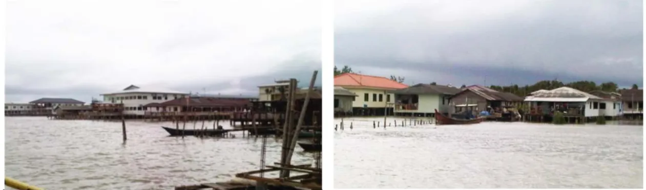
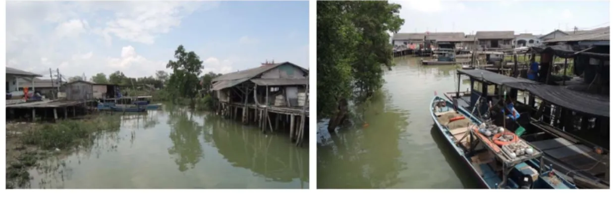
(15) Figure 1.1 Pontian District and Location of Study Area Source: Wikipedia (left); Google Maps (right) According to inhabitants, the villages were formed by the foreign immigrants from China around 150 years ago. The inhabitants had been conducting fishery activities since the villages were formed and started to operate fish farming from 1970s and tourism from 1990s. Kukup Laut Fishing Village built by immigrants from Kinmen County of Fujian Province, China (now is named Kinmen County of Fujian Province, R.O.C.) consists of around 170 units of buildings and 1000 inhabitants (around 120 families), 5 temples and 1 primary school. Ayer Masin inhabited by immigrants from Tong’an County of Fujian Province, China (now is named Tong’an District of Xiamen City, Fujian Province, P.R.C.) consists of around 120 units of buildings and 700 inhabitants (around 80 families), 6 temples and 1 primary school. There are over 90% of inhabitants in these villages remain as descendants of the immigrants1 and speak Min Nan dialect. Both villages are included in the study because of their adjacent geographical location (which the villages are separated only by a town road), similar forming background and lifestyles. However, these two. 1. The villages were considered illegal and had been obtained Temporary Occupation License (TOL) from. land use authority before they granted land ownership on year 2012. To limit the expansion of settlement, TOL application restricted the applicants of land use provide identity to prove as the descendants of original immigrants. It unintentionally led to the result of maintenance of villages’ ethnic.. 4.
(16) villages do not recognize each other as same living community due to their strong ethnic consciousness.. Figure 1.2 Photos of Kukup water villages Source: photographed by the study It has considered in several factors when setting these fishing villages as study case: 1) Relatively simple cultural factor control As a result of strong identity consciousness, the villages remain to inhabit only descendants from original immigrants and the historical record has been generally inherited to existing generations. It assists the research to observe in depth the context of development under condition of a relatively simple culture structure. 2) Availability of data and figures While most of the water settlements have not yet obtained legal position, these villages were the first that officially granted land ownership rights from the state government 2 and hence make official statistics available. Furthermore, the location adjacent to an international renowned national park provides comparatively diverse research perspectives to a less attention study object.. 2. The Chief Minister of Johor State Datuk Abdul Ghani Othman explained at the land grant ceremony, that. the land on shore of the Straits of Kukup is owned by the state government and thus held the rights to grant the ownership. The Kukup traditional water villages’ case is the first and only legal water settlement by now. The 99-years land ownership, which the local called “on-water ownership”, was granted on March 2012. Previously, the residents, just as in other states, often faced difficulty in receiving land ownership and the risk of eviction. Most of the residents had been only given Temporary Occupation License (TOL) for the past decades.. 5.
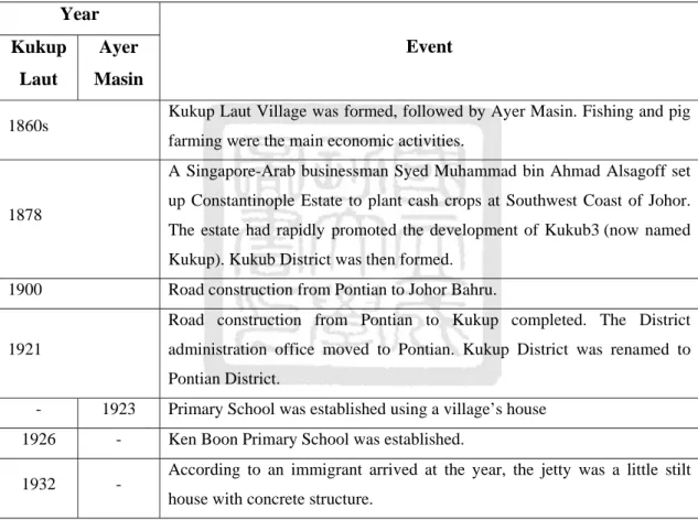
(17) 1.3.2 Time scope This research examines local perception reflected on spatial pattern development. Therefore, time scope is designed based on the stages when the spatial development was apparent and supported by available graphics and maps. Furthermore, a time sequence helps the study clarify the cause of spatial development by spotting the significant change at specific period. A summary of the village’s development is produced according to interviews with inhabitants, news and written records. Table 1.1 Summary to Kukup Laut and Ayer Masin Fishing Village’s Development Year Kukup. Ayer. Laut. Masin. Event. Kukup Laut Village was formed, followed by Ayer Masin. Fishing and pig. 1860s. farming were the main economic activities. A Singapore-Arab businessman Syed Muhammad bin Ahmad Alsagoff set up Constantinople Estate to plant cash crops at Southwest Coast of Johor.. 1878. The estate had rapidly promoted the development of Kukub3 (now named Kukup). Kukub District was then formed.. 1900. Road construction from Pontian to Johor Bahru. Road construction from Pontian to Kukup completed. The District. 1921. administration office moved to Pontian. Kukup District was renamed to Pontian District.. 3. -. 1923. 1926. -. 1932. -. Primary School was established using a village’s house Ken Boon Primary School was established. According to an immigrant arrived at the year, the jetty was a little stilt house with concrete structure.. The authority and prosperity of the development project owned the rights to issue private currency (see. appendix (3)), which clearly shown the name of “Kukub” and its function to make payment for coolies. “Coolies” was the word used in the early 1800s for Chinese laborers. The currency, hence, provides official document to support the oral history of settlement formation time.. 6.
(18) Year Kukup. Ayer. Laut. Masin. Event. According to an immigrant arrived at the year, the villages had no electric and running water service. There were only a few stilt houses with roof of 1936. -. sago palm’s leaves (attap in Malay). Kukup road was paved with stone and red soil. Ayer Masin had no path connected to Kukup road and the villagers rode wooden boat (sampan) to land.. 1938. -. Relocation of primary school to Kukup road.. -. 1940. Construction of primary school.. -. 1950s. Construction of wooden path (commonly apply as “qiao-lu” in Chinese) to connect the village with Kukup road under the pressure of post-War government.. -. 1960. School decoration to concrete structure.. 1970s. Infrastructure of lights, running water on Kukup road. 1970s. On stilt fishing facility (Kelong) gradually be abandoned.. 1970. Broaden Kukup road and asphalt paved.. -. 1977. Part of village path was destroyed by waves. Sea pollution on the Straits of Malacca brought impact to fisheries.. 1979. Developed floating fish farms.. 1981. -. Houses collapsed due to mudslide.. 1984. -. Set up Kukup fish farming trade union. 8 operating fish farms.. 1990s. -. tourism.. 1990. Infrastructure of lights on the path and in-house electric.. 1991. -. -. 1991. 1992. -. Houses collapsed due to mudslide. Decoration to school and expanded to 2-storey Village Fire, 4 houses were destroyed. Decoration to village path to concrete structure. New jetty with concrete. 1993. structure be built. 2006. 2012. commercial shops and a bus terminal on land. Village house decoration to concrete structure. Developed home stay. 1990s. -. Landfills beside Kukup road. Construction to 55 units of 3-storey. Village Fire. Received ownership of land.. Source: summarized by the study 7.
(19) It can be found that most of the infrastructure and facilities were completed by 1970s, although precise year of some constructions are hard to verify. After 1970s, there were structure improvement and alteration in an effort to deal with the impact of waves, pollution, fire disaster, that apparently caused changes to its spatial pattern. In addition, the earliest panoramic image in the settlement was at 1970. So the study period is designed to be two temporal phases4: a) Phase before 1970; and b) Phase after 1970.. 1.4 Literature Review This section stresses on reviewing related theories and research in four parts: 1) Study of spatial pattern development: water settlement is built on artificial space above water. Water, as the base of the settlement, led to unique consideration to building and community’s spatial pattern. In order to design specific perspective for the study of water settlement’s spatial pattern, it is important to review existing theories which interprets the formation of settlement occurred in natural settings and the spatial components used to observe and analyze spatial pattern. These basic knowledge is important references for this study to identify water and other physical or socio-economic factor to water settlement’s spatial pattern. 2) Study of water settlement in local and foreign cases study: reviewing previous studies in water settlement offers diverse perspective of concern and methods used to deal with such issues. It helps expand the horizon of this study. 3) Study of traditional Malay architecture in aspects of spatial pattern and architectural forms: the study of Malaysia water settlement is minimal and some former studies classified water settlement into traditional Malay architecture. Hence, it is important to review spatial characteristic of traditional Malay architecture in order to identify the feasibility of water settlement.. 4. Nevertheless, this study understands that spatial development is a constant process; hence, the designed. phases are only applicable in this specific study in consideration of available spatial and map data. Some of the development which could not be precisely traced or fit into the designed phases will be noted particularly in the description.. 8.
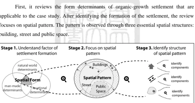
(20) 4) Study of resilience and adaptation of coastal or flood-prone area: The objective of this study is to discuss spatial pattern in adapting to coastal environment. Thus, the review of adaptation and resilience to climate change impact is important to examine the possibility of local resilience. 1.4.1 Study of spatial pattern development Water settlement has gained little attention in former spatial research. Hence, this study refers general theory of spatial development to design specific interpretation that applicable to the study case. Corresponding to the characteristic of water settlement, literature review focuses on the study of traditional and organic-growth (relative to planned) settlement. The structure to literature review is shown as Figure 1.3. First, it reviews the form determinants of organic-growth settlement that are applicable to the case study. After identifying the formation of the settlement, the review focuses on spatial pattern. The pattern is observed through three essential spatial structures: building, street and public space.. Figure 1.3 Diagram of spatial development's literature review Source: illustrated by the study It is found that, various studies in traditional and organic-growth settlement can be applied to this case study, which will be described in the following section. But, do note that, none of these studies develop from a water-base site. Hence, it can only provide reference to pattern components; the influence of water-base site (despite of ground-base) to pattern will be described in analytical results.. 9.
(21) I. The form determinants of settlement Settlement is a collective unit that human beings form for group living, that can be classified by spatial scales including village, rural town and city (R. C. Chen, 1993). By reviewing its spatial form, it provides clue to track the background and factor(s) of a settlement’s formation. The factor then becomes an important object to be observed in the study under the hypothesis that the change of factor leads to the change of spatial characteristic. According to Morris (1994), the form of settlement has been determined by factors and influences which shall call urban form determinants. The form of a settlement at any given period is the result of a number of locally effective determinants. The determinants can be classified into two different origins: a) natural world determinants and b) man-made determinants. Besides these two origins of determinants, an introductory consideration is also required of underlying reasons for the existence on their sites of settlement, which are called locational determinants. It is a concept grounded on the natural-world and manmade determinants, which some of them must be the essential prerequisites for a settlement’s existence, for example availability of permanent potable water supply and food. Natural world determinants are those that originally exist in the natural environment of the geographical location of a settlement. The most significant determinants are topography, climate and available construction materials in surrounding environment. Topography consists of natural constrains and advantages that may influence the geographical extent and direction of growth, make it a main part of a settlement’s form. Local climate circumstances bring impact to the form of the shelter when it attempts to response. On the other hand, unexpected climatic or natural disaster can also lead to changes and adjustment of a settlement and its shelter form. Availability of local construction material plays a major role in traditional settlement’s form due to accessibility. On the other hand, it also decides the form of the shelter depending on the performance. 10.
(22) characteristic. These determinants will be discussed in the water settlement’s forming background focusing on the natural environment that attributes to the settlement5. Man-made determinants are various, continuously increasing and much more complex in nature and the effect. However, they can be summarized into three primary motivating forces - trade, political and social power, and religion6. It provides a check-list for the study to analyze water settlement past and present spatial development. II. The pattern of settlement Spatial study can be conducted in various theoretical approaches such as typology, morphology, pattern and form. Due to the spatial study of water settlement very limited, the research resources is sufficient to support a comprehensive analysis or classification of a settlement’s type or form. As one of the preliminary studies, this research aims to provide in-depth case analysis by exploring the underlying spatial pattern of the chosen site to identify the force that shaped the pattern and the unique characteristic of spatial structure. It is based on the assumption that an organic-growth settlement has a unique and distinct pattern that is shaped by grassroots’ perception and their long-established practice on space. It is similar to the argument of Alexander, Ishikawa, and Silverstein (1977), that every town and buildings is made by people in the society who share a common language, and the elements of this language are entities called pattern. Hence, pattern can be defined as a kind of conscious arrangement of buildings into a predetermined form(Morris, 1994).. 5. To be noted, the author suggested that the influence of natural-world determinants especially topography. and local construction materials is reduced after new construction technology evolved. This explanation does not exactly fit with the current state of this case study where the intercourse between water settlement and nature environment is still frequent. However, as this study orientation focuses on spatial pattern, it refers to the impacts of natural-world determinants only for discussing of the origin of settlement formation. Thus, the argument, though not consistent with the current form, will not be discussed in this study. 6. The author suggests that “not only have these forces had major determining effects on historic urban. morphology, but also singly, or in combination, they have been mainly responsible for urban formation and growth…while it is urban history’s exceptional results of trade, power, religion and other such determining influences that are conventionally highlighted, the great background mass of ordinary urban development has been shaped by mundane everyday requirements.” (Morris, 1994: p12-13). 11.
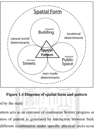
(23) According to Alexander et al. (1977), a pattern language is considered a structure of network. The network is configured by both the scale (from larger pattern to the smaller) and the function (from the structure to the embellishment). The application of different sequence of pattern makes different language and can be considered as the “base-map” of a particular project7. A community scale pattern is organic growth and can be observed from its network connection and boundaries, local environment, growth of housing, and public land for human activities. Pattern at building scale defines the individual buildings and the space between buildings. The overall arrangement of a group of buildings shows its pattern at the height, number of these buildings, the entrances, parking areas and the lines of movement. These languages fix the position of individual buildings on the site while the components of indoor and outdoor space shape both the volume of the buildings and the volume of the space between the buildings. When the major parts of buildings and the outdoor areas have been given their rough shape, their internal gradients of space and movement define the most important area of a building. While the pattern above gives a scheme of spaces, the final part will be the structural details including construction and materials. This study will produce a structure of pattern language network according to the study result as a reference of the water settlement’s base-map that may contribute to further study to distinguish similar water settlement. Refer to the literature of form and pattern, the study develop specific interpretation of the terms applicable in this case study. The relation between spatial form and pattern is interpreted as the diagram shown as Figure 1.4. 1) Form: a visible shape molded by form determinants. 2) Pattern: a kind of conscious arrangement that represents the uniqueness of a shape. 3) Structure: the essential elements to configure form and/or pattern particularly buildings, street, and public space in this study.. 7. To be noted that, the book aims to standardize universal pattern in order to design a good project. But in. this study, we only refer to the components it summarizes to support the observation of the site, and using the concept of “structure of network” to analyze Kukup water settlement’s spatial pattern (without the intention to standardize general design rules of water settlement).. 12.
(24) 4) Component: used to describe object(s)’ underlying structure to configure the characteristic of structure. Figure 1.4 Diagram of spatial form and pattern Source: illustrated by the study Spatial pattern acts as an outcome of continuous history progress and ongoing daily life. The uniqueness of pattern is generated by interaction between buildings, street and public space in different combination under specific physical socio-economic conditions (Lin, 2006). It thus reflects the characteristic of these three structures in different phases (provided they have not been destroyed) as a record of the process of spatial development. On the other hand, physical socio-economic conditions can be summarized into two major categories - “environment” and “human activities”. Hence the interpretation of the spatial pattern development in this case study shown as Figure 1.5, implies spatial pattern is corresponding to “coastal environment” and “human activities”. The continuous interaction between these two major factors shaped the uniqueness of water settlement’s pattern. The pattern can be recorded through the analysis of its structures: buildings, street and public space. By observing pattern, we are able to track and derive the socialenvironment relations and community relationship within a water settlement. 13.
(25) “Coastal environment” in this study is used to describe specific natural settings at Kukup water settlement - saline water coast with mangrove fringed and swampy mud ground in tropical climate.. Figure 1.5 Shaping process of water settlement's spatial pattern Source: illustrated by the study Combined with the literature review, the study took reference from the “structure network” of Alexander et al. (1977) when conducting study at community scale and building scale to record spatial pattern by analyzing the characteristic of its three essential structures. Followed by the list of components, the uniqueness of the pattern at community scale can be observed through the combination of building, street and public space, while the pattern at building scale can be observed in its distribution and construction details. III. The spatial structure of settlement A settlement can be treated as an organic unit basically formed by buildings (Hillier & Hanson, 1984) or dwellings place (Sha, 1974). The major structural units of a settlement include housing, facilities, routes and road (F. H. Chen, 1984). They are not only the transformation of space through objects, but also “create and order the empty volumes of space resulting from the object into a pattern” (Alexander et al., 1977). The process of space transformation through object into pattern can be observed apparently in water settlement where building, street and public space that are entirely built upon an artificial platform on stilt then transformed from a waterlogged space into a 14.
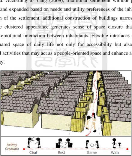
(26) settlement. The settlement pattern gradually forms during the interaction between these objects. In the beginning, water stilt houses, the fundamental object in the settlement, were distributed randomly and isolated at riverbank and coast without road connection. It transformed natural territory into artificial. Gradually, other types of object including road and public space were constructed and bring transformation to the original pattern. Hence, buildings are considered the fundamental structure in the study while its construction and layout has proactive influence to other spatial structure. Furthermore, street and public space bring diversity to the structure of settlement and through the interaction between these structures, the pattern is gradually shaped. In an organic-growth traditional settlement, the function of street and public space can be varied. According to Yang (2009), traditional settlement without planning was usually built and expanded based on needs and utility preferences of the inhabitants. Due to the growth of the settlement, additional construction of buildings narrows the street. However, the clustered appearance generates sense of space closure that encourages physical and emotional interaction between inhabitants. Flexible interfaces of the streets become a shared space of daily life not only for accessibility but also for various neighborhood activities that may act as a people-oriented space and enhance activity within the community.. Figure 1.6 Flexible interfaces of streets in traditional settlement Source: Yang, 2009: p. 57 15.
(27) The multifunction of a street which stimulated from space closure applies to Kukup water settlement. Street acts as a public space for activity and is applied to observe community interaction in the study. “Public space” in this study is defined by the concept of social production referred from Hsia (1994) that including space for social life, consciousness, spiritual and physical activities. Public space consists of “representation of public space” (imagined space), “representational public space” (lived space), and “real public space” (real space) shown as Figure 1.7.. Figure 1.7 The social production of public space Source: Hsia, 1994: p 15 “Representation of public space” is resulting from symbolic practice, discursive practice and ideological practice that produces an imagined space. “Representational public space” is consciously living space that physically exists and “real public space” is a configured by physical public facility and service. The public space of Kukup water settlement fits into this concept and expands from these three dimensions. Initially, the sea and surrounding mangrove forest formed an imagined space that defined their collective identity. Afterwards, some physical space within the neighborhood gradually stimulated social interaction and activities without. 16.
(28) planning and not necessary accompanied by public facilities. Finally, public facilities and services were produced in the process of urban planning and transformed into real public space in the community. As public facilities and services were not the primary public spaces in local villagers’ perception, it was crucial to understand the layout of public space by utilizing the definition of public space mentioned above. The following study in public space will be conducted within these three dimensions in order to define specific perception and characteristic of public space in water settlement. 1.4.2 Study of traditional water settlement in local and foreign cases Former studies in traditional water settlement in Malaysia are limited and mainly surfaced due to concern of heritage preservation of its community pattern. These studies, however, provide preliminary but important introduction of water settlement in Malaysia that helps identify the influences of environment and human activities to the pattern. A review of Hong Kong Tai-O village is applied in this study for its similar ethnics and lifestyle which was built by the Chinese with the original intention of fishery. Furthermore, the study of Netherlands water buildings provides basic knowledge to water building construction including the consideration of ground and water condition. This section is organized by the study scaling at community and building in order to fit into the designed structure of this study. I. Community scale concern to spatial pattern and landscape According to Hassan (2010), existing Malay village settlement can be classified into two types - traditional fishing (water) 8 and rural villages. One of the major differences between water and rural village in pattern is housing unit density per hectare. Water village has relative high density in low rise9 housing than low rise housing in rural village.. 8. The definition of “fishing village” in Hassan’s study is equal to the term “water settlement/village” in this. study. The following description uses “water settlement/village” despite of “fishing” in consideration of consistency. 9. The author mentioned that “Low-rise means the houses with one story houses and low density… Low. density means 4 or less housing units built in one acre, which typifies a typical traditional Malay houses in rural areas ranging from 1 to 4 house units per acre”. 17.
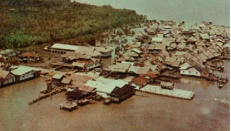
(29) Water village has similar pattern to traditional old Malay port city based on historical records. It evolved highly related to local livelihood and natural settings and thus, preliminary survey to local geographical and topographical condition is essential to analyze spatial form of water settlement.. Figure 1.8 Port City during Johor Sultanate Kingdom in 16th Century Source: Courtesy of Kota Johor Lama Museum The research found that water village was usually built along coastal area to leverage the strategic location for fishery activities. Existing curvilinear topographical contour line plays a significant factor in influencing the development of the spatial pattern. For internal spatial pattern, he classified the distribution into several temporal layers and found that the first layer of settlement commonly included jetties, workshops and houses proved that livelihood is the essential element of a settlement’s set up. According to the original locations and direction of expansion, he summarized in the settlement patterns into five types - inland water village, outward water village, parallel water village, water village and river mouth water village shown as Figure 1.9.. 18.
(30) Figure 1.9 Patterns of water village Source: Hassan, 2010 Original location and topographical condition mentioned in the study can be considered as nature world determinant mentioned in spatial form review. This study, hence, supports the perspective that the form of water village is highly related to the nature settings. Kukup Laut water village and Ayer Masin water village fit into the pattern category of parallel water village and river mouth water village. Another case study of water settlement in Chew Jetty, Penang provided reference to local sense of place (Ng, 2013). The study found that, water village’s patterns, proximity and scale of the built environment were apparently different from outside the neighborhood and contributed to a sense of community. This sense of place10 of water village derives from the pattern of road and routes (which is the major structural object the study discusses), its interaction with human activities and the way this space being used. The wooden path is not only for accessibility but also promotes interaction between inhabitants,. 10. The author summarized the common grounds of definition of “sense of place”: (1) it comprises of a. combination of characteristics (physical and socio-cultural elements) that collectively constructs a particular sense of place, and differentiates it from others; (2) sense of place is temporal; and, (3) sense of place is experienced.. 19.
(31) and between inhabitants and visitors. It invites more visitors to the village and has become a space to experience “local sense of place”. The patio became the buffer space between public and private territories, while the size of path also led to different “sense of place”. It appears that smaller path expanded from the main path led to comparative private space that is usually used only by inhabitants. Furthermore, the overall view consisting of temples, boat, children, inhabitant’s activity on the patio and temples also offers a nonstatic place identity and sense of place. Although the sense of place is not a major focus in this study, it provides an in-depth reference to the activities and functions of road and routes of the water village that constituted the representation of public space. From the socio-economic aspect, Leung (2002) analyzed the impact of urban development to water village’s natural, cultural and social environment using case study of Hong Kong Tai-O water village. In the case study, the layout development of building and community was described in detail which assists to observe local perception of living on water. This study adopted this approach to observe community pattern’s development. Furthermore, Current urban issues such as environmental pollution, tourism industry, inadequate infrastructure and change of surrounding landscape also caused large impact to preservation of the original layout of the village. Hence, the effort to encourage communal participation and culture connotation in pattern preservation is necessary to enhance proactive action.. Figure 1.10 Spatial development layout of Hong Kong Tai-O water village Source: Leung, 2002 20.
(32) Similar to Tai-O, Clan jetties in Penang in the study of Chan (2011) is facing high pressure from urban development that may destroy its original pattern and lifestyle if the development plan does not heed local opinion. The issues being discussed included the disturbance to the locals’ private life caused by mass tourism, lack of funding for regular repairs and maintenance of wooden structure, poor environmental conditions and natural hazards, poverty and migration of young generation. It can be found that the village pattern that was originally shaped to service the inhabitants has increased conflict from the visitors’ demand in the midst of urban development and the challenge facing Kukup villages’ pattern. II. Building scale concern to construction and materials The review to the Netherlands water architecture provides perspectives to individual building structure. According to Olthuis and Keuning (2010) in the study of the Netherlands water architecture, the first forms of living on water were rafts with huts on them, followed by wooden houseboats and barges. Later version had a steel understructure but retained the disadvantage of maintenance. Wooden and steel houseboats and barges have to pay regular visits to the boatyard for maintenance usually every five years. The development of floating foundation is then be proposed following on the invention of reinforced concrete. Reinforced concrete is a combination of concrete and steel bars and requires far less maintenance to the foundations. It claims that, the only essential difference between a house on water and a house on land is related to the foundation but not the structure. Different sorts of water have differing characteristics that influence the building type. In another hand, different kinds of water, for instance, fresh, brackish, salt and acidic water are considered with different effect on building materials. There are two main types of foundation in use in the Netherlands which are dry regions consist of sandy ground and wet-boggy ground. And different foundations are used according to the ground conditions: 1) Spread foundation That is a method of foundation used in dry region and requires a good ground base. The walls have a broadened foot that rests on the bearing substratum.. 21.
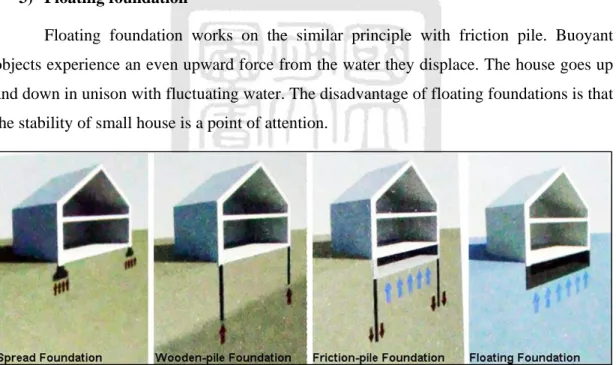
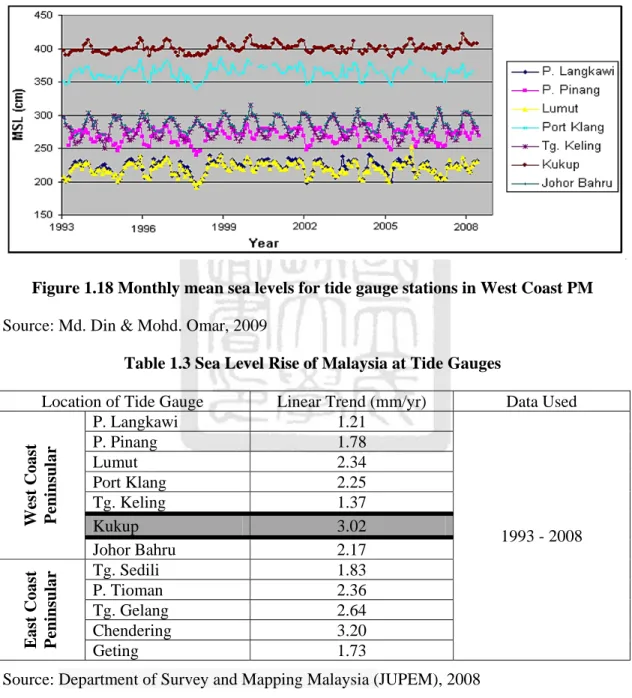
(33) 2) Pile foundation It includes wooden-pile and friction-pile foundation. It is suitable for the marshy ground but the ground has to be consolidated when start construction or else the buildings subside. Wooden pile-foundation had been used in many old buildings and currently be harmed by the fluctuating groundwater levels. Climate change causes more severe rainfall to the city and water levels can be expected to fluctuate more. Pile rot is a main threat to this wooden-pile foundation now. Friction pile foundations have been used widely too. The building does not rest on the piles. The friction between the piles and the base layer keeps the building down; otherwise start to rise due to the upwards pressure of the groundwater. The basements lie partly in the groundwater in these cases. 3) Floating foundation Floating foundation works on the similar principle with friction pile. Buoyant objects experience an even upward force from the water they displace. The house goes up and down in unison with fluctuating water. The disadvantage of floating foundations is that the stability of small house is a point of attention.. Figure 1.11 Diagrams of spread, wooden-pile, friction-pile, and floating foundation Source: Olthuis & Keuning, 2010: p. 51 Water architecture emphasizes on the security and selects construction technique and material according to natural conditions. The ground base, water properties, and also, the maintenance of material need to be considered to ensure the building sustainability. It will be applied in the research to examine the construction and environment function of traditional water stilt house. 22.
(34) 1.4.3 Study of traditional Malay architecture As water stilt house and traditional Malay house have similarities to their building structure and materials, while the literature of local water stilt house is rare, it is particularly important to review Malay house’s structure, spatial characteristic, and construction way as reference of water stilt house’s spatial component. I. Community scale concern on spatial pattern The Kampong is Malay rural settlement which generally sustained by agricultural activities for example fishing and rice-growing. According to Lim (1987), some common features of its spatial characteristic including: 1) Random layout The layout of a kampong is not apparently observed. Traditional Malay houses were randomly distributed and therefore appeared free-standing. The sites of house are traditionally selected by owner’s observation and religious rituals. The space between houses is far to ensure further expansion of living area, privacy and planting. 2) Private and public space The boundary between private and public spaces is hard to define as house compounds are usually open and unfenced and merging with public spaces. Another semiprivate space is the open bottom of the raised floor acts as place for work, chat, and also storage. 3) Free-flowing path The connection of houses is by free-flowing paths. The paths are not “designed” and “built” with particular intention but gradually generated due to the needs of accessibility. The shape of paths is not apparent to observe as many of them merge into open compounds of houses. Main roads are occasionally built for accessing from and to town.. 23.
(35) Figure 1.12 External environment of the Malay house Source: Yuan, 1987. Figure 1.13 ‘A Malaye Village’, drawn and engraved by T. & W. Daniell, 1810 Source: Moore, 2004: p. 27 24.
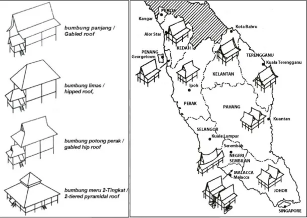
(36) II. Building scale concern on construction and materials Traditional Malay houses are mainly classified by their roof shapes (Abidin, 1981; Lim, 1987; Nasir & Teh, 1996). There are bumbung panjang or gabled roof, bumbung limas or hipped roof, bumbung potong perak or gabled hip roof, and bumbung meru 2Tingkat or 2-tiered pyramidal roof (Ismail, 2005) shown as Figure 1.14.. Figure 1.14 Type of Malay house and the distribution in Peninsular Malaysia Source: Ismail, 2005: p.15&16 Typically, a traditional Malay house can be divided into several important components shown as Figure 1.15 and Table 1.2. According to Nasir and Teh (1996), pillars, walls and roof are three main parts in traditional Malay house. The construction components are first made on the workshop and later assembled on the site. Various mortis and tenon, lap and dovetail joints are used in the construction. Wooden dowels were used and then replaced by nails. A pattern of additional construction shows the extension sequence and growing needs of the users (Figure 1.16).. 25.
(37) Figure 1.15 Diagram of basic components of traditional Malay house Source: Chen, 1998: p. 20 Table 1.2 Basic components of traditional Malay house Components a) Rumah ibu or Core house. Description . The largest area in the house where most activities are conducted.. . The importance of the rumuh ibu is expressed by its floor level being the highest in the house.. b) Dapur or Kitchen. c) On stilts. . It is always situated at the back of the house, and is on the lowest floor level.. . Raised floors to prevent floods and animals.. . Space under the house as a storage area for rearing animals or as a working area.. d) Stairs. . Located at entrance to lead up to a covered porch.. . Acts as an important focal point for the entrance.. e) Anjung or Covered . domains.. porch. f) Serambi gantung or Hanging verandah. Acts as a transition space between the public and the private. . Unfamiliar visitors and guests are entertained here.. . The place where most guests are entertained.. . Low windows here allow for good ventilation and views to the exterior.. 26.
(38) Components. Description . g) Selang. or. Closed. space between these two portions, allowing good ventilation and lighting for the house.. walkway. h) Rumah. Use to link the kitchen and the rumuh ibu, which leaves an open. tengah. Middle hall. . Used by the womenfolk as a space to chat and socialize.. . Intimate, private interior open space. or . The wet core of the house where washing, drying and toilet areas Resting place, informal guests especially ladies, are entertained here.. Source: Lim, 1981: p. 76&77. Figure 1.16 Basic construction methods and additional sequence of Malay house Source: Ismail, 2005: p. 17 The materials used to build the houses are basically those found locally in the jungles. Timbers were used commonly for the pillars and basic structure, timber or bamboo for the wall and thatched roof. 1) Pillars: extremely good wood is used to support the weight of the house. The base of pillars was buried in the ground in early period. After then the pillars were given a foundation which usually made of wood or concrete. 2) Crossbeam: it served to secure the structural framework and made by wood.. 27.
(39) 3) Floor: made of wood from the Ficus plant species or from strips of the trunk of areca tree (pinang), or hollow bamboo about 5-6cm wide. 4) Open platform: made of nibong tree trunks split into halves and laid with slits inbetween to allow water to drain. 5) Stairs: made of wooden poles. Dovetailed planning was done at the joints between the rungs and the banisters to prevent from slipping. 6) Walls: leaves were used normally from the eugeissona trisis tree (bertam), the Baeckea frutescens bush (cucur attap), the sago palm, Metroxylon (rumbia), and the nipah palm. There were also wattlework walls from bamboo strips or wickerwork walls from bamboo. Beside, walls made from the bark of trees and planks were also found. 7) Doors and windows: the door consists of two boards that usually open inwards. The window opening is usually latticed. Doors and windows have wooden frames. 8) Roof: it consists of a wooden framework and cover by variety materials: leaves from Baeckia frutescens (attap cucuh, a jungle palm), the sago palm (attap rumbia), and the nipah palm. Literature review of traditional Malay architecture offers reference of pattern components that suitable to the observation of water settlement. Despite of the similarities between Malay house and water stilt house, the study concerns to the difference of their pattern too. It intends to verify the statement of former literature that water stilt house is in the category of traditional Malay architecture and will be discussed in details in chapter three. 1.4.4 Study of resilience and adaptation on coastal area The challenge of coastal settlement is not only to face potential risk of climate change but also continuous impact generated from tidal cycle and coastal erosion. Hence, policy to reduce vulnerability should not only focus on climate change adaptation but to design comprehensive plan towards resilient community. In this section, the review to adaptation and resilience intends to understand the complexity of policy making and the factors to be considered confronting risks. Besides, risks occur on Kukup settlement is also the primary concern of the review.. 28.
(40) I. Significant of local measures to resilience and adaptation Concern to climate change adaptation is usually a global perspective. The focus on the implementation on community scope only entered the local government agenda in the past 10 years. During the United Nations Johannesburg Summit in 2002—the World Summit on Sustainable Development (WSSD)—the international community came to realize that a sustainable city must be a resilient city. Resilience is the ability of a system, community or society exposed to hazards to resist, absorb, accommodate to and recover from the effects of a hazard in a timely and efficient manner, including through the preservation and restoration of its essential basic structures and functions (UNISDR, 2009). Crisis and disasters impose significant threats to sustainability and have the power to affect society, the environment, and economy. The capacity of a city to respond ‘creatively, preventively and proactively to change or extreme events, thus mitigating crisis or disaster’, is to be resilient (ICLEI-Local Governments for Sustainability, 2002). Hence, resilience goes beyond addressing only climate impacts and overcomes the only risk-oriented approach of disaster risk reduction which is more than successful climate change adaptation. It emphasizes the preparedness to extreme events, reduced vulnerability, and enhanced adaptive capacity. The concept of resilience, as a development approach, is able to address the complexity and the inter-linkages of challenges confronting local governments in cities of both developed and developing countries. In effect, ICLEI’s Resilient Communities and Cities Initiative was launched at the Local Government Session of the WSSD in 2002 to help local actors develop and implement local resilience agendas. The initial definition of resilience was applied most frequently to the literature on disasters, whereby local governments and disaster management communities recognized that building resilience to disasters was a crucial element in creating sustainable cities. Recent attempts to define and apply resilience have occurred against a build-up of ongoing debate on the readiness of our cities to effectively cope with the impacts of climate change. As such, there grew a common understanding among experts that cities need to improve their resilience to climate change impacts (e.g. ICLEI’s Climate Resilience Communities. 29.
(41) Program11). In turn, local governments are currently searching for tools to help protect their communities from the impacts and costs associated with climate change. This essential capacity can be described as ‘local resilience’ (ICLEI, 2004). The occurrence of climate change and natural disasters and the responses necessary for its management are inherently local. While policies for climate change mitigation and adaptation and for disaster prevention require national attention, effective action towards more resilient cities must be local and responsive to specific local conditions (OttoZimmermann, 2012). There is a strong need for greater attention to locally based efforts to reduce vulnerability and increase the resilience of local systems and institutions to climate change, crisis and possible disasters. Furthermore, as the risks and impacts of climate change disproportionally affect the most vulnerable in our society (e.g. elderly, urban poor, children, and women), social and economic concerns must be at the forefront of resilience thinking. Although city officials are increasingly more aware of this, the majority are still implementing measures aimed at coping with the impacts of climate change with a reactive rather than preventative approach due to constrain when trying to implement adaptation measures. These include insufficient funding, lack of coordination at different levels of governance, difficulty in building and conducting effective participatory processes with stakeholders, limited availability of knowledge and its limited exchange between actors and between cities, insufficient vertical and horizontal integration of instruments (Bucx, 2010), and lack of linkage between adaptation measures and local knowledge potentials(Otto-Zimmermann, 2012). In response to it, this study advocates to explore a grassroots, community-led response to climate change.. 11. ICLEI is an organization that facilitates local government input to United Nations (UN), processes such as. the UN Framework Conventions on Climate Change, and Biodiversity. In partnership with the UN and other organizations, as well as national governments, ICLEI puts in the groundwork for more ambitious and more responsible international commitments - and seeks global recognition and support for local action (ICLEI, 2004).. 30.
(42) II. Local perception in adapting coastal environment Adaptation to coastal environment is a continuous progress to water settlement. It is just the great concern towards climate change that highlights the vulnerability and risks of coastal settlement. The environment accompanying by regular tidal impact and changing quality of ground has shaped local perception to live on water far beyond climate change concern. It should not be neglected in policy making of resilience and adaptation especially when the settlement is generally built by grass roots’ efforts and measures without much intervention of the authority. Local perception is developed highly depend on the life experience in the specific environment and its measures adopted. According to Newell et al.(2005), one of the principal challenges in urban study of human–environment systems is to understand the interactions between phenomena that occur at different temporal and spatial scales. For this the Layer model developed by Bucx (2010) is suited since it combines the spatial scale of each of the layer with the vertical differentiation in temporal dynamics. Each of the layers can be represented in map form, or as overlays in a GIS, enabling spatial analyses. Applied on spatial pattern development, it helps the study notice the influence of humanenvironment interaction at different spatial scales presented in temporal dynamics.. Figure 1.17 Layer model combines spatial scale with vertical differentiation in temporal dynamics Source: Bucx, 2010. 31.
數據
+7
相關文件
Department of Mathematics National Cheng Kung
Department of Mathematics National Cheng Kung
Department of Mathematics National Cheng Kung
Department of Mathematics National Cheng Kung
Department of Mathematics National Cheng Kung
Department of Mathematics National Cheng Kung
Department of Mathematics National Cheng Kung
Department of Mathematics National Cheng Kung
