行政院國家科學委員會專題研究計畫 成果報告
子計畫三:高雄分部及海研三號
計畫類別: 整合型計畫 計畫編號: NSC92-2119-M-110-001- 執行期間: 92 年 08 月 01 日至 94 年 07 月 31 日 執行單位: 國立中山大學海洋地質及化學研究所 計畫主持人: 許德惇 共同主持人: 劉祖乾,詹森 計畫參與人員: 洪國瑋、周文臣、郭芳旭、孫震南、陳建興、黃麗芳、洪蓮珠 報告類型: 精簡報告 處理方式: 本計畫可公開查詢中 華 民 國 94 年 10 月 13 日
行政院國家科學委員會專題研究計畫成果報告
國家海洋科學研究中心計畫-子計畫三:高雄分部及海研三號
計畫編號:NSC 92-2119-M-110-001-
執行期限:92 年 8 月 1 日至 94 年 7 月 31 日
主持人:許德惇 國立中山大學海地化所
共同主持人:詹森 國立中央大學水文科學研究所
共同主持人:劉祖乾 國立中山大學海地化所
計畫參與人員:洪國瑋、周文臣、郭芳旭、孫震南、
陳建興、黃麗芳、洪蓮珠
國立中山大學海地化所
中文摘要
本成果報告旨在彙整過去兩年間海科中心高雄分部之主要工作。依原計畫申請之內 容,分部執行之工作主要有四項:(1)南海時間序列碳化學分析和研究,(2)台灣鄰近 海域 NOWCAST 研究,(3)沉積物通量實驗,及(4)海研三號貴儀中心之採購及管理。 各項工作完成之情形和項目請參閱以下各分項報告之說明。 關鍵詞: 南海時間序列、NOWCAST、沉積物通量Abstract
This abstract summarizes the works conducted by the NCOR-Kaohsiung branch during the past two years. As originally proposed, these works consist of 4 major items, namely (1) carbon chemistry at the SEATS site, (2) NOWCAST study on the surrounding seas around Taiwan, (3) sediment trap deployment and subsequent sample distribution, and (4) instrumentation and facility support for R/V Research I. Details of these works can be found in the following individual report.
(Key words : SEATS、NOWCAST、sediment trap )
1. 南海時間序列碳化學研究部分
高雄分部自 91 年 7 月起接手負責南海時間序列研究計畫中,碳化學參數之 分析工作。分析項目包括海水之酸鹼值(pH)、溶解態無機碳含量(dissolved inorganic carbon, DIC)及總鹼度(total alkalinity, TA)等三項。在計畫執行期間, 共參與了 ORI-690(92 年 8 月)、ORI-696(92 年 10 月)、ORI-705(92 年 12 月)、
ORI-711(93 年 3 月)、ORI-717(93 年 5 月)、ORI-726(93 年 8 月)及 ORI-736 (93 年 11 月)等七個 SEATS 航次,總計分析水樣約 300 個。所有分析數據均 已準時繳交至海科中心台北總部,曾鈞懋博士所負責之 SEATS 資料庫進行彙整。 此部分之工作已協助完成中山大學海地化所周文臣同學之博士論文。具體 之工作成果在周文臣博士的論文中有詳盡的說明與討論。此外,部分之研究結果 亦已於國內、外之學術研討會及相關之學術期刊中發表。已發表之會議摘要及期 刊論文臚列如下: (一) 會議摘要
1. Sheu, D.D., W.C. Chou, 2003. Seasonal variability of seawater δ13
C at the South China Sea time-series station. JGOFS Final Open Science Conference Program Abstracts, May 5-8, 2003, Washington, D.C., USA, p71.
2. 周文臣、許德惇、陳鎮東、曾鈞懋、孫震南、施詠嚴,2004,Vertical distributions of alkalinity, TCO2 and δ13CTCO2 at the South East Asia
Time-series Station (SEATS): Controlling processes and anthropogenic CO2
influences,2004 年海洋科學成果發表會論文摘要集,2004 年 5 月 17~19 日,39 頁。
3. 曾鈞懋、李丙生、周文臣、許德惇、黃天福、劉康克,2004,Temporal variability of upper-layer oceanic CO2 species at SEATS,2004 年海洋科學
成果發表會論文摘要集,2004 年 5 月 17~19 日,40 頁。
4. Chou W.C., Sheu, D.D., Chen, C.T.A., Tseng, C.M., 2004. Depth variations of alkalinity, TCO2, and δ13CTCO2 at SEATS Time-series Station, Northern
South China Sea, 2004 Western Pacific Geophysics Meeting Abstracts, August 16-20, 2004, Honolulu, Hawaii.
5. Tseng, C.M., Lee, B.S., Chou, W.C., Sheu, D.D., Wong, G.T.F., Liu, K.K., 2004. Temporal variability of upper-layer oceanic CO2 species at SEATS,
2004 Western Pacific Geophysics Meeting Abstracts, August 16-20, 2004, Honolulu, Hawaii.
6. 周文臣、許德惇、陳鎮東、王樹倫、曾鈞懋,2004,Preliminary study on seasonal variability of mixed-layer CO2, alkalinity, and fCO2,海峽兩岸第 6
屆(2004 年)海洋科學研討會論文集,2004 年 8 月 27~30 日,68-69 頁。 7. 周文臣、施詠嚴、許德惇、楊穎堅、曾鈞懋,2005,Estimated net community production during the summer season at the SEATS site,2005 年海洋學門研 討會,2005 年 3 月 28~30 日,89-90 頁。
(二) 期刊論文
Chou, W.C., Sheu, D.D., Chen, C.T.A., Wang, S.L., Tseng, C.M., 2005.
South China Sea between 2002 and 2003, Atmospheric and Oceanic Sciences 16, 445-465.
此外,目前尚有 3 篇期刊論文正在撰寫階段,分別為:
1. Chou W.C., Sheu, D.D., Chen, C.T.A., Tseng, C.M.. Depth variations of alkalinity, TCO2, and δ13CTCO2 at SEATS Time-series Station, Northern
South China Sea. (in preparation)
2. Tseng, C.M., Lee, B.S., Chou, W.C., Sheu, D.D., Wong, G.T.F., Liu, K.K.. Temporal variability of upper-layer oceanic CO2 species at SEATS. (in
preparation)
3. Chou W.C.,Shih, Y.Y., Sheu, D.D., Yang, Y.J., Tseng, C.M.. Estimated net community production during the summer season at the SEATS site: implication for nitrogen fixation. (in preparation)
其中第一及第二篇欲投稿至預定於 2006 年出刊之 Deep-Sea Research II
“SEATS/SCS biogeochemistry”專刊。第三篇則預定投稿至 Geophysical Research
Letters。
整體而言,此部份工作之進展堪稱順利,研究成果亦尚稱豐碩。唯就海洋時間序 列研究角度言之,目前所累積之資料量,尚無法對較長週期之海洋現象(例如聖嬰-反 聖嬰現象)與南海碳化學系統可能變化之相關性進行解析。故維持此部分工作持續進 行,以便長期系統性地收集南海碳化學數據,有其絕對的必要性。
2. Progress report of Taiwan Surrounding Seas Nowcast Study (TSSNOW)
Sen Jan
Institute of Physical Oceanography, National Sun Yat-Sen University Institute of Hydrological Sciences, National Central University
Abstract
A 2-D tide model for the Asian marginal seas and a 3-D circulation model for the Pacific Ocean have been developed prior to the development of a 3-D higher
resolution, smaller domain nowcast system for Taiwan surrounding seas. The 1°/8 tide model was calibrated to the accuracy fitting the request of the present study. The 1° circulation model driven by climatological hydrography and wind stress was spun up to a quasi-steady state. Results derived from the two models will be coupled for the boundary conditions of the TSSNOW model.
Introduction
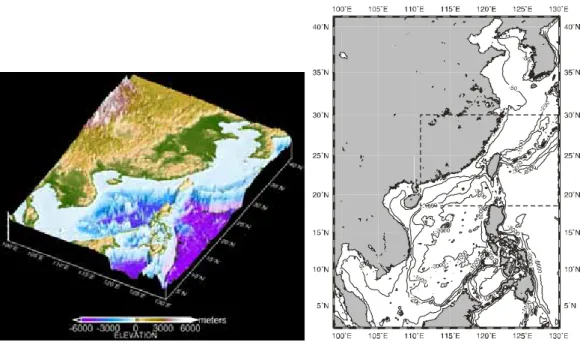
In 1998-2003, the National Center for Ocean Research (NCOR) has successfully established the infrastructure, capability and skill to operate a nowcast system of sea levels, currents, temperature and salinity for the Taiwan Strait (TSNOW) (see Fig. 1 for the location). Along with TSNOW’s development, research ship and moored instruments acquired hydrography and current data were well-organized in a data archive providing useful information to oceanographic investigations. The model predicted currents have been timely used in marine searching/rescuing missions, recovering of sank wreckage, prediction of marine contaminant dispersion, etc. The objectives of TSNOW documented in the origin proposal were mostly accomplished. Relevant achievements, e.g. the development of an inversion method for the
determination of boundary conditions and the understanding of hydrography, tidal characteristics and throughflow transport in the Taiwan Strait, were published in Jan et al. (2001, 2002a, 2002b, 2003a, 2003b) and Wang et al. (2003). Through
aforementioned remarkable applications, general publics and government departments recognized the importance and difficulty of developing and maintaining such a
nowcast system for the marine affair.
However, the limited TSNOW domain hampers its application to seas around the island of Taiwan. The importance and urgency of establishing an operational nowcast model for seas around Taiwan remain. With this concern in mind, support for the development of the Taiwan surrounding seas nowcast system (TSSNOW), with the ultimate goal aimed at enhancing our national ocean nowcasting/forecasting capability, is requested. The model domain is enlarged to within 111° and 130° meridians and 18.5° and 30° parallels (see Fig. 2) with a horizontal resolution of 1°/12
(approximately 9.2 km). There are 30 layers in the vertical with varied layer thickness. The open boundaries are set over the northwest Pacific (130° E), the East China Sea (30° N), and the northern South China Sea (18.5° N). The NODC’s 5-minute depth archive ETOPO5 supplemented with NCOR’s 1-minute Taiwan surrounding seas depth data will be used to establish model topography. Open boundary conditions relevant to tidal sea levels will be taken from a larger domain 2-D (1°/12 resolution) tidal model results. Open boundary conditions of temperature, salinity and transport stream function will be taken from a 3-D (1° resolution) Pacific circulation model. Both models will be developed prior to the establishment of TSSNOW. The state-of-the-art treatment of boundary conditions, such as data assimilation and one-way/two-way nested grids, will be adopted (Perkins et al., 1997; Palma and Matano, 2000). This report describes the development of the two larger domain models.
Fig. 1 Perspective view of the Asian Fig. 2 TSSNOW domain (dashed marginal seas. line enclosed region).
Tide model
The two-dimensional (vertically integrated) tidal model is a component of the Princeton Ocean Model (Blumberg and Mellor, 1987), except with the addition of the tidal generating force. The model domain is bounded by 2°N and 41°N parallels and 99°E and 130°E meridians, covering the Asian marginal seas (see Fig. 2). The horizontal resolution is one-eighth of a degree. The bottom topography is an improvement over ETOPO-5 (US National Geographic Data Center, 1987) by blending in local water depth archives of Taiwan’s surrounding seas with 1 minute resolution.
On the eastern open-ocean boundary (130°E), sea level oscillations were first derived from a global tidal model (Kantha, 1995) and then finely tuned to fit observed sea level oscillations at Naze (129.5°E, 28.4°N) and Nishinoomote (131°E, 30.7°N). Radiation condition (Orlanski, 1976) for sea level and zero normal gradients for velocity are applied on open boundaries across the Korea and the Karimata Straits. All open-ocean boundaries are chosen to be sufficiently remote from the Taiwan Strait to minimize influences from numerical noises generated on open boundaries. Bottom stresses are quadratic. A horizontal eddy viscosity of 500 m2/s and a bottom drag coefficient of 0.0015 produce the best model-data agreement.
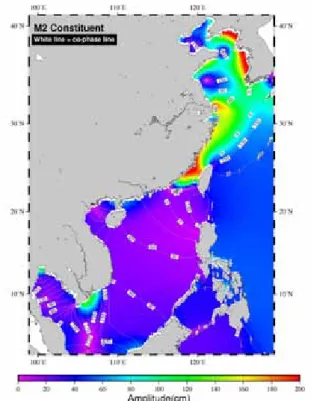
Fig. 3 shows the co-tidal chart of the simulated M2 tide, for example. In the northern Asian marginal seas, two distinct amphidromes appear in the Yellow Sea and two amphidromes degenerated to shore present in the Bohi Sea; their locations are the same as those appeared in the figure 2 of Kuo and Yanagi (1998) and the figure 8 of Lefevre et al. (2000). In the South China Sea, two amphidromes appear in the Gulf of
Thailand and a meridional nodal band presents over the Sunda Shelf, which is consistent with the ones that appeared in the figure 3 of Fang et al. (1999). The amplitudes of the simulated M2 tide are relatively large (> 2 m) off the west coast of Korea, north of the Yangtze River mouth and along the southeast coast of China. In comparison, the amplitudes are small in the SCS except for those off southeastern Vietnam and northwest coast of Borneo. The root mean squared error of the
model-data misfit is 0.123 m when averaged over the eighteen tide-gauge stations in Figure 2. For comparison, the model-data misfit for M2 tide is 0.158 m in Lefevre’s finely tuned East China Sea tidal model. Simulations of other principal constituents, O1, K1, N2 and S2, also agree with the observations. The model results will be used as the open boundary conditions of the TSSNOW model.
Fig. 3 Co-tidal chart (amplitudes/phases) of simulated M2 tide.
Circulation model
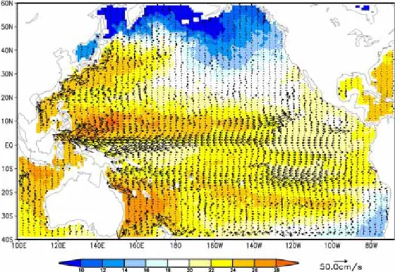
The three-dimensional Pacific circulation model is also revised from the Princeton Ocean Model (Blumberg and Mellor, 1987). The model domain is set between 40°S and 60°N parallels and 100°E and 70°W meridians with one degree of horizontal resolution and 21 sigma layers in the vertical. The model was driven by the yearly climatological forcing compiled in the World Ocean Atlas 2001. The horizontal eddy viscosity is set 1000 m2/s and the bottom drag coefficient is chosen as 0.0025. A control run of 10 years was achieved in a PC with two Itanium 2 processors. Fig. 4 illustrates the simulated currents averaged over the surface layer (depth > -50 m).
Major circulation patterns, such as the Equatorial current, the Equatorial counter current and the Kuroshio in the North Pacific, were successfully produced. The model results will be nested to a intermediate regional model of 1°/8 horizontal resolution and subsequently nested to the TSSNOW model. The coupling of tidal forcing and mean current for the smaller domain model will be carried out in the next phase.
Fig. 4 Pacific Ocean model simulated surface current (depth averaged over depth -50 m).
Summary
This report describes the progress of TSSNOW in 2003. We have developed two models for tidal sea level and temperature and salinity boundary conditions of the smaller domain, higher resolution TSSNOW model. The 1°/8 tide model was calibrated to the accuracy fitting the request of the TSSNOW model. The 1°
circulation model was driven to a quasi-steady state for further use. In the next stage, tidal sea levels and hydrographic parameters simulated from the two models will be coupled for the boundary conditions of the TSSNOW model.
References
Blumberg, A. F., and G. L. Mellor (1987) A description of a three-dimensional coastal ocean circulation model, in Three-Dimensional Coastal Ocean Models, edited by N. S. Heaps, pp.1-16, American Geophysical Union
Fang, G., Y.-K. Kwok, K. Yu ,and Y. Zhu (1999) Numerical simulation of principal tidal constituents in the South China Sea, Gulf of Tonkin and Gulf of Thailand,
Cont. Shelf Res., 19, 845-869
Jan, S., Y.-H. Wang, S.-Y. Chao and D.-P. Wang (2001) Development of a nowcast system for the Taiwan Strait (TSNOW). Ocean and Polar Research, 23, 2, 195-203
Jan, S., J. Wang, C.-S. Chern and S.-Y. Chao (2002a) Seasonal variation of the circulation in the Taiwan Strait, Journal of Marine Systems, 35, 3-4, 249-268 Jan, S., C.-S. Chern, and J. Wang (2002b) Transition of tidal waves from the East to
South China Seas over the Taiwan Strait: Influence of the abrupt step in the topography. Journal of Oceanography, 58, 6, 837-850
Jan, S. and S.-Y. Chao (2003a) Seasonal variation of volume transport in the major inflow region of the Taiwan Strait: The Penghu Channel, Deep Sea Research II, 50, 6-7, 1117-1126
Jan, S., Y.-H. Wang, D.-P. Wang, and S.-Y. Chao (2003b) Incremental influence of boundary forcing for a three-dimensional tidal model: Tides in the Taiwan Strait. Continental Shelf Research, in review
Palma, E. D. and R. P. Matano (2000) On the implementation of open boundary conditions for a general circulation model: The three-dimensional case. Journal of Geophysical Research, 105, C4, 8605-8627
Perkins, A. L., L. F. Smedstad, D. W. Blake, G. W. Heburn, and A. J. Wallcraft (1997) A new nested boundary condition for a primitive equation ocean model. Journal of Geophysical Research, 102, C2, 3483-3500
Wang, Y.-H., S. Jan and D.-P. Wang (2003) Transports and tidal current estimates in the Taiwan Strait from shipboard ADCP observations (1999–2001). Estuarine, Coastal and Shelf Sciences, 57, 195-201, doi:10.1016/S0272-7714(02)00344-X Kantha, L. H., Barotropic tides in the global oceans from a nonlinear tidal model
assimilating altimetric tides, Part I: Model description and results, J. of Geophys. Res., 100, 25283-25308, 1995.
Lefevre, F., C. Le Provost, and F. H. Lyard, How can we improve a global ocean tide model at a regional scale? A test on the Yellow Sea and the East China Sea, J. of Geophys. Res., 105, C4, 8707-8725, 2000.
National Geographic Data Center, ETOPO5: Bathymetry/Topography Data, U.S. Department of Commerce, Washington, D.C., 1987.
Orlanski, I., A simple boundary condition for unbounded hyperbolic flows, J. of Comp. Physics, 21, 251-269, 1976.
3. 沉積物通量實驗室
國科會於過去十多年來在東海 KEEP 計畫執行期間,大力支持沉積物收集 器(sediment trap)的採購和使用,已在中山大學海洋地質及化學研究所鍾玉嘉 教授實驗室建立良好的佈放和回收技術,且有豐碩的研究成果發表。國家海洋科 學研究中心有鑑於沉積物收集器為目前唯一可直接時序性採集海洋中沉降顆粒 和量測其通量的工具,且近幾十年來已普遍並成功地應用於海洋生地化的研究 上,為了推展沉積物收集器,使其普遍為國內有興趣的海洋學者使用,海科中心 特於民國八十九年在中山大學海洋科學院成立「國家海洋科學研究中心—高雄實 驗站」,將沉積物收集器納入中心的服務項目,提供海洋學界沉積物收集器的採 樣服務。沉積物收集器可同時提供淺、中和深層水柱中顆粒生地化作用的時序變 化資料,對海洋生地化作用的研究有相當重要的貢獻,是一般科學研究學者極有 興趣的材料。本計畫執行重點為統籌收集器佈放之相關資源和錨碇所需之技術之 諮詢與支援,同時負責保管並對學界開放所取得的收集器樣品,使樣品可做最有 效的應用,且經不同領域的學者分析各種參數後,可整合得到較全面的資料,對 提升國內海洋研究水準有實質的幫助。民國九十二年「國家海洋科研究中心」將 「高雄實驗站」予以重組,提升原「高雄實驗站」為「高雄分部」。「高雄分部」 之組織架構主要包含了三個子計畫:(1)「台灣海域短期預報系統」計畫;(2) 「沉積物收集器之佈放、回收及相關服務」計畫及(3)「海研三號貴重儀器使用 中心經費」計畫。「高雄分部-沉積物通量實驗室」服務人力目前除了總計畫主 持人許德惇教授外,另有協助計劃指導老師林慧玲教授,並聘有博士後研究一員 (洪國瑋博士)、錨碇技術員(郭芳旭)一名及碩士級研究助理一名(陳建興)。 「高雄分部-沉積物通量實驗室」除了負責收集器錨碇系統施放與回收作業、錨 碇設備之維修與校正工作之外,並協助收集之沉積物樣品的前處理分樣工作等。 其服務人力除了目前現有人員之外,本計畫擬增設一名碩士級研究助理,來協助 沉積物樣品的處理,主要工作為沉積物收集器樣品之分樣工作及挑除收集杯中 「非被動式沉降的顆粒」(swimmer)的工作。
(2) 本實驗室之執行成果
「高雄分部」運作計畫執行至今,主要是配合南海的 SIBEXS 和 SEATS 計畫以及高屏峽谷的“Land-sea sediment exchange through Kao-ping Submarine Canyon:its role and dynamic processes” 計畫進行沉積物收集器的採樣作業。由 2000 年底正式運作至今,於南海五個站位共施放了 11 串收集器串列及於高屏 峽谷內同一站位共施放了五串列,串列站位與採樣時間等資料表列於附表一, 測站位置如附圖一。另外將各測站收集器串列的採樣時間彙整繪製成圖二,以 利參閱。 在高屏峽谷區域除第一次施放的 T1kp 及第四次的 T4kp 兩串列成功回收 外,其餘兩串列 T2kp 和 T3kp 串列皆失敗,所以在高屏峽谷的回收率約有 60%。 同時由打撈回來的串列零件判斷,可能是測站位於漁船作業頻繁的區域,漁民 作業時拖網勾到錨碇串列,以致漁民憤而將串列惡意破壞的可能性極高,高屏 峽谷應屬串列施放的危險區域,再次佈放時須要審慎評估。 同時在南海截至目前為止,已成功地完成在 M1 及 KK 站的三串列以及 M2、M3 站各兩串列,各站的串列編號依佈放次序分別為 SCS-M1、SCS-M1S 與 SCS-M1T ,SCS-M2 與 SCS-M2S,SCS-M3 與 SCS-M3S,及 SCS-KK1 、 SCS-KK2 與 SCS-KK3 (KK 站為 SEATS 的連續觀測點),另於 M4 站施放一 串列,串列編號 SCS-M4。其中除 SCS-KK1 串列遺失以及 SCS-KK3 仍在 SEATS 站位(預計 2005 年 3 月初回收)之外,其餘串列皆已回收,並採得南海淺、 中和深層水體中的沉降顆粒樣品及流況資料。 「高雄分部」由南海與高屏峽谷所採集之收集器樣品,皆依樣品量的多寡 使用分樣儀(dispenser)將其等分為數份子樣品,再提供學界申請分析進行相關研 究,附表二所列即為至目前為止已申請並取得樣品之學者及其研究項目;利用 沉積物樣品而完成之學生論文及相關工作成果如附錄所列。 「海科中心-高雄分部」除了提供學界沉積物樣品的服務外,中心的儀器設 備在不影響收集器之佈放與回收的運作前提下,亦提供了研究設備及人員的支
援,出借記錄如附表三所列,其中「申請單位」所借用的設備主要以感音釋放 儀(Acoustic Release)與命令釋放儀(Telecommander Release)這兩項設備最 為頻繁。另外「海科中心-高雄分部」亦有沉積物收集器錨碇串列的佈放服務, 依據申請者研究區域及科學目的之需求—以及考量研究區域實際可行的佈放情 況而提供沉積物收集器串列的佈放服務。 沉積物通量實驗室持續進行中的工作項目及預期完成之目標如下: a、沉降顆粒通量和流場資料之量測—沉積物收集器和水流儀之時序錨碇。 b、佈放地點的流場與沉降顆粒通量時序變化之關係。 c、錨碇處岩心沉積物含量的放射性核種(210Pb-210 及230Th)量測。 d、收集器中沉降顆粒的有機碳、氮含量的測定 e、收集國內外相關之參考文獻與研究成果及藉由與國內、外錨碇專家的交流, 改良錨碇系統的設計與串列施放技術,提高收集器樣品收集的成功率,並 減少串列施放前與回收時的工作量。 (3) 可能遭遇之困難及解決途徑 「高雄分部-沉積物通量實驗室」負責沈積器串列的錨碇採樣服務,但博士 後研究洪國瑋在 2004 年 9 月出國進行一年的短期進修,實驗室運作明顯有人力 不足處,則以工讀生以工時計補充來補足。「沉積物通量實驗室」目前作業瓶頸 在於分樣工作與沉積物樣品中挑除”swimmer”的和洗鹽與乾燥等後續處理工 作,為求實驗品質的穩定性與一致性以及作業流程的通暢,希望增加一名專任助 理來專責完成上述的樣品後續處理工作,以及期望提高「高雄實驗站」的運作效 率、並提供學界更好的服務。 此外,由於各保險公司近來不斷提高錨碇串列之保費,92 年度的儀器保險 費更高達儀器總值的 57%。在此情況之下,巨額的儀器保險費已非計畫所編列之 保費所能負擔,故 92 年度所有錨碇串列上之儀器皆未辦理保險,而其所編列之
保險費已申請變更為「研究設備費」,用以購買備用儀器,以免錨碇串列因故遺 失時,在無備用儀器的情況下,影響了計畫的執行。至 93 年度,儀器保險費降 至 40%左右,為求保險起見,且若因新購置儀器設備尚未至使用年限而遺失, 則將無法回復「審計部」之審查責任,所以,幾經考量、運算之後,擬將 1/3 的 儀器、設備投保,可將有投保的儀器設備佈放於較易遭受破壞(或危險)之區域, 如此一來,兼顧了高危險海域遺失儀器的風險,另一方面節省了部分高保險費的 支出,將省下的保險費可編列為需汰舊換新的儀器設備費,以及購買需增購的設 備。 (4) Summary 從 92 年 8 月 1 日至 93 年 12 月 31 日,沉積物通量實驗室所執行並完成的工 作如下: 1. 92 年 8 月 9 日於海研三號 894 航次回收南海錨碇串 SCS-M3S。 2. 92 年 11 月 5 日於海研三號 916 航次回收南海錨碇串 SCS-M4。 3. 92 年 12 月 12 日於海研一號 705 航次回收南海錨碇串 SCS-M3S。 4. 93 年 5 月 25 日於海研三號 969 航次佈放高屏峽谷 2 組錨碇串 T4KP-L 及 T4KP-S。 5. 93 年 6 月 27 日於海研三號 981 航次回收高屏峽谷 2 組錨碇串 T4KP-L 及 T4KP-S。 6. 93 年 11 月 5 日於海研一號 736 航次回收南海錨碇串 SCS-M1T。 (以上資料可參閱附表一及圖一) 從 92 年 8 月 1 日至目前,沉積物通量實驗室進行錨碇串列的佈放與回收還 算順利,皆能成功地完成。而樣品的處理與分析工作仍持續進行中,只是人力的 部分稍有不足,以致於回收後的樣品後續處理工作有所延宕,無法滿足標本申請 人在時效上的要求。
附表一、(1) 高屏峽谷沉積物收集器串列基本資料 串列名稱 串列相關資料 T1KP (三號 634 航次) T4KP-L (三號 969 航次) T4KP-S (三號 969 航次) 位置: 22 o 24.782’N, 120o23.739’E 22o24.249’N, 120o24.077’E 22o24.278’N, 120o23.963’E 水深: 291m 323m 315m 收集杯收集天數 2.5 天 2.5 天 2.5 天 起始收集日期 06/20/2000 14:00 05/26/2004 0:00 05/26/2004 0:00 各收集器施放深度 181m 231m 58m 285.3m (2) 高屏峽谷及南海沉積物收集器串列佈放失敗之基本資料 串列名稱 串列相關資料 T2kp(三號 683 航次) SCS-KK1(一號 656 航次) T3kp(三號 792 航次) 佈放時間 03/08/2001 02/11/2002 06/27/2002
(3) 南海沉積物收集器串列基本資料 串列名稱 串列相關資料 SCS-M1 (三號 668 航次) SCS-M2 (一號 597 航次) SCS-M1S (三號 727 航次) 位置 21 o 31.715’N, 119o27.906’E 19o01.04’N, 117o31.495’E 21o30.861’N, 119o27.873’E 水深 2948 m 3740 m 2943m 收集杯收集天數 15 天 15 天 15 天 起始收集日期 12/11/2000 0:00 10/14/2000 0:00 09/22/2001 0:00 施放深度 248 m 948 m 1948 m 2848 m 240 m 1240 m 2240 m 3240 m 374 m 925 m 1925 m 2702 m 串列名稱 串列相關資料 SCS-M2S (一號 632 航次) SCS-M3 (三號 782 航次) SCS-M3S (三號 859 航次) 位置: 19 o 00.010’N, 117o29.502’E 20o17.266’N, 118o14.046’E 20o18.312’N, 118o14.240’E 水深: 3743m 2626m 2500m 收集杯收集天數 15 天 15 天 15 天(改用滷水) 起始收集日期 12/16/2001 0:00 05/24/2002 0:00 04/15/2003 0:00 施放深度 447 m 1248 m 2249 m 3250 m 597m 1126m 1726m 2326m 434m 963m 1563m 2163m 串列名稱 串列相關資料 SCS-KK2 (三號 859 航次) SCS-M4 (三號 903 航次) SCS-M1T (三號 958 航次) 位置: 18 o 21.583’N, 115o20.528’E 21o00.722’N, 118o12.562’E 21o31.728’N, 119o27.186’E 水深: 3820m 2217m 2950m 收集杯收集天數 7.5 天(改用滷水) 1.5 天(改用滷水) 15 天(改用滷水) 起始收集日期 04/15/2003 0:00 09/27/2003 0:00 05/01/2004 0:00 施放深度 320m 1020m 3520m 623m 1740m 524.6m 964.1m 1964.4m 2842.7m
附表二、申請沉積物樣品之使用者與申請之分析項目等 使用者 單位 採樣海域 申請樣品 分析項目 李玉玲 中山大學 海資系 南海 東海 KK2,24 個樣品 SCS-M1S、M2S 及 M3 等 42 個樣品 M1T,22 個樣品 T1,2 個樣品 T3,2 個樣品 分析沉積物樣品之δ15 N. 鏡檢沉積物浮游植物藻相. 比較東海與南海海域固氮作用之新生產力對碳向下輸送之差異. 李宗霖 中山大學 海工系 高屏海域 T4kp,24 個樣品 顆粒中之多環芳香含量分析. 林慧玲 中山大學 海地化所 南海 SCS-M1S、M2S 及 M3 有孔蟲殼體穩定同位素分析 洪佳章 中山大學 海地化所 高屏海域 南海 T4kp,24 個樣品 SCS-M1S、M2S 及 M3 等 90 個樣品 瞭解高屏峽谷生源與陸源物質之源與匯. 分析樣品中之有機碳、氮、磷、opal 及鋁等. 曾鈞懋 海科中心 南海 KK2,24 個樣品 分析沉積物/沉降顆粒之金屬元素. 游鎮烽 成大地科系 南海 SCS-M1S、M2S 及 M3 有孔蟲殼體微量元素分析 劉祖乾 中山大學 海地化所 高屏峽谷 T4kp,24 個樣品 峽谷顆粒動力研究. 劉康克 高樹基 中央大學 水文所 中研院 南海 SCS-M1S、M2S 等 75 個樣品 分析沉積物樣品之δ15 N. 鍾玉嘉 中山大學 海地化所 南海北部 M1S,46 個樣品 M1S,23 個樣品 放射性同位素地球化學研究.
附表三 海科中心-高雄分部提供設備及人員之支援 申請人 申請單位 借用設備(人員支援) 借用之計畫名稱 借用時間 王兆章 海下所 Telecommander Release(MORS,TT301) Acoustic Release(MORS,AR661CS) 海下所海上實習 2004.12.12~2004.12.18 曾若玄 海資系 Telecommander Release(MORS,TT301) Acoustic Release(MORS,AR661CS) 澎湖水道的底床邊界層混合 的特性(NSC) 2004.6.4~2004.7.31 王玉懷 海物所 Acoustic Release(MORS,AR661CS) 廢火車輪(已購買歸還) 火車輪座(已購買歸還) FATES(NSC) 2004.12.12~2004.12.30 陳信宏 海下所 Telecommander Release(MORS,TT301)、 Commander 浮筒(76kg)乙組、Shackle 五只、5M 尼龍 纜乙條 海下所海上實習 2004.12.28~ 2004.1.4 陳信宏 海下所 打撈儀器(人員支援) 海下所海上實習 2005.1.17~2005.1.19
附錄: 使用沉積物樣本的研究工作成果 呂佳珍,2004,南海北部晚第四紀多種屬有孔蟲碳氧同位素地層及古海洋變遷, 中山大學海洋地質及化學研究所碩士論文,90 頁。 王薇喬,2003,高屏峽谷與南海北部沉積物收集器的有孔蟲組合及其穩定同位素 之季節性變化,中山大學海洋地質及化學研究所碩士論文,98 頁。 張慧貞,2002,南海北部海域之沉降顆粒及沉積物:顆粒通量舉鉛-210 之分佈, 中山大學海洋地質及化學研究所碩士論文,64 頁。 黃俊傑,2001,從高屏峽谷水文之時空變化來探討懸浮物質傳輸的機制,中山大 學海洋資源研究所碩士論文,101 頁。
Chung, Y., H. C. Chang and G. W. Hung, 2004, Particulate flux and 210Pb dtermined on the sediment trap and core samples from the northern South China Sea. Cont. Shelf Res., 24, 673-691.
Lin H.-L., W.-C. Wang, G.-W. Hung and Y.-J. Hsieh, 2004, Seasonal variation of
planktonic foraminiferal isotopic composition from the sediment traps in the South China Sea. Mar. Micropaleontology.
Lin H.-L., J. T. Liu and G.-W. Hung, 2004, Benthic foraminiferal shells in sediment traps:implications of biogenic particle transport in the Kao-ping Submarine Canyon. Cont. Shelf Res. (submitted)
Chen-Lee, Y. L., H. Y. Chen, Y. H. Lin. 2003, Distribution and downward flux of Trichodesmium in the South China Sea as influenced by the transport from the Kuroshio Current. Marine Ecology Progress Series, 259, 47~57.
Liu, J. T., Hsu, R. T., Huang, J.-S. and Chao, S.-Y., 2002/3, Sediment dispersal pattern of an eroding delta on the west coast of Taiwan. In: Tropical Deltas of Southeast Asia- Sedimentology, Stratigraphy, and Petroleum Geology, Sidi, F. H., Nummedal, D., Imbert, P., Darman, H. and Posamentier, H. W., (eds.), SEPM Special
Publication #72 (in press).