Geophys. J. Int. (2008) 172, 1049–1054 doi: 10.1111/j.1365-246X.2007.03686.x
GJI
Seismology
New seismogenic source and deep structures revealed by the 1999
Chia-yi earthquake sequence in southwestern Taiwan
Yue-Gau Chen,
1Yu-Ting Kuo,
1Yih-Min Wu,
1Hsiung-Lin Chen,
1Chien-Hsin Chang,
2Ron-Yu Chen,
2Po-Wen Lo,
1Kuo-En Ching
3and Jian-Cheng Lee
41Department of Geosciences, National Taiwan University, No. 1, Section 4th, Roosevelt Road, Taipei 106, Taiwan. E-mail: [email protected]
2Central Weather Bureau, Taipei 100, Taiwan
3Department of Earth Sciences, National Cheng-Kun University, Tainan 701, Taiwan 4Institute of Earth Sciences, Academia Sinica, Taipei 115, Taiwan
Accepted 2007 November 8. Received 2007 November 8; in original form 2006 June 29
S U M M A R Y
In a tectonically active setting large earthquakes are always threats; however, they may also be useful in elucidating the subsurface geology. Instrumentally recorded seismicity is, therefore, widely utilized to extend our knowledge into the deeper crust, especially where basement is involved. It is because the earthquakes are triggered by underground stress changes that usually corresponding to the framework of geological structures. Hidden faults, therefore, can be recognized and their extension as well as orientation can be estimated. Both above are of relevance for assessment on seismic hazard of a region, since the active faults are supposed to be re-activated and cause large earthquakes. In this study, we analysed the 1999 October 22 earthquake sequence that occurred in southwestern Taiwan. Two major seismicity clusters were identified with spatial distribution between depths of 10 and 16 km. One cluster is nearly vertical and striking 032◦, corresponding to the strike-slip Meishan fault (MSF) that generated the 1906 surface rupture. Another cluster strikes 190◦ and dips 64◦ to the west, which is interpreted as west-vergent reverse fault, in contrast to previous expectation of east vergence. Our analysis of the focal solutions of all the larger earthquakes in the 1999 sequence with the 3-D distribution of all the earthquakes over the period 1990–2004 allows us reinterpret the structural framework and suggest previously unreognized seismogenic sources in this area. We accordingly suggest: (1) multiple detachment faults are present in southwestern Taiwan coastal plain and (2) additional seismogenic sources consist of tear faults and backthrust faults in addition to sources associated with west-vergent fold-and-thrust belt.
Key words: Seismicity and tectonics; Continental margins: convergent; Neotectonics; Kinematics of crustal and mantle deformation; Crustal structure.
I N T R O D U C T I O N
Modern tectonic environment of Taiwan
It is well known that Taiwan is seismically active since it is located in a setting of arc-continent collision (Tsai et al. 1977; Wu 1978). This collision is produced by the interaction of two arc-trench systems with flipped subduction polarities (inset of Fig. 1; Suppe 1981; Ho 1986; Teng 1990). The southern system (i.e. the Manila trench and Luzon arc) is characterized by that oceanic crust of South China Sea eastward underplating the Philippine Sea plate to form the overlying Luzon volcanic arc. Since Philippine Sea plate moves northwest-ward and subducts underneath Eurasian plate to create the northern system (i.e. the Ryukyu trench and arc), the Luzon arc must collide with the continental margin. In response to this collision, mountain ranges are plowed upwards from the sea bottom and subsequently
emerge as the island of Taiwan. Here, the critical wedge theory has been structurally proposed to explain the growth of Taiwan fold-and thrust belt (Davis et al. 1983). In this context, the modern western foreland is situated in the deformation front, but sooner or later will be involved into the belt once the basal detachment migrates over. Since this plain area is highly populated, identifying the seismo-genic sources that produce large magnitude earthquakes is critical. Undoubtedly the major N–S thrust systems of western Taiwan and their subsidiary tear faults are the large seismic sources. Are there other unknown sources? In this study, we take the advantage of a recent 1999 Mw6.4 Chia-yi earthquake to analyse structure-linked
sources and their related structures in additional to that predicted by simple critical wedge theory (Suppe 1981; Davis et al. 1983), which is mainly composed of thrust faults with normal vergence (i.e. consistent with the developing direction of the fold-and-thrust belt).
Figure 1. (a) Inset in the upper left-hand corner shows the tectonic setting of Taiwan (after Ho 1986; Angilier 1986). (b) Geological map of the study area,
which is situated in the mountain front of the fold-and-thrust belt of Taiwan. Grey circles are GPS stations and blue arrows are velocity vectors from 1993 to 1999 (Hsu et al. 2003). Thin dashed lines are the surface projections of the pre-existing normal faults found in depth by seismic exploration (CPC 1982).
Thick dashed line marks location of topographic profile shown in inset (c). (c) The upper panel is topographic profile across Taiwan along orientation of 306◦.
The lower panel is the profile showing the horizontal velocity field derived by GPS observation (Hsu et al. 2003). Solid lines mark the locations of TCSF and Longitudinal Valley Fault (LVF).
Chia-yi—an active seismic setting
In the wake of two disastrous earthquakes in the Chia-yi region of southwestern Taiwan—the 1906 Meishan (ML7.1) and 1941 Chungpu (ML7.1) events—scientists have long sought to under-stand the seismogenic sources in Chia-yi. This densely populated region is located immediately in the front of the Taiwan fold-and-thrust belt (Fig. 1). In addition to the Meishan fault (MSF in Fig. 1), two N–S trending and west vergent active thrusts, the Chiuchiungkeng (CCKF) and Tachienshan (TCSF) faults, are lo-cated to the east (Chang et al. 1998; Lin et al. 2000), and these were thought to be major seismogenic sources. Based on the 1:100 000 geological map of Chia-yi, published by the Chinese Petroleum Company (CPC 1982), the Mio- to Pliocene strata have been uplifted to the west by the thrust fault, TCSF (Fig. 1). Later, the Plio- to Pleistocene strata have been faulted by the western frontal thrust, CCKF. Both the TCSF and CCKF have estimated strike lengths of over 30 km. Based on simple scaling relations, a strike length of 30 km might generate earthquakes of magnitude 7 or greater, but only if the locking depth is more than a few kilometres and the entire fault-plane ruptures as a unit.
Considerable evidence supporting recent activity along the TCSF and CCKF has been presented previously (Wu 1978; Huang et al. 1994; Chen 1999; Lin et al. 2005); however, the geomorphic evi-dence suggests that the TCSF is less active than CCKF (Hsieh & Knuepfer 2002; Shyu et al. 2005). Although no specific thrust fault
to the west of CCKF has been clearly defined, the well-developed Hsiaomei Anticline (HMA, Fig. 1), located in the footwall of the CCKF, was interpreted as a detachment fold (Suppe 1976), imply-ing that the basal decollement has migrated westward. Moreover, geodetic and geomorphic evidence both support this point of view (Angilier & Chen 2002; Hsu et al. 2003; Shyu et al. 2005; Yang et al. 2005). Within the study area, GPS-measured ground velocities de-crease from the mountain belt to a region 15 km west of the CCKF. Based on the dislocation model (Hsu et al. 2003) and mountain building theory (i.e. critical wedge mechanics; Davis et al. 1983), this implies that the decollement has extended far westward over the CCKF (Blue arrows in Fig. 1). On the other hand, late Pleistocene terraces and alluvial surfaces in the footwall of CCKF are reported as being uplifted and folded (Angilier & Chen 2002; Shyu et al. 2005; Yang et al. 2005). Since the terrace deposits are about 38 ka (Chen et al. 2006), this age suggests that the thrust front has been active near the city of Chia-yi (Fig. 1) for at least a few tens of thousand years. On the basis of the cumulative deformation derived from the geomorphic surfaces, it appears that other active faults in addition to TCSF, CCKF and MSF are needed to accommodate the total strain (Yang et al. 2005). Thus, other unknown seismogenic sources besides the three mapped faults are hypothesized to be as-sociated with the developing thrust tip under the coastal plain. The 1999 Mw6.4 earthquake sequence is right located under this plain area. It may help us locate unknown seismogenic source and further revise the structural framework for the Chia-yi region (Figs 1 and 2).
New seismogenic source and deep structures revealed 1051
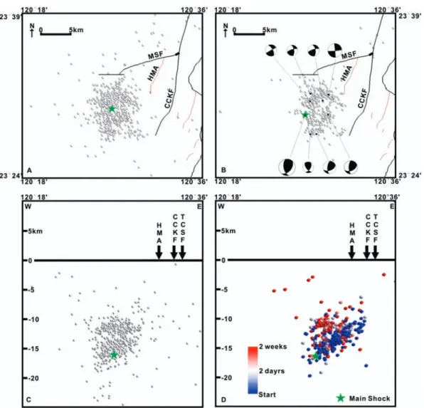
Figure 2. (a) Epicentre distribution of the 1999 Chia-yi earthquake sequence. (b) Relocated distribution after double-difference algorithm with focal mechanisms
of larger earthquakes. (c) E–W profile showing the hypocentre distribution in depth. (d) Profile showing relocated hypocentres. Colour (blue-white-red) indicates that the triggered aftershocks on the backthrust occurred earlier than the other earthquakes.
1999 Mw= 6.4 Chia-yi earthquake
After the 1906 and 1941 events the study area did not experience large earthquakes until the 1998 Rueili and 1999 Chia-yi earth-quakes. The 1999 October 22 Chia-yi earthquake (Mw6.4) occurred one month after the disastrous 1999 Mw7.3 Chi-chi earthquake (Ma et al. 1999). The epicentre of the Chia-yi main shock was located 2 km northwest of the city of Chia-yi with a focal depth of 12 km, according to the rapid report of the Central Weather Bureau (CWB) of Taiwan (Fig. 1), and it was followed by a series of aftershocks over 2 weeks (Fig. 2). The epicentres of the entire sequence were bounded by the CCKF and MSF in the east and north, respectively (Fig. 2). Before source inversion and spatial analysis of the sequence, many scientists considered this sequence as evidence for the frontal blind-thrust mentioned above. Surprisingly, the waveform inversion indicated a rupture along a thrust with east-vergence instead of the expected west-vergence (Ma & Wu 2001). We therefore, took the opportunity to re-evaluate the 3-D distribution of all the earthquakes, including the background ones, over the period 1990–2004. We also analysed the focal solutions of all the larger earthquakes in the 1999 sequence with the aim of understanding the behaviour of the rel-evant seismogenic structures. Finally, we synthesized a structural model down to the depth level of the main shock.
D AT A A N A LY S I S A N D R E S U L T Conducted databases
Two seismic data sets were separately processed in our study: the 1999 Chia-yi earthquake sequence and background seismic-ity recorded in the catalogue of Central Weather Bureau, Taiwan. Both of them are records from Central Weather Bureau Seismic Network (CWBSN) and consist of 74 seismic stations distributed all around Taiwan (Shin & Teng 2001). Near Chia-yi, there are 22 stations evenly distributed in an area of 10 000 km2. The study pe-riod for the 1999 Chia-yi sequence is defined as the duration from the main shock GMT 02:18 of October 22 to 22:19 of November 4; all processed earthquakes in our study are clearly detected at least by four stations. Before visually identifying the 3-D distribution of the earthquakes, two steps are applied to relocate the hypocentres. The first step is the 3-D COR (Wu et al. 2003, 2006a,b and the second is the double-difference algorithm (Waldhauser & Ellsworth 2000). Both of the methods have been successfully tested in Tai-wan. During our computation, the algorithm of L2 norms is adopted to evaluate the errors. Our results show 421 qualified earthquakes in an area of 23.43◦N–23.63◦N and 120.30◦E–120.60◦E (Fig. 2). The smallest earthquake is ML1.4. The background seismicity was
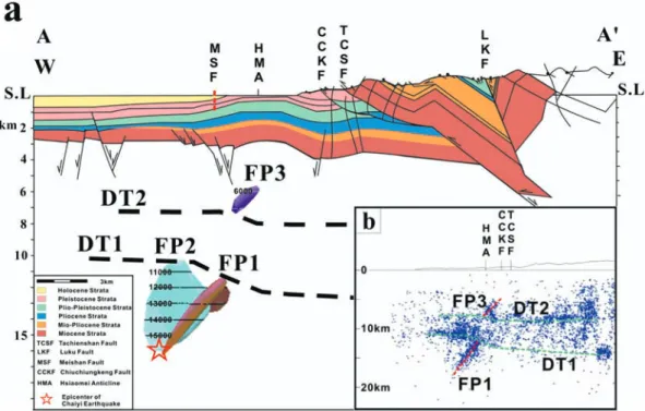
Figure 3. (a) Upper crust geological structures reconstructed by the surface and subsurface geology (CPC 1982; Yang et al. 2001). Also shown are the fault
planes (FP1, FP2 and FP3, DT1 and DT2) identified by seismicity distribution in the study area. Stratigraphic units correspond to Fig. 1. (b) E–W profile shows the relocated background events. FP1, FP3, DT1 and DT2 are identified as clusters.
selected from records between 1990 and 2004; we purposely omitted the relatively large earthquake sequence including the 1999 Chia-yi earthquake sequence. The area coverage is within a rectangular area of 23.40◦N–23.65◦N and 120.20◦E–120.70◦E and the selected earthquakes were recorded by at least six seismic stations. All the earthquakes are relocated by only double-difference algorithm. Af-ter the relocation process, 5455 earthquakes are left and the smallest earthquake is about ML1.15. The estimated error of the location is about 200 m, which is good enough to define the geometry of the seismicity clusters. The velocity model adopted in this study is from Shin & Ho (1994).
Fault planes derived by the seismicity
Our analysis of the 1999 Chia-yi sequence shows two distinct clus-ters, distributed in depth between 10 and 16 km (Fig. 2), indicating two fault planes, FP1and FP2 (Fig. 3). Their corresponding strike and dip are (190◦, 64◦) and (032◦, 90◦), respectively. Fig. 2(d) illus-trates the timing of the events, showing that the main shock triggered FP1 and FP2 in an orderly sequence. This is another example of how a main shock may transfer stress to neighbouring structures, trig-gering secondary earthquakes on them (e.g. Stein 1999; Lin & Stein 2004). Eight focal solutions, including the main shock and the larger aftershocks, were determined in order to examine the rupture sense (Fig. 2b). On each of the two fault planes the focal solutions of the larger earthquakes are quite consistent, showing that FP1 is a backthrust and FP2 a strike-slip fault (Fig. 2b).
In addition to FP1, our E–W profile of background seismicity suggests the presence of two detachments, DT1 and DT2, and one more fault, FP3 (Fig. 3b). The DT2 is clearly identified by the clus-tered seismicities, appearing between the depths of 8–9 km. The fault plane FP3 roots on the DT2 and dips westward, probably indi-cating another backthrust originating from the bend on the DT2. In
order to identify the DT1 located in the west of FP1 we used similar criteria as above; however, to the east of FP1 the seismic cluster is diffuse. Therefore, we analysed the interface of upper-seismic zone and lower aseismic zone, since the detachment probably de-velop along the base of stronger competent rock unit. This suggests a bend existing in detachment DT1 right above the FP1 (Fig. 3b, see the lower green dashed line). Here FP1 displaces crystalline rocks in the hanging wall upward into shallower and cooler crustal levels. The rock competence may be stronger in the west to cause more seismicity relatively to the east of FP1. It also worthwhile to note that the FP1 and FP3 are two separated backthrust faults.
D I S C U S S I O N
1. What is the origin of the lower backthrust (FP1)?
Based on the temporal and spatial relationship between the main shock and the aftershocks, FP1 appears to extend upwards from a depth of 16 km. This indicates that the crustal contraction from the tectonic collision influences the deep crust beneath the decollement that is hypothesized to horizontally separate the deformed upper crust from the deeper-lying undeformed crust (Suppe 1981; Davis et al. 1983). Two mechanisms are suggested for the generation of FP1. The first mechanism is that for certain rheological reasons the ductile lower crust moves westward and upward from a depth greater than 16 km. At a shallower depth (<16 km) the deforma-tion becomes concentrated along a pre-existing fault trace, most likely along a normal fault that developed before collision. An-other possibility is that a deeper detachment-like interface located below DT1 (Fig. 4) is present but could not be identified seismo-logically due to methodology limitations. It is probably because of the pre-existing fault system mentioned above; a bend exists on this tentatively hypothesized deeper interface. In response to the bend, a wedge backthrust is generated from there (e.g. FP1; Fig. 4). Such a
New seismogenic source and deep structures revealed 1053
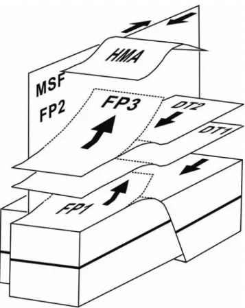
Figure 4. Block model of the study area. Herein, the MSF is a tear-fault that
is coupled with FP3. The HMA has developed in response to the backthrust FP3. FP1 generated the 1999 earthquake. The bend on DT2 was created by the bend on DT1, which is created by action of FP1.
structural complexity may facilitate stress accumulation and cause large earthquakes such as the 1999 Chia-yi earthquake. So far we have not been able to identify such a deep interface. A dense seis-mometer network capable of detecting microearthquakes is needed to resolve this puzzle.
2. Lower backthrust (FP1) bends the upper detachments (DT1 and DT2)
Does FP1 emerge above DT1 and connect to FP3 (Figs 3 and 4)? The events distributed between DT1 and DT2 above FP1 are mostly related to the E–W trending FP2, located in the northern part of the study area (Fig. 3b). If events related to FP2 are removed, seismic clusters of FP1 and FP3 are not connected, although they both are backthrusts with similar orientation. Nevertheless, FP1 displaces the footwall upwards from the lower crust, producing a bend on DT1 (Figs 3 and 4). The DT1 bend will certainly affect the mass move-ment above DT1 and creates another bend on the upper detachmove-ment DT2. As a result, another backthrust, FP3, is generated from DT2 upwards (Figs 3 and 4). The HMA developed in the uppermost crust is probably a response to the FP3 mentioned above.
3. MSF is a deep tear fault
Since the Meishan fault truncates the Hsiaomei anticline, Shyu et al. (2005) suggested that the MSF represents a surface tear fault (Fig. 1). If the Meishan represents a tear fault, it must cut across the entire thrust sheet to the depth of the decollement (Hurtado Jr. et al. 2001). It is not clear if the fault extends to such a depth? The spa-tial relationships of the seismogenic clusters identified in the 1999 Chia-yi event (Fig. 2) suggest that the MSF extends to the depth of the detachment. Although FP1 and FP3 are backthrusts coupled above the deep detachments upward and eventually generating the
HMA near the surface, the seismicity clusters corresponding to FP1 and FP3 are both restricted to the south of FP2 (Fig. 2b). Based on a similar spatial orientation, we propose that the FP2 is the subsurface image of MSF. This implies that MSF is a major tear fault, separat-ing the thrust sheets from the surface to the deep crust at least over the lower detachment DT1 (Fig. 4). Considering the area of the fault plane, MSF could generate a large, disastrous earthquake such as 1906 event (ML7.1).
4. The role of pre-existing normal fault system
Prior to tectonic collision, Taiwan had been a passive margin for sev-eral tens of million years (Ho 1988). Numerous pre-existing normal faults were reactivated into compressional faults in the subsequent collisional fault-and-thrust belt. Presently, these pre-existing nor-mal faults preferentially accommodate the contraction along thrust faults rather than creating new faults. This was previously suggested elsewhere in Taiwan (Suppe 1986; Yang et al. 1996). We propose that the Chia-yi area is one of the examples. The pre-existing nor-mal faults are orientated E–W and are separately by N–S trending transfer-faults (please see thin dashed lines in the coastal area of Fig. 1). The orientations of MSF and FP2 match the pre-existing normal faults. In contrast, the development of FP1 and FP3 seems to have been controlled by pre-existing west-dipping transfer fault. The faults certainly would have significantly influenced the devel-opment of the new fault system in the newly arising stress field due to compressional tectonics (Figs 3 and 4).
5 Seismogenic sources in Chia-yi
Before the 1999 Chia-yi earthquake, the sources for large earth-quakes in the region were thought to consist only of one EW strike-slip fault (MSF) and two NS thrust faults (CCKF and TCSF). Our analysis of the 1999 event suggested additional earthquake sources. For example, the backthrust system (FP1 and FP3) and their re-lated detachment bends (on DT1 and DT2) are seismogenic sources within the entire fault network (Figs 3 and 4). Since these faults reactivate pre-existing faults, we suggest that other unrecognized sources could be identified if we could better constrain the sub-surface geology related to the upper thrust system and the buried pre-existing normal fault system. Such an improved understanding can be derived from the study of natural earthquakes or from new geophysical exploration. Lastly we would like to make a note on seismic hazard mitigation related to the large seismic sources. It is of great importance to constrain the numbers and locations of the large earthquakes when one considers the seismic hazard mit-igation. If large earthquakes are generated by west-vergent major thrust faults, the epicentres will be all located within the eastern hills. The 1999 Chia-yi earthquake reveals the epicentres of large earthquakes certainly have chance to be located in the western plain area, where is full urbanized and highly populated. In light of our study, hazard mitigation plan may need to be revised based on this newly proposed finding.
C O N C L U S I O N S
The 1999 Chia-yi earthquake allows re-evaluation of the structure framework and seismogenic sources for a place located in the west of Taiwan fold-and-thrust belt. Analysis of the 1999 Chia-yi earth-quake sequence yielded unrecognized seismogenic faults distributed in depths between 10 and 16 km are unveiled: FP1(190◦, 64◦) and FP2(032◦, 90◦). FP2 is perhaps the down dip continuation of the Meishan fault that produced the 1906 Mw 7.1 earthquake. This strike-slip fault acts as a tear fault and bounds the northern mar-gin of the region. FP1 is a backthrust and points to the complex
deformation front that consists of multiple detachments in the Chia-yi region. The proposed tear faults and backthrusts are controlled by the locations of the pre-existing normal fault system. In the last, additional large seismic sources should be considered for the hazard assessments.
A C K N O W L E D G M E N T S
We are grateful to editor, Dr T. Dahm, and two anonymous reviewers for their kind help and constructive comments. We also would like to thank Dr C. M. Rubin for his time and efforts in discussion and writing suggestions. This study was supported by the National Science Council (NSC) of Taiwan under grant numbers NSC 93-2119-M-002-026, and 94-2119-M-002-002. It is also supported by the Central Geological Survey of Taiwan and Taiwan Earthquake Research Center (TEC) funded through NSC. The TEC contribution number for this article is 00020.
R E F E R E N C E S
Angelier, J., 1986. Geodynamics of the Eurasia-Philippine sea plate bound-ary: preface, Tectonophysics, 125, ix–x.
Angelier, J. & Chen, R.F., 2002. Mathematical analysis of longitudinal river profiles reveals tectonic uplift: Hsiaomei, Taiwan, C. R. G´eosci., 333, 1103–1111.
Chang, H.C., Lin, C.W., Chen, M.M. & Lu, S.T., 1998. An Introduction to
the Active Faults of Taiwan: Explanatory Text of the Active Fault Map of Taiwan. Scale 1:500,000. Spec. Publ. of Cent. Geol. Surv. Taiwan 10,
103p. (in Chinese with English abstract).
Chen, R.F., 1999. Geomorphic index study of active structures in Chiayi-Tainan area, Southwestern Taiwan. Masters thesis. Department of Earth Sciences, National Cheng Kung University, Tainan, Taiwan R.O.C. Chen, W.S., Yeh, M.G., Yang, C.C., Shih, R.C., Lin C.W. & Hou, C.S., 2006.
Structural characteristics of the Meishan fault, Bull. Cent. Geol. Surv.
Taiwan, 19, 135–152 (in Chinese with English abstract).
CPC, 1982. The Geological Map of Chiyi, Scale 1: 100,000. Published by
Petroleum Exploration Division, Chinese Petroleum Corporation, Taiwan
R.O.C.
Davis, D., Suppe, J. & Dahlen, F.A., 1983. Mechanics of fold-and-thrust belts and accretionary wedges, J. Geophys. Res., 88, 1153– 1172.
Ho, C.S., 1986. A synthesis of the geologic evolution of Taiwan,
Tectono-physics, 125, 1–16.
Ho, C.S., 1988. An Introduction to the Geology of Taiwan: Explanatory
Text for The Geologic Map of Taiwan, 2nd edn, Scale 1:500,000,
Cen-tral Geological Survey, Ministry of Economic Affairs, Taiwan, R.O.C., 164p.
Hsieh, M.L. & Knuepfer, P.L.K., 2002. Synchroneity and morphology of Holocene river terraces in the southern Western Foothills, Taiwan: a guide to interpreting and correlating erosional river terraces across growing anticlines, Geomorphology, 38, 337–372.
Hsu, Y.J., Simons, M., Yu, S.B., Kuo, L.C. & Chen, H.Y., 2003. A two dimensional dislocation model for interseismic deformation of the Taiwan mountain belt, Earth planet. Sci. Lett., 211, 287–294.
Huang, C.S., Ho, H.C. & Liu, H.C., 1994. Geological investigation of the Chukou Fault, southern Taiwan, Bull. Cent. Geol. Surv. Taiwan, 9, 51–76 (in Chinese with English abstract).
Hurtado Jr., J.M., Hodges, K.V. & Whipple, K.X., 2001. Neotectonics of the Thakkhola graben and implications for recent activity on the South Tibetan fault system in the central Nepal Himalaya, Geol. Soc. Am. Bull.,
113, 222–240.
Lin, C.W., 2005. The Chiuchiungken Fault: a candidate to trigger a catas-trophic Earthquake in Western Taiwan, J. Asian Earth Sci., 30, 390–402 (doi: 10.1016/j.jseaes.2006.07.021).
Lin, J. & Stein, R.S., 2004. Stress triggering in thrust and subduction earthquakes, and stress interaction between the southern San Andreas and nearby thrust and strike-slip faults, J. Geophys. Res., 109, B02303, doi:10.1029/2003JB002607.
Lin, C.W., Chang, H.C., Lu, S.T., Shih, T.S. & Huang, W.J., 2000. An
In-troduction to the Active Faults of Taiwan: Explanatory Text of the Active Fault Map of Taiwan, 2nd edn, Scale 1:500,000, Spec. Publ. of Cent. Geol.
Surv. Taiwan 13, 122 p. (in Chinese with English abstract).
Ma, K.F. & Wu, S.I., 2001. Quick slip distribution determination of moderate to large inland earthquakes using near-source strong motion waveforms,
Earthq. Eng. Earthq. seism., 3, 1–10.
Ma, K.F., Lee, C.T., Tsai, Y.B., Shin, T.C. & Mori, J., 1999. The Chi-Chi, Taiwan earthquake: large surface displacements on an inland thrust fault,
EOS Trans. Am. Geophys. Union, 80, 605–611.
Shin, T.C. & Ho, M.Y., 1994. Three dimension velocity structure of western Taiwan, Meteo. Bull., 40, 216–234.
Shin, T.C. & Teng, T.L., 2001. An overview of the 1999 Chi-Chi, Taiwan, earthquake, Bull. seism. Soc. Am., 91(5), 895–913.
Shyu, J.B.H., Sieh, K., Chen, Y.G. & Liu, C.S., 2005. The neotectonic ar-chitecture of Taiwan and its implications for future large earthquakes, J.
geophys. Res., 110, B08402, doi:10.1029/2004JB003251.
Stein, R.S., 1999. The role of stress transfer in earthquake occurrence,
Na-ture, 402, 605–609.
Suppe, J., 1976. Decollement folding in southwestern Taiwan, Petrol. Geol.
Taiwan, 13, 25–35.
Suppe, J., 1981. Mechanics of mountain building and metamorphism in Taiwan, Geol. Soc. China Mem., 4, 67–89.
Suppe, J., 1986. Reactivated normal faults in the western Taiwan fold-and-thrust belt, Geol. Soc. China Mem., 7, 187–200.
Teng, L.S., 1990. Geotectonic evolution of late Cenozoic arc continent col-lision in Taiwan, Tectonophysics, 183, 57–76
Tsai, Y.B., Teng, T.L., Chiu, J.M. & Liu, L.H., 1977. Tectonic implications of the seismicity in the Taiwan region, Mem. Geol. Soc. China 2, 13–41. Waldhauser, F. & Ellsworth, W.L., 2000. A double-difference earthquake location algorithm: method and application to the northern Hayward fault, California, Bull. seism. Soc. Am., 90, 1353–1368.
Wu, F.T., 1978. Recent tectonics of Taiwan, J. Phys. Earth, 26(suppl.), 265– 299.
Wu, Y.M., Chang, C.H., Hsiao, N.C. & Wu, F.T., 2003. Relocation of the 1998 Rueyli, Taiwan, earthquake sequence using three-dimensions ve-locity structure with stations corrections, Terres., Atmos. Ocean. Sci., 14, 421–430.
Wu, Y.M. et al., 2006a. Coseismic versus interseismic ground deforma-tions, fault rupture inversion and segmentation revealed by 2003 Mw 6.8 Chengkung earthquake in eastern Taiwan, Geophy. Res. Lett., 33, L02312, doi:10.1029/2005GL024711.
Wu, Y.M., Chen, Y.G., Chang C.H., Chung, L.H., Teng, T.L., Wu, F.T. & Wu, C.F., 2006b. Seismogenic structure in a tectonic suture zone: with new constraints from 2006 Mw6.1 Taitung earthquake, Geophy. Res. Lett., 33, L22305, doi:10.1029/2006GL027572.
Yang, C.C., Chen, W.S. & Lin C.W., 2005. Active deformation front delin-eated by a blind thrust underneath the coastal plain, J. Asian Earth Sci.,
31, 251–264 (doi:10.1016/j.jseaes.2006.07.026).
Yang, K.M., Wu, J.C., Wickham, J.S., Ting, H.H., Wang, J.B. & Chi, W.R., 1996. Transverse structures in Hsinchu and Miaoli areas: structural mode and evolution in Foothills belts, Northwestern Taiwan, Peol. Geol. Taiwan
30, 111–150.
Yang, K.M., Huang, S.T., Wu, J.C., Lee, M., Ting, H.H. & Mei, W.W., 2001. The characteristics of subsurface structure and evolution of the Tachienshan-Chukou thrust system, in 2001 Annual Meeting of the