行政院國家科學委員會專題研究計畫 成果報告
應用雲端運算技術於建築資訊模型展示與操控之研究
研究成果報告(精簡版)
計 畫 類 別 : 個別型
計 畫 編 號 : NSC 100-2221-E-151-055-
執 行 期 間 : 100 年 08 月 01 日至 101 年 07 月 31 日
執 行 單 位 : 國立高雄應用科技大學土木工程系
計 畫 主 持 人 : 吳翌禎
計畫參與人員: 碩士班研究生-兼任助理人員:黃志翔
碩士班研究生-兼任助理人員:何凱勻
報 告 附 件 : 出席國際會議研究心得報告及發表論文
公 開 資 訊 : 本計畫可公開查詢
中 華 民 國 101 年 11 月 14 日
中 文 摘 要 : 在營建工程上,為有效整合及管理工程內容,導入建築資訊
模型(Building Information Modeling, BIM) 技術亦是現行
趨勢,不論是顧問公司、營造廠及建築師等均積極投入這項
技術,將營建工程生命週期中各項資訊,整合至視覺化模型
中,藉由視覺化及相關工程參數之整合,大幅減少各種重複
作業與介面協調所浪費之時間及成本,以改善及修正工程管
理之窒礙及施工技術之漏洞。目前 BIM 相關技術應用軟體,
如 Autodesk Revit、Bentley Architecture 及 Gehry
Digital Project 等,均屬單機應用系統,整合資料皆放在
單一地點,這對於工程外部單位來說,無法連結至現存的
BIM 應用系統,造成系統使用上的限制,亦無法發揮 BIM 整
合及管理的優點。近年來資訊服務隨著虛擬化技術與硬體設
備運算效能之提昇,服務導向已從主從式(Client-Server)架
構重新回歸為主機式(Host-based)架構,即現行所稱「雲端
運算」(Cloud Computing)技術之概念。本研究主要利用雲端
運算服務模式-軟體即服務(Software as a Service, SaaS)
的概念來建構 BIM 視覺化及操作平台,此平台不受時間及空
間距離限制,可提供即時線上工程資訊及 3D 立體模型的視
覺化展示及操作,以利工程各單位彼此間協調及溝通,以達
協同管理及提昇工程管理效能之目標。
中文關鍵詞: 建築資訊模型、雲端運算、多點觸控、資訊視覺化、資訊操
作
英 文 摘 要 : In construction, the current trend is toward applying
Building Information Modeling (BIM) for integrating
and managing the information of engineering
efficiently. Now, engineering consultant company,
construction company and architectural company carry
on investment research and development on BIM
positively to integrate and visualize the engineering
information. Moreover, they employ the
characteristics of BIM, integration, visualization
and parametric design, to reduce the duplicate work
and the complexity of interface integration for
saving time and cost. Currently, BIM desktop
applications, such as Autodesk Revit, Bentley
Architecture and Gehry Digital Project, can only
integrate and visualize information on site. These
systems are difficult to get and update information
from the other site, so communication and information
distribution between the different sites are
restricted. Due to the efficiency of visualization
and capability of hardware are gradually growing up,
the development framework of applications is moving
form 'Client-Server' to 'Host-based',
called 'Cloud Computing' technology. In this
research, we utilize the concept of Software as a
Service (SaaS) of Cloud Computing to develop the
visual system for BIM visualization and manipulation.
This system can not only visualize 3D BIM models, but
also can manipulate 3D BIM models via web without
considering time and distance limitation. This system
can facilitate to communicate and distribute
information between related participants, such like
construction site, owner, construction management
company and so on, for managing project effectively
and efficiently.
英文關鍵詞: BIM, Cloud Computing, Multi-touch, Information
Visualization, Information Manipulation
一、前言:
在營建工程上,為有效整合及管理工程內容,導入BIM技術亦是現行趨勢,
不論是顧問公司、營造廠及建築師等均積極投入這項技術。目前BIM技術應用軟
體,均屬單機繪圖工作站,如Autodesk Architecture、Bentley Architecture及
Graphsoft ArchiCAD 等,資料皆放在單一地點,這對於其他工程團隊外部單位
來說,仍無法以多維度及視覺化之方式連結及共同存取現存之BIM資訊,造成此
技術使用之限制,亦無法發揮BIM資訊整合之優點,如何有效利用此技術,來串
連工作團隊間之資訊交流,實為值得研究的議題。近年來,資訊服務隨著虛擬化
技術與硬體設備運算效能之提昇,服務導向已從主從式(Client-Server)架構重新回
歸主機式(Host-based)架構,即現行所稱「雲端運算」(Cloud Computing)技術之概
念。本研究利用雲端運算-軟體即服務(Software as a Service, SaaS)之服務的概念,
來建構一BIM視覺化展現及操控平台,此平台不受時空的限制,可提供即時線上
之工程資訊及3D模型之展現及操控,以利工程各單位彼此間之協調及溝通,提
昇管理效能,其系統平台工作流程,如圖1所示。
二、研究目的:
在本研究中提出應用雲端運算技術於BIM模型視覺化展現與操控之架構,其
主要之研究目的歸類為為以下四項:(1)整合工程團隊間彼此之工程資料及管理
相關資訊,開創新型態之資訊交流雲端平台,提昇工程管理效益;(2)解決現行
BIM資訊僅可於個人電腦上操作之問題,利用雲端運算服務之概念,使BIM模型
可於線上即時做視覺化之展現及操控;(3)注重使用者介面之設計,使系統平台
能更直覺及具便利性,增加使用效能;(4)透過簡明的雲端系統平台,使現場人
員亦有了解BIM的機會,促使BIM技術於實務上之導入。
三、文獻探討
1. 雲端運算技術
「雲端」一詞之產生,為於資訊工程師在繪製網路拓樸示意圖時,常以雲型
來代表「網路」,故「雲端運算」亦即「網路運算」,用戶端可以透過網路溝通
多台電腦的運算工作或是透過網路連線取得伺服器提供的服務。用戶端不再需要
了解「雲端」中基礎設施的細節,且不必具備相對應之專業知識,亦無需直接進
行控制。根據美國國家標準技術局NIST於2011年的定義[1],雲端運算是一種技
術服務之概念,此服務按用戶端的需求,透過網路去連結共享的資源,如網路、
伺服器、儲存空間及應用程式等服務,可用最少的管理來達到迅速配置與發佈之
效益,在前述定義中,雲端運算分為三個服務模式,如圖2所示。
圖2、雲端運算之服務概念圖
(1) 軟體即服務(Software as a Service, SaaS):它是一種透過網際網路來提
供軟體服務的模式,將應用軟體統一部署在雲端伺服器上,用戶端可以透過
網際網路獲得伺服器所提供的服務,用戶端不用再購買軟體及提昇硬體設備,
且無需對軟體進行更新及維護,全權由服務提供者負責。如以企業服務業者
應用為例,如:Google、Microsoft Office Live及Facebook等平台,均屬
此類之服務特質。
(2) 平台即服務(Platform as a Service, PaaS):此為服務提供者將雲端伺服
器之平台開放給用戶端,用戶端可以自行部署應用程序、自行使用編程語言,
惟不管理或控制雲端設備、網路設備及伺服器等。如以企業服務業者應用為
例,如:Google App Engine、Windows Azure等服務。
(3) 設備即服務(Infrastructure as a Service, IaaS):此為服務提供者將資訊系統基礎
伺服器、網路及資料庫等設備及軟體整合,再分租給用戶端,此服務徧向硬
體需求的部分。如以企業服務應用為例,則如: IBM TSAM (IBM Trivoli
Services Automation Manager)及AWS (Amazon Web Services)等服務。
綜合上述,雲端運算即是運用網路平台提供服務的技術,運用此技術,可將
所有的資訊及運算處理放置於「雲端」,使用者本身不用具備很好的設備來提供
運算,故運用了雲端運算技術,不僅能提供視覺化的資訊服務,且所有資訊皆可
於任何有網路的位置上,甚或任何時間上使用。雲端運算直接帶動了各產業資訊
應用型態的變革。
2. 建築資訊模型
建築資訊模型(Building Information Modeling, BIM)概念[2]就是期望將建
築工程中圖形與非圖形資訊整合於資料模型中,而這些資訊不只是可以應用於設
計施工階段,亦可以應用於建築物的整個生命週期(Building Life Cycle)。應用BIM
技術,在施工前即能多方審視並確認需求,減少後續之錯誤。BIM作業主要利用
電腦系統的強大的運算能力,不僅是模擬繪圖的一種服務,更能進行模型構造元
件定義與檢討,並呈現真實數量計算之設計模型[3]。為了實現上述之使用效益,
許多軟體廠商投入人力及時間開發相關軟體,目前主流之BIM系統軟體如:
Autodesk Revit Architecture、TEKLA Structures及Bentley Architecture等,均專門
為實現建築目標所設計的軟體工具,如圖3所示,可應用於輔助工程各環節,使
用者可以考慮其適當性及工程性質,選擇最適合的工具,發揮其最佳的效用。
四、研究方法
現行在BIM技術之運用上面,仍較偏重於單機繪圖工作站應用程式的開發及
運用,故BIM技術所要表達之模型及資訊,如果在其他未有相同應用程式的電腦
平台上,則無法讓使用者以視覺化之方式展現及操作BIM模型,故在應用上還是
有非常多的限制在,導致技術導入的困難。為了改善及解決這項問題,本研究則
提出應用雲端運算(SaaS)服務之概念,建置一線上即時之BIM模型視覺化雛型雲
端平台,命名為「Cloud-BIM」系統平台,在此系統平台中,強調如何將BIM模
型建置於雲端,以視覺化之方式展現及操控,並以工程管理相關資訊結合,藉以
協助各工程管理單位,在有網路存在的環境中,隨時隨地的以視覺化方式,瀏覽
相關資訊,迅速明確的從「雲端」,來管理及了解工程專案目前之執行情形。
在「Cloud-BIM」系統平台介面之設計中,納入行動商務操作介面設計之概
念,研究中所開發之使用者介面,儘以簡明及便利為設計訴求,將工程管理實務
上,當下所需了解的資訊,結合BIM資訊視覺化之既念,展現於工程團隊,使工
程管理方式能更為流暢及科技。在整個平台的設計評估中,所包含的工作包括:
系統架構設計、BIM模型整合、工程專案資訊及使用者介面設計。
1. Cloud-BIM系統架構
本研究所開發之「Cloud-BIM」系統平台,主為架構於HTTP通訊協定的網
頁服務,著重於BIM模型的視覺化展現及操控上,系統架構從雲端伺服器到用戶
端,在研究中規劃為3層,如圖4所示。
(1) 第1層-Client-Side Presentation Layer-用戶端展示層:在此層中,定義
系統平台直接顯示於使用者之視覺化展現及操控畫面,使用者及工程團隊人
員可透過各種網頁瀏覽器(如:Internet Explorer、Firefox及Opera等),
用以檢視及操作本Cloud-BIM平台,藉由畫面互動式的操控,來達到及提供
所需要的資訊。
(2) 第2層-Enterprise Application Service Layer-應用服務層:此層為使用
者介面設計及開發部分,其主要的任務為串連使用者及伺服器端之服務及資
訊,本研究運用RIA技術中之Silverlight應用服務,藉由Microsoft Visual
Studio 2010及Expression Blend工具來進行系統平台的開發及使用者介面
的設計。
(3) 第3層- The Integrated Data Layer-綜合資料層:此層即為雲端運算-Saas
服務的底層伺服器,本研究之系統平台則由此層負責資料儲存及運算處理,
在工程相關資訊記載的部分,利用Microsoft SQL Server資料庫欄位來存取,
如:工程進度、成本及目前執行狀況等。在BIM模型之展現及操控上,本研
究運用了RealityServer網路3D應用程式來執行,此應用程式是由mental
images公司所推出的3D設計線上網路服務平台,可利用於3D設計合作與協同
溝通,目前至3.1.1的版本,此平台架構於雲端運算之SaaS型態的服務架構
上,將BIM 模型上傳至此應用程式中,所有的3D 運算處理,即交由雲端伺
服器之繪圖處理器(GPU),另此平台在3D 模型的處理運算技術上,為達較快
速立即呈相於用戶端的效果,故其展現方式為先評估用戶端之頻寬,適當的
對於3D 模型資訊進行壓縮,在漸漸的將模型輪廓運算及顯示,展現於用戶
端,所以3D 模型的成像一開始是模糊的,待運算處理完成,才完整的將模
型展現於用戶端,如圖5 所示。
圖4、「Cloud-BIM」系統架構圖
圖5、RealityServer 圖像展現方式
2. 使用者介面設計
在使用者介面設計的部分,本研究以一般專案工程於實務管理上常需以紙本
表報顯示之資訊,以視覺化技術及以上述設計原則為準則,將此工程資訊與BIM
模型資做整合,如圖6 所示,讓工程團隊間可以更科技的方式做資訊的交流,使
用者介面設計如以下說明:
(1) 1D 視覺化技術:在1D 視覺化的部分, 主要是以文字、數字及表格來說明
所要傳達的訊息,本研究設計將一般較簡單的資訊如:工程名稱、進度及執
行內容以此視覺化方式於介面中顯示,如表1 所示。
(2) 2D視覺化技術:在2D視覺化部分,主要則以圖形及文字來說明傳達的資訊,研
究中設計展現之資訊為工程施工現況照片、工程圖說及警示燈號等資訊,警示
燈號的設計,可助於工程團隊監管人員,迅速依燈號的了解工程情況,針對有
問題之案件做管制如表1所述。
(3) 3D視覺化技術:在3D視覺化部分,即為本研究之重點,如表1所示,運用SaaS
之服務概念,將工程模型上載至此「Cloud-BIM」系統平台中,用戶端本身不需
具備BIM應用工具的繪圖及操作技術,亦不用擔心電腦配備運算能力的不足,而
無法進行3D模型之展現及操控,在此系統平台運行過程中,3D模型之展現及操
控,其運算處理皆由伺服器之繪圖處理器(GPU)負責,故在應用上即不受限於用
戶端軟體及硬體的影響,使用者直接透過系統平台進行視角旋轉、放大縮小、
平移、點選之操控,透過此技術的導入,使BIM模型於實際工程中可展現給現場
人員,亦可由本身進行模型的操控,從BIM模型的搭配,有助於增進工程人員了
解工程專案的時間。
表1、視覺化技術與介面功能說明
圖6、Cloud-BIM使用者介面
五、結果與討論
資訊科技的進步有增無減,從資訊產業的角度來看,如何以最少的人力、物
力及資源,帶來最大效益的產能,是其不斷努力的目標,回歸到營建產業,服務
範圍亦因時代的需求而向後延伸,不論是從規劃、設計、施工到使用管理等營建
生命週期。工程資訊整合服務已成為產業競爭力的證明,BIM的解決方案在其中
即為營建產業推動之目標,各國亦持續制定規範予以推動,為讓臺灣營建產業與
國際間接軌,BIM解決方案之運用更顯其重要。本研究所提出之「Cloud-BIM」
雲端系統平台概念,有別於以往工程團隊現場工程師,僅能以相關圖說來確認界
面及正確性,經由此平台可在現地結合無線網路技術,現場工程師可利用此平台
提供之3D模型展現及操控,並配合工程資訊為輔,結合傳統2D圖說,可更快速
且擴大規模的於現場迅速掌握工程資訊,亦利與不同工種之工程師溝通。本研究
所開發之Cloud-BIM仍為一雛型系統,如後續能延續本研究架構,亦是後續推動
營建產業BIM解決方案之重要里程碑及值探討議題,透過此平台之服務特性,可
改善以往管理單位須花較多的心力於工程現場,才可了解及有效掌控工程執行,
利用本研究之雲端平台概念,使業主、專案管理及監造單位可透過平台直接溝通、
管理及指導工程現場人員執行,達到遠端控管之效益,發揮管理階層之最大能量。
未來研究中可再結合現行觸控螢幕技術,發展WEB-based 互動式使用者介面及
3D 多點觸控手勢,提供使用者豐富多元、直覺便利的操作方式,將改變使用者
的使用經驗,而不僅侷限於滑鼠、鍵盤、搖桿等輸入裝置。期本研究可做為後續
BIM研究致力於雲端運算領域之基礎參考,著實為營建工程產業帶來管理之貢
獻。
六、參考文獻
[ 1 ] Mell, P. and Grance, T., 2009, “The NIST Definition of Cloud
Computing,” National Institute of Standards and Technology 53, no.
6: 50.
[ 2 ] Howell, I. and Batcheler, B., 2005, “Building Information Modeling
Two Years Later - Huge Potential, Some Success and Several
Limitations,” The LaiserinLetter, May.
[ 3 ] 李萬利、陳昭惠、蘇瑞育、盧祥偉,2010,以裝俢工程塑造CECI大樓的BIM
新內涵,中華技術-第88期,第14-23頁。
1
國科會補助專題研究計畫項下出席國際學術會議心得報告
日期: 101 年 10 月 31 日
一、參加會議經過
(一)第 1 天:Welcome Reception (June 26, 19:00~21:00)
為 ISARC 國際研討會開幕歡迎茶會:為日主要活動內容即為歡迎各國與會參加的人員及專家
學者,經由茶會的活動使前述參與人員可於研討會議程正式開始前齊聚一堂,在較無會議約束的
情況下,以較清鬆的態度進行學術的交流及研討,亦在其中體驗主辦單位的用心。
研討會開幕會場合影
研討會開幕歡迎茶會會場剪影
計畫編號
NSC 100 - 2221 - E - 151 - 055 -
計畫名稱
應用雲端運算技術於建築資訊模型展示與操控之研究
出國人員
姓名
吳翌禎
服務機構
及職稱
高雄應用科技大學 土木工程系
助理教授
會議時間
101 年 6 月 29 日至
101 年 6 月 29 日
會議地點
荷蘭 Eindhoven
會議名稱
29th International Symposium on Automation and Robotics in Construction
發表論文
2
茶會餐點剪影
研究室與會茶會剪影
(二)第 2 天:Opening Ceremony (June 27, 09:15~17:45)
本日議程即為 ISARC 國際研討會的開幕式,主辦單位舉行了開幕的相關儀式,並於開幕議程
中,邀集了該領域的專家及學者進行 keynote 議程的學術講演,分別為 C.M.Dye、C.N.Teulings,
C.Wehrmann 及 M.Iglesia Gomez 經由這些專家及學者的開場講演,立即感受到國際研討會與區域
性研討會的不同,內容更具有其深度、廣度及國際性。開幕議程結束後,經過了片刻的休息,即
開始課議題的分組發表,其中我們擇了幾個與本研究室較相關議題發表來聽講,聽了一篇「基於
參數化建模的方法有效新奧法隧道的工程量估算」,內容大約為雖然 3D 的方法已被廣泛應用到建
築項目,它有很少被用於大型建設項目如隧道,大眾捷運系統、大壩、公路等領域,隧道新奧法
(新奧法)特點項目包括長直線造型簡單,循環重複操作,而且數目比較小,可以由 BIM
applications 兼顧參數化建模。目的是提出一種有效的方法,數量較大的新奧法隧道,採用參數
化建模,獲得有效的解決方案的功能。從試驗項目的結果與討論結果得知,詳細程度和參數的關
係,可以極大地提高工作效率的數量。在整個講演的議程中,體驗了不同國家在同一領域研究的
方針及重點,在與會的過程中,實增加不少研究的靈感,俾利於後續在於研究上突破及創新。
研討會開幕講演剪影
研討會開幕 keynote 學術講演剪影
3
報告會會場注意事項剪影
研究室成員開幕會場合影
(三)第 3 天:General Meeting (June 28, 09:15~17:45)
第三天我們擇了幾個與本研究室較相關議題發表來聽講,題目為「建築資訊模型於設備管理
之研究」目的包括管理(FM)
,需要多方面的應用,因而具有廣泛的訊息要求。建築信息模型(BIM),
這是正在被廣泛採用建造業,其功能為視覺化、分析和控制,提供和支援 FMpractices 的未開發
的潛力。如果 BIM-中使用的 FM-階段是成功的,它有可能使全行業受益,包括老齡化社區,通過
更加高效和智能化的管理設施。本案例研究探討的方法在由美國南加州大學的 FM 實踐的實施和使
用的 BIM(USC)。此篇展示了如何使用 BIM 的 FM 實踐中所描述的實施校園項目有三個不同的階
段,從 2008 年到今天。間接模擬進行的 BIM 和各種 FM 軟件。結果與討論在一個特定的焦點就轉
移到自動創建的數字資產,直接從 BIM 調試階段。介紹了 BIM 執行的工作流程和 BIM 準則開發用
於 FM 組織。目前,FM 組織的測試中使用的 BIM 在實踐中的新功能。
經由第二天的發表議程,確實充實了不少關於相關領域的研究經驗及資訊。到了晚間,本次
ISARC 國際研討會也就是主辦單位,於用餐時段舉辦了晚宴及表演,經由主辦單位精心的安排,
也為此次的研討會增加許多歡樂。
4
ISARC 研討會晚宴剪影
ISARC 研討會晚宴剪影
(四)第 4 天:General Meeting (June 29, 09:00~13:30)
本日仍為研討會各發表的議程,由 T.Arai、E.M.Zelinski 及 Q.Ha 三位專家學者進行 keynote
的講演,待 keynote 結束,各分室研討的議程亦如期展開,其中我們擇了幾個與本研究室較相關
議題發表來聽講,題目為「尋找用戶需要在建築環境中積極實現老齡化設計」其目的為了提供經
濟的室內定位偵探技術,室內空間使用了照片圖像的識別標籤與現有建築資訊模型(BIM)的空間
資訊,使用者可以通過相機確定自己的位置,是基於移動設備上的真實圖像。BIM 基於視覺的室
內定位原型開發的一款 Android 平台的移動設備,如智能手機和平板電腦上運行的應用程序。在
目前的階段,技術的可行性進行了連續測試。根據基本的測試結果,該原型可以識別室內裝飾空
間的位置,但是,一旦室內空間缺乏顯著的特徵,如空格與空白,單調的牆壁會產生失敗的識別
功能。為了克服這個缺陷,使用的 QR 代碼,商標為一種類型的二維碼,作為一個替代這個原型的
照片。此外,由於現有的建築信息模型的位置數據被從數據的一致性可以確保。在未來,這個原
型的經濟可行性進行分析,以評估成本效益比。經由這三天的發表議程,確實充實了不少關於相
關領域的研究經驗及資訊。
研討會 keynote 學術講演剪影
研討會 keynote 學術講演剪影
5
研討會 keynote 學術講演剪影
研討會展示剪影
二、與會心得
本人所參與之國際研討會名為 ISARC 2012,全名為 Internaltional Symposium on Automation and
Robotics in Construction,意思就是營建資訊的自動化與機器人的相關應用,這次舉辦的地點在
荷蘭-愛因霍溫,時間為 6 月 26 號至 6 月 29 號。這次研討會是一個國際性的研討會,聚集相關領
域的研究人員、學者、專家及業者等,所以其議題的內容包括學術範疇及營建工程實際執行,其中
更強調如何運用先進的施工機械和機器人結合資訊。此次研討會以營建自動化與老人照護兩大議題
為主,與會的人士的研究領域皆是極相關,在會議過程中透過討論與交流可以清楚了解各國家在
IT 應用於 AEC 領域上的進展及研究成果,此行深感收穫豐碩。
三、建議
國內研討會大多交流活動重於實質研究的探討,建議未來國內辦研討會可以朝向這樣以技術探討為
主的方式進行,能提高研討會品質,不要流於形式。
五、攜回資料名稱及內容
1. 2012 ISARC 論文摘要集紙本
2. 2012 ISARC 背袋
六、其他
無
Dynamic Simulation and Visualization for Site Layout
Planning
Kai-Yun He
1and I-Chen Wu
1*
1
Department of Civil Engineering, National Kaohsiung University of Applied Sciences,
Kaohsiung, Taiwan
* Corresponding author ([email protected])
Purpose Space is regarded as a limited resource on construction sites. Proper planning for site layouts so that construction activities can be executed safely and efficiently is a time-consuming manual process. Site layout planning relies primarily on the knowledge and expertise of the planner, and is seldom subject to optimization efforts. However, it is often the case that, with slight modifications being made to the original site layout plan, limited space resources can be allocated more efficiently, and cost-reduction or increased work efficiency can be enabled. Although construction site layout planning is an important pre-activity, systematic analysis to determine optimal space allocation is difficult because of the complexity of the situation, arising from the large number of engineering resources to be factored-in, and interrelated planning constraints. Space availability on any construction site needs to be considered in relation to scheduling, productivity loss due to path interference, and space constraints. Method For this reason, this research developed a 4D site layout planning system based on the Monte Carlo method to solve space issues in construction sites, and to assist the planner to obtain the best possible site layout plan. The system was implemented in the MicroStation Visual Basic for Applications (MVBA) environment. Results & Discussion Through simulations, the system calculates the transportation and work execution distances and times, for each piece of equipment and worker. It then analyses the minimum distance and minimum time for different site layouts with the same resources. Finally, the planner selects the best site layout plan according to the results of Monte Carlo analysis, so that the available space can be used more efficiently during the construction process.
Keywords: Simulation, Visualization, Layout Planning, Optimization, Monte Carlo Method
INTRODUCTION
In recent times, construction projects have become more complex and time driven, especially with the rapid rise in the number of active project participants involved in each project. The construction workspace layout plan not only affects the construction process and its efficiency, productivity, rate of utility of equip-ment resources, mobility of materials and labor, it is also a major factor that determines construction costs. Therefore, achieving optimal site layouts with-in the spatial limitations of each construction site has become an important step before the engineering planning stage. Kaming et al. (1998) indicated that space conflicts have been identified as one of the major causes of productivity loss in construction1. Sanders et al. (1989) reported efficiency losses of up to 65% due to congested workspaces and losses up to 58% due to restricted access2. Thus it is widely accepted that the site workspace layout exerts a strong influence on construction efficiency. Some researchers have proposed different optimal solu-tions to solve these workspace and layout planning problems. Although mathematical optimization pro-cedures have been developed to produce optimal solutions, they have only been applicable to small-sized problems. Artificial intelligence techniques have already been applied to solve real-life problems. On the other hand, heuristic methods have been used to produce better but not optimal solutions for
large problems. An optimization model has been developed to solve the site layout planning problem, while simultaneously considering safety and envi-ronmental issues, and actual distances between facilities3.
Nowadays, there are many researchers who utilize simulation systems to determine optimal workspace layout plans. In particular, 4D technology, which shows how 3D models will change as the construc-tion progresses over time, has emerged rapidly. This is mainly due to the increasing recognition from the construction industry of the benefits of using the 4D applications, such as increased productivity, im-proved project coordination, and the optimization of on-site resource allocation. Thus, 4D technology can have a positive impact on both pre-construction and construction phases, because it assists planners in producing improved planned projects by allowing them to see how their plan will evolve4. Chau et al. (2005) developed a 4D site management model that incorporates the 4D concept into fields of construc-tion resource management and dynamic site plan-ning5. Akinci et al. (2002) also executed similar re-search which reduced non-value-adding activities resulting from time-space conflicts. A time-space conflict analysis based on a 4D production model was then proposed6. Mallasi’s (2004) research de-veloped an innovative computer-based tool dubbed PECASO7. This system has potential for assisting
site managers in the assignment and identification of workspace conflicts. However, large numbers of building components, workers, equipment and mate-rials share limited space during construction. Since space constraints are likely to affect efficient move-ment of construction site resources, it is essential to detect and analyze workspace conflicts in advance, such that the available space can be used more efficiently8. Normally, the creation of a construction site layout plan relies primarily on the knowledge and expertise of the planner, and is hardly subject to optimization efforts. This paper presents a semi-automatic approach to assist the site layout plan generation process. This research developed a 4D site layout planning system which provides an effec-tive visual environment for the presentation and analysis of space utilization and activity statuses, using techniques such as 3D visualization and 4D simulations with different color codings. The integra-tion of flexible Monte Carlo analysis into a constraint-based simulation concept to determine optimized construction site layout plans is also presented in this paper. Effective site layout plans facilitate effi-cient resource allocation and result in cost-reduction and increased work efficiency.
RELATED WORK
Construction site layout problems can be described by constraint satisfaction which is a powerful para-digm for modeling complex combinatorial problems. Fig. 1 presents the most frequently-used optimization algorithms for site layout planning.
1. Artificial Intelligence
Hegazy and Elbeltagi (1999) proposed a genetic-algorithm-based model for site layout planning9. Mawdesley et al. (2002) utilized the genetic algorithms in site layout models10. Yeh (1995) utilized the annealed neural
network model to solve the construction-site layout problem11.
Badiru and Arif (1996) proposed a fuzzy linguistic expert system in solving a layout design problem12.
Meller and Bozer (1996) presented an application of simulated annealing to facilitate layout problems with single and multiple floors13. Baykasoglu and Gindy (2001)
presented a simulated annealing algorithm for the dynamic layout problem14.
2. Mathematical Model
Montreuil (1990) proposed a mathematical programming modeling framework for integrating layout and undirected flow network designs15.
Easa and Hossain (2008) presented a new approach for construction site layout based on mathematical optimization16.
El-Rayes and Said (2009) developed an approximate dynamic programming model capable of searching for and identifying global optimal dynamic site layout plans. The model applies the concepts of approximate dynamic programming to estimate the future effects of layout decisions in early stages on future decisions in later stages17.
3. Heuristic Algorithm
Foulds and Robinson (1978) utilized the deltahedron approach to solve the layout problem18. After a planar graph was developed to identify adjacent departments, a heuristic procedure was applied to construct a block layout that satisfied these adjacency relationships19.
COFAD20 is a modification of CRAFT and includes moving costs for all alternative material handling systems (MHS), thereby integrating the material handling system selection problem with the layout problem. Kaku et al. (1991) used a K-median heuristic to
cluster departments into groupings in such a way that inter-group interaction would be minimized where the number of floors determines the number of groups21.
Goetschalckx (1992) developed an efficient method for generating a rectangular block plan that meets area requirements from the dual of a planar graph22.
4. Simulation
Monte Carlo simulations can be applied to tackle the merge-event bias problem23. Fan and Kumar (2010) proposed the use of the Monte Carlo method to simulate the variation of coordinates of the locating contact points24.
Site Layout Planning
Heuristic Model Mathematical Model
Artificial Intelligence Simulation
Construction Algorithm Graph-Theoretic Algorithm Improvement Algorithm Hybrid Algorithm Mathematical Programming Genetic Algorithm
Simulated Annealing Algorithm Fuzzy Algorithm
Neural Network
Monte Carlo Method
METHODOLOGY
Space is a resource that, if not managed carefully, may lead to critical problems arising during construc-tion. This research developed a 4D Site Layout Planning System to assist planners in making effi-cient use of space resources. Fig. 2 illustrates the overall workflow, which can be divided into four main steps as shown in following sections.
Site Layout Plan Creation
Construction engineers have to properly allocate uses and activities to the various construction spac-es, such as Building Areas, Store Areas, Parking Areas, Office Areas and Paths, to minimize the costs of labor and transportation of equipment. Users can plan and create various 3D site layout plans in the 4D Site Layout Planning System.
Constraint-based Simulation
In this research, the constraint-based simulation approach was adopted to overcome the limitations of fixed activity graphs and resources availability. Moreover, simulation was executed for iteratively evaluating a deterministic model using sets of ran-dom numbers as inputs, such as exit and transporta-tion path. This method is often used when a model is complex, nonlinear, or involves more than just a couple of uncertain parameters.
Monte Carlo Analysis
The procedures of constraint-based simulation pre-sume that the various steps involved in forming a network plan, and estimating the characteristics of the probability distributions for the various site layout plans have been completed. Formulas associated with the generation of normally distributed transpor-tation hours and distances were used. The concept of movement paths for equipment and workers is shown in Fig. 3, and the related formulas are defined in Eq. (1), Eq. (2) and Eq. (3).
Transportation Distance
The system can calculate the total transportation distance via Eq. (1) and Eq. (2). The distance di,i+1
between Pi and Pi+1 points is given by the formula
Eq.(1) : Assume Z=0, in which (Xi , Yi ) is coordinates
of Pi and (Xi+1 , Yi+1) is coordinates of P i+1.
(1) The system will then perform a summation to calcu-late total transportation distance (D) as shown in Eq. (2), in which N is the number of points.
(2) Transportation Time
When the system obtains the total transportation distance (D) of equipment and labor, it can then automatically calculate the transportation time (T) according to their average velocity (V) as shown in Eq. (3).
(3) Result Analysis
After simulation and evaluation, a near optimal site layout plan will be generated for the impending con-struction project.
4D Visualization
After generating the near optimal solution, the result-ing detailed site layout plan can be easily combined with the 3D model and resources of the project to generate a 4D visualization of the construction pro-cess.
P
1P
2P
iP
i+1d
i,i+1 Pi = The Location of ith PointFig.3. The concept of moving paths of equipment and labor
Site Layout Plan Creation Project Requirements Constraint-based Simulation Resources Monte-Carlo Analysis 4D Visualization N Times Monte-Carlo Method Exit Schedule
Path Deterministic Variable
Stochastic Variable
Near Optimal Solution
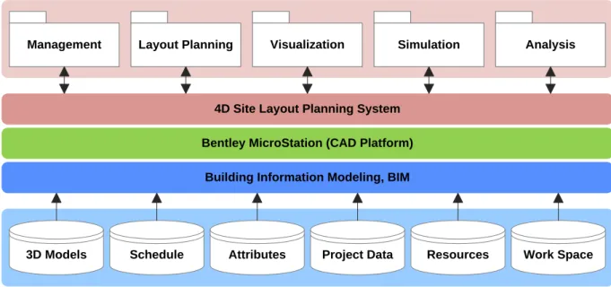
SYSTEM DESIGN AND IMPLEMENTATION
As shown in Fig.4, this research takes advantage of Building Information Modeling (BIM) technology to enable the 4D site layout planning system to gener-ate an efficient site layout plan. This system is divid-ed into three tiers: the first tier consists of the BIM models, which describe and store information about entire engineering projects and the results of site layout planning; the second tier is the Bentley MicroStation which provides functions for 2D/3D Data Acquisition, Storage, Editing, Processing, Anal-ysis, Display; the third tier is the 4D site layout plan-ning system developed in this research. The imple-mentation of this system was carried out in the MicroStation Visual Basic for Applications (MVBA) environment, and encapsulates the complicated planning and optimization functions into five easy-to-use modules. These five modules are:
Management: This module is responsible for
managing project information and system data, including project schedule and data, resource allocation, 3D models, and site layout planning results.
Layout Planning: This module provides
func-tions for users to create and define the size, lo-cation, purpose and exits of workspaces. The layout can be used to simulate and analyze usability and efficiency according to project schedules and resource allocation plans. Visualization: This system provides tools for
defining the relationships between the objects in the 3D model and time schedule. This ena-bles users to understand the processes of con-struction and resources transportation via 4D visualization. In addition, the system can pro-vide the relevant project information through 1D text, 2D graph and 3D models.
Simulation: In our system, users can observe
simulations of the entire construction process. For each simulation run, the total transportation time and distance of resources is recorded and evaluated.
Analysis: The constraint-based simulation is
run repeatedly, and then a Monte Carlo analy-sis is performed by the system in order to find an optimal site layout plan.
4D Site Layout Planning System Layout Planning
Management Visualization Simulation Analysis
3D Models Schedule Attributes Project Data Resources Work Space Bentley MicroStation (CAD Platform)
Building Information Modeling, BIM
Fig.4. System framework of the 4D site layout planning system
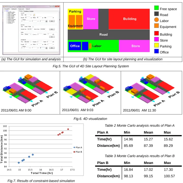
DEMONSTRATION
Example
A simple construction project was used as an exam-ple to verify and demonstrate the functionalities of the 4D site layout planning system. The construction project is a 2-floor precast engineering project; the area of the construction site is 80m*42m. In this system, the quantity of the available resources was specified and limited according to the site layout plan.
Table 1 summarizes the simulated variables and constraints in this research. For each resource con-figuration, a Monte Carlo analysis consisting of many simulation runs was performed, with each run result-ing in a different transportation path. From the results of the simulation, planners can select the best solu-tion according to their objectives and their particular needs.
Table 1 Simulated variables and constraints
Site Layout Plan Labor Excavator Truck Crane
Plan A 10 1 2 2
Functionalities
The functionalities of this system can be divided into four parts as explained in the following section. Fig. 5 illustrates the main graphical user
inter-face (GUI) of the 4D site layout planning sys-tem. Before starting the simulation, the user needs to define the resources available for the project. The user can easily manage the activi-ty tree and its resources by creating and ad-justing the relationships among the various ac-tivities and resources through the GUI, as shown in Fig. 5(a).
The planner can create various site layout plans in the 3D visual environment for simula-tion and analysis. The 3D objects in the site model are represented in different colors, de-pending on their purpose and type. Fig. 5(b) shows the color scheme implemented in this work.
The constraint-based simulation is then re-peatedly run in order to find an efficient site layout. The resultant detailed transportation process can be easily combined with the 3D model of the project to generate 4D visualiza-tion as shown in Fig. 6.
Fig. 7 shows the results of the Monte Carlo analysis conducted in this research. In this ex-ample, the shortest transportation time and dis-tance is given by Plan A, as shown in Table 2 and Table 3. The application of Monte Carlo analysis does not guarantee the finding of an optimum solution. However, this approach en-ables one to analyze and visualize the various candidates of site layout plan, and clearly iden-tify good solutions, albeit manually. Based on transportation times and distances for labor and equipment, one may say that Plan A is more efficient than Plan B.
Free space Road Labor Equipment Building Store Parking Office
(a) The GUI for simulation and analysis (b) The GUI for site layout planning and visualization Fig.5. The GUI of 4D Site Layout Planning System
2011/06/01 AM 9:00 2011/06/01 AM 9:03 2011/06/01 AM 11:30 Fig.6. 4D visualization 84 86 88 90 92 94 96 98 100 102 14.5 15 15.5 16 16.5 17 17.5 T o ta l D is ta n c e ( k m ) T o t a l T i m e ( h r ) Plan A Plan B
Fig.7. Results of constraint-based simulation
Table 2 Monte Carlo analysis results of Plan A
Plan A Min Mean Max
Time(hr) 14.96 15.27 15.62
Distance(km) 85.69 87.39 89.29
Table 3 Monte Carlo analysis results of Plan B
Plan B Min Mean Max
Time(hr) 16.84 17.02 17.30
CONCLUSIONS
Since space constraints affect the site layout of re-sources, and influence productivity on the construc-tion site, it is essential that possible site layouts are generated and analyzed in advance, so that the available space can be used more efficiently. Fur-thermore, efficient construction site planning involves the simultaneous assessment of schedule and site layout so that space can be used more efficiently and dynamically. In response to these needs, this research developed a 4D Site Layout Planning Sys-tem to assist planners in developing efficient site layouts, and to observe the results dynamically and visually.
ACKNOWLEDGMENTS
The authors would like to thank the R.O.C. National Science Council for their financial support under Grant No. NSC100-2221-E-151-055.
References
1. Kaming, P.F., Holt, G.D., Kometa, S.T. and Olomolaiye, P.O., “Severity diagnosis of productivity problems - a reliability analysis”, International
Jour-nal of Project Management, Vol. 16, No. 2, pp.
107-113, 1998.
2. Sanders, S.R., Thomas, H.R. and Smith, G.R., “An Analysis of Factors Affecting Labor Productivity in Masonry Construction”, Pennsylvania State
Univer-sity, University Park, PA, 1989.
3. Sanad, H.M., Ammar, M.A. and Ibrahim, M.E., “Op-timal Construction Site Layout Considering Safety and Environmental Aspects”, Journal of
Construc-tion Engineering and Management, Vol. 134, pp.
536-544, 2008.
4. Heeson, D. and Mahdjoubi, L., “Trends of 4D CAD applications for construction planning”, Construction
Management and Economics, Vol. 22, pp. 171-182,
2004.
5. Chau, K.W., Anson, M. and Zhang, J.P., “4D dy-namic construction management and visualization software: 1. Development”, Automation in
Construc-tion, Vol. 14, pp. 512-524, 2005.
6. Akinci, B., Fischer, M. and Kunz, J., “Automated Generation of Work Spaces Required by Construc-tion Activities”, Journal of ConstrucConstruc-tion Engineering
and Management, Vol. 128(4), pp. 306-315, 2002.
7. Mallasi, Z., “Identification, and Visualization of Con-struction Activities’ Workspace Conflicts Utilizing 4D CAD/VR Tools”, 1st ASCAAD International
Confer-ence, e-Design in Architecture, KFUPM, Dhahran,
Saudi Arabia, pp. 235-253, 2004.
8. Wu, I.C. and Chiu, Y.C., “4D Workspace Conflict Detection and Analysis System”, Proceedings of the
10th International Conference on Construction Ap-plications of Virtual Reality, November 4-5th, Sendai,
Japan, 2010.
9. Hegazy, T. and Elbeltagi, E., “EvoSite:Evolution-Based Model for Site Layout Planning”, Journal of
Computing in Civil Engineering, ASCE, Vol. 13, No.
3, pp. 198-206, 1999.
10. Mawdesley, M.J., Al-jiborui, S.H. and Yang, H., “Genetic algorithm for construction site layout in project planning”, Journal of Construction
Engineer-ing and Management, Vol. 128, No. 5, pp. 418-426,
2002.
11. Yeh, I.C., “Construction-Site Layout Using Annealed Neural Network”. Journal of Computing in Civil
En-gineering, Vol. 9, No. 3, pp. 201-208, 1995.
12. Badiru, AB. and Arif, A., “FLEXPERT: Facility Lay-out Expert System Using Fuzzy Linguistic Relation-ship Codes”, IIE Transaction, Vol. 28, pp. 295-308, 1996.
13. Meller, R.D. and Bozer, Y.A., “A new simulated annealing algorithm for the facility layout problem”,
International Journal of Production Research, Vol.
34, No. 6, pp. 1675-1692, 1996.
14. Baykasoglu, A. and Gindy, N.N.Z., “A simulated annealing algorithm for the dynamic layout problem”,
Computers & Operations Research, Vol. 28, No. 14,
pp. 1403-1426, 2001.
15. Montreuil, B., “A Modeling Framework for Integrat-ing Layout Design and Flow Network Design”,
Pro-ceedings of the Material Handling Research Collo-quium, Hebron, Kentucky, pp. 43-58, 1990.
16. Easa, S. M. and Hossain, K.M.A., “New Mathemati-cal Optimization Model for Construction Site Layout”,
Journal of Construction Engineering and Manage-ment, ASCE, Vol. 134, pp. 653-662, 2008.
17. El-Rayes, K. and Said, H., “Dynamic Site Layout Planning Using Approximate Dynamic Program-ming”, Journal of Computing in Civil Engineering, ASCE, Vol. 23, pp. 119-127, 2009.
18. Foulds, L.R. and Robinson, D.F., “Graph Theoretic Heuristics for the Plant Layout Problem”,
Interna-tional Journal of Production Research, Vol. 16, No.
1, pp. 27-37, 1978.
19.Montreuil, B., Ratliff, H.D. and Goetschalckx, M., “Matching Based Interactive Facility Layout”, IIE
Transactions, Vol. 19, pp. 271-279, 1987.
20.Tompkins, J.A. and Reed, R.J., “An applied model for the facilities design problem”, International
Jour-nal of Production Research, Vol. 14, pp. 583-595,
1976.
21.Kaku, B.K., Thompson, G.L. and Morton, T.E., “A hybrid heuristic for the facilities layout problem”,
Computers in Operations Research, Vol. 18, pp.
241-253, 1991.
22. Goetschalckx, M., “An interactive layout heuristic based on hexagonal adjacency graphs,” European
Journal of Operational Research, Vol. 63, No. 2, pp.
304-321, 1992.
23. Van Slyke, R.M., “Monte Carlo Method and The PERT Problem”, Operations Research, Vol. 11, No. 5, pp. 839-860, 1963.
24. Fan, L and Senthil Kumar, A, “Development of ro-bust fixture locating layout for machining workpieces”, Proceedings of the Institution of
Me-chanical Engineers, Part B: Journal of Engineering Manufacture, Vol. 224, No. 12, pp. 1792-1803, 2010.