行政院國家科學委員會專題研究計畫 成果報告
台灣西南部活動斷層活動性近斷層監測之研究 (II)
計畫類別: 整合型計畫 計畫編號: NSC93-2116-M-002-008- 執行期間: 93 年 08 月 01 日至 94 年 07 月 31 日 執行單位: 國立臺灣大學地質科學系暨研究所 計畫主持人: 胡植慶 共同主持人: 饒饒饒饒饒饒饒饒饒饒饒 報告類型: 精簡報告 報告附件: 出席國際會議研究心得報告及發表論文 處理方式: 本計畫可公開查詢中 華 民 國 94 年 12 月 6 日
行政院國家科學委員會專題研究計畫 成果報告
台灣西南部活動斷層活動性近斷層監測之研究 (II)
計畫類別: 整合型計畫 計畫編號: NSC 93-2116-M-002-008 執行期間: 93 年 08 月 01 日 至 94 年 07 月 31 日 執行單位: 國立臺灣大學地質科學系暨研究所 計畫主持人 :胡植慶 共同主持人 :饒瑞鈞,劉啟清,林嶺中 華 民 國 94 年 12 月 6 日
Land subsidence in a mountain front as revealed by GPS measurements
in the Pingtung area, southwestern Taiwan
Corresponding author: Jyr-Ching HU
Address: Department of Geosciences, National Taiwan University, No. 1,
Sec. 4, Roosevelt Road, Taipei 106, Taiwan
E-mail: [email protected]
Tel: +886-2-23634860
Fax: +886-2-23636095
Land subsidence in a mountain front as revealed by GPS measurements
in the Pingtung area, southwestern Taiwan
Jyr-Ching Hu1, Hao-Tsu Chu2, Chin-Shyong Hou1,2, Rou-Fei Chen3, Pei-Fen Nien1
1
Department of Geosciences, National Taiwan University, Taipei, Taiwan, ROC
2
Central Geological Survey, MOEA, P.O. Box 968, Taipei, Taiwan, ROC
3
Observatoire Océanologique de Villefranche-sur-Mer, Université P. & M. Curie, France
Abstract
GPS measurements with three campaigns in southwestern Taiwan have been carried out by the Central Geologic Survey since 1996 for four years. The Pingtung-Kaohsiung network, which consists of 48 stations, was established to investigate crustal deformation and land subsidence. These GPS surveys mapped the complete velocity field of the Pingtung area in southwestern Taiwan relative to the Paisha station (S01R) of the Penghu islands (located in the Taiwan Strait), a recognizably stable continent shelf. GPS displacement velocities display the trends of variation in the investigated area. The horizontal station velocities varied from 32 mm/yr to 54 mm/yr in azimuths ranging from 247.2o to 272.6o with respect to the permanent station S01R. The horizontal station velocities decrease westwards and increase somewhat southwards. In terms of horizontal velocity vector trends, there is a contrast in kinematics in the study area. In the central and western part of the study area, GPS stations move generally toward the west, whereas in the Kaohsiung-Pingtung coastal area, the displacement vectors demonstrate a clear counter-clockwise deviation toward SW. The southern part of coastal area its offshore area show remarkable extension rates of 0.6-2.0 µstrain/year in an azimuth 015°-020°. This significant southward increasing of extensional strain rates is attributed to the lateral extrusion of blocks bounded by major discontinuities in the study area. For the
vertical movement, the station velocities are from ~13 mm/yr to -25 mm/yr. There are 20 stations with measured velocities pointing to subsidence in the southern part of the Pingtung plain. The significant subsidence rates from ~ 11 mm/yr to 25 mm/yr have been observed. Our results clearly demonstrate the existence of transtensional deformation which increases southward in the along-strike direction. They are consistent with the Holocene subsidence rate pattern in this region. The long-term subsidence rate is about 4 mm/yr near the coast of the southeastern part of the Pingtung plain. These data are highly consistent with the depositional isopach of fine-grained sediments in the subsidence area. The comparison with Holocene subsidence and isopach of fine-grained sediments suggest that about 75% of the present-day subsidence may result from decreasing groundwater level induced by over-pumping, adding much to the natural risk resulting from tectonic subsidence. We attribute this regional subsidence to be caused by an appreciable drop in groundwater level as revealed by rapid subsidence in the coastal areaof the Pingtung plain, as well as the transtentional deformation associated with tectonic extrusion.
1. Introduction
Land subsidence resulting from groundwater withdrawal has been observed in the world (Hix, 1995; Sun et al., 1999). Over-pumping of groundwater is thus a major concern in some coastal regions of Taiwan (Hsu, 1998; Liu et al., 1999; Fan, 2001). Groundwater has been abundantly used as an alternative to surface water, especially in the southwestern coastal region where the efficiency of surface water resource is severe due to the aquaculture and industry utilization since the 1970’s in Taiwan (MOEA, 1997). Problems of land subsidence in some coastal areas, with induced frequent flooding and infrastructure failure, have since resulted in serious economic
loss. In Taiwan, the total area affected by subsidence because of groundwater overdraft has exceeded 1,890 km2. According to a study of land subsidence in the coastal areas of the Pingtung County (MOEA, 1987), using aerial photographs from 1959 to 1985, the total area affected is about 10,347 hectares.
Geodetic leveling is a common technique for monitoring land subsidence on a long-term basis. However, satellite geodesy, especially Global Positioning System (GPS), has become a powerful method for geodetic monitoring over large areas (Dodson, 1995), with significantly increasing accuracy. Using survey mode GPS, a network of stations take measurements periodically, typically once or twice a year, over long periods. This was done in Taiwan, where accurate relative positioning with GPS allowed for detection of crustal deformation. For instance, to quantify the horizontal present-day deformation across the complex convergent plate boundary zone of Taiwan, 141 stations of the "Taiwan GPS Network" have taken surveys 4-6 times from 1990 to 1995 with dual-frequency geodetic receivers (Yu et al., 1997). However, concerning the analysis of vertical motion in the Pingtung plain, the coverage from these GPS stations was too sparse to allow for good quantification of deformation at the 1-10 km scale. For this purpose, a dense network has been established since 1996 in the Kaohsiung and Pingtung areas, which allows determination of crustal deformation of tectonic origin mixed with local subsidence resulting from groundwater withdrawal. In this study, we aim to characterise the deformation patterns and the local subsidence in the Pingtung plain (Fig. 1), based on unpublished data from extensive GPS survey from 1996 to 1999.
2. Tectonic and geological backgrounds of the Pingtung area
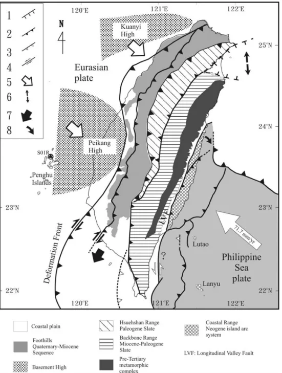
collision (Lallemand and Tsien, 1997). It is located in the transition zone between subduction to the south and collision to the north (Fig. 1). It corresponds to the southern part of the Plio-Pleistocene foreland basin in response to lithospheric flexure, which primarily results from the tectonic loading of the Central Range (Lin and Watts, 2002). The Pingtung plain covers an area of 1210 km2 and in map view exhibits a rectangular shape. In cross section, it shows the filling of unconsolidated sediments of the late Pleistocene and the Holocene. Most of these sediments consist of coastal to estuarine sand and mud, with abundant shallow marine to lagoonal shells and foraminifers (Shyu, 1999). The Pingtung plain is bounded by low hills of deformed Quaternary sediments to the north and the west. The metamorphosed Tertiary rocks of the lofty Central Mountain Range are bordered to the east. To the south, it opens to the Taiwan Strait. Wu (1993) suggested the Pingtung basin is a piggyback basin because the sediments are derived from the uplifted region of the Taiwan orogene and are confined by the Chaochou and Chishan Faults (Fig. 1). Chiang et al. (2004) suggested the Pingtung basin is located at the wedge-top depozone of the southern Taiwan foreland basin system.
The most significant geomorphologic feature of the Pingtung plain is the straight, N-S trending Chaochou Fault escarpment, which separates the alluvium plain and the high mountains. East of the Chaochou Fault, the mountains are mainly composed of Eocene-Miocene argillite, slate and meta-sandstone. Based on tectonic analysis of outcrop-scale faults, a predominant transtensional tectonic regime with NNE to NE extension and ESE to SE compression was reconstructed on the eastern side of the Chaochou Fault (Chan et al., 2000). The transition from transpression to recent transtension was also highlighted along the Chaochou Fault, and is probably related to the transition from collision to subduction, which highlights the active extrusion of the study area towards the southeast (Lacombe et al., 1999; 2001).
3. The Pingtung GPS Network
In order to analyse the present-day crustal deformation and land subsidence in the Pingtung area, the ‘Pingtung GPS Network’ covering the Pingtung-Kaohsiung area was established in 1995 by the Central Geological Survey, Ministry of Economic Affaires (Fig. 2). It is composed of 48 annually surveyed stations and one permanent, continuously monitoring station (S23R). During the period from August 1995 to August 1999, the mobile stations of the network were surveyed 3-4 times with dual frequency geodetic GPS receivers. The changes in baseline components derived from these repeated and continuous GPS measurements provided accurate estimates of the relative velocities of GPS stations in study area. In each survey, 4-8 stations were observed simultaneously with dual-frequency geodetic receivers (Trimble 4000 SSE Geodetic Surveyor). A station was usually active during more than two sessions, each session being composed of 6-14 hours of GPS data acquisition from all available satellites rising higher than a 15° elevation angle. The sampling interval was 15 seconds. Daily solutions were computed for continuous GPS data. The ionosphere-free linear combination of observations at the L1 and L2 frequencies are employed as the basis for estimating the station coordinates and baseline solutions.
We have processed the observed data with the official final precise ephemerides distributed by the IGS. All available temporary measurements and continuous recordings of GPS data were processed with the Bernese GPS software (v.4.2) developed at the Astronomical Institute of the University of Berne (Hugentobler et al., 2001). The observed data in each epoch survey were processed session by session to obtain the baseline solutions for all combinations of any two stations in the same session. The scatter of GPS measurement series taken over several years can be
employed as a relative indicator of precision. This long-term repeatability shows the effects of slowly varying systematic errors resulting from propagation delay, multipath, or fiducial network inconsistencies. To first approximation, assuming steady motion between stations during the four-year period, the scatter of data points was defined relative to a best-fit straight line on the plot of baseline components versus time (Dixon, 1991; Segall and Davis, 1997). The repeatability of baseline component (east, north, and vertical) or baseline length is obtained from the root-mean-square scatter about the linear trend. The baselines range from 3 to 21 km in length, most of them being shorter than 10 km. The average rates of length change of each baseline between nearby stations, which are usually observed in the same session, are determined from linear regression in time. For baseline lengths in the range of 3 to 21 km, the standard deviations were 3-6 mm for the north component, 3-6 mm for the east component and 10-15 mm for the vertical component.
4. Results and Discussions
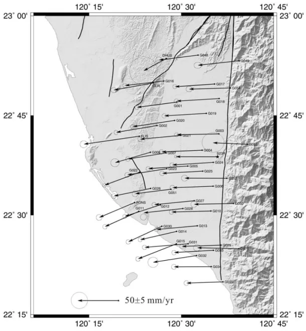
Our GPS surveys have provided a complete velocity field of SW Taiwan relative to the Paisha station of the Penghu archipelago, which belongs to the stable continental shelf. Horizontal GPS displacement velocities display the trends of variation in the investigated area. The station velocities range between 31 mm/yr and 56 mm/yr, with azimuths ranging between 245o and 273o with respect to the permanent station S01R. Both horizontal and vertical GPS displacement velocities display the trends of variation in the investigated area (Figs. 2 and 4). For the horizontal velocity field, the station velocities decrease westwards and gradually increase southwards. In terms of velocity vector trends, there is a contrast in kinematics in the study area. In the central and western part of the study area, the GPS
stations move mostly toward the west, whereas in the Kaohsiung and Pingtung coastal area the displacement vectors show a clear deviation toward the southwest (Fig. 2). As pointed out by Hu et al. (1997; 2001), this significant counter-clockwise rotation of displacement velocity vectors is related to transtensional deformation, and reflects the along-strike southward increase in extensional deformation in southwest Taiwan, in the transition zone from collision to subduction.
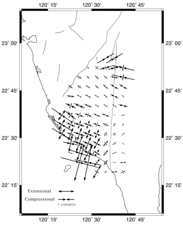
The changes in baseline lengths from the repeated GPS surveys in the Pingtung area are used to assess the spatial variation of the horizontal crustal strain over the region. It is assumed that, spatially, the crustal strain accumulates uniformly over each grids, and that the rate of strain accumulation is constant over the time period considered. The most prominent feature of the strain distribution patterns in the study area certainly corresponds to the significant extension in the coastal region of the Pingtung plain. The southern part of coastal area its offshore area show remarkable extension rates of 0.6-2.0 µstrain/year in an azimuth 015°-020°. By contrast, in the north and central part of the Pingtung plain, the small contractions mostly trends WNW-ESE directions. This significant southward increasing of extensional strain rates is attributed to the lateral extrusion of blocks bounded by major discontinuities in the study area (Fig. 1). These results are in general agreement with the previous models of lateral extrusion due to the low lateral confining conditions related to the Manila subduction zone as a free boundary or/and the presence of prominent Peikang High as a rigid indenter (Lu et Malavieille, 1994; Lu et al., 1998; Hu et al., 1997, 2001; Lacombe, 1999; 2001; Bos et al., 2002). Based on the rigid blocks models (Angelier et al., 1999; Lacombe et al., 2001), the escaping area comprises four rigid blocks moving toward the SW along major discontinuities with both the lateral and reverse shear. These discontinuities comprise the right-lateral reverse motion of the Deformation Front, right-lateral reverse motion of the Chishan fault, left-lateral
reverse motion of the Kaoping Fault and left-lateral reverse motion of the Chaochou Fault (Fig. 1). Based on the inversion of fault slip and continuous deformation deduced from GPS data in Taiwan (Yu et al., 1997), Bos et al. (2003) also presented a surface deformation model for southern Taiwan. This model exhibited a strain pattern with E-W contraction accompanied by a southward increase of predominantly N-S oriented extension.
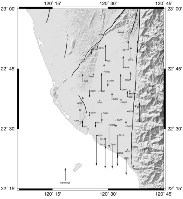
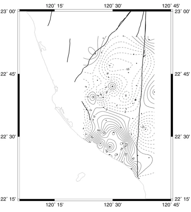
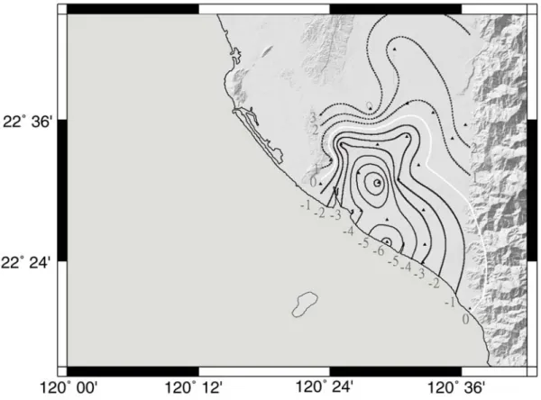
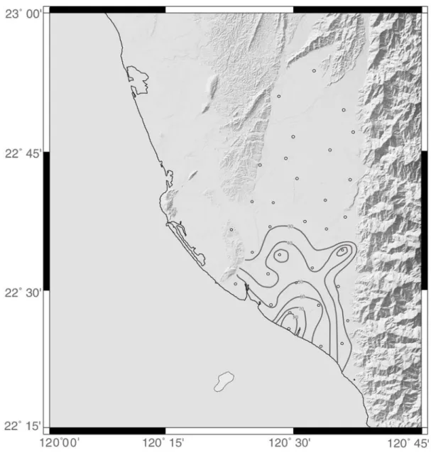
The vertical deformation revealed by our GPS measurements is distributed in two distinct regions, north and south, with dominant uplift and subsidence respectively (Figs 4 and 5). Chen (1984) pointed out that tectonically the area north of Pingtung area is characterized by uplift whereas the coastal area of Pingtung plain is dominated by subsidence. On the basis of GPS measurements, a significant subsidence rate from ~11 mm/yr to ~25 mm/yr is observed in the southern Pingtung plain. The maximum subsidence rate is compatible with the value of 25 mm/yr previously calculated based on conventional geodesy from 1914 to 1979 (Chen, 1984). This significant subsidence partly results from the large groundwater pumping for aquacultural purposes. Taking into account a recent study of groundwater table evolution (Kuo et al., 2001), the total subsidence of the southern Pingtung plain should be attributed to the mixed effects of regional tectonic tilting towards the southwest and local over-withdrawal of groundwater. On a longer time scale, Lai et al. (2002) quantified Holocene subsidence rates in the southern Pingtung plain, based on radiocarbon dating and using drilling cores (Fig. 6). Furthermore, the Holocene subsidence pattern is consistent with the isopach of fine-grained sediments in study area (Fig. 7). Based on their study, the average subsidence rate is about 4 mm/yr with a subsidence pattern similar to that of figure 5. This long-term average subsidence rate from Holocene in southern Pingtung rate is about 2 to 6 times smaller than the observation derived by GPS measurements from 1996 to 1999. We infer that this
regional subsidence is due to both the prominent groundwater level decrease which causes rapid subsidence in the coastal of the Pingtung plain, as well as the transtensional deformation associated with the tectonic extrusion.
5. Conclusion
Four years of GPS measurements with three campaigns have shown that subsidence in the Pingtung-Kaohsiung area is dominated by transtentional crustal deformation due to tectonic extrusion. The horizontal station velocities varied from 32 mm/yr to 54 mm/yr in azimuths ranging from 247o to 273o with respect to the permanent station (S01R) located in the stable continental shelf. The southern part of coastal area its offshore area show remarkable extension rates of 0.6-2.0 µstrain/year in an azimuth 015°-020°. This significant southward increasing of extensional strain rates is attributed to the lateral extrusion of blocks bounded by major discontinuities in the study area. For the vertical movement, the station velocities range from 13 mm/yr to -25 mm/yr. There are 20 stations with recorded velocities showing subsidence in the southern part of the Pingtung plain. Significant subsidence rates from ~11 mm/yr to ~25 mm/yr have been observed. These results clearly demonstrate the existence oftranstensional deformation and the southward increase of extensional deformation in the along-strike direction in the whole study area. The comparison with the pattern of Holocene subsidence rates (about -4 mm/yr in the same area) and isopach of fine-grained sediments suggests that about 75% of this subsidence may result from decreasing groundwater level induced by over-pumping. The human factor thus adds major local contribution to the natural risk that results from tectonic subsidence associated with tectonic extrusion and lateral extrusion at the southern tip of the Taiwan collision belt.
Acknowledgments
We benefited fruitful discussions and comments from Jacques Angelier, Chia-Yu Lu, Yu-Chang Chan, Meng-Long Hsieh, Shui-Bei Yu and Benoit Deffontaines. This research was supported by National Science Council of Taiwan grant (NSC 91-2119-M-002-020) and theCentral Geological Survey of the MOEA. Some figures were made using the GMT software written by Paul Wessel and Walter H. F. Smith.
References
Bos, A.G., Spakman, W., Nyst, M.C.J., 2003. Surface deformation and tectonic setting of Taiwan inferred from a GPS velocity field. J. Geophys. Res. 108(B10), 2458, doi:10.1029/2002JB002336.
Chen H.-F., 1984. Crustal uplift and subsidence in Taiwan: an account based upon retriangulation results. Spec. Publ. Central Geol. Surv., 3, 127-140.
Chan Y.-C., Lu C.-Y., Lee J.-C., 2000. Orogen-parallel shearing in on-going mountain building: a case study form the southeastern Central Range of Taiwan. Eos. Trans. AGU, Fall Meet. Suppl., Abstract, 81.
Chiang C.-S. Yu, H.-S., Chou Y.-W., 2004. Characteristics of the wedge-top depozone of the southern Taiwan foreland basin system. Basin Research 16, doi: 10.111/j.1365-2117.2003.00222.x, 65-78.
Dixon, T.H., 1991. An introduction to the Global Positioning System and some geological applications. Review of Geophysics 29, 249-276.
Dodson A.H., 1995. GPS for height determination, Survey Reviews, 33, 66-76.
Fan K.-L., 2001. Some coastal environmental problems in Taiwan, Acta Oceanographica Taiwanica, 39, 1-10.
Hix G.L., 1995. Land subsidence and ground water withdrawal, Water Well Journal, 49, 37-39.
Hsu S.-K., 1998. Plan for a groundwater monitoring network in Taiwan. Hydrogeological Journal, 6, 406-415.
Hu J.-C. Angelier J. Yu S.-B., 1997. An interpretation of the active deformation of southern Taiwan based on numerical simulation and GPS studies. Tectonophysics, 274, 145-169.
Hu J.-C. Yu S.-B. Angelier J. Chu H.-T, 2001. Active deformation of Taiwan from GPS measurements and numerical simulations. Journal of Geophysical Research 106, 2265-2280.
groundwater system model of Pingtung Plain, Proceedings of the Symposium on Groundwater and Hydrogeology of the Pingtung Plain, Taipei, 139-152. Hugentobler U., Schaer S., Fridez P., 2001. Bernese GPS software, Version 4.2,
Astronomical Institute, University of Berne, 515 pp.
Kuo C.-H., Chan Y.-C., Wang C.-H., 2001. Subsidence: over withdrawal groundwater, tectonic or both? Eos. Trans. AGU, Fall Meet. Suppl., Abstract, 82, F479. Lacombe O., Mouthereau, F., Deffontaines, B., Angelier, J., Chu, H.-T., Lee, C.-T.,
1999. Geometry and Quaternary kinematics of fold-and-thrust units of southwestern Taiwan. Tectonics, 18, 1198-1223.
Lacombe O., Mouthereau, F., 2001. Angelier J. Deffontaines B., Structural, geodetic and seismological evidence for tectonic escape in SW Taiwan. Tectonophysics, 333, 323-345.
Lai, T.-H., Hsieh, M.-L., Liew, P.-M., Chen, Y.-G., 2002. Holocene rock uplift and subsidence in the coastal area of Taiwan. Eos. Trans. AGU, Fall Meet. Suppl., Abstract, 83, F1280.
Lai Y.-H. and Hsieh, M.-L., 2003. Late-Quaternary Vertical Rock-movement Rates of the Coastal Plains of Taiwan, 2003 Annual Meeting Geological Society, Taipei, 119.
Lallemand, S.E., Tien, H.-H., 1997. An introduction to active collision in Taiwan. Tectonophysics 274, 1-4.
Lin A.T., Watts A.B., 2002. Origin of the west Taiwan basin by orogenic loading and flexure of a rifted continental margin. Jouranl of Geophysical Research 107 (B9), 2185-2203.
Liu C.-W. Lin W.-S. Shang C. Liu S.-H., 1999. The effect of clay dehydration on land subsidence in the Yun-Lin coastal area, Taiwan. Environmental Geology, 40, 290-296.
Lu, C.-Y., Malavieille, J., 1994. Oblique convergence, indentation and rotation tectonics in the Taiwan Mountain Belt: Insights from experimental modeling. Earth Planet. Sci. Lett. 121, 477-494.
Lu, C.-Y., Jeng, F.-S., Chang, K.-J., Jian, W.-T., 1998. Impact of basement high on the structure and kinematics of western Taiwan thrust wedge : insights from sandbox models. TAO 9(3), 533-550.
Malavieille, J., Lallemand, S.E., Dominquez, S., Deschamps, A., Lu, C.-Y., Liu, C.-S., Schnürle, P., 2002. Arc-continent collision in Taiwan: new marine observations and tectonic evolution., in Byrne, T.B., and Liu, C.-S., eds, Geology and Geophysics of an Arc-Continent Collision, Taiwan. Boulder, Colorado, Geol. Soc. Am. Special Paper 358, 187-211.
coastal areas in Pingtung county, 77 pp
MOEA (Ministry of Economic Affaires), 1997. The execution of land subsidence prevention and reclamation plan in 1997 (in Chinese), MOEA, Taipei, Taiwan. Segall, P. Davis, J.L., 1997. GPS applications for geodynamics and earthquake studies.
Annual Review of Earth Planetary Science 25, 301-336.
Shyu B.H., 1999. The sedimentary environment of southern Pingdong plain since the last glacial, Master Thesis, National Taiwan University, Taipei, pp 212.
Sun H., Grandstaff, D., Shagam R., 1999. Land subsidence due to groundwater withdrawal: potential damage of subsidence and sea level rise in southern New Jersey, USA. Environmental Geology, 34, 290-296.
Teng, L.S., 1990. Geotectonic evolution of late Cenozoic arc-continent collision in Taiwan. Tectonophysics 183, 57-76.
Wessel, P., Smith, W.H.F., 1998. New, improved version of the Generic Mapping Tools Released. EOS Trans. AGU 79, 579.
Wilson A.M., Gorelicks, S., 1996. The effects of pulsed pumping on land subsidence in the Santa Clara Valley, California. Journal of Hydrology 174, 375-396. Wu, L.-C., 1993. Sedimentary basin succession of the upper Neogene and Quaternary
Series in the Chishan area, southern Taiwan and its tectonic evolution. National Taiwan University PhD Thesis, 212pp.
Yu, S.-B., Chen H.-Y., Kuo L.-C., 1997. Velocity field of GPS Stations in the Taiwan area. Tectonophysics, 274, 41-59.
Yu, S.-B., Kuo, L.-C., Punongbayan, R.S., Ramos, E.G., 1999. GPS observation of crustal deformation in the Taiwan-Luzon region, Geophys. Res. Lett. 26, 923-926.
Fig. 1. Tectonic framework and main structural units in Taiwan (modified after Teng, 1990; Hu et., 2001; Lacombe et al., 2001; Malavieille et al., 2002). Large Open arrow shows the direction and velocity of plate convergence of Philippine Sea plate and Eurasian plate relative to the South China block (Yu et al., 1997; 1999). Major thrust faults with triangles are on the upthrust side. Numbers indicate 1, normal fault; 2, thrust fault (active); 3, thrust fault (inactive); 4, strike-slip fault; 5, indenter of rigid promontory at the front of the active belt; 6, back-arc opening; 7, tectonic escape; 8, migration of thethrust front.
Fig. 2. Horizontal velocity field of GPS stations in Pingtung plain relative to Paisha, Penghu (S01R) from 1996 to 1999. Locality of S01R, see Figure 1. The 95% confidence ellipse is shown at the tip of each velocity vector. Solid star indicates permanent GPS station. Solid circles are survey mode stations. Thick lines are active faults. Shaded topography is based on 40 m x 40 m DEM.
Fig. 3. Principal strain rates in the Pingtung area. Convergent arrows denote contraction, whereas divergent arrows represent extension. Thick grey lines indicate the fault traces based on data of MOEA (Lin et al., 2000).
Fig. 4. Vertical velocities of GPS stations in the Pingtung plain relative to Paisha, Penghu (S01R) from 1996 to 1999. Symbols are the same as Figure 2.
Fig. 5. Contours of vertical velocities of GPS stations in the Pingtung plain relative to Paisha, Penghu (S01R) from 1996 to 1999. Contour interval is 2 mm/yr. Dotted contours indicate uplift and solid contours are subsidence. Symbols are the same as Figure 2.
Fig. 6. Contours of vertical uplift and subsidence rates (mm/yr) of Holocene based on radiocarbon dating and drilling cores (Modified after Lai et al., 2002). White line denotes the boundary of uplift and subsidence region. Solid lines indicate subsidence whereas dotted lines represent uplift. Solid triangles indicate the localities of well sites.
Fig. 7. Contours of percentage for depositional isopach of fine-grained sediments in subsidence area (Modified after Huang et al., 1998). Open circles indicate the localities of well sites.