A study of slope monitoring and warning
system for Taipei Water Source Domain (A
Case Study of Highway 9 at Zhongzhi, Wulai,
New Taipei City).
Hung-Yi Su, Yi-Ming Huang, and Wen-Shang Chou, Hsiu-Feng Liu, Chun-Ho Chou,Jyh-Haur Lu,Shieh-Ho Lai
Abstract
Typhoon Soudelor in 2015 triggered landslides at Wulai area, around the 10.2 k on the Provincial Highway No. 9, damaging the traffic and causing casualties. Based on the available data, the study area was divided into three potential landslide areas: A, B, and C. Area A refers to the upper slopes of DF229, Area B was the location of Zongzhi tribe, and Area C was around the Zongzhi sport fields. The layout and the depths of boring holes were determined based on the collected information. The electrical resistivity survey, ultrasonic photography of bore holes, and -magnetic susceptibility measurement were conducted in the plan.
The slope safety monitoring was planned by installing monitoring instruments and sensors on the site. There were inclinometers (and observation walls), water pressure meters, rain gauges, and CCD camera were installed. In this project, the visibility of applying Low-Power Wide-Area Network (LPWAN) technique was evaluated by planning an Internet of Things (IoT) system of slope safety monitoring. The design of the IoT considered the power supply and communication availability. Solar panels were used for water pressure meters, and the batteries was used for LPWAN base station and CCD camera. The operation time of 72 hours was expected after the local power interruptions.
A slope safety monitoring system was established in association with the installement of monitoring sensors. The monitoring system and the corresponding mobile App collect the in-situ data from sensors and display the observations of rainfall, ground water table, water turbidity, inclinometer measurement, and CCD images. The warning status is represented as lights on the platform. When a warning threshold is reached, the notification will be sent to agencies, and messages push to the corresponding persons. The system also provides a map platform to show the visualized data and its trend. Keywords: potential landslide, LPWAN, IoT, landslide monitoring, warning model
1 Introduction
Typhoon Soudelor in 2015 had caused 6-hr accumulated rainfall of 442 mm, which was over the design of 200-yr return period, and triggered landslides at Wulai area, around the 10.2 k on the Provincial Highway No. 9, damaging the traffic and causing casualties. The landslide counter measurements and mitigation was carried out by the Taipei Branch, Soil and Water Conservation Bureau, commissioned by the Taipei Water Management Office, WRA.
2 Information collection and site investigation
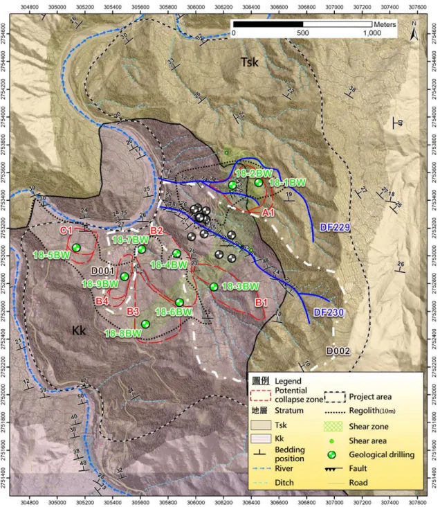
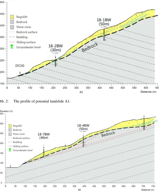
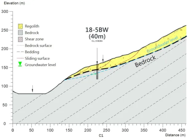
Information about landslides and site investigations, reports, and images had been collected for the project application. Based on the available data, the study area was divided into three potential landslide areas: A, B, and C. Area A refers to the upper slopes of DF229, Area B was the location of Zongzhi tribe, and Area C was around the Zongzhi sport fields. The layout and the depths of boring holes was determined based on the collected information. The electrical resistivity survey, ultrasonic photography of bore holes, and -magnetic susceptibility measurement were conducted in the plan. The thickness of piling up material varied over the study area, from 0.75 m to 39.6 m. According to the boring results, the thickest Regolith layer, 39.6 m, was at 18-6BW in area B. The actual thickness of regolith layer can be thicker in the slopes. The regolith material is usually loose and weak in engineering properties, and is potentially the failure material. The regolith layer covered at oblique slopes in area A, and at dip slopes in areas B and C. Because of the interface between the rock bed and soil layers, the failure mechanism was different at locations in the study area. There was potential of shallow landslides, deep-seated landslides or slides along soil-rock interfaces in this area.
From the available document and field geology survey, there geologic structures of Feitzuiku Anticline, Huoshaochang Syncline, Chatienshan Anticline, and Chungchih Fault in the study area. Affected by the regional geologic structures, the rock mass was fractured and disturbed, as found in bore holes of 18-1BW, 18-6BW, and 18-8BW, implying the disturbance of outcrops and existence of shearing bands (found in drilling cores). Some rack mass was fractured or fractured with fillers, or formed fault gouge or fault breccia. Because of the existence of fractured material, there was potential of rock slides in the study area.
The UAS was used to capture the locations of gullies and slopes of the study area. The orthophotos and digital elevation model was also constructed for reference. There were two barren lands was identified: one is the landslide at upper stream of DF230, which was mitigated with engineering measurements, and the other one was located at the north of the study area, where there was no structures or protected objects. There is no
obvious change of the area of the north-side barren land, according to the aerial photos in recent years.
Abb. 2: The profile of potential landslide A1.
Abb. 4: The profile of potential landslide C1.
3 Slope monitoring design and pilot test of IoT
The slope safety monitoring was planned by installing monitoring instruments and sensors on the site. There were inclinometers (and observation walls), water pressure meters, rain gauge, and CCD camera were installed.
In this project, the visibility of applying Low-Power Wide-Area Network (LPWAN) technique was evaluated by planning an Internet of Things (IoT) system of slope safety monitoring. The design of the IoT considered the power supply and communication availability. Solar panels were used for water pressure meters, and the batteries was used for LPWAN base station and CCD camera. The operation hour of 72 hours was expected after the local power interruptions.
The LPWAN technique of LoRa, Sigfox, and NB-IoT was evaluated in this project. Considering the transmission frequency and bandwidth, availability of 4G signals, and investment and maintenance costs, the solution of LoRa was adopted in this project to develop a pilot monitoring system for slope safety. During the project period, data loss was observed several times. The antenna of base station was upgraded to higher dbi and resolved the data loss problem.
Abb. 5: Communication layout of IoT for slope safety monitoring.
4 Landslide warning model
Based on the study of this project and the available monitoring data within or near the study area from other agencies, the warning and action thresholds about the monitoring system were suggested as shown in Table 1.
Tab. 1: Warning and action thresholds and recommended response Thresholds
Sensors Alert (blue) Waring (yellow) Action (red)
Monitoring System
Rainfall - ETR2 or QPF predicted rainfall ≧350*70% mm ETR2 or QPF predicted rainfall >350 mm
Inclinometer 2 mm/mo. Certain displacements or 5 mm/mo.
Certain displacements or 10 mm/mo.
Groundwater table
Rising 5 m than normal elev. or rising 5 m per 5 hr
Rising 10 m than normal elev. or rising 5 m per 2 hr
-
Recommended Response
Continue observation and watch the trend.
Notify relative units and take necessary actions.
Local government should advise or force evacuation of residents in the dangerous areas to the shelters. Internet Signal LPWAN(LoRa) 4G LTE Server rain gauge CCD 4G LTE Router water pressure meters data recorder PoE Injector 4G LTE Router LoRa
5 Slope safety monitoring system
A slope safety monitoring system was established in association with the installement of monitoring sensors. The monitoring system and the corresponding mobile App collect the in-situ data from sensors and display the observations of rainfall, ground water table, water turbidity, inclinometer measurement, and CCD images. The warning status is represented as lights on the platform. When a warning threshold is reached, the notification will be sent to agencies, and messages push to the corresponding persons. The system also provides a map platform to show the visualized data and its trend. In response to any warnings, the mobile App provides sharing functions to send necessary information from the monitoring system to certain people or groups, via Line App or emails.
Abb. 6: Monitoring system and mobile App for 10.2 k Highway No. 9.
6 Conclusions
In addition to the engineering mitigations, the landslide monitoring and its warning model was established in this project, in association with the investigation of debris flows DF229 and DF230, potential large-scale landslide areas D001 and D002, and potential erosion zones.
Acknowledgement
The present study was supported by the project “Program of Slope Monitoring and Warning System of Highway 9 at Zhongzhi, Wulai, New Taipei.” financed by Taipei Water Management Office, WRA.
References
Liao, R.T., Chen, C.W., Chi, C.C., Lin, H.H. (2013). Study of slope displacement for management from landslide monitoring cases in Taiwan. Sino-Geotechnics No.136.
Japan Association for Slope Disaster Management (1978), 地すべり対策技術設計実施要領, Vol.2.
USBR (1987). Embankment Dam Instrumentation Mnaual. TGS-SLOPEM106 (2017). Chinese Taipei Geotechnical Society.
Authors
Hung-Yi Su (corresponding Author) Yi-Min Huang
Feng Chia University Email: [email protected] Wen-Shang Chou Hsiu-Feng Liu Chun-Ho Chou Jyh-Haur Lu Shieh-Ho Lai