OBLIQUE CONVERGENCE BETWEEN TRENCH-ARC SYSTEM
AND CONTINENT-IMPLICATIONS FOR THE FORMAT1ON
OF THE SUBMARINE PHYSIOGRAPHY OFF
SOUTHERN TAIWAN
Ho-Shung Yu and Gwo-Shyh Song
ABSTRACT
The northern Manila Trench-Luzon Arc system and the juxtaposed Asian continental margin were successively deformed by collision which began at about 5 Ma ago and has been propagating southward at a rate of about 9cm/year. As a consequence, folding, thrusting and orogenic sedimentation related to the east-west compressive stress have deformed the Asian continental margin and the trench-arc system into the mountain range (Taiwan) which plunges southward into the sea. Off southern Taiwan the sea floor features several prominent alternating N-S trending linear ridges and troughs.
Beginning about 5 Ma, the northern tip of the Manila Trench has been progressively filled, closed and uplifted from north to south and compressed into the deformation front buried west of Taiwan. The northern portion of the Manila accretionary prism together with the Asian continental margin were deformed into the Central Range and its southern extension of the submarine Hengchun Ridge which ends at about 21°N. The northern segment of the forearc basin of the North Luzon Trough was deformed into the Longitudinal Valley, serving as the boundary between the Eurasian and Philippine Sea plates. The southern extension of the Longitudinal valley is represented by the Southern Longitudinal Trough, Huatung Ridge and Taitung Trough which merge together as the North Luzon Trough south of 21°N. During the last 3 Ma, the volcanic islands north of Lutao-Lanbsu Ridge then collided with the accreted Asian continental margin, resulting in the formation of the Coastal Range, and the Lichi melange accreted into eastern Taiwan.
INTRODUCTION
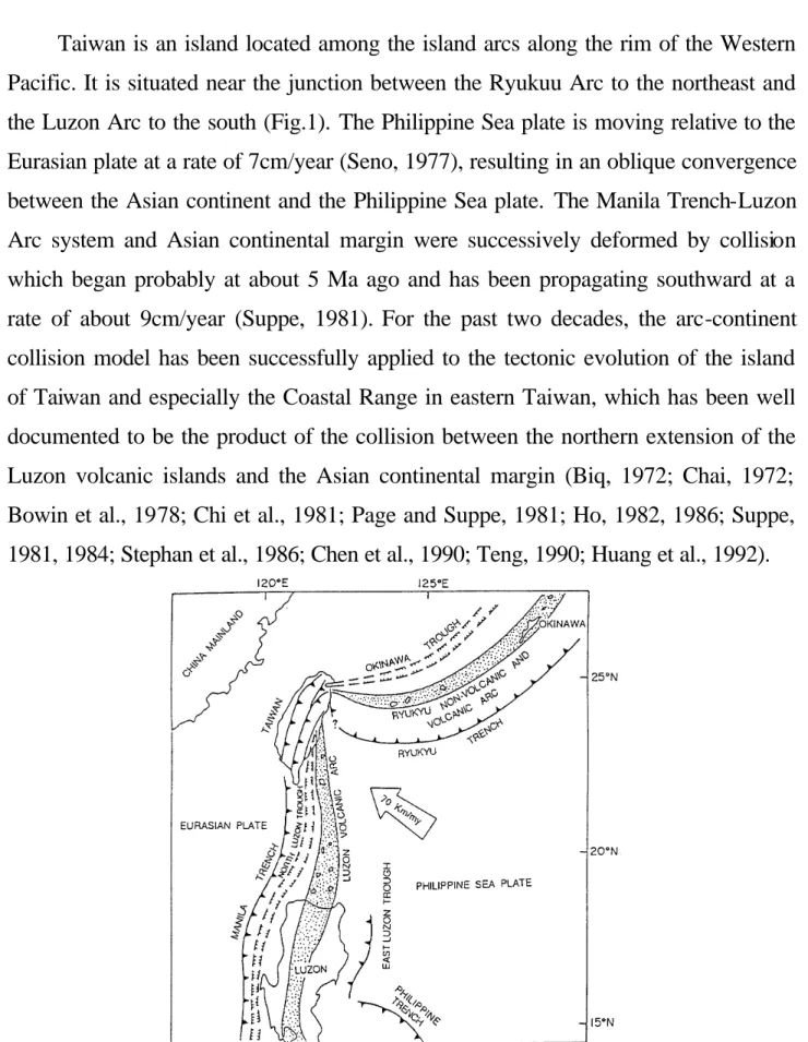
Taiwan is an island located among the island arcs along the rim of the Western Pacific. It is situated near the junction between the Ryukuu Arc to the northeast and the Luzon Arc to the south (Fig.1). The Philippine Sea plate is moving relative to the Eurasian plate at a rate of 7cm/year (Seno, 1977), resulting in an oblique convergence between the Asian continent and the Philippine Sea plate. The Manila Trench-Luzon Arc system and Asian continental margin were successively deformed by collision which began probably at about 5 Ma ago and has been propagating southward at a rate of about 9cm/year (Suppe, 1981). For the past two decades, the arc-continent collision model has been successfully applied to the tectonic evolution of the island of Taiwan and especially the Coastal Range in eastern Taiwan, which has been well documented to be the product of the collision between the northern extension of the Luzon volcanic islands and the Asian continental margin (Biq, 1972; Chai, 1972; Bowin et al., 1978; Chi et al., 1981; Page and Suppe, 1981; Ho, 1982, 1986; Suppe, 1981, 1984; Stephan et al., 1986; Chen et al., 1990; Teng, 1990; Huang et al., 1992).
Fig. 1. Cenozoic plate settings of the Asian continental margin near Taiwan (After Shyu and Chen, 1991)
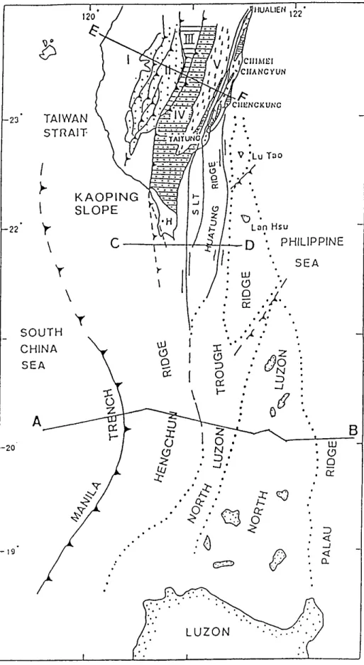
Fig. 2. Major morphotectonic features in the waterway between Taiwan and Luzon. SLT: Southern Longitudinal Trough (After Shyu and Chen, 1991).
Although the arc-continent collision model adequately accounts for the development of the tectonic features in Taiwan, it has not explained the nature and development of the submarine morphotectonic features between southern Taiwan and northern Luzon. For instance, where is the end of the northern extension of the Manila Trench towards Taiwan? How does the North Luzon Trough extend into the Longitudinal Valley onland Taiwan? Is it appropriate to call collectively the ridges and troughs off southern Taiwan an accretionary prism?
Indeed, the region between southern Taiwan and northern Luzon is a complex convergent zone and led Ho (1982, p.67) to state that "A conclusive solution to this problem may have to await more submarine information derived from marine geology, geophysics, and bathymetry in the waterway between Luzon and Taiwan". Recently the submarine morphotectonic features off southern Taiwan have been mapped (Fig.2) and discussed (Chen and juang, 1986; Chen et al., 1988; Lundberg, 1988; Huang and Yin, 1990; Chen et al., 1990; Liu et al., 1991; Shyu and Chen, 1991; Chen et al., 1992; Huang et al., 1992; Yu and Wen, 1992). These studies did not reach a concensus about correlating offshore units and geological elements onland Taiwan. However, these additional marine data combined with onland geology of Taiwan can provide critical information on the better understanding of the complex tectonics in Taiwan and its southern submarine region.
We emphasize the contraction rather than collision between trench-arc system and continent to account for the formation of the southern submarine morphotectonic features of Taiwan. This paper addresses the equally important role played by the trench, accretionary prism and forearc basin in addition to the volcanic islands of the arc during the process of convergence between the trencharc system and the continent. The Manila Trench rather than the volcanic islands of the Luzon Arc was first compressed obliquely with the Asian continent beginning about 5 Ma ago. The significance of the contraction between the Manila Trench and associated accretionary prism and the Asian continent has been noticed but not fully applied to the formation of the morphotectonic features off southern Taiwan (Suppe, 1981, 1984; Barrier and Angelier, 1986 and Pelletier and Stephan, 1986). The purpose of this paper is to call attentio n to the trench-arc system as a whole being compressed against the Asian continent in the evolution of southern Taiwan submarine region.
This paper presents three schematic E-W trending transacts from south to north across the Manila Trench-Luzon Arc system, offshore southern Taiwan and the island of Taiwan to illustrate tectonic processes varying from active subduction in the Manila Trench to active collision along the Coastal Range in eastern Taiwan.
MANILA TRENCH-LUZON ARC SYSTEM
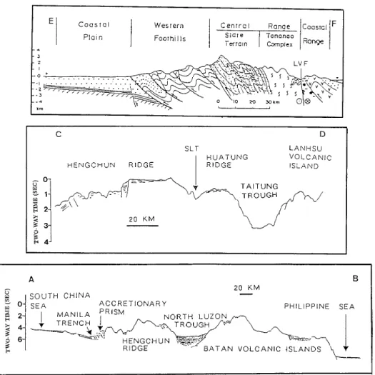
As shown in the transect A-B (Fig.3), the Manila Trench, Manila accretionary prism, North Luzon Trough and the Luzon Volcanic Arc progressing eastward comprise a typical trench-arc system (Karig and Scharman, 1975; Schweller, 1987). The Manila Trench, about 3 to 4km deep in front of the Manila accretionary prism, is partially filled by turbidities derived from the Chinese margin (Hayes and Lewis, 1984). Subduction of the South China Sea oceanic plate underneath the Philippine Sea plate takes place along the Manila Trench. The Manila accretionary prism has been formed at the lower trench slope by the accretion of scraped trench turbidities since late Miocene time (Hayes and Lewis, 1984). The North Luzon Trough represents the forearc basin receiving several kilometers of turbidities derived from the Luzon Arc (Hayes and Lewis, 1984). The North Luzon Trough is also characterized by a negative free-air anomaly (Watts et al., 1978). The Luzon volcanic islands extend northwards into the Lutao-Lanhsu volcanic islands off southeastern Taiwan. Clearly, the deep marine region between 21°N and north of Luzon is represented by an active subduction zone.
RIDGES AND TROUGHS OFF SOUTHERN TAIWAN
This transect C-D shows five morphotectonic units off southern Taiwan which are the Hengchun Ridge (HR), Southern Longitudinal Trough (SLT), Huatung Ridge (HTR), Taitung Trough (TT) and the Lutao-Lanhsu Ridge (LLR) from west to east (Fig.3). Apparently, the Manila Trench loses its identity as a linear deep ocean depression near Taiwan resulting from the compression against the Asian continent. The Kaoping Slope and the Hengchun Ridge can be regarded as deformed accretionary prism of the former Manila accretionary prism. The Southern Longitudinal Trough, Huatung Ridge and Taitung Trough all together can be regarded as parts of the deformed North Luzon Trough, evidenced by both the similar negative free-air anomaly and bathymetric low (Chen et al., 1992).
Fig. 3. Geological cross sections through the island of Taiwan and its southern offshore areas. Locations are shown in Fig.2. After Huang et al. (1992) (A-B, C-D) and Teng (1990) (E-F).
The Lutao-Lanhsu Ridge maintains as the undeformed northern extension of the Luzon Arc. The presence of ridges and troughs suggests that the region between southern Taiwan and north of 21°N has been undergone convergence by the process of collision rather than subduction between the Philippine Sea plate and the Eurasian plate. It should be noted that the subduction stopped along this deformed segment of the Manila Trench where it extends northward into Taiwan.
Thus, in the offshore region north of the Manila Trench-Luzon Arc convergent zone it appears that the trench, accretionary prism and the forearc basin were already deformed whereas the volcanic islands of Lutao and Lanhsu have not yet collided with the Asian continent.
THE ISLAND OF TAIWAN
The transect E-F shows five major tectonic units across the island of Taiwan which are the Coastal Plain, Western Foothill, Central Range, the Longitudinal Valley and the Coastal Range from the west to east (Fig.3). Previous studies (Suppe, 1981,1984; Barrier and Angelier, 1986; Pelletier and Stephan, 1986 and Teng, 1990) clearly pointed out that the Coastal Range is the product of the northern extension of the Luzon Arc collided with the Asian continent. The Coastal Range consists mainly of volcanic series of andesites and andesitic breccias and intercalated Lichi melange.
The Longitudinal Valley can be regarded as a sutuae zone at the expense of the close of the northern extension of the North Luzon Trough due to the collision process. The Central Range is the mountain range of almost 4,000m altitude west of the Longitudinal Valley. It can be considered an intensively deformed Manila accretionary prism plus the imbricated and overthrusted Eocene-Oligocene sequence of the Asian continental margin. The Western Foothill represents the imbricated Upper Oligocene to Lower Pleistocene sequences of the Asian continental margin and parts of the deformed Manila accretionary prism. The Coastal Plain is the lowland covered by Quaternary clastics west of the Western Foothill. Bowin et al. (1978) suggested that the surface trace of the completely deformed Manila Trench buried underneath (deformation front) extends along the boundary between the Western Foothill and the Coastal Plain.
TECTONIC EVOLUTION
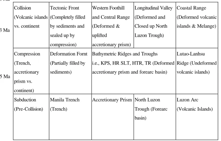
The tectonic evolution of the island of Taiwan and its southern offshore morphotectonic features can be divided into three stages: (1) Subduction, (2) Trench-continent convergence and (3) Arc-continent collision. The transformation of the northern part of the former Manila Trench-Luzon Arc system into the island of Taiwan including its southern submarine region is summarized in Table 1.
Table 1. Sequential events of oblique convergence between Manila Trench-Luzon Arc System and the Asian continent.
Collision (Volcanic islands vs. continent Tectonic Front (Completely filled by sediments and sealed up by compression) Western Foothill and Central Range (Deformed & uplifted accretionary prism) Longitudinal Valley (Deformed and Closed up North Luzon Trough) Coastal Range (Deformed volcanic islands & Melange)
Compression (Trench, accretionary prism vs. continent) Deformation Fornt (Partially filled by sediments)
Bathymetric Ridges and Troughs
i.e., KPS, HR SLT, HTR, TR (Deformed accretionary prism and forearc basin)
Lutao-Lanhsu Ridge (Undeformed volcanic islands) Subduction (Pre-Collision) Manila Trench (Trench)
Accretionary Prism North Luzon Trough (Forearc basin)
Luzon Arc (Volcanic Islands)
Before being compressed against the Asian continental margin, the Manila Trench in the vicinity of today's Taiwan maintained as a deep depression associated with strong seismicity. Beginning in the Late Miocene-Early Pliocene about 5 Ma ago, the Manila Trench-Luzon arc system was compressed against the Asian continent due to the northwestward movement of the Philippine Sea plate relative to the Eurasian plate. Following the convergence, the Manila Trench was changed into the tectonic front (Bowin et al., 1978; Stephan et al., 1986) where the trench was partly filled by sedimets and deformed. The subduction along the trench was replaced by compression.
0 Ma
3 Ma
The associated Manila accretionary prism and North Luzon Trough were deformed into N-S trending ridges and troughs. However, the volcanic islands of Lutao and Lanhsu underwent little deformation. During the last 3 Ma, the volcanic islands north of the Lutao and Lanhsu have collided with the accreted Asian continental margin to form the Coastal Range and Lichi Melange in eastern Taiwan (Page and Suppe, 1981; Chi et al., 1981). The linear Longitudinal Valley west of the Coastal Range became the convergent suture zone, serving as the plate boundary between the Eurasian and the Philippine Sea plates at the expense of the close of the northern extension of the North Luzon Trough.
The deformed accretionary prism and modified Asian margin sediments were converted into the Western Foothill and Central Range with numerous thrusts toward the west. The Central Range has been pushed onto the Eurasian plate and elevated to a maximal height of almost 4,000m resulting from the accreted continental margin-arc collision. The western limit of the Western Foothill characterized by westward imbricate thrusts is the surface expression of the deformation front of the former Manila Trench which was completely filled by sediments and sealed up.
CONCLUSIONS
The developments of tectonic features onland Taiwan and the submarine bathymetric features between Taiwan and Luzon can be interpreted in terms of convergence between the Manila Trench-Luzon Arc system and Asian continental margin. The convergence began probably in Miocene-Pliocene time (about 5 Ma), when the Manila Trench was partially filled by continent-derived sediments and partially sealed up, and continued compression changed the Manila accretionary prism and the North Luzon Trough into ridges and troughs. Intense collision probably has taken place from early Late Pliocene to the present (about 3 Ma to 0 Ma), when the volcanic islands of the Luzon Arc collided against the deformed accretionary prism accreted to the Asian continent and caused rapid uplift of the Central Range
accompanied by the formation of the Coastal Range in eastern Taiwan. The Manila Trench west of Taiwan orogen was totally sealed up and no longer can be considered to be a trench. The northern extension of the North Luzon Trough was sandwiched between Central Range and the Coastal Range and was deformed into the Longitudinal Valley, serving as the boundary between the Eurasian and Philippine Sea plates.
ACKNOWLEDGEMENTS
The development of this paper has benefited from discussions with a number of colleagues, especially L. Y. Chiao from Institute of Oceanography, National Taiwan University. We also thank C. Y. Lu, Department of Geology, National Taiwan University and F. W. Huang, Exploration Research and Development Institute, Chinese Petroleum Company for their constructive comments on the manuscript.
REFERENCES CITED
Barrier, E. and L. Angelier (1986) Active collision in eastern Taiwan: the coastal range. Tectonophysics 125: 39-72.
Biq, C. (1972) Dual-trench structure in the Taiwan-Luzon region. Proc. Geol. Soc. China 15: 65-75.
Bowin, C., R.S. Lu, C.S. Lee and H. Schouten (1978) Plate convergence and accretion in Taiwan-Luzon region. Am. Assoc. Pet. Geol. Bull 62: 1645-1672. Chai, B.H.T. (1972) Structure and tectonic evolution of Taiwan. Am. J. Sci
272: 389-442.
Chen, M.P. and W.S. Juang (1986) Seafloor physiography off southeastern Taiwan. Acta Oceanogr. Taiwanica 16: 1-7.
Chen, M.P., Y.T. Shieh and C.S. Shyr (1988) Seafloor physiography and surface sediments off southeastern Taiwan. Acta Geol. Taiwanica 26: 333-353.
Chen, H.W., Y.H. Yeh and C.H. Chen (1990) Tectonic model of southeastern Taiwan offshore and its implication of the evolution of the Coastal Range. Spec. Publ. Central Geol. Survey, ROC, no. 4, pp. 295-305 (in Chinese).
Chen, H. W., Y. H. Yeh and C. H. Chen (1992) Bathymetric ridges and troughs in the active arc-continent collision region off southeastern Taiwan: Discussion. Jour. Geol. Soc. China 35: 421427.
Chi, W. R., J. Namson and J. Suppe (1981) Stratigraphic record of plate interactions in the Coastal Range of eastern Taiwan. Mem. Geol. Soc. China 4: 155-194. HAYES, D.E. and S.D. LEwis (1984) A geophysical study of the Manila trench,
Luzon, Philippines. 1. Crustal structure, gravity and regional tectonic evolution. J. Geophys. Res. 89(B11): 9171-9195.
Ho, C. S. (1982) Tectonic evolution of Taiwan: Explanatory text of the geologic map of Taiwan.Ministry of Economic Affairs, Taipei, 126pp.
Ho, C. S. (1986) A synthesis of the geologic evolution of Taiwan. Tectonophysics 125: 1-16.
Huang, C. Y., C. T. Shyu, S. B. Lin, T. Q. Lee and D. D. Sheu (1992) Marine geology in the arc-continent collision zone off southeastern Taiwan: Implications for Late Neogene evolution of the Coastal Range. Mar. Geol. 107: 183-212.
Huang, C. Y. and Y. C. Yin (1990) Bathymetric ridges and troughs in active arc-continent collision off southeastern Taiwan. Proc. Geol. Soc. China 32: 351-371.
Karig, D. E. and G. F. Sharman (1975) Subduction and accretion in trenches. Geol. Soc. Am. Bull. 86: 377-389.
Liu, C. S., J. C. Su and C. T. Shyu (1991) Sedimentary structures of the arc-continent collision zone. Proc. 3rd Taiwan Symp. on Geophysics, Taipei, Taiwan, pp. 458. Lundberg, N. (1988) Present-day sediment transport paths south of the Longitndinal
Valley, southeastern Taiwan. Acta Geol. Taiwanica 26: 317-331.
PAGE, B. M. and J. SUPPE (1981) The Pliocene Lichi melange of Taiwan: its plate tectonic and olistostromal origin. Am. J. Sci. 281: 193-227.
PELLETIER, B. and J. F. STEPHAN (1986) Middle Miocene abduction and late Miocene beginning of collision registered in the Ilengchun Peninsula. Tectonophysics 125: 133-160.
Schwfller, W. J. (1987) Island arcs. In The Encyclopedia of Structural Geology and Plate Tectonics (Edited by C. K. Seyf ert), pp. 346-353. Van Nostrand Reinhold Co., New York.
Seno, T. (1977) The instantaneous rotation vector of the Philippine Sea plate relative to the Eurasian plate. Tectonophysics 42: 209-226.
Shyu, C. T. and S.C. Chen (1991) A topographic and magnetic analysis off southeastern Taiwan. Acta Oceanogr. Taiwanica 27: 1-20.
Stephan, J.F., R. Blancket, C. Rangin, B. Pelletier, J. Letouzfy and C. Muller (1986) Geodynamic evidence of the Taiwan-Luzon-Mindoro belt since the late Eocene. Tectonophysics 125: 245-268,
Suppe, J. (1981) Mechanics of mountain-buiding and metamorphism in Taiwan. Mem. Geol. Soc. China 4: 67-90.
Suppe, J. (1984) Kinematics of arc-continent collision, flipping of subduction, and backarc spreading near Taiwan. Mem. Geol. Soc. China 6: 21-34.
Teng, L. S. (1990) Geotectonic evolution of late Cenozoic arc-continent collision in Taiwan. Tectoriopbysics 183: 57-76.
Watt, A. B., J. H. Bodine and C. O. Bowin (1978) Free air gravity field. In A Geophysical Atlas of East and Southeast Asian Seas, Map Chart Set. MC-25 (Edited by Geol. Soc. Am.) Boulder, Colo., USA.
Yu, H. S. and Y. H. Wen (1992) Physiographic characteristics of the continental margin off southwestern Taiwan. Jour. Geol. Soc. China 35: 337-351.