科技部補助專題研究計畫成果報告
期末報告
台灣直轄市、縣(市)區域計畫的功能與挑戰
計 畫 類 別 : 個別型計畫 計 畫 編 號 : MOST 102-2410-H-004-199-執 行 期 間 : 102年08月01日至104年07月31日 執 行 單 位 : 國立政治大學地政學系 計 畫 主 持 人 : 蔡育新 計畫參與人員: 碩士班研究生-兼任助理人員:張懿萱 碩士班研究生-兼任助理人員:鍾佾芯 報 告 附 件 : 出席國際會議研究心得報告及發表論文 處 理 方 式 : 1.公開資訊:本計畫涉及專利或其他智慧財產權,2年後可公開查詢 2.「本研究」是否已有嚴重損及公共利益之發現:否 3.「本報告」是否建議提供政府單位施政參考:否中 華 民 國 104 年 10 月 26 日
中 文 摘 要 : 因國土計畫法經立法院通過的時程難以預估,為因應國土計畫實質 功能實施的迫切性,內政部自2010年起推動嶄新的法定直轄市、縣 (市)區域計畫之規劃,以提早落實以國土計畫因應全球氣候變遷 、優良農地保護等急迫性議題。然而,此計畫於台灣尚屬首次擬定 ,因此,其於規劃體系中的角色、功能、與內容,尚於摸索階段 ,相對於其上、下位計畫與縣市綜合計畫的差別,亦尚未釐清。就 理論面向,可納入此層級空間規劃的發展目標與議題、與其可運用 的政策工具、及應納入的相關部門等,似乎尚無完整的分析;尤其 為促進永續發展所採用的智慧成長或成長管理。就實務面向,熟悉 此新計畫的規劃內容相關人員亦少;如就智慧成長於此空間層級計 畫所可應用的工具,似尚為片段式的非系統式的採用。因此,本研 究的研究目的有四:(1)探討縣(市)區域計畫的功能與內容 ,(2)評估規劃中的縣(市)區域計畫的品質,(3)探討規劃成 功的因子與議題,(4)分析智慧成長於此計畫中的實施程度。研究 分析方法包或文獻回顧、「計畫品質評估」、與訪談;資料來源含 規劃技術報告、計劃書等。本研究成果預期可提供此空間層級規劃 之功能、內容的理論分析基礎,並為縣(市)區域計畫規劃手冊內 容修訂之參考。 主要的研究結果顯示:首先成長管理的相關政策普遍實施於包含都 市計畫與郊區(Rural area,非都市計畫區)的縣市區域計畫中,包 含承載上限、都市成長邊界線(Urban growth boundary)、「填補 式發展(Infill development)」與已發展區的農業區優先發展。 其次,都市計畫區中實施「計畫導向型發展」,郊區所在的非都市 計畫區則實施「開發許可制」。再其次,由於民眾對政府施政普遍 的信任不足與網路社交媒體的快速發展,於規劃過程自發性的民眾 參與較以往明顯提昇。除此,基於國安考量下的糧食自足率目標 ,優良農田的明訂劃設是此次縣市區域計畫的重要內容。有關目前 全球環境規劃中最迫切的全球氣候變遷議題,目前規劃以「調適策 略」重於「減緩」。最後,土地使用與交通兩部門間的統合規劃 ,於此區域計畫中較以往有更明顯的結合。 中 文 關 鍵 詞 : 縣市區域計畫,永續發展,全球氣候變遷,成長管理 英 文 摘 要 :
英 文 關 鍵 詞 : City region plan, sustainability, global climate change, growth management
行政院國家科學委員會補助專題研究計畫
■ 成 果 報 告
□期中進度報告
台灣直轄市、縣(市)區域計畫的功能與挑戰
Functions and Challenges of New County-based Regional Plan in Taiwan
計畫類別:■ 個別型計畫 □ 整合型計畫
計畫編號:NSC 102-2410-H-004 -199
執行期間:2013/08/01~2015/07/31
計畫主持人:蔡育新
共同主持人:無
計畫參與人員:張懿萱、鍾佾芯
成果報告類型(依經費核定清單規定繳交):■精簡報告 □完整報告
本成果報告包括以下應繳交之附件:
□赴國外出差或研習心得報告一份
□赴大陸地區出差或研習心得報告一份
■出席國際學術會議心得報告及發表之論文各一份
□國際合作研究計畫國外研究報告書一份
處理方式:除產學合作研究計畫、提升產業技術及人才培育研究計畫、列管
計畫及下列情形者外,得立即公開查詢
□涉及專利或其他智慧財產權,□一年□二年後可公開查詢
執行單位:國立政治大學地政學系
I
(二)中、英文摘要及關鍵詞(keywords)
Abstract
A new, mandated county regional plan system has been initiated since 2010 nationwide in Taiwan, with its role situated in-between the policy-led cross-county regional plan and the blueprint-led city plan. This new regional plan contain both urban and rural areas in one single plan, which provides a more complete planning territory, i.e., city region within the county’s jurisdiction, and to be executed and managed effectively by the county government. However, the full picture of its functions and characteristics seems still not totally clear, compared with other levels of plans; either are planning goals and issues that can be most appropriately dealt with at this spatial scale. In addition, the extent to which the inclusion of sustainability ideal and measures to cope with climate change are unclear. Based on the above issues, this study aims to clarify the roles of county regional plan, to analyze the extent to which the measures cope with sustainability, climate change, and forecasted declining
population, and the success factors and issues faced in the planning process. The methodology applied includes literature review, plan quality evaluation, and interview with officials of the central and local governments and urban planners involved for all the 23 counties in Taiwan.
The preliminary research results show, first, growth management related policies have been widely implemented and expected to have effective impact, including incorporating resources capacity to determine maximum population for the city region as a whole, developing overall vision of urban growth boundary for all the whole city region, prioritizing infill development, and use of architectural land within urbanized area over rural area to cope with urban growth. Secondly, planning-oriented zoning is adopted in urban areas, while demand-oriented planning permission is applied in the rural areas with designated plans. Then, public participation has been evolved to the next level to oversee all of government’s planning and review processes due to the decreasing trust in the government, and development of public forum on the internet etc. Next, fertile agricultural land is preserved to maintain food self-supplied goal for national security concern. More adoption-based methods than
mitigation-based methods have been applied to cope with global climate change. Finally, better land use and transportation planning in terms of avoiding developing rail transit stations and corridor in rural area is promoted.
Even though many promising, prompt measures have been adopted, however, challenges exist to surround: first, overall urban density, likely affecting success of UGB, or use of rural agricultural land, has not been incorporated, possibly due to implementation difficulties. Second, land-use related measures to mitigating climate change seem less clear and hence less employed. Smart decline has not drawn enough attention to cope with predicted population decrease in the next decade. Then, some reluctance from county’s government to implement county regional plan can be observed vaguely possibly since limits have be set on further development on agricultural land and sensitive areas. Finally, resolving issue on existing illegal factories on agricultural land remains the most challenging dilemma.
II 摘要 因國土計畫法經立法院通過的時程難以預估,為因應國土計畫實質功能實施的迫切性,內 政部自 2010 年起推動嶄新的法定直轄市、縣(市)區域計畫之規劃,以提早落實以國土計畫因 應全球氣候變遷、優良農地保護等急迫性議題。然而,此計畫於台灣尚屬首次擬定,因此,其 於規劃體系中的角色、功能、與內容,尚於摸索階段,相對於其上、下位計畫與縣市綜合計畫 的差別,亦尚未釐清。就理論面向,可納入此層級空間規劃的發展目標與議題、與其可運用的 政策工具、及應納入的相關部門等,似乎尚無完整的分析;尤其為促進永續發展所採用的智慧 成長或成長管理。就實務面向,熟悉此新計畫的規劃內容相關人員亦少;如就智慧成長於此空 間層級計畫所可應用的工具,似尚為片段式的非系統式的採用。因此,本研究的研究目的有四: (1)探討縣(市)區域計畫的功能與內容,(2)評估規劃中的縣(市)區域計畫的品質,(3) 探討規劃成功的因子與議題,(4)分析智慧成長於此計畫中的實施程度。研究分析方法包或文 獻回顧、「計畫品質評估」、與訪談;資料來源含規劃技術報告、計劃書等。本研究成果預期可 提供此空間層級規劃之功能、內容的理論分析基礎,並為縣(市)區域計畫規劃手冊內容修訂 之參考。 主要的研究結果顯示:首先成長管理的相關政策普遍實施於包含都市計畫與郊區(Rural area, 非都市計畫區)的縣市區域計畫中,包含承載上限、都市成長邊界線(Urban growth boundary)、 「填補式發展(Infill development)」與已發展區的農業區優先發展。其次,都市計畫區中實施 「計畫導向型發展」,郊區所在的非都市計畫區則實施「開發許可制」。再其次,由於民眾對政 府施政普遍的信任不足與網路社交媒體的快速發展,於規劃過程自發性的民眾參與較以往明顯 提昇。除此,基於國安考量下的糧食自足率目標,優良農田的明訂劃設是此次縣市區域計畫的 重要內容。有關目前全球環境規劃中最迫切的全球氣候變遷議題,目前規劃以「調適策略」重 於「減緩」。最後,土地使用與交通兩部門間的統合規劃,於此區域計畫中較以往有更明顯的結 合。 關鍵字: 縣市區域計畫,永續發展,全球氣候變遷,成長管理
(三) 報告內容
Within the traditional spatial planning laws and planning system in Taiwan, i.e., cross-city/county regional plan (四大區域計畫) and urban plans, a new, mandated city/county regional plan system has been initiated for most counties/”special municipalities (直轄市; city for short from hereon)” since 2010, all of which are currently in the planning process. Given the passage of National (Spatial) Planning Law (國土計畫法) seems unpredictable, which has been expected since mid-2000s, and given that the contents of national spatial plan is highly regarded as essential remedy to tackle such issues as global climate change, costal preservation, urban and rural sprawl, and indigenous land rights, city/county regional plans have be regarded as an fast-track alternative to incarnate its functions, roles to cope with these immediate issues.
In order to develop and employ the city/county regional plans nationwide, the ministry of interior of the central government (內政部營建署) has taken the lead in terms of financing planning tasks, providing planning guidance, overseeing planning process, etc. On the one hand, since 2010, three to five cities/counties per year have been financed to develop their own regional plan, and by 2013 almost all 23 cities and counties will have initiated their planning tasks. The results of the planning process are expected to provide background information, basic analysis, and alternatives based on which regional plans can be formulated and legalized through the review of city/county regional planning committee.
On the other hand, three years into the city/city/county regional plan planning process, the ministry of interior has provided planning guidelines, encompassing plan framework, types of information required, data sources, GIS maps, certain planning goals, coordination between sectors, participation and public opinion required. In addition, to facilitate and supervise the planning process, an advisory team composed of academia was formed in 2012 to serve municipalities as consultants. Periodically, meetings are held to exchange planning experiences among cities and counties.
In the spatial planning system in Taiwan, the position of new city/county regional plan is situated in-between the vision-, policy-led cross-county regional plan and the land use, blueprint-led city plan. At the initial phase of planning process, in general, the full picture of its functions and characteristics seems still unclear or even blurred for most planners, local governments and officials, and many academics; to be extreme, it is doubtful that the majority of experts in the planning field have heard. The unclear characteristics of include its role in the planning system, scope in terms of sectors that should be incorporated, planning goals that are most required to be accomplished at this level of plan, implementation tools, which leads to a range of theoretical and practical questions. Simply put, rather than only knowing that there seem differences between the city/city/county regional plan, and the mandated cross-county, unmandated county comprehensive plan, and city plan, what exactly have to be incorporated as part of the new city/county regional plans has to be clarified.These practical and theoretical issues are elaborated below.
Of the current legal planning system in Taiwan, the four cross-city/county regional plans, i.e., North, Middle, South and East regions, respectively, serve as the highest level of spatial planning guidance for the local city plans (都市土地) and non-urban areas (非都市土地). The function of these vision, policy-led regional plans in guiding land use, blueprint-led urban plans for municipality, has suffered from a few issues such as obscure goals that seems not to fit the local needs perfectly and hence is flawed in terms of tangible function, and in the worse scenario may be regarded as only a required planning process of referring to them when conducting a local city plan. This issue may be partly derived from the condition that the cross-city/county regional plan are mainly developed by the central government, who do not have as much knowledge or even enthusiasm for the local, as the local municipality. Hence, there seems a legitimate position that the city/city/county regional plan can fit in and has to be theoretically analyzed. However the resulting dilemma jumps right out that theoretically, practically what roles can, can or should the city/county regional plan play.
Since the city/city/county regional plan are new to governmental officials, in particular for the local governments, planners in public and private sectors, academics, etc., the development of such plans are very likely to involve practical issues, such as lack of planning knowledge as laid out above, planning experiences and expertise, experienced planners, analysis and corresponding data required, expected output, local civil servants with sophisticated supervising capacities, man power, ability for issues identification and corresponding resolutions, and appropriate goals set.
In addition to the aforementioned general planning issues, the planning goals and corresponding tools that should be embraced in the city/county regional plan is another significant issue; the dilemma of identifying appropriate goal and policies exist in the understanding of why the characteristics of city/city/county regional plan allow and work as a platform to achieve such goals. For example, urban containment policy to reduce urban and rural sprawl may have to set at the city/regional plan to guide local plans as a whole, without which local urban containment policy can be only piecemeal. For the same reason, urban growth boundary (UGB) may have to come with high density policy as a complete package in well developed areas, that might have be set in a city/county regional plan. However, the understanding to this issue may not be as easy as it appears that demands further systematic probing for this new type of plan.
One specific current, significant planning goals is sustainable development though such plan ideas as smart growth, growth management, which shares a large common ground. The idea of smart growth is no more new in planning field in the 2010s, and has attained a level of legitimacy and currency that warrants new, serious scholarly examination (Knaap and Talen 2005). This statement appropriately describes the current main stream of spatial planning in many countries and Taiwan, and brings up the practical issue that to what extent the principles, policies and tools of smart growth have to be
incorporated and implemented in city/city/county regional plan. This type of examination has been conducted in local comprehensive plan such as Florida (Brody, Carrasco, and Highfield 2006) and
Wisconsin, USA (Edwards and Haines 2007).
Nonetheless, inclusion of sustainability ideal and framework does not necessarily lead to implementation or promotion of sustainability principles, as suggested by Berke and Conroy (2000) for local comprehensive plans, which is likely to apply to city/city/county regional plan as well. The deficiency of promoting sustainability through smart growth may derive from piecemeal and ad hoc of sustainable urban form (Saha and Paterson, 2008), goals or tools are not appropriately adopted,
resources are not allocated in climate change plans (Wheeler, 2008). This deficiency is likely the not the result of type of plan but other planning issue such as expertise of officials and planners, and hence can occur in the city/city/county regional plan.
Issue identification in the planning process is substantial and hence requires not only a
systematical, insightful, deep process but also those with expertise and knowledge to the local facts, which however is not an easy job. Coming up with a systematic way of collecting issues such as public hearing, panel discussion composed of experts, academics, planners and officials is fundamental other than the internal discussion of the planning team in charge of developing the regional plans. The challenges, however, often exist due to how familiar, involved the planners of planning firm are, the large scope of regional plans that some issues are easily missed, the heavy burden of the tasks that prevents experts, academics from been deeply engaged, unfamiliarity of what issues could be incorporated, lack of manpower in the municipality and consulting firm really familiar with the process of city/county regional planning, etc.
A great portion of new planning issues and potential tools are documented in literature, which, however, is often not a routine task and not easy for planners, officials to review. A common missing link exists between academic literature, in particular in other languages for a variety of reasons, including policy implications are too ideal and hence not applicable in the real world, not too easy to read for planners and officials, and conflicts of idealized world against politician’s interests and against market needs, not necessarily representing public’s sake or sustainability, and different value or
weighting of planning goals, for example, sustainability, versus equality for preventing argue, lawsuit, or even protests to facilitate work. Consequently, In the long run, literature review becomes out of the equation of planning process. Even though reviewing literature will not necessary lead to tangible benefit to planning, but it could, and would not hurt much. For such a substantial plan as regional plans, it might worth investing some time and budget into it.
Based on the above practical and theoretical issues, four research purposes are set for this study. The first purpose is to clarify the roles of city/county regional plan by providing insights into its potential components in terms of planning ideals, issues, policy tools, sectors, etc., that are theoretically appropriate or needed to be contained in the city/county regional plan. This role of
city/county regional plan will have to be compared with the upper level cross-city/county regional plan, lower level city plans, or non-mandated local comprehensive plan. Based on these results, the second
goals of assessing plan quality of developing city/city/county regional plan can be conducted. The third goal is to analyze the success factors and issues in developing quality city/city/county regional plan. The final goal is to analyze the extent to which that smart growth to achieve environmental sustainability is incorporated in the city/county regional plan, including its sub-aspects and
corresponding tools. In brief, this study focuses on how well the planning process has been conducted, rather than how well plans achieve their objectives, which is specifically significant for the status quo of Taiwan’s city/county regional plan.
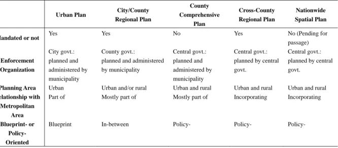
Characteristics and Potential Roles of Taiwan’s City/City/county regional plan
Taiwan’s city/county regional plan is characterized by composing of both urban and rural areas, being planned by municipalities, being mandated for deployment (Table 1). Its jurisdiction, mostly, is lying within a metropolitan area, or watershed. Due to this governance scheme, there is plenty of room for its potential roles.
Table 1 Characteristics of Taiwan’s Spatial Plans
Urban Plan City/County Regional Plan County Comprehensive Plan Cross-County Regional Plan Nationwide Spatial Plan Mandated or not Yes Yes No Yes No (Pending for
passage) Enforcement Organization City govt.: planned and administered by municipality County govt.:
planned and administered by municipality Central govt.: planned and administered by municipality Central govt.: planned by central govt. Central govt.: planned by central govt.
Planning Area Urban Urban and/or rural Urban and rural Urban and rural Urban and rural
Relationship with Metropolitan
Area
Part of Mostly part of Mostly part of Incorporating Incorporating
Blueprint- or Policy- Oriented
Blueprint In-between Policy- Policy- Policy-
Based on the characteristic that the city/county regional plan consists of both urban and rural area as a planning area, the central government is being able to implement urban growth boundary, and setting up development phases through the hand of county government. The county geographic scope allows possible spatial planning for the county spatial structure to where development goes. This planning system is better than the existing system in a few ways: the plan is conducted by those who know the area the best, rather than the central government and the planning board members who have limited knowledge for the area in question and time to devote themselves to. Then, the UGBs of smart growth have better be developed from a large scope, as opposed to one city alone. In particular, the GUBs certainly require plans in the rural area, such as preservation plans for agriculture land, watershed, forests, rather than thinking alone from development purpose and being given up to urbanizable area without overall vision of urban and rural area as a whole. And this probably requires legal position of the plan to implement reservation policy, rather than comprehensive plans without
authorization, which is subject to change due to political transition.
The development in the rural area can also be smartly managed in terms of location and priority. Rural sprawl, as opposed to clustered development, has been critical concern since the late 1990s when the regulation on the ownership of agricultural land was deregulated to cope with the impact of
Taiwan’s entrance to World Trade Organization. In the rural area, currently development projects are allowed through planning permission system, which is reviewed by regional planning committee board.
This current rural land use system is lack of an overall vision when granting or refusing
development project, which is likely to be better managed by city/rural regional plan in terms of where and when for development for sustainability purposes, for example. With urban growth boundary for the urban area and planning-permission system for the rural area, the overall spatial structure for the whole county can be formed. Through the countywide spatial planning, compact city and clustered development can be implemented in the land use sector.
The city/county regional plan is expected to function better than the conventional regional plan, county comprehensive plan, or city plan, in terms of resource protection since the it is characterized by a legalized plan with mandate to enforce its contents, containing both urban and rural areas where sprawl occurs, and in-between policy-oriented cross-county plan with planning flexibility and blue-print local plan with concrete planning vision. The resources that demand protection include environmentally sensitively areas, such as coastal areas (Deyle, Chapin, and Baker 2008; Norton 2005), agricultural land (Marin 2007), wetland, and watershed (Brody and Highfield 2005).
The city/county regional plan conserves the agricultural land in a more systematical, aggressive way, like shifting from proactively preserving agriculture land into actively recovering agriculture land in the frontier against urban expansion. This transition is largely attributed to the leadership of the central government, and the legal position of city/county regional plan, and the coverage of both urban and rural areas, allowing a more complete spatial plan for agriculture land.
The city/county regional plan, specifically characterized by being mandated by the municipality is new to Taiwan and hence is in the learning process. Its characteristics seem ideal theoretically in terms of implementing land use plan to guide development directly, strictly on the one hand, and with the flexibility of planning permission system. To shorten the learn curve, the central government has tried to learn from other countries, many of which, however, are nationwide spatial plans with different planning scope, such as The Netherlands. Hence, more preceding efforts in more similar format are still required, such as state plans in Oregon and California, USA, and territorial plans in Spain.
Planning Goals, Tools, and Sustainability
An essential planning process and method is the development of planning goals, based on which, objectives for achieving such goals are derived, and the actions to accomplish such objectives are developed. A common way for establishing the planning goals incorporate guidance from up-level plans, such as cross-city/county regional plan in the legal planning system, and plans or policies from upper-level government or within the county. Hence they may be common goals passed from the central government to the local municipality, such as growth management for current city/county regional plans; they may also be localized to fit into such local contexts as pro-development or
conservationists. What planning goals have been selected for the counties may at the very least reflect the what be happening in the region, jointly effected by needs and knowledge of the general public, entrepreneurs, politicians’ delicateness. Exploring planning goals of different counties, characterized into economic, environmental, and social sustainability and others may reveals what important common issues are missing.
In achieving planning ideals or goals, such as between sustainability and livability (Godschalk 2004), equality, and economic development, trade-offs often reigns that makes policy decision making a tug of war within and in between individuals and groups. This leads to two, at least, questions for scholars and practitioners: how significant is sustainability among planning ideals, and how can they be evaluated. The former concerns how sustainability ideal, the newly, widely adopted planning goal, has been implemented in practice; the latter raises a measurement issue in the research. In pursuing sustainability or smart growth, some components have been identified by smart growth enthusiasts as missing or underemphasized (Weitz, 2012), including land preservation (Daniels and Lapping, 2005).
Cross-examining planning goals against the socio-economic characteristics of the plan area may provide insightful explanation for the goals selected, but not necessarily. For example, cities or counties can be classified into growing, stable or declining status, each of which may lead to different goals to achieve. They may also be classified by the prominent industry. These socio-economic
characteristics mark the type and magnitude of activities required, and hence the more space needed or unneeded, and also the locations. In other words, they are one piece of fundamental information for land use plan.
It could be judgmental to comment on the goals of a city or county and difficult to stay totally neutral without a stand. However, policy implications based on the past experiences from the region and other areas may be a little more objective, convincing, and acceptable. In addition, what tools can help achieve the goals in fact is the key in the planning process since it might require plenty of hard work for the planners and officials to become totally aware.
The phenomenon of “sprawl” is attributed to a range of socio-economic, land use, transportation, financing causes. Land use factor affecting compactness/sprawl involves low-density zoning
designations, opportunistic development (Esparza and Carruthers, 2000), government-led expansion of new urbanizable land (Johnson and Schmidt, 2009). Low-density zoning, in essence, constitutes the “push-outward” force leading to suburban and exurban development, legitimating expansion of new urbanizable land in the city fringe or even rural areas, such as the case in the City of Sierra Vista in Cochise County, Arizona, USA (Esparza and Carruthers, 2000). Low-density zoning in the city, hence, contribute to the market demand for , suburban, exurban, or even rural development, providing or forcing (opportunistic) developers, politicians for out-stretching urban spatial plan; for example, a great many of small, home-rule municipalities in Weld County, Colorado, USA, annexing and flooding the market with new urbanizable land, have caused sprawl.
The strategies for promoting compact city or mitigation of “sprawl” involve recognition of sustainable urban form and the implementation policy and tools. The matrix of sprawl-reducing policies may include (Jabareen 2006) transfer of development rights, conservation easements, clustering, environmental mitigation/restoration, density bonuses (Brody, Carrasco, and Highfield 2006.), UGBs and transit-oriented development (Wheeler, 2008).
Several obstacles to implementing smart growth have been described (Costa 2005; Downs 2005), composed of general difficulty to operationalize, lack of involvement of planners and officials,
oppositions from stakeholders and citizens. In general, practical operation of sustainability to into concrete terms challenges planners and officials (Gunder, 2006). In addition, promotion of
sustainability may be remote (Chifos, 2007) for planners due to a variety of reasons, such as lack of planning expertise and enthusiasm, and planning ideology). In addition, a skeptical citizenry is another significant obstacle to achieving smart growth (Costa 2005). Opposition from stakeholders involves the conflicts of sustainability against political and economic interest groups.
The concrete terms of smart growth or growth management have been embodied in several regional plans, and in the first generation of county regional plans in Taiwan. In the US, several states have adopted state growth management programs, including Florida (Chapin and Connerly 2004), Washington (Brody, Godschalk, and Burby 2003), Maine (Inches and Vogt 2006; O’Connell, 2009), Oregon (Jun, 2008), and Maryland (Lewis, Knaap and Sohn, 2009). Maine’s experience shows a positive role of state-mandated comprehensive planning requirements that it is positively associated city adoption of smart growth policies (O’Connell, 2009). This may work in the way that the local plans adopt it as a planning guidance if local planners and officials are lack of these planning ideals, expertise, or enthusiasm. The famous Portland region urban growth boundary has been remarkably effective at reducing rural sprawl in the Oregon portion of that metropolitan region (Wheeler 2008b). However, the implementation problems of the state of Maryland’s approach to urban containment known as priority funding areas (PFAs,) have led them to fall well short of expectations (Lewis, Knaap and Sohn, 2009). However, growth management system does encounter dilemma is Florida, gaining less public support among citizens between 1985 and 2001 (Chapin and Connerly 2004).
An alternative planning twist, as opposed to smart growth, is smart decline (Hollander, and Németh 2011) and slow growth (Gainsborough 2002) management, which may need to be paid more attention in the coming decades for certain areas or even countries. It could be not unfair to say that conventionally people are educated through official and non-official education to welcome growth, as reflected in anxiety due to decline of population, slow economic growth. The decline in population in certain areas has been going on for decades and seems uneasy to reverse, to be said in the least. In other word, it is a fact that the general public, planners, and politicians have to face, which however, has not been an easy job. It goes without saying that the merits of decline of population have been overlooked widely, such as the long-time trend of deceiving green territory being primarily caused by growing population and economic growth. In some cases slow-growth policies appears to be
increasing receptive such as suburban areas of New York, Los Angeles (Gainsborough 2002) and New Jersey, where quality-of-life receive more popularity than growth, which was even regarded as threats (Schmidt 2008).
Methods
To evaluate the potential quality of Taiwan’s developing city/county regional plans in general, and adoption of smart growth ideal in specific, as well as the potential causes that affect the quality,
literature review, plan quality evaluation, and interview will be applied. The data sources for
conducting plan quality evaluation contain the latest technical reports or documents of regional plans at all phases of all counties in Taiwan, which are detailed below.
Two crucial groups of required data are depending on the literature review: the contents that should be incorporated in a city/county regional plans and methods of evaluating plan quality. The former plays the role of “standard elements and format” of a “sound” regional plan, and the latter assess the developing plans.
Plan quality evaluation, which is an emerging methodology for assessing the plans (Berke, and Godschalk, 2009) will be applied to the analysis on plan content. Based on the literature review above, the dimensions (such as socio-economic characteristics of the region, political support, and resource commitment) and sectors (e.g., land use, transportation, and agriculture) that are appropriate or should be covered in the city/county regional plan, political support, and the principles and criteria (such as sustainability, smart decline), the analysis framework is developed, possibly including a list of evaluation items and criteria.
This study, based on the current best results from the literature, will stand on the shoulder of an analysis framework proposed for land use plans by Berke, and Godschalk (2009) and Baer’s (1997) general criteria for plan assessment for during plan making process. Two conceptual dimensions suggested by Berke and Godschalk (2009) are to be included in the plan quality evaluation: (1) internal plan quality that contains the content and format of key components of the plan (e.g., issues and vision
statement, fact base, goal and policy framework) needed to direct land use in the future, and (2) external plan quality that covers the width of the scope and stakeholder values, and the local situation to maximize function of the plan. Given the above two dimensions, Baer’s general criteria will be cross-tabbed and broken down, containing adequacy of content, “Rational Model” considerations, procedural validity, adequacy of scope, guidance for implementation, approach, data, and methodology, quality of communication (Table 2).
Table 2 Characteristics of Plan Quality That Serve as Evaluation Criteria for Taiwan’s City/County Regional Plan
Internal characteristics
Fact base
Present and future population and economy
Existing land use and land supply, and future land demands for various uses (e.g., housing, commercial, industrial, public facilities)
Existing capacity and future demand for public infrastructure State of natural environment resources and constraints Issue identification
Description of major opportunities for and threats to desirable land use and development Assessment of major issues, trends, and impacts of forecasted change
Vision, Goals and Policies
A vision that identifies what the community wants to be
Statements of future desired conditions that reflect breadth of community values Sufficiently specific (not vague) to be tied to definite actions
Spatial designs that specify future land use, infrastructure, transportation, and open space networks that are sized to accommodate future growth
Implementation: Timelines for actions
Organizations identified that are responsible for actions Sources of funding are identified to supporting actions Monitoring and evaluation:
Goals are based on measurable objectives Indicators of objectives to assess progress
Internal consistency: Issues, vision, goals, policies, and implementation are mutually reinforcing Goals must be comprehensive to accommodate issues and vision
Policies must be clearly linked back to goals and forward to implementation actions
External characteristics
Interorganizational coordination:
Vertical coordination with plans or policies of federal, state, and regional parties
Horizontal coordination with plans or policies of other local parties within or outside local jurisdiction Compliance: Consistent with the purpose of plan mandates
Required elements are included in plan Required elements fit together
To probe the reasons for the high and low quality of regional plans, interview on stakeholders of the development of the plans will be conducted. Interview guidelines on the aspects of the above internal and external characteristics will be developed for the interview. The stakeholders of the development of the regional plan contain officials at the county and central governments, planners of the planning consulting firms involved in developing city/county regional plans, committee members of the plan review board, etc.
The major data sources for the plan quality evaluation will be composed of the technical reports or other related documents for all counties receiving financial support from Taiwan’s Ministry of Interior (內政部營建署,2012) for years 2010, 2011, 2012, and the coming 2013 for developing their own city/county regional plans. Each of these years, a few counties are granted for up to nine million NT dollars or some US$300,000. The progress of counties for the 2010 counties is almost close to the final stage of finishing their technical reports.
New County/City Regional Plans
What initiates the new spatial planning system-county/city planning composed of both urban and rural areas? The new mandated city region plans are mandated for almost 18 of the 20 first-level municipalities in Taiwan, except for the capital Taipei and Chia-yi city, composed five so-called
“direct” cities, 14 counties and cities, governed by elected mayors. The territory of most of 18 counties and cities are like city-region, composed both urban and rural areas.
What have been changed in the planning system--shift of power structure and decision making for city-region spatial planning from central government to highest level of autonomous government- city and county. Over the past few decades since both rural and urban areas were incorporated in the spatial planning system in Taiwan since the 1960s (?), the planning, decision making of city plans within the highest-level of municipality-county and city, have been designated to county and city. Nonetheless, the rural area within their jurisdiction, that is the areas outside of the urban areas, have been majorly under the control of central government; only the development less than 30 hectors are commissioned by the central government to the county government. At the inauguration of the city/county based regional plan, composed of urban areas and rural areas as a complete spatial planning unit, the
planning, decision making, and power is designated to the city or the county. The roles of the city and county include planning, and reviewing land use change, which used to be controlled by the central government; the roles of the central government focus on developing general policies, coordinating cross-county/city planning, and supervising special cases.
What are being/expected to be improved-General civil participation movement, awareness of environment protection and the internet social media era jointly bring the new, direct, wide,
overwhelming public participation in overviewing of development of county/city regional plan. For both the development of new plan and reviewing of existing plan, the ways of public participation in spatial planning system have evolved dramatically in the past few years, particularly after the so called “318 Sunflower Event,” in which tens of thousands of university students occupied the paramount and the surrounding areas in Taipei, Taiwan for some 23 days since March 18, 2015 majorly protesting the bill regarding a business accord between Taiwan and China. This movement was driven largely from the distrust of the government and the legislature system, and request for the direct participation of civil rights. After this movement, direct participation in public affairs have been demanded, with internet social media, such as Facebook, Line, and PTT as a major platform to exchange opinions and real time summon for occupation, protest activities, and real time self-broadcast media. After the so-called Sunflower event, a similar large scale students protest happened in Hong Kong, i.e., the so-called Umbrella Revolution.
In the wake of new type of public participation in public affairs, non-government organizations and the general public, particularly the internet populations are more used to take advantage of the internet social media to form pressure to the government with higher interest of public affairs,
willingness of opinion expression, possibly due to unanimous status, easier collection of public opinion. Reporters nowadays start to report with hot opinions with high number of discussions or agreements, to certainly degree reflecting the popular topics and alternative result of real time poll. This direct, overwhelming public participation has shown great power in affecting the old decision making system in spatial planning system, including the county/city-based regional plans.
First of all, all the documents, including planning reports, information on the meeting of planning boards, minutes of meetings have been required to be put on line. Second, the general public is
allowed to audit the board meetings or even express opinions in some cases. With the direct
participation, supervision of the planning process and content, the experts-based systems and to certain degree top-down planning decision making systems has been challenged. This progress is
revolutionary since the social cost of public participation was high that the possibility of large scale participation was slim. With this progress, the chair, usually the deputy mayor and board members have better sense of the public opinions, or are forced to face the pressures if they are contradictory. In short, the contradictory cases are less likely to be passed in the black box.
In addition, this public participation via internet usually gathers opinions from not only the residents but always whoever interested in the topic, which multiplies the pressure on the government when it is right.
The first-time mandated county/city-based regional plan:
The first-time mandated county/city region plan comprising all urban and rural areas requires the first-tier to municipalities to develop a county/city-wide regional plan, incorporating long-time
neglected rural areas into a complete spatial plan. This new system differs from the existing system in a few aspects. First, the existing mandated regional plan system in Taiwan split Taiwan island into four parts, North, Central, South, and East regions, under which, there is lack of long-term, mandated regional plan for elected mayors to carry out accordingly, or revise if necessary. The existing regional plan provides only policy or guidelines for the local government without spatially specific vision or plans. Secondly, even though many mayors may develop their non-mandated county/regional
comprehensive plans during their terms, they may not be adopted by the successors when the stepping down. As a result, the comprehensive plans are more like the “white paper” for the existing mayors, rather than the long-term plan. Thirdly, the contents of the non-mandated are made without guidelines provided by the central governments, hence, significant issues being neglected are quite normal.
The 18 county/city regional plans jointly constituting the national spatial plan:
The national spatial plan bill has been not being passed for decades primarily for such political reasons as rigid land use control over vast land in the rural areas, which occupies over 80 percent of the surface of Taiwan. Consequently, the bill has been facing obstacles in the paramount, i.e., the
Legislative Yuan, in Taiwan. As an alternative to get around this serious issue, particularly the spatially environment sustainable plans, the new county/county regional plans have been adopted to embed the fundamentals and spirit of the national plan, which may not be as complete as national plans, but, as a whole, can be regarded as version zero of the national spatial plan of Taiwan.
The whole area within a first-tier municipality being planned/developed by entity itself-Local autonomy:
The contents of the new county/city regional plan improve the existing plans due to a complete spatial area in a number of aspects. First, for the first time, the municipalities of highest level have the mandate to develop their own spatial plan for the whole territory. The existing system of cross-county regional plans, as a comparison, are policy-oriented as a nature of such a large-scale plan, which is not suitable to provide a blue-print plans, possibly necessary for certain occasions. Second, the existing cross-county regions plans were developed “out-siders,” that is the central government, who logically, practically, and truly are not familiar with the county or city, as the mayors, and local planners. As a result, the cross-county regional plans can only scratch the skin but cannot serves the true local needs. Furthermore, the new county/city plans, for the first time, are mandated to plan for the rural areas, which in this country used to comply with the existing land use, rather than a plan. The new regional plan are mandated to plan for all urban areas as a whole, and the surrounding rural areas, which requires the municipality to plan more complete in terms of longer period of plan, more complete sectors as a whole from the local eyesight. This progress corrects the old non-mandated county regional plan, which used to be biased into development-oriented, with less attentions to what the mayors are less attentive to due to the political concerns. This local developed, enforced, managed plan is like customized and hence superior in terms of serving its needs, with better feasibility, with better right-and-responsibility structure, reflecting the spirits of self-autonomy.
Clear spatial guidelines for public projects and private investment:
The new county/city regional plan provides clear land use vision within the county/city boundary showing on the map, though at small scale, i.e., 10,000 to 1. These spatial guidelines are significant in directing spatial development for both public and private development through both where all types of developable land are preferred or located, and where are prohibited or without the possibility of being issued development right permission in the rural areas, such as environmentally sensitive areas. In this way, both public projects and private investment have clear and strong spatial guidance, and hence misguidance on spatial investment can largely be avoided, and the investment process can be expedited. Under the clearer county-wide blue-print guidance, all the urban plans can be revised or newly developed, with a better overall vision to follow. Any spatial plans of other non-spatial-planning sectors, such as transportation, entertainment, can also benefit from it by the same token. As a result, the future development will most occur at the designated location, other than some special cases with special permissions, and urban and rural forms will be developed in a more compact form, rather than
current form without vision in the rural areas.
Blue-printed county/city regional plan when necessary and possible:
The existing cross-county regional plans only provide vision graphics without detailed blue-print possibly because its spatial scope is too large to do so. Blue print is significant in providing clearer spatial guidance for both private investment and public projects to avoid misguided investment or plans. So, the current version of county/city regional plans has been advised to provide blue print at a reason spatial scale. For conditions that blue print is impossible, policy-oriented displayed in words are applied.
Full-scale adoption of growth management in city/county regional plan leading to a nationwide application:
Some of the growth management measures have been applied in the urban area through planned population size. It is not until the new county/city regional plans that full-scale application of growth management is applied at both urban and rural areas, covering the whole country. The measures
applied include, first incorporation of environmental capacity cap, such as water, electricity supply into each of county/city region plan; also with the population and employment forecast, i.e., the future fundamental demand, the capacity cap and demand forecast jointly contribute to the planned population size with growth management essence. Secondly, urban growth boundaries for all urban plans are developed. Thirdly, the development priority to cope with future needs are developed into four phases with infill development as first priority, followed by the agricultural parcels with urban areas, expansion of urban areas, and finally the designated rural areas. The expansion of urban areas is only permitted when the used urban area has reached %.
With the growth management measures, the frequent, inappropriate urban sprawl via expansion of urban areas, in many cases, can be mitigated to certain degree. Ironically, some serious urban sprawl phenomenon is systematically caused by the mayors or local councilors. For example, a new aero-polis new town called Taoyuan aero-polis, has been promoted by the central and local government, which however causes not only urban sprawling issues since many surrounding urban areas still have vacant land for further development but also societal conflicts since, for example, many villages have been forced to move without fully justified reasons. This type of inappropriate development needs to be scrutinized in great detail with long-term development of the area as the context.
Full-scale nationwide protection of environmentally sensitive land:
Even though environmentally sensitive land in many aspects, including geological, biological, cultural fields, has long being protected one way or another, many grey areas exist. This new
land, in particular those with all kind of barriers that have been left behind or avoided. As a matter of fact, this is actually the emphasis that initiates this new regional plan. What have been incorporated include protection of first-grade (most suitable) agricultural land from being converted into developed land use, protection of watershed for collecting drinking water, reservation of territory for more than ten indigenous peoples, and some specific geologically sensitive areas that have been developed for agriculture and recreation. It is not that they were not paid attention to, or lack of law to protect, but due to long-time historical facts, quality of people, bureau, political pressure from interest groups, conflicts of laws, conflicts among agencies, such as drinking water protection and recreational development to boost local economy, lack of accurate spatial data, lack of budget to compensate loss of land owners among others. These issues may exist for both urban and rural areas.
A formation of platform for coordination between interest groups for resolving conflicts and coordination for use of land:
For the urban and rural planning made possible by the county/city regional plan, a platform for coordination is formed since various meetings at different phases of the planning, reviewing process are required to hold. In which various stakeholders have the opportunities to sit together to express, exchange, and discuss their opinions under the same roof, on the one hand. On the other hand, issues of concern sooner or later along the process are likely to be brought up and discussed, and resolutions are attempted to be developed to reach consensus. The coordination can occur among government, non-governmental organization (NGO), the general public, and exports or scholars, between central government and local governments, and between agencies of the county/city government. The type of coordination mostly involves conflict of use of land among stakeholders, and cooperation between stakeholders for use of land.
Shifting role of land use management into land use planning in the rural area, jointly with urban areas:
In the past, the counties or cities are not required to develop an overall plan for the rural areas, and hence they simply manage rural land use basically according to what had been there and with the decision power on issuing permission for development right. Only those aggressive mayors develop county/city comprehensive plan during their elective term, which however usually are mandated hence their planning foundation are suspected since their normally reflect what the mayors what to do, not based on a complete process soliciting opinions from all possible stakeholders, among others. Hence, they are likely to be dropped when their term is over. The new county/city regional plan shifts the role of the county/city government from land use management only into also involving a complete future vision, blue prints wherever possible and necessary, and action plans. With the spatial guidance, the land use management tasks have directions to follow, rather than the existing disintegrated relationship among land uses, and city plans within the county/city territory.
Public understanding, involvement, and participation in county/city, particularly rural area, regional planning being possible now:
Other than the county/city mayors, planners, committee, some invited exports and scholars and other some very limited number of related persons, there is few persons or groups that have the opportunities to be part of the county/city related plans if there is any, or even worse there is none for many counties/cities. With the current, new county/city regional plans, it is mandatory for the agency in charge of county/city regional plan to provides all related meeting information, minutes, reports, public hearing and like, and auditing rights into review process to the public. In this way, at the very least, the general public, NGO, council members, and whoever interested, have the channels and opportunities to understand, participate in the plans at all phases, such as opinions collection, planning, evaluation processes. Or it could be even better planners could involve whom they deem beneficiary to the plan in developing the plan to best serve the real needs from all possible stakeholders. The quality of the plan is very likely elevated in this way in terms what the society and environment needs, how they need, and to what extent they need, and to avoid or minimize mistakes that could be made.
What are the challenges?
Lack of sufficient “carrots” and “sticks” to implement the new county/city regional plan:
One significant issue that fundamentally affects the progress of the new county/city regional plans is the municipalities and developers are not provided with incentives to expedite the process, nor is the existence of punishment system when they are behind. This is particularly true since the
constraints-related policies are the primary objectives, such as growth management and protection of environmentally sensitive land preventing more developable land and hence reducing tax revenues, stimulating political pressures from pro-development stakeholders. The situation is worsened since tons of new, extra, long-term tasks for planning, negotiation, and legalization have been created for the planning related civil servants. One case regarding the incentive for the planning bureau of
municipality is the expedition in the legal process for legalization of new or expanding urban plans can make significant time saving; nonetheless, the so called “development-oriented land,” a special type of land use in the rural areas, designated for future development in the plan where permission for
development can be granted in a shorter period of time, actually can only save about one month for developers which is suspected unattractive incentive.
Concern about elevated housing prices due to growth management due to less developable land; Developing, adjusting policies of the central government cause staggering response in the municipality:
The current the county/city regional plan is the first version wherein some policies of them can be adjusted in the future since this is the first try in the country. Inevitably, many municipalities are in the
circumstance of wait and see.
Pressure from counties/cities to raise planned population size to set higher amount of developable land:
One fundamental tool of growth management is set a population, employment, or tourist cap based on the supply constraints and growth forecast, based on which the amount of developable land of all kinds are calculated accordingly. Population or employment cap hence is aggressively
challenged by the municipality to set up higher gap, or on the contrast, softly and implicitly challenged by them with the similar request. The demand for higher population, employment, or tourist cap
largely is due to the enlarging the tax base, with which counties or cities can provide more services and constructions for general public and entrepreneurs, affecting their next election either for individual or the party. The wake of the pressure is massive since the civil servants are facing the elected mayors, representing their electors. This totally endangers the success of growth management. As a result, urban sprawl may occur or worsen due to system per se if the cap is overset; that is the growth management is challenged by the government itself.
The geographic information data on fundamental environmentally sensitive land being incomplete, inaccurate, inaccurate for come layers:
The underlying support for planning for environmentally sensitive land is great deal of geological, biological, cultural data shown on GIS layers with necessary details. These data have been developed by the governments since the 1990s in Taiwan, however, it is still in the process and needs some more time to have a more complete data set, whose accuracy level and errors are acceptable.
Conclusions and Policy Implications
The preliminary research results show, first, growth management related policies have been widely implemented and expected to have effective impact, including incorporating resources capacity to determine maximum population for the city region as a whole, developing overall vision of urban growth boundary for all the whole city region, prioritizing infill development, and use of architectural land within urbanized area over rural area to cope with urban growth. Secondly, planning-oriented zoning is adopted in urban areas, while demand-oriented planning permission is applied in the rural areas with designated plans. Then, public participation has been evolved to the next level to oversee all of government’s planning and review processes due to the decreasing trust in the government, and development of public forum on the internet etc. Next, fertile agricultural land is preserved to maintain food self-supplied goal for national security concern. More adoption-based methods than
mitigation-based methods have been applied to cope with global climate change. Finally, better land use and transportation planning in terms of avoiding developing rail transit stations and corridor in rural area is promoted.
Even though many promising, prompt measures have been adopted, however, challenges exist to surround: first, overall urban density, likely affecting success of UGB, or use of rural agricultural land, has not been incorporated, possibly due to implementation difficulties. Second, land-use related measures to mitigating climate change seem less clear and hence less employed. Smart decline has not drawn enough attention to cope with predicted population decrease in the next decade. Then, some reluctance from county’s government to implement county regional plan can be observed vaguely possibly since limits have be set on further development on agricultural land and sensitive areas. Finally, resolving issue on existing illegal factories on agricultural land remains the most challenging dilemma.
References:
Berke, Philip R., and Maria Manta Conroy. 2000. ‘‘Are We Planning for Sustainable Development? An Evaluation of Thirty Comprehensive Plans.’’ Journal of the American Planning Association 66 (1): 21–33.
Berke, Philip, and David Godschalk. 2009. ‘‘Searching for the Good Plan: A Meta-analysis of Plan Quality Studies.’’ Journal of Planning Literature 23 (3): 227–40.
Brody, Samuel D., and Wesley E. Highfield. 2005. ‘‘Does Planning Work? Testing the Implementation of Local Environmental Planning in Florida.’’ Journal of the American Planning Association 71 (2): 159–75.
Brody, Samuel D., Virginia Carrasco, and Wesley E. Highfield. 2006. ‘‘Measuring the Adoption of Local Sprawl: Reduction Planning Policies in Florida.’’ Journal of Planning Education and Research 25 (3): 294–310.
Brody, Samuel D., Virginia Carrasco, and Wesley E. Highfield. 2006. ‘‘Measuring the Adoption of Local Sprawl: Reduction Planning Policies in Florida.’’ Journal of Planning Education and Research 25 (3): 294–310.
Chapin, Timothy S., and Charles E. Connerly. 2004. ‘‘Attitudes towards Growth Management in Florida: Comparing Resident Support in 1985 and 2001.’’ Journal of the American Planning Association 70 (4): 443–52.
Costa, Fernando. 2005. ‘‘Comment: An Ambitious Movement and its Prospects for Success.’’ Journal of the American Planning Association 71 (4): 378–80.
Daniels, Tom, and Mark Lapping. 2005. ‘‘Land Preservation: An Essential Ingredient in Smart Growth.’’ Journal of Planning Literature 19 (3): 316–29.
Deyle, Robert E., Timothy S. Chapin, and Earl J. Baker. 2008. ‘‘The Proof of the Planning is in the Platting: An Evaluation of Florida’s Hurricane Exposure Mitigation.
Downs, Anthony. 2005. ‘‘Smart Growth: Why We Discuss It More Than We Do It.’’ Journal of the American Planning Association 71 (4): 367–78.
Edwards, Mary M., and Anna Haines. 2007. ‘‘Evaluating Smart Growth: Implications for Small Communities.’’ Journal of Planning Education and Research 27: 49–64.
Esparza, Adrian X., and John I. Carruthers. 2000. ‘‘Land Use Planning and Exurbanization in the Rural Mountain West: Evidence from Arizona.’’ Journal of Planning Education and Research 20: 23–36. Gainsborough, Juliet F. 2002. ‘‘Slow Growth and Urban Sprawl: Support for a New Regional
Agenda?’’ Urban Affairs Review 37 (5): 728–44.
Godschalk, David R. 2004. ‘‘Land Use Planning Challenges: Coping with Conflicts in Visions of Sustainable Development and Livable Communities.’’ Journal of the American Planning Association 70 (1): 5–13.
Gunder, Michael. 2006. ‘‘Sustainability: Planning’s Saving Grace or Road to Perdition?’’ Journal of Planning Education and Research 26: 208–21.
Hollander, Justin B., and Jeremy Németh. 2011. “The Bounds of Smart Decline: A Foundational Theory for Planning Shrinking Cities.” Housing Policy Debate 21(3): 349-367.
Inches, Sue, and Jay W. Vogt. 2006. ‘‘Renewing Growth Management in Maine.’’ Practicing Planner 4 (4).
Johnson, Katherine M., and Charles G. Schmidt. 2009. ‘‘Room to Grow: Urban Ambitions and the Limits to Growth in Weld County, Colorado.’’ Urban Affairs Review 44 (4): 525–53.
Jun, Myung-Jin. 2008. ‘‘Are Portland’s Smart Growth Policies Related to Reduced Automobile Dependence?’’ Journal of Planning Education and Research 28 (1):100–107.
Knaap, Gerrit, and Emily Talen. 2005. ‘‘New Urbanism and Smart Growth: A Few Words from the Academy.’’ International Regional Science Review 28 (2): 107-118.
Lewis, Rebecca, Gerrit-Jan Knaap, and Jungyul Sohn. 2009. ‘‘Managing Growth with Priority Funding Areas: A Good Idea Whose Time Has Yet to Come.’’ Journal of the American Planning Association 75 (4): 457–78.
Marin, Mehmet C. 2007. ‘‘Impacts of Urban Growth Boundary versus Exclusive Farm Use Zoning on Agricultural Land Uses.’’ Urban Affairs Review 43 (2): 199–220.
Norton, Richard K. 2005a. ‘‘More and Better Local Planning: State-mandated Local Planning in Coastal North Carolina.’’ Journal of the American Planning Association 71 (1): 55–71.
Robert E., Timothy S. Chapin, and Earl J. Baker. 2008. ‘‘The Proof of the Planning is in the Platting: An Evaluation of Florida’s Hurricane Exposure Mitigation Planning Mandate.’’ Journal of the American Planning Association 74 (3): 349–70.
Saha, Devashree, and Robert G. Paterson. 2008. ‘‘Local Government Efforts to Promote the ‘‘Three Es’’ of Sustainable Development: Survey in Medium to Large Cities in the United States.’’ Journal of Planning Education and Research 28:21–37.
Schmidt, Stephan. 2008. ‘‘From Pro-growth to Slowgrowth in Suburban New Jersey.’’ Journal of Planning Education and Research 27: 306–318.
Weitz, Jerry. 2012. “Growth Management in the United States, 2000–2010: A Decennial Review and Synthesis.” Journal of Planning Literature 27(4): 394-433.
Wheeler, Stephen M. 2008a. ‘‘State and Municipal Climate Change Plans: The First Generation.’’ Journal of the American Planning Association 74 (4): 481–96.
Wheeler, Stephen M. 2008b. ‘‘The Evolution of Built Landscapes in Metropolitan Regions.’’ Journal of Planning Education and Research 27 (4): 400–416.
內政部營建署,2012內政部補助地方政府辦理直轄市、縣(市)區域計畫規劃--內政部補助經費一覽表。
行政院國家科學委員會補助專題研究計畫
■ 成 果 報 告
□期中進度報告
台灣直轄市、縣(市)區域計畫的功能與挑戰
Functions and Challenges of New County-based Regional Plan in Taiwan
計畫類別:■ 個別型計畫 □ 整合型計畫
計畫編號:NSC 102-2410-H-004 -199
執行期間:2013/08/01~2015/07/31
計畫主持人:蔡育新
共同主持人:無
計畫參與人員:張懿萱、鍾佾芯
■出席國際學術會議心得報告及發表之論文各一份
執行單位:國立政治大學地政學系
1 (五)附件:出席國際學術會議心得報告 報告人姓名 蔡育新 服務機構 及職稱 國立政治大學地政學系 教授 時間 會議 地點 2015/04/08~2015/04/09 阿拉伯聯合大公國杜拜 (Dubai,UAE) 本會核定 補助文號 計畫編號: NSC 102-2410-H-004 -199 流水號: 102WFA0200409 會議 名稱 (中文)
(英文) International Conference on Urban Planning, Regional Development and Information Society
發表 論文 題目
(中文) 台灣直轄市、縣(市)區域計畫的功能與挑戰
(英文) Functions and Challenges of New County-based Regional Plan in Taiwan
2 報告內容: 一、參加會議經過 個人於會議議程開始前數日,即先抵達阿拉伯聯合大公國的杜拜,除了開會兩天外, 並利用其他時間進行都市規劃與設計探訪。研討會期間,除第一日發表論文外,另參加大 二相關領域的論文發表,並與數位發表人交換心得。 二、與會心得 此國際會議參與人數、發表論文的質與量,屬與中小型國際會議,但因會議位於中東, 因此參與的國際學者背景相當多元,是個人過去較少有的經驗。於會議中與不少國際專家 學者進行學術交流與意見交換,除獲得專家學者對個人發表論文的建議外,另對於來自非 洲與印度的學者有一手的接觸,相當難得,也對於目前第三世界的發展有較稍微深入的體 驗。 除此,杜拜是目前國際上少數 New Town 成功的案例,且其規模非常龐大。其於都市 規劃、設計、觀光產業,都有提昇至下一個層級的呈現。除此,著名的未來永續都市 Masdar City(建造中),是當前世界上最前衛的綠色都市案例之一。個人藉此會議也順道蒐相關 集資料與參訪,當做上課教材與研究參考。 三、攜回資料名稱及內容
Conference Proceedings of International Conference on Urban Planning, Regional Development and Information Society.