行政院國家科學委員會專題研究計畫 成果報告
台灣與菲律賓的地體動力學研究--Taal 湖以及周邊地區地
球化學系統研究:重建菲律賓中部全新世以來古氣候和火
山噴發歷史
研究成果報告(精簡版)
計 畫 類 別 : 整合型 計 畫 編 號 : NSC 97-2628-M-006-014- 執 行 期 間 : 97 年 08 月 01 日至 98 年 07 月 31 日 執 行 單 位 : 國立成功大學地球科學系(所) 計 畫 主 持 人 : 李紅春 計畫參與人員: 碩士級-專任助理人員:陳雪姿 碩士班研究生-兼任助理人員:郭子興 碩士班研究生-兼任助理人員:李仲弘 大專生-兼任助理人員:李宗翰 博士班研究生-兼任助理人員:萬乃容 博士後研究:溫大任 報 告 附 件 : 出席國際會議研究心得報告及發表論文 國際合作計畫研究心得報告 處 理 方 式 : 本計畫可公開查詢中 華 民 國 98 年 10 月 31 日
行政院國家科學委員會專題研究計畫
研究成果報告
Taal 湖以及周邊地區地球化學系統研究:重建菲律賓中
部全新世以來古氣候和火山噴發歷史(2/3)
計畫類別:一般型研究計畫(個別型) 計畫編號: NSC 97-2628-M-006-014 執行期間: 97 年 08 月 01 日 至 98 年 07 月 31 日 執行單位: 國立成功大學地球科學系(所)計畫主持人: 李紅春
報告類型: 精簡報告 報告附件: 出席國際會議研究發表論文 處理方式: 本計畫可公開查詢 中 華 民 國 98 年 10 月 31 日一. 中、英文摘要及關鍵詞 本年度研究計畫執行期間為民國97.8.1-98.7.31,目的是通過對菲律賓Taal火山湖進行系統地地 球化學研究,重建全新世以來Taal火山的噴發歷史,瞭解研究地區的古氣候和古環境變化。 主要完成工作有:(1)2008年6月23-26日到Taal湖選擇岩芯鑽探位置並進行野外採樣,與菲律 賓火山地震所的學者和鑽井公司的技術人員討論鑽井細節和時程。(2)對Taal湖水樣和重力 岩芯樣品的空隙水進行元素與同位素分析。(3)對岩芯TLS1進行進一步的AMS 14C定年。(4) 對TLS1和TLS2進行常量、微量元素進行測量。(5)取得鑽井深度為84米,岩芯長度為64米的 沉積物層序,運回臺灣後進行樣品切割整理、岩性剖面描述等,並分層取樣,準備地球化學 分析。由於利用核爆14C曲線確定了過去60年來Taal火山湖的沉積年齡,我們對比了地球化學 指標的變化與火山活動事件,發現了一下有意義的結果:(1) 通過對Taal火山湖地球化學體系 的研究,我們認為d18O, Fe, Mn, K, Cu是幾個監測火山活動的重要參數。(2) 在過去60年的湖 泊沉積岩芯發現了1991年的強烈活動時間,與Pinatubo火山噴發同時間,指示Taal和Pinatubo 之間的聯繫。(3) 碳酸鹽相的δ18O和δ13C與湖水的δ18O和δ13C有平衡分餾,δ18O反映湖水水文
受地表水和地熱水輸入的影響,而δ13C則反映湖泊的生產力的變化。當火山活動異常時,這 兩個指標均呈現異常。(4) 有機碳δ13C 變化與有機碳含量(TOC)呈反相關,而與C/N比值呈正 相關。這表明湖周圍的有機碳輸入對沉積物中有機碳的影響。這三個指標的組合反映湖泊生 態系統的變化。(5) 2004年以來,上述火山活動指標明顯增加,可能預示近期強烈噴發的可能 性,值得密切監視。 關鍵字:Taal 火山,湖相沉積物岩芯,AMS 14C 定年,岩芯物理化學性質,穩定同位素,微 量元素
This project is one of the subprojects under a 3-yr intergraded project: Geodynamics of Taiwan and the Philippines. We attempt to find out geochemical proxies of volcanic eruptions and to reconstruct Holocene volcanic activities recorded in the Taal lake sediments by a systematic study on geochemistry of Taal Volcano in the central Philippine. In the second year of this project, we have done the following works: (1) conducted fieldworks for investigation the drill core site at Taal Lake during June 23-26, 2008. (2) Sampled and measured waters of Taal Lake and porewater samples of major and trace elements. (3) Obtained more AMS 14C dates on core TLS1. (4) Measured major and trace elements in acid-leachable components of the lake sediments form the gravity cores TLS1 and TLS2. (5) Drilled a 64-m long core with the total depth of 84 m on the western shore of Taal Lake. After the core materials were shipped back to NCKU, we have cut the cores, described the core logs, sedimentary features, and subsampled the cores. Based on the bomb-14C curve measured in the gravity core TLS2, we have established a very reliable chronology of the 60-yr depositional history of Taal Lake. With the detailed analyses of stable isotopes and trace elements in the core, we concluded that: (1) Among trace and heavy metal elements, Fe, Mn, Cu and Zn may be used as indicators of volcanic activity. (2) Acid-leachable Fe, Mn, Cu and K reveal anomaly high contents, reflecting enhanced geothermal inputs especially during the eruption of Pinatubo in 1991. These
elements may be indicators of volcanic activity. (3) Carbonate was precipitated in isotopic equilibrium with the lake water. The δ18O and δ13C of TIC reflect hydrological balance and lake
productivity, showing covariance. Volcanic activities around 1965, 1991 and 2006 led the δ18O and
δ13C anomaly. (4) The δ13C of TOC is negatively correlated with total organic carbon contents
(TOC) and positively correlated with C/N ratio. This means that the more TOC input from the surrounding area of the lake, the lighter δ13C of TOC will be. The combination of these three
proxies indicate changes in the ecosystem of the lake. (5) Several geochemical proxies show increased geothermal activities since 2004. Is the next eruption at Taal coming soon?
Keywords: Taal Volcano and Lake, lake sediment core, AMS 14C dating, physical and geochemical properties of the sediment core, stable isotopes, trace elements
二. 前言 菲律賓作為臺灣的鄰國,在構造活動、地震和火山災害、颱風事件等有著密切的關係。Taal Volcano 是世界上16 個被監測的最活動的火山之一,在此火山周圍有大量的人類生活,Lake Taal又是菲律賓之旅遊觀光區之一,火山噴發會對那裏的人類生命和環境產生嚴重的危害。 然而,Taal Volcano 的噴發週期和控制因素是什麼?它的噴發對氣候和環境變化有什麼影 響?菲律賓中部全新世古氣候和古環境的情況如何?這方面的研究在該地幾乎還是空白。利 用湖泊和近海沉積物中的地球化學資訊重建火山噴發事件是一個嶄新的科學思路,哪些指標 可以用來反映火山活動?如何獲取這些指標?這不僅對Taal Volcano 本身的研究具有意義, 也對整個研究古火山活動的理論基礎非常重要,並且對如何監測現代火山噴發的危險性具有 廣泛的實際意義。本計畫是台灣與菲律賓的地體動力學研究計畫的子計畫之一,通過對菲律 賓Taal火山進行系統地地球化學研究,重建全新世以來Taal火山的噴發歷史,瞭解研究地區的 古氣候和古環境變化。 三. 研究目的 本計畫目的是通過對菲律賓Taal 火山湖進行系統地地球化學研究,重建全新世以來 Taal 火山 的噴發歷史,瞭解研究地區的古氣候和古環境變化。通过調查Taal 火山湖各種水體和沉積物 的地球化學與同位素特徵, 測量沉積物岩心高解析度的特徵的地球化學元素與同位素,建立 沉積物岩心沉积记录的年代序列,對火山噴發的機制、古火山特徵指標、火山噴發與氣候變 化的互動、以及湖體環境變化提供重要的科學理論和應用基礎。 四. 研究方法 本計畫所採用的方法有:(1)調查 Taal 火山湖各種水體和沉積物的地球化學與同位素特徵; (2)採集 Taal 火山湖沉積物岩心,以210Pb 和14C 法定年,建立沉積物岩心的年代序列;(3) 測量沉積物岩心高解析度的特徵的地球化學元素與同位素;(4)計算 Taal 湖化學元素輸入通 量;(5)镜下分析沉积物的特性。 五. 研究成果
(A)AMS 14C 定年結果
我們在本年度的工作中對岩芯TLS1 進行了更多的 AMS14C 定年,由於樣品含植物殘體較少, 去年只有三個植物殘體樣品進行定年。本年度的樣品都是沉積物中的總有機碳,送到加州大 學爾灣分校的碳十四定年實驗室測試。結果如下表。
表1 岩芯 TLS1 總有機碳 AMS14C 定年結果
KECK CARBON CYCLE AMS FACILITY EARTH SYSTEM SCIENCE DEPT, UC IRVINE Sample ID UCIAMS 13
C ± Fraction ± ?14C ± 14C age ± Depth
(‰) Modern (‰) (BP) (cm) TLS1-A, ABA 47141 -31.3 0.15 0.9739 0.0013 -32.9 1.3 215 15 1.2 TLS1-02 61566 -26.76 0.9595 0.0016 -47.3 1.6 330 15 2.4 TLS1-10 61567 -24.21 1.0016 0.0016 -5.5 1.6 Modern 11.8 TLS1-13 61568 -25.53 0.9953 0.0020 -11.8 2.0 40 20 15.4 TLS1-20 61569 -26.88 0.9933 0.0016 -13.7 1.6 55 15 23.6 TLS1-25 61570 -25.20 1.0181 0.0017 10.9 1.7 Modern 29.5 TLS1-32 61572 -24.64 1.0157 0.0017 8.5 1.7 Modern 37.4
TLS1-AG, ABA 47142 -26.5 0.15 1.0170 0.0013 9.9 1.3 Modern 15 38.5 TLS1-43 61573 -23.97 0.8993 0.0015 -107.1 1.5 855 15 49.5 TLS1-52 61574 -24.59 0.8478 0.0015 -158.2 1.5 1325 15 59 TLS1-59 61575 -24.38 0.8514 0.0015 -154.7 1.5 1295 15 65 TLS1-63 61577 -24.60 0.8450 0.0015 -161.0 1.5 1355 15 69 TLS1-BM, ABA 47143 -25.5 0.15 0.8643 0.0012 -141.8 1.2 1170 15 72.0 Radiocarbon concentrations are given as fractions of the Modern standard, ?14C, and conventional radiocarbon age, following the conventions of Stuiver and Polach (Radiocarbon, v. 19, p.355, 1977) Sample preparation backgrounds have been subtracted, based on measurements of ABA treated
14C-free coal.
All results have been corrected for isotopic fractionation according to the conventions of Stuiver and Polach (1977), with 13C values measured on prepared graphite using the AMS spectrometer. These can differ from 13C of the original material, if fractionation occurred during sample graphitization or the AMS measurement, and are not shown.
13
C values reported here were measured on CO2 using Gas Bench coupled with IRMS (Finnigan Delta Plus).
從定年結果看,新測的這 10 個碳十四年齡基本反映了上年計畫中測定的三個植物殘體樣品 (-A, -AG, -BM)的碳十四年齡。這個從水深 100 米左右的地方採得的重力岩芯只有 76 公分 長,中下部的碳十四年齡卻達到1300 多年。然而,這個岩芯中部的沉積物年齡卻是現代的。 究竟這些碳十四年齡是受老碳的污染,還是受淺水沉積物與深水沉積物的混合,還需要進一 步研究。 (B)Taal 火山湖水系及沉積物稀酸可溶相的元素含量 經過對上百個水樣的分析測試,我們對Taal 湖以及周邊的各種水樣的化學組成有了詳細的瞭 解,選擇一些重要的元素在沉積物稀酸(1NHCl)相中進行測量,結果列於表 2。對於一些常 量元素來說,比如:Na, Ca, Mg, K, 元素雖然在地熱水中的含量很高,但在海水中也很高。由 於Taal 湖距海很近,海水對湖水的影響從下滲透和河水倒灌都已經有所發現,因此,不能以 這些元素做為地熱水增加的影響。另外,Si, B, Sr 的來源也較複雜,Sr 在海水中的含量高, 地熱水中的含量並不高,因此,Sr 含量不能做為地熱活動的指示,但 Sr 同位素是可以的。B 和Si 的含量,在湖水和地熱水之間的差別大約是 20-30 倍,如果地熱水的輸入不是很大量的 話,難以引起這兩個元素在湖水中的變化。 表 2 Taal 水系及沉積物稀酸可溶相的元素含量(ppm)
在表2 中,Fe, Mn, Zn, Cu 在湖水和地熱水之間的差別是幾百、上千倍,地熱水的貢獻對這些 元素在湖水中的含量有很強的影響。因此,可以這些元素來指示火山活動。在表中的稀酸可 溶相顯示,這些元素很容易被沉積物吸附,記錄湖水中這些元素含量的變化。 圖 1 稀酸可溶相元素的主要來源。 圖1 顯示稀酸可溶相的 Ca 含量與酸溶失重成強烈的正比關係,指示稀酸可溶相主要是沉積物 中的碳酸鹽。在這個相中,Sr 含量和 Ca 含量呈強正比,說明 Sr 與碳酸鹽共沉澱。而其他元 素都不在碳酸鹽相中,這些元素要麼吸附在有機物或細顆粒物質上,要麼存在於其他稀酸可 溶相礦物(如:禾樂石)。 對岩芯TLS2 的沉積物的稀酸可溶相測試結果進行分析,發現在 Fe, Mn, Cu, K 等含量升高的 時期(圖 2),對應於火山活動(或者地熱活動)較的時期,尤其是 1991 年 Pinatubo 火山噴發 的那一年,Taal 火山活動也很強烈,這在上述 4 個元素的含量變化都體現出來了。因此,我 們認為利用這些元素對火山活動進行監測,可以較早地發現火山活動的異常,進行危險性預 報。 (C) Taal 湖沉積物中穩定同位素記錄
圖2 TLS2 岩芯沉積物中幾種指示火山活動的地球化學指標
For this core, we have measured pore water content, weight loss by 0.5NHCl leaching, TOC, TON, δ18O and δ13C of TIC, δ13C of TOC, and concentrations of Na, K, Mg, Ca, Fe, Mn, Sr, Ba, Cu, Zn,
Pb, Li in the acid-leachable phase. The annual resolution δ18O and δ13C records provide us
detailed variations of the lake’s hydrological, biological and sedimentary history. Carbonate was precipitated in isotopic equilibrium with the lake water at ~30oC which is close to the measured water temperature. The δ18O and δ13C of TIC co-vary in the core, because of changes in surface
water input and geothermal input. In general, when there is more input surface water, both δ18O
and δ13C of the lake goes lighter due to dilution effect. The lake productivity at this time will be
lower, and carbonate precipitation is less. When the lake experiences less surface water input and/or more evaporation, δ18O and δ13C of the lake goes heavier due to the hydrological balance
and increased lake productivity. However, when the volcanic activity increases, significant amount of hydrothermal input and deep CO2 input will lead to increase of lake’s δ18O and δ13C. Both
圖 3 TLS2 岩芯沉積物中碳酸鹽相的δ18O 和δ13C 記錄
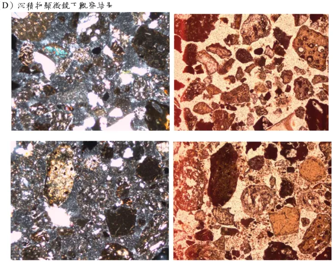
圖5 TLS2 岩芯沉積物中有機物的δ13C 和 C/N 比值 (D)沉積物顯微鏡下觀察結果
(E)64 米長的岩芯鑽孔整理 在 2008 年 10-11 月期間,本研究室溫大任博士在 Taal 湖紮住 40 餘天,監督岩芯鑽探進程, 幾乎每天和我在網上溝通,解決不斷出現的問題。我原來要求對方在湖面上鑽探,經過一周 的時間,鑽井公司在湖水面上搭了一個很大的鑽井平臺,將鑽機搬上,連續兩天鑽孔,都打 不上來沉積物,軟泥在鑽管出水時就流失貽盡。在換上專門從馬來西亞進口的 Core catcher 之後,還是無法解決問題。最後,我只好決定讓他們將鑽機搬到湖岸邊鑽孔。之後的鑽探效 率有所提高,然而取芯率仍然有低於 90%的狀況。經過三周的鑽探,鑽機在 84 米處,碰到井 壁垮塌,鑽機被卡住等困難,很難再往深出打井,鑽探工作結束。 在將岩芯運回臺灣的過程中,經過層層進口海關手續,終於在 12 月下旬運到成大。在後續的 整理、切樣、拍照和岩芯描述後,我們將岩芯風乾保存。但是,今年 8.8 水災時,存放岩芯 的倉庫泡水,部分岩芯受到影響。我們及時進行處理,並採樣。部分樣品送給菲律賓火山地 震所。目前正在進行岩芯的碳十四定年工作。 六. 計畫成果自評 以下列出計畫書中預期完成之工作項目及成果,並逐項對照給出執行情況: 98-99 年度
(1) Finish pore water samples for geochemistry and isotope analyses. 完成,詳見前面報告內容。
(2) Complete geochemical analyses for the sediment samples of gravity cores TLS1 and TLS2. 完成,詳見前面報告內容。
(3) Describing the 64-m long BH#2 core, making a complete core log and selecting dating materials from the core.
完成,詳見前面報告內容。
(4) Dating the sediments of core TLS1 and BH#2 with AMS 14C method.
部分完成。在本年度裏,對岩芯 core TLS1 增加了 10 個碳十四年齡,但可能是因為深 部沉積物有些來源淺水區,reworking 的作用導致年齡倒序。對 BH#2 岩芯樣品的碳十四定 年尚在進行中。
(5) Calibrating the dated geochemical variations of core TLS1 with the historic eruption events, finding the geochemical signals of volcanic eruption achieved in the sediments. Modeling geochemical budget of Taal Lake.
完成,詳見前面報告內容。
(6) Conducting partial geochemical analyses for the sediment samples from core BH#2. 正在進行。
(7) Using tephrachronology of the sediment cores to find out special events, frequency of eruptions.
這部分工作還未進行,主要因為 tephra layer 並不明顯。在 64 米的岩芯鑽井中,似 乎是幾次很大的噴發事件占主要的沉積厚度,需待定年之後才可以得到資訊。
students for their thesis studies. Training Philippine scientists in field and lab works, as well as research approaches. 完成。本計畫聘用溫大任博士,在 2009 年 10-11 月期間,溫大任在菲律賓監督 TAAL 湖岩 芯鑽探工作,取回 64 米沉積物岩芯樣品。在 2009 年 7 月,碩士生李仲弘和郭子興,分別 進行答辯,順利畢業。博士生萬乃容的論文也有所進展,目前已經投一篇 SCI 論文。在 2008 年的兩次野外工作,都是以菲律賓的人員參加為主,我對他們的鑽探和採樣技術進 行了指導。
(9) Writing progress report to NSC. Submitting 1-2 manuscripts to SCI journals.
完成,本報告書。同時,2009 年 9 月底前,已經有一篇 SCI 論文發表,一篇被接受, 正在刊印中:
Alexander A. Prokopenko, Mikhail I. Kuzmin, Hong-Chun Li, Kyung-Sik Woo, Norm R. Catto, 2009. Lake Hovsgol basin as a new study site for long continental paleoclimate records in continental interior Asia: General context and current status. Quaternary International, 205: 1–11. (SCI) (Impact Factor: 1.482; 5-Year Impact Factor: 1.938)
De’er Zhang, Hong-Chun Li*, Teh-Lung Ku, Long-Hua Lu, On Linking Climate to Chinese Dynastic Change: Spatial and Temporal Variations of Monsoonal Rain. Chinese Science Bulletin 54, doi: 10.1007/s11434-009-0312-2 (in press). (Impact Factor: 0.683)
另外有 4 篇做為第一作者和通信作者的文章投稿至 SCI 期刊:
Hong-Chun Li*, Zhong-Hong Lee, Nai-Jung Wan, C.-C. Shen, Ting-Yong Li, Dao-Xian Yuan, Yong-Heng Chen, Interpretations of δ18O and δ13C in aragonite stalagmites from Furong Cave,
Chongqing, China: A 2000-year record of monsoonal climate. Journal of Asia Earth Sciences. (Submitted). (SCI)
Zi-Qi Liu, Hong-Chun Li*, Dao-Xian Yuan, Spatial variations of monsoonal rain in eastern China: Instrumental, historic and speleothem records. Journal of Asia Earth Sciences. (Submitted) (SCI)
Tz-Shing Kuo, Zi-Qi Liu, Hong-Chun Li*, Nai-Jung Wan, Chuan-Chou Shen, Teh-Lung Ku, Climate and environmental changes during the past millennium in central western Guizhou reflected by Stalagmite ZJD-21 record. Journal of Asia Earth Sciences. (Submitted). (SCI)
Naijung Wan, Weiling Chung, Hong-Chun Li*, Huilin Lin, Chuanchou Shen, Teh-Lung Ku, Daoxian Yuan, Meiliang Zhang, Yushi Lin, The Comparison of Speleothem δ18O Records from
Eastern China with Solar Insolation, Ice Core and Marine Records: Similarities and Discrepancies on Different Time Scales. Journal of Asia Earth Sciences. (Submitted). (SCI) (10) Providing data results and scientific ideas to the research team of the integrated project.
完成。在2009 年 8 月 27-29 號於馬尼拉舉行的台-菲地質國際研討會上,本人總結了過去 3 年來在 Taal 火山湖所做的工作,並將資料和樣品提供給菲律賓火山地震所,得到了對方 的尊重和感謝。在整合計畫中,本子計畫表現優良。 八. 報告附件:出席國際會議研究心得報告及發表論文 2008 年 8 月 1 至 2009 年 7 月 31 日共參加國際會議 2 次和國內會議 4 次,發表論文摘要 10 篇,其中 4 篇英文,6 篇中文,均為第一作者或通信作者,口頭報告 5 個:
1. 李紅春*, 2009. 東亞季風區洞穴石筍氧同位素記錄之含義。海峡两岸研讨会:板块聚合构 造与稳定地台自然资源,国立成功大学,2009,6,30,台南。
2. 李紅春*, 2009. 菲律賓Taal火山湖地球化學體系及其 60 年來的變化 (Geochemical system of Taal Lake in central Philippines and its variation during the past 60 years). 2009 年臺灣地質 年會,May 5-6, 2009,國立中正大學,嘉義,臺灣。(Oral presentation, Session chair) 3. 郭子興,李紅春*,萬乃容,沈川洲,2009. 貴州中西部一千年來的氣候和環境變化記錄:
石筍ZJD-21 記錄(Climate and environmental changes during the past millennium in central western Guizhou:Stalagmite ZJD-21 record). 2009 年臺灣地質年會,May 5-6, 2009,國 立中正大學,嘉義,臺灣。
4. 李仲弘, 李紅春*, 萬乃容, 沈川洲, 李廷勇, 袁道先, 陳永亨, 2009. 長江中上游地區過去 6000 年以來的氣候變化:重慶芙蓉洞石筍記錄(Climate variability of mid-upper Yangtze River region during the past 6000 years reflected by stalagmite records from Furong Cave, Chongqing). 2009 年臺灣地質年會,May 5-6, 2009,國立中正大學,嘉義,臺灣。 5. 李紅春*, 2009. 從器測、歷史和石筍記錄說明年-十年尺度上東亞季風與降雨的關係. 國科
會海洋學門成果發表會, 4/13-4/15, 2009, 花蓮, 台湾。(Oral presentation)
6. Hong-Chun Li*, Xiaomei Xu, Nai-Jung Wan, Tz-Shing Kuo, Nora Campita, Bartolome C. Bautista, Stable isotopic records of lake sediments from Taal Lake in central Philippines during the past 60 years. European Geosciences Union, General Assembly, Vienna, Austria, 19 - 24 April 2009. (Oral presentation)
7. Zi-Qi Liu, Hong-Chun Li*, Dao-Xian Yuan, Relationship between speleothem δ13C and karst-desertification in western Guizhou. European Geosciences Union, General Assembly, Vienna, Austria, 19 - 24 April 2009.
8. 李紅春*, 龍雨嬌, 徐曉梅, 高彥芳, 劉子琦, 貴州安順土壤剖面之δ13C和 δ15N反映 3000 年以來植被變化與人類活動的影響(The δ13C and δ15N variations in a soil profile of Anshun, Guizhou: indication of vegetation change and human impact during the late Holocene). 全 國 穩 定 同 位 素 技 術 生 態 系 統 應 用 學 術 研 討 會, 10/26-28/2008,杭州,中國。(Oral presentation)
9. Hong-Chun Li*, Xiaomei Xu, Dating Taal Lake sediment of Philippines by using the bomb radiocarbon curve. EOS, AGU Fall Meeting, Dec. 14-19, 2008, San Francisco, USA.
10. Zi-Qi Liu, Hong-Chun Li*, Chuan-Chou Shen, Tz-Shing Kuo, Naijung Wan, Shangde Luo, Annual-to-decadal resolution speleothem records from Zhijin Cave in the central western Guizhou of China: Changes in climate, environment and human activity during the past 1200 years. EOS, AGU Fall Meeting, Dec. 14-19, 2008, San Francisco, USA.
在國科會和成大“五年五百億"經費資助下,我參加了兩次國際會議,以下為心得報告: 2008 年 AGU(美國地球物理學會)秋季年會 12 月 14-19 號在美國三藩市舉行,我做了有 關用核爆碳十四曲線對 Taal 火山湖沉積物岩芯的定年的報告(見附件海報)。這項研究工作 很新穎,以往的這種核爆碳十四曲線是發現在樹輪與珊瑚中,不太容易在自然界找到這麼好 的湖泊沉積岩芯,它不僅要求湖泊沉積物有很高的沉積速率和有機碳含量,而且要求沉積很 年輕,不受擾動。所以,這一成果引起了不少同行學者的興趣,在會上我與同行專家學者進 行了討論,獲得一些回饋資訊。在 5 天的會議中,我主要集中在古氣候、古海洋和古環境的 分會上,對各種地質記錄反映全球變化的記錄,包括湖泊沉積物、海洋沉積物、洞穴石筍、 珊瑚等,進行了學習,吸收不少新的內容。在各項研究的討論中,與熟悉的同行加深了交流。 也結識了一些新的學者。另外,由於中國大陸西南大學的劉子琦博士沒有即使拿到簽證,因 此無法參加 AGU 會議,她的海報由我代為報告,主要內容是利用石灰岩溶洞中的鵝管和石筍 的碳同位素反映人類活動對地表植被的破壞,造成喀斯特地區的石漠化現象。這項研究目前
也正在受到重視,不少歐洲國家的學者開始用石筍的碳同位素記錄來反映植被的變化,今年 的 AGU 會議中,光是石筍記錄的成果報告就有一整天,顯示了這方面研究已經形成一個重要 的方向。
在與會期間,我到鄰近的 USGS 去拜訪了知名的地球化學家 James Bischoff 博士,並邀 請他來臺灣訪問。在 2009 年 3 月,他成功地訪問了臺灣,為期 4 周的行程,安排的很滿,走 訪了成大、中山、台大、中研院等學術機構,給了數場演講,對臺灣的地學研究水準有較深 的瞭解並大加讚揚。 2009 年 4 月 19-24 號,我參加了 2009 年歐洲地質年會(EGU),在會上做了關於 Taal 火 山湖 60 年來穩定同位素記錄變化的口頭報告(見附件中摘要),同時也參加了許多古氣候和 古環境分會的學術交流。我的報告中詳細的同位素地球化學記錄引起了許多俄國學者的興 趣,他們為我有完善和先進的實驗室技術和設備而羡慕,紛紛要求與我合作,對俄國的湖泊 記錄進行地球化學研究。本人今年已經遞交申請,將邀請俄國學者 Natalia Rudaya 博士來成 大進行合作研究。 2008 年 AGU 年會摘要 (Poster)
Dating Taal Lake sediment of Philippines by using the bomb radiocarbon curve Hong-Chun Li1 and Xiaomei Xu2
1. Department of Earth Sciences, National Cheng-Kung University, Tainan 70101, Taiwan, ROC ([email protected] / 00(886)-6-2757575 ext. 65433)
2. Department of Earth System Science, University of California, Irvine, CA 92697, USA ([email protected] )
Taal Lake is located in Batangas Province of central Philippines (14°00.1'N, 120° 59.1'E), with a surface area of 267 km2, a maximum depth of 176 m and an elevation of 3 m above sea level. The lake occupies the famous Taal Volcano system which consists of a 15×22-km prehistoric caldera. The 5-km-wide Taal Volcano Island which has 47 craters and 4 maars, lies in the north-central Taal Lake. With 34 recorded eruptions, Taal Volcano is considered one of the most active volcanic centers in the Philippines and is one of the 16 monitored volcanoes by the Global Volcanism Network. In order to investigate specifically geochemical and isotopic proxies which have paleo-eruption and paleoclimate significances in the sediment cores, we had retrieved two gravity cores from the lake in 2007: TLS1 with 90cm length from a water depth of 100m, and TLS2 with 120cm length from a water depth of 15m.
Core TLS2 contains plant remains at 16 horizons which were selected for AMS 14C dating at UCI. Only one of the sixteen plant samples has a δ13C value of -16.4l, whereas the rest samples
have the δ13C values ranging from -24.2 to -30.1l. The δ13C values indicate that the plant
remains are mainly terrestrial C3 plants. The comparisons of Acid-Base-Acid (ABA) treated samples with non-ABA treated samples show the same results within uncertainty. Except for the sample at 16.7cm, the Δ14C of samples from 0 to 95cm are 51.9~401.9l peaked at 79cm depth,
matching very well with the bomb 14C curve determined in tree rings. The distribution of the
bomb 14C profile allows us to establish the chronology of Core TLS2, which yields a constant sedimentation rate of 2.04cm/year. Based on this chronology, living plants around Taal Lake may have a lower initial Δ14C (-30l) compared to the Modern Standard.
Core TLS1 contains much less plant remains. Three samples from depths of 1.2, 38.5 and 72 cm have Δ14C values of -32.9, 9.9 and -141.8l, respectively. This deeper core has much lower
sedimentation rate, spanning about the last one thousand years. With core materials, we are able to uncover the sedimentary history of the lake.
2009 年 EGU 年會摘要 (Oral)
Stable isotopic records of lake sediments from Taal Lake in central Philippines during the past 60 years
Hong-Chun Li1, Xiaomei Xu2, Nai-Jung Wan1, Tz-Shing Kuo1, Nora Campita3, Bartolome C. Bautista3
1. Department of Earth Sciences, National Cheng-Kung University, Tainan, Taiwan 70101, ROC ([email protected] / 00(886)-6-2757575 ext. 65433). 2. Department of Earth System Science, University of California, Irvine, CA 92697, USA ([email protected] ). 3. Philippine Institute of Volcanology and Seismology, Quezon, 1101 Philippines
Taal Lake is located in Batangas Province of central Philippines (14°0.01'N, 120° 59.1'E), with a surface area of 267 km2, a maximum depth of 176 m and an elevation of 3 m above sea level. The lake occupies the famous Taal Volcano system which consists of a 15×22-km prehistoric caldera. The 5-km-wide Taal Volcano Island which has 47 craters and 4 maars, lies in the north-central Taal Lake. With 34 recorded eruptions, Taal Volcano is one of the 16 monitored volcanoes by the Global Volcanism Network.
A 120-cm long gravity core was retrieved from 15-m water depth of Taal volcanic lake located in the central Philippines. Dated by the nuclear bomb introduced-14C curve, the core reveals a detailed sedimentary history of Taal Lake during the past 60 years. δ18O and δ13C analyses on bulk
carbonates and δ13C measurements on organic carbon in the sediments were carried out for 56
lake’s hydrological, biological and sedimentary history. Carbonate was precipitated in isotopic equilibrium with the lake water at ~30oC which is close to the measured water temperature. The δ18O and δ13C of the carbonates co-vary in the core, exhibiting the feature of a closed lake. In
general, when there is more input surface water, the δ18O and δ13C of the lake goes lighter due to
dilution effect. The lake productivity at this time will be lower, and carbonate precipitation is less. When the lake experiences less surface water input and/or more evaporation, the δ18O and δ13C of
the lake goes heavier due to the hydrological balance and increased lake productivity. However, when the volcanic activity increases, significant amount of hydrothermal input and deep CO2 input
will lead to increase of lake’s δ18O and δ13C. Both carbonate and organic carbon will decrease due
to the influence of volcanic input. This situation was occurred around 1991. However, if a volcanic eruption causes significant amount of dead carbon from vegetation and organism in and around the lake, the lake’s δ13C will be depleted. At the time, the δ18O and δ13C of the lake goes the opposite
way. The 1965 eruption may be an example of such a case. With the detailed geochemical profiles, we are able to reconstruct climatic, environmental and volcanic history of Taal Lake area.
報告附件:出席國際會議研究心得報告及發表論文
2008 年 8 月 1 至 2009 年 7 月 31 日共參加國際會議 2 次和國內會議 4 次,發表論文摘要 10 篇,其中 4 篇英文,6 篇中文,均為第一作者或通信作者,口頭報告 5 個:
1. 李紅春*, 2009. 東亞季風區洞穴石筍氧同位素記錄之含義。海峡两岸研讨会:板块聚合构 造与稳定地台自然资源,国立成功大学,2009,6,30,台南。
2. 李紅春*, 2009. 菲律賓Taal火山湖地球化學體系及其 60 年來的變化 (Geochemical system of Taal Lake in central Philippines and its variation during the past 60 years). 2009 年臺灣地質 年會,May 5-6, 2009,國立中正大學,嘉義,臺灣。(Oral presentation, Session chair) 3. 郭子興,李紅春*,萬乃容,沈川洲,2009. 貴州中西部一千年來的氣候和環境變化記錄:
石筍ZJD-21 記錄(Climate and environmental changes during the past millennium in central western Guizhou:Stalagmite ZJD-21 record). 2009 年臺灣地質年會,May 5-6, 2009,國 立中正大學,嘉義,臺灣。
4. 李仲弘, 李紅春*, 萬乃容, 沈川洲, 李廷勇, 袁道先, 陳永亨, 2009. 長江中上游地區過去 6000 年以來的氣候變化:重慶芙蓉洞石筍記錄(Climate variability of mid-upper Yangtze River region during the past 6000 years reflected by stalagmite records from Furong Cave, Chongqing). 2009 年臺灣地質年會,May 5-6, 2009,國立中正大學,嘉義,臺灣。 5. 李紅春*, 2009. 從器測、歷史和石筍記錄說明年-十年尺度上東亞季風與降雨的關係. 國科
會海洋學門成果發表會, 4/13-4/15, 2009, 花蓮, 台湾。(Oral presentation)
6. Hong-Chun Li*, Xiaomei Xu, Nai-Jung Wan, Tz-Shing Kuo, Nora Campita, Bartolome C. Bautista, Stable isotopic records of lake sediments from Taal Lake in central Philippines during the past 60 years. European Geosciences Union, General Assembly, Vienna, Austria, 19 - 24 April 2009. (Oral presentation)
7. Zi-Qi Liu, Hong-Chun Li*, Dao-Xian Yuan, Relationship between speleothem δ13C and
karst-desertification in western Guizhou. European Geosciences Union, General Assembly, Vienna, Austria, 19 - 24 April 2009.
8. 李紅春*, 龍雨嬌, 徐曉梅, 高彥芳, 劉子琦, 貴州安順土壤剖面之δ13C和 δ15N反映 3000 年以來植被變化與人類活動的影響(The δ13C and δ15N variations in a soil profile of Anshun, Guizhou: indication of vegetation change and human impact during the late Holocene). 全 國 穩 定 同 位 素 技 術 生 態 系 統 應 用 學 術 研 討 會, 10/26-28/2008,杭州,中國。(Oral presentation)
9. Hong-Chun Li*, Xiaomei Xu, Dating Taal Lake sediment of Philippines by using the bomb radiocarbon curve. EOS, AGU Fall Meeting, Dec. 14-19, 2008, San Francisco, USA.
10. Zi-Qi Liu, Hong-Chun Li*, Chuan-Chou Shen, Tz-Shing Kuo, Naijung Wan, Shangde Luo, Annual-to-decadal resolution speleothem records from Zhijin Cave in the central western Guizhou of China: Changes in climate, environment and human activity during the past 1200 years. EOS, AGU Fall Meeting, Dec. 14-19, 2008, San Francisco, USA.
在國科會和成大“五年五百億"經費資助下,我參加了兩次國際會議,以下為心得報告: 2008 年 AGU(美國地球物理學會)秋季年會 12 月 14-19 號在美國三藩市舉行,我做了有 關用核爆碳十四曲線對 Taal 火山湖沉積物岩芯的定年的報告(見附件海報)。這項研究工作 很新穎,以往的這種核爆碳十四曲線是發現在樹輪與珊瑚中,不太容易在自然界找到這麼好 的湖泊沉積岩芯,它不僅要求湖泊沉積物有很高的沉積速率和有機碳含量,而且要求沉積很 年輕,不受擾動。所以,這一成果引起了不少同行學者的興趣,在會上我與同行專家學者進
行了討論,獲得一些回饋資訊。在 5 天的會議中,我主要集中在古氣候、古海洋和古環境的 分會上,對各種地質記錄反映全球變化的記錄,包括湖泊沉積物、海洋沉積物、洞穴石筍、 珊瑚等,進行了學習,吸收不少新的內容。在各項研究的討論中,與熟悉的同行加深了交流。 也結識了一些新的學者。另外,由於中國大陸西南大學的劉子琦博士沒有即使拿到簽證,因 此無法參加 AGU 會議,她的海報由我代為報告,主要內容是利用石灰岩溶洞中的鵝管和石筍 的碳同位素反映人類活動對地表植被的破壞,造成喀斯特地區的石漠化現象。這項研究目前 也正在受到重視,不少歐洲國家的學者開始用石筍的碳同位素記錄來反映植被的變化,今年 的 AGU 會議中,光是石筍記錄的成果報告就有一整天,顯示了這方面研究已經形成一個重要 的方向。
在與會期間,我到鄰近的 USGS 去拜訪了知名的地球化學家 James Bischoff 博士,並邀 請他來臺灣訪問。在 2009 年 3 月,他成功地訪問了臺灣,為期 4 周的行程,安排的很滿,走 訪了成大、中山、台大、中研院等學術機構,給了數場演講,對臺灣的地學研究水準有較深 的瞭解並大加讚揚。 2009 年 4 月 19-24 號,我參加了 2009 年歐洲地質年會(EGU),在會上做了關於 Taal 火 山湖 60 年來穩定同位素記錄變化的口頭報告(見附件中摘要),同時也參加了許多古氣候和 古環境分會的學術交流。我的報告中詳細的同位素地球化學記錄引起了許多俄國學者的興 趣,他們為我有完善和先進的實驗室技術和設備而羡慕,紛紛要求與我合作,對俄國的湖泊 記錄進行地球化學研究。本人今年已經遞交申請,將邀請俄國學者 Natalia Rudaya 博士來成 大進行合作研究。 2008 年 AGU 年會摘要 (Poster)
Dating Taal Lake sediment of Philippines by using the bomb radiocarbon curve Hong-Chun Li1 and Xiaomei Xu2
1. Department of Earth Sciences, National Cheng-Kung University, Tainan 70101, Taiwan, ROC ([email protected] / 00(886)-6-2757575 ext. 65433)
2. Department of Earth System Science, University of California, Irvine, CA 92697, USA ([email protected] )
Taal Lake is located in Batangas Province of central Philippines (14°00.1'N, 120° 59.1'E), with a surface area of 267 km2, a maximum depth of 176 m and an elevation of 3 m above sea level. The lake occupies the famous Taal Volcano system which consists of a 15×22-km prehistoric caldera. The 5-km-wide Taal Volcano Island which has 47 craters and 4 maars, lies in the north-central Taal Lake. With 34 recorded eruptions, Taal Volcano is considered one of the most active volcanic centers in the Philippines and is one of the 16 monitored volcanoes by the Global Volcanism Network. In order to investigate specifically geochemical and isotopic proxies which have paleo-eruption and paleoclimate significances in the sediment cores, we had retrieved two gravity cores from the lake in 2007: TLS1 with 90cm length from a water depth of 100m, and TLS2 with 120cm length from a water depth of 15m.
Core TLS2 contains plant remains at 16 horizons which were selected for AMS 14C dating at UCI. Only one of the sixteen plant samples has a δ13C value of -16.4l, whereas the rest samples
have the δ13C values ranging from -24.2 to -30.1l. The δ13C values indicate that the plant
remains are mainly terrestrial C3 plants. The comparisons of Acid-Base-Acid (ABA) treated samples with non-ABA treated samples show the same results within uncertainty. Except for the sample at 16.7cm, the Δ14C of samples from 0 to 95cm are 51.9~401.9l peaked at 79cm depth,
bomb 14C profile allows us to establish the chronology of Core TLS2, which yields a constant sedimentation rate of 2.04cm/year. Based on this chronology, living plants around Taal Lake may have a lower initial Δ14C (-30l) compared to the Modern Standard.
Core TLS1 contains much less plant remains. Three samples from depths of 1.2, 38.5 and 72 cm have Δ14C values of -32.9, 9.9 and -141.8l, respectively. This deeper core has much lower
sedimentation rate, spanning about the last one thousand years. With core materials, we are able to uncover the sedimentary history of the lake.
2009 年 EGU 年會摘要 (Oral)
Stable isotopic records of lake sediments from Taal Lake in central Philippines during the past 60 years
Hong-Chun Li1, Xiaomei Xu2, Nai-Jung Wan1, Tz-Shing Kuo1, Nora Campita3, Bartolome C. Bautista3
1. Department of Earth Sciences, National Cheng-Kung University, Tainan, Taiwan 70101, ROC ([email protected] / 00(886)-6-2757575 ext. 65433). 2. Department of Earth System Science, University of California, Irvine, CA 92697, USA ([email protected] ). 3. Philippine Institute of Volcanology and Seismology, Quezon, 1101 Philippines
Taal Lake is located in Batangas Province of central Philippines (14°0.01'N, 120° 59.1'E), with a surface area of 267 km2, a maximum depth of 176 m and an elevation of 3 m above sea level. The lake occupies the famous Taal Volcano system which consists of a 15×22-km prehistoric caldera. The 5-km-wide Taal Volcano Island which has 47 craters and 4 maars, lies in the north-central Taal Lake. With 34 recorded eruptions, Taal Volcano is one of the 16 monitored
volcanoes by the Global Volcanism Network.
A 120-cm long gravity core was retrieved from 15-m water depth of Taal volcanic lake located in the central Philippines. Dated by the nuclear bomb introduced-14C curve, the core reveals a
detailed sedimentary history of Taal Lake during the past 60 years. δ18O and δ13C analyses on bulk
carbonates and δ13C measurements on organic carbon in the sediments were carried out for 56
samples. The annual resolution δ18O and δ13C records provide us the detailed variations of the
lake’s hydrological, biological and sedimentary history. Carbonate was precipitated in isotopic equilibrium with the lake water at ~30oC which is close to the measured water temperature. The δ18O and δ13C of the carbonates co-vary in the core, exhibiting the feature of a closed lake. In
general, when there is more input surface water, the δ18O and δ13C of the lake goes lighter due to
dilution effect. The lake productivity at this time will be lower, and carbonate precipitation is less. When the lake experiences less surface water input and/or more evaporation, the δ18O and δ13C of
the lake goes heavier due to the hydrological balance and increased lake productivity. However, when the volcanic activity increases, significant amount of hydrothermal input and deep CO2 input
will lead to increase of lake’s δ18O and δ13C. Both carbonate and organic carbon will decrease due
to the influence of volcanic input. This situation was occurred around 1991. However, if a volcanic eruption causes significant amount of dead carbon from vegetation and organism in and around the lake, the lake’s δ13C will be depleted. At the time, the δ18O and δ13C of the lake goes the opposite
way. The 1965 eruption may be an example of such a case. With the detailed geochemical profiles, we are able to reconstruct climatic, environmental and volcanic history of Taal Lake area.
菲律賓塔奧湖鑽採工程報告
成大地科系 博士後研究員 溫大任 為執行國科會「塔奧(Taal)湖以及周邊地區地球化學系統研究:重建菲律賓 中部全新世以來古氣候和火山噴發歷史」專題研究,本所博士後研究員溫大任於10 月13日由高雄飛抵馬尼拉,負責鑽井工程的聯絡監控工作,並進行現地有機物及水 樣標本採集。原本預計兩週內完成的鑽採作業,因諸多現場設備與技術問題,工程 進度不斷延宕落後。至11月21日搭機返台前,前後歷時40天的工程,累積鑽採至 井下84米深,採得沈積岩芯樣品約66米(岩芯鑽採紀錄,附件一)。茲就全程經 過,簡要報告如下︰ 第一階段、鑽井場址準備工作︰ 14日午間飛抵馬尼拉,當天夜宿奎松市火山地震所,隔日即搭乘菲律賓火山 地震所專車至塔奧湖區鑽井場址視察。鑽井設備均已運達現場(圖一),待鑽井平 台搭築完成後(圖二),即可開工採集岩芯樣品(20日完成鑽具組裝,圖三)。 正式鑽採前,湖面鑽井平台的沙包堆築即已耗時一週工時。 圖一、10月14日鑽井現場,工人正以沙包堆築湖面平台圖二、湖面平台,鑽管豎立為鑽孔預留處(10月18日攝)
第二階段、前段採集工程(至井下約38米)︰ 10月20日,現場在準備一週後, 鑽井作業正式動工。一般鑽井裝置 如圖四所示,井孔(BH1)平台沙 包堆築一米多,下方水深約一米, 觸底後始計算岩芯鑽採深度。湖底 前數米均為高含水量的湖泥沈積, 在鑽管(Drill pipe)內層緊密安裝 一米長的PVC套管,方便收集高含 水量的軟泥(圖五),取樣技術上 並不困難。但由於鑽管末端所使用 的收集爪(catcher)孔隙過大(圖 六),遇到稀疏泥漿則全部流失, 難以收集。在紀錄最晚近的湖底沈 積層頂部,前五米的關鍵樣品取得 率不到一半。特別在井下3.3至4.6 米段,取出的PVC管內只有少數幾 顆火山岩礫,此乃鑽採前段作業上 最主要的問題。在斷續收集富含水 分的砂質沈積,至10米深度後決定 暫停,嘗試移往後方陸地新址後繼 續。 圖四、鑽井裝置示意圖 考量湖邊新填陸地的沈積物可能因壓密作用較乾硬並且較好採集,在第一井孔 嘗試10米鑽採後,鑽具搬往新井孔(BH2)。 10月24日重新開採沈積岩芯。新井孔仍遭遇同樣樣品流失問題,調用另一批 齒縫較密的收集爪(圖七)後,並將每回鑽採深度減半後,重量負荷減輕,在井下 2.5至5米深的岩芯樣品回收率明顯提升。 井下5至15米段之採集,考量含水量與PVC管長度,每次鑽採維持約一米深的 進度。惟某些區段仍有標本漏失,採集不全的問題,如井下5.15至6.15米、7.15 至8.75米、11至12米等段,回收率不到兩成(附件一)。現場檢討原因仍不清楚 ,猜測可能是新式收集爪阻礙沈積物的鑽採使然。至此沈積層較緊密的深度後,現 場調整收集爪的瓣片開口。10月30日後,現場改用等同鑽管長度的鑽採方式,以 一次取出約三米深的岩芯後,再分批轉存入PVC鑽管內。在井下16至19米、22.3 至23米兩段仍遭遇相同的樣品漏失問題,原因不明。迄至11月4日時,湖邊的陸 上鑽採作業,深度已達井下40米處,與預期完工日程已落後一週,進度仍不到一 半。
圖五、PVC管岩芯,收集前38米含水量較高之岩芯樣品
圖七、岩芯樣品收集爪(catcher),齒縫較密 第三階段、後段鑽採工程(井下38至84米)︰ 井下38米後,沈積岩芯樣品的含水量明顯較前段工程所採集者來的小,鑽井 作業改以較小口徑鑽管採集岩芯,一次約3米的方式鑽完取出, 再分批轉存至塑膠 岩芯箱內。但是岩屑(cuttings)的排除方式卻造成新的採樣困難。 11月10日,鑽採工程因岩屑阻塞 而停滯,如圖八、圖九所示,現場進行 灌水沖洗岩屑,為時兩天。此時鑽採深 度已達井下67.5米。 11月11日,適值中研院地球所陳 正洪副所長的研究團隊至本湖區收集震 測儀資料,下榻同一渡假飯店,委請其 研究助理林瑞仁先生,將兩管PVC岩 芯(2.95至3.35米段;3.35至3.65 米段)帶回台灣,在可能重新補採前六 米沈積岩芯之前,於成大實驗室檢視其 岩芯品質與沈積層理發育狀況。 圖八、鑽孔岩屑崩塌示意圖
圖九、引灌湖水沖洗鑽孔岩屑 11月12日,地球所一行三人一早離開飯店,並委託菲律賓火山地震所Jaime Sincioco 先生安排岩芯樣品出入海關的文件證明等相關事宜。上午至鑽井現場與 作業領班討論岩芯長度、鑽採目標深度等問題。並交換前六米補採事宜意見。 11月13日,鑽井作業持續進行,深度至井下70.5米處,仍以砂質沈積物為主 要岩芯組成物質。惟深度至此,岩芯鑽採遭遇技術困難在於乾式鑽採(為避免與沈 積岩芯物質混染,未使用鑽泥),沈積物在較為緻密堅硬的狀態下,至此已耗損一 枚鑽頭;再者,岩屑崩塌造成鑽採困難,現場只有採取湖水引入套管沖灌方式排除 ,作業領班透過經驗判別是否沖洗完全後(圖九),再繼續鑽採。如此作業方式下 ,隨後採得的岩芯常因灌水而鬆軟(圖十),甚至漏失,導致鑽採回收率降低。 11月14日,鑽井作業進行至井下73.7米深,仍舊以砂質沈積物為主要岩芯組 成物質。進度仍因上述技術問題,在折衷後斷續鑽採、沖洗,緩步交替進行。晚間 與計畫主持人李紅春教授討論鑽採進度,在採出連續五米以上的砂質沈積岩芯後, 岩層組成並無明顯變化,研判可能已鑽達湖盆早期的沈積層。李教授考量採集目標 ,以及含水樣品運送時程,為避免含水沈積物發霉影響碳同位素分析,決定停止鑽 採作業,並儘速安排樣品運送返台事宜。 11月15日,現場鑽採加速進度至井下84.2米處,大部分均為粗粒砂質沈積岩 芯,至84米處轉為層理不明顯的泥質沈積(圖十一)。 11月17日,井場結束二號鑽孔(BH2)鑽採作業,設備平移約半公尺至新鑽 孔(BH3),安排連續3米長的PVC岩芯管與新收集爪(catcher)等運送事宜。
圖十、井下69米處採得之岩芯樣品外觀
第四階段、岩芯樣品裝運後送︰ 11月18日,裝箱作業進行中,Lemery市區選購材料,現場組裝(圖十二)。 11月19日,嘗試新鑽孔前五、六米岩芯之採集。惜PVC管材質不耐熱,鑽採 六米取出後發現中段已變形捲曲,阻礙樣品採集。午後與火山地震所人員先行返回 奎松市辦公室。由於貨運卡車進入市區的時間限制,裝箱後的岩芯樣品,交由鑽井 公司負責卡車運送,預計夜間抵達。 11月20日,湖區天雨路滑,卡車陷入泥淖無法動彈,排除障礙後延遲一天時 程,晚間九點半到達奎松市的火山地震所。 11月21日,上午Aeromax貨運公司來車接運六箱岩芯,待船期安排出發後約 10至15天將可運抵成大地科系。隨後即赴馬尼拉機場搭機返台,完成本次塔奧湖 區岩芯鑽採任務。 圖十二、採集岩芯樣品裝箱