行政院國家科學委員會專題研究計畫 成果報告
台灣與菲律賓的地體動力學研究--Taal 湖以及周邊地區地
球化學系統研究:重建菲律賓中部全新世以來古氣候和火
山噴發歷史(III)
研究成果報告(精簡版)
計 畫 類 別 : 整合型 計 畫 編 號 : NSC 98-2116-M-002-026- 執 行 期 間 : 98 年 08 月 01 日至 99 年 10 月 31 日 執 行 單 位 : 國立臺灣大學地質科學系暨研究所 計 畫 主 持 人 : 李紅春 計畫參與人員: 碩士級-專任助理人員:陳雪姿 博士後研究:劉子琦 博士後研究:溫大任 報 告 附 件 : 出席國際會議研究心得報告及發表論文 國際合作計畫研究心得報告 處 理 方 式 : 本計畫可公開查詢中 華 民 國 100 年 04 月 12 日
行政院國家科學委員會專題研究計畫
研究成果報告
台灣與菲律賓的地體動力學研究--Taal 湖以及周邊地區地球化學系統
研究:重建菲律賓中部全新世以來古氣候和火山噴發歷史(III)
計畫類別:□個別型計畫 ■整合型計畫
計畫編號:NSC 98-2116-M-002-026
執行期間: 2009 年 8 月 1 日至 2010 年 10 月 31 日
執行機構及系所:國立成功大學地球科學系/國立臺灣大學地質科
學系
計畫主持人:李紅春 教授
計畫參與人員:Natalia Rudaya(訪問學者)、溫大任(博士後)、
劉子琦(博士後)
、陳雪姿(專任助理)
、黃愛玲(專任助理)
、郭子
興(博士班研究生)、李宗翰(碩士班研究生)、余樺駿(碩士班研
究生)
、邱靖堯(碩士班研究生)
成果報告類型(依經費核定清單規定繳交):■精簡報告
本計畫除繳交成果報告外,另須繳交以下出國心得報告:
■出席國際學術會議心得報告
可公開查詢
中 華 民 國 100 年 1 月 31 日
一. 中、英文摘要及關鍵詞 本計畫是台灣與菲律賓的地體動力學研究計畫之子計畫,是三年整合型計畫的第三 年,旨在通過對菲律賓 Taal 火山進行系統地地球化學研究,重建全新世以來 Taal 火 山的噴發歷史,瞭解研究地區的古氣候和古環境變化。在第一年計畫中,對 Taal 湖 及其周邊的水體和沉積剖面進行了採樣和分析工作,並采得 3 根 0.4-1.2 米長的重力 岩芯,從大量的水樣分析中擇選了幾個帶有火山熱液特徵的元素和同位素。在第二 年計畫中,對重力岩芯樣品進行14 C 法定年,得到非常精彩的核爆14C 曲線,以及 1 千年來的沉積序列。對岩芯樣品進行了含水率、碳酸鹽、總有機碳、氮含量和碳氮 同位素的測定,發現可能的火山活動影響湖泊沉積迴圈的現象。另外,在 97 年 10-11 月期間,在 Taal 湖西岸鑽取了 84 米深的岩芯,沉積物總長為 65 米,基本上穿透了 泥質湖相沉積層。在 98 年度的計畫中,我們將對這 65 米長的岩芯進行岩性和地球
化學分析。主要研究內容有:1. 14C 定年;2. TOC, TON 和 TIC 的量測;3. 有機相δ13
C 和δ15N 的量測;4. 碳酸鹽δ13C 和δ18
O 的量測;5. 沉積物薄片分析;6. 火山噴出物 的 SEM 和 TEM 分析;7. 沉積物稀酸溶出相的化學元素含量分析;8. 計算 Taal 湖 化學元素輸入通量。 通過上述分析,本研究將對火山噴發的機制、古火山特徵指標、 火山噴發與氣候變化的互動、以及湖體環境變化提供重要的科學理論和應用基礎。
關鍵詞:菲律賓 Taal 火山湖、14
C 定年、地球化學分析、火山噴發機制、全新世古氣 候
The present proposal is one sub-proposal of a 3-year integrated project so called: “Geodynamics of Taiwan and the Philippines”. This sub-proposal is the third year project for the on-going program. The sub-project aims to reconstruct the history of Taal volcanic eruption, paleoclimate and paleoenvironmental changes during the Holocene by studying geochemical properties of the volcanic system. During the first year of the project (2006-2007), we had investigated geochemical properties of Taal Lake system, including the main lake, crater lakes, Taal tributary steams, springs and rains. We collected more than 50 water samples for analyses of T, pH, dissolved O2, salinity,
alkalinity, major/minor cations and anions, trace elements, heavy metals and isotopic compositions (such as δ18O, δD, δ87Sr, δ13
C of DIC and Corg). These analyses allow us to
filter out the important geochemical properties for detecting volcanic activity. We also retrieved three gravity cores from lake water depths of 100 m and 15 m, respectively. Four outcrops of paleo-eruption were sampled. During the second year of the project (2007-2008), two gravity cores (TLS1 and TLS2) have been analyzed and dated by AMS
14
C. We obtained a beautiful bomb-introduced 14C curve from TLS2 and established the chronology of the core. We have measured water and TIC contents, TOC, TON, δ13
C and δ15
N of organic matter in the lake sediments. We found those apparent decadal cycles of water, TIC and TOC contents exist in the cores, being lower water, TIC and TOC contents corresponding to higher volcanic glass contents. These layers of lower water, TIC and TOC contents may reflect the periods of high volcanic activity. During Oct.-Nov. 2007, we drilled an 85-m deep core and recovered a 64-m sediment core from the western shore of Taal Lake. In this year, we plan to work on this long core. The analyses include: (1) radiocarbon dating; (2) measurements of TIC, TOC and TON; (3) measuring δ13
C and δ15N of organic matter in the core sediments; (4) measurements of δ13C and δ18
O in sedimentary carbonates; (5) conducting study of thin-sections of sediment slides for mineralogy and chemical compositions; (6) analysis of SEM and TEM on the sediment slides; (7) elemental analyses of acid leaching component; and (8) modeling the
geochemical budgets of Taal Lake. Throughout the above analyses, we anticipate to understand the frequency, cyclicity, and controlling factor of Taal volcano eruption. This study will fill up the gap of paleoclimate and paleo-environmental history of the region. Keywords: Taal Lake, Radiocarbon dating, Geochemistry, Volcanic eruption, Paleoclimate, Holocene 二. 前言 菲律賓作為臺灣的鄰國,在構造活動、地震和火山災害、颱風事件等有著密切的關 係。Taal Volcano 是世界上16 個被監測的最活動的火山之一,在此火山周圍有大量 的人類生活,Lake Taal又是菲律賓之旅遊觀光區之一,火山噴發會對那裏的人類生 命和環境產生嚴重的危害。然而,Taal Volcano 的噴發週期和控制因素是什麼?它的 噴發對氣候和環境變化有什麼影響?菲律賓中部全新世古氣候和古環境的情況如 何?這方面的研究在該地幾乎還是空白。利用湖泊和近海沉積物中的地球化學資訊 重建火山噴發事件是一個嶄新的科學思路,哪些指標可以用來反映火山活動?如何 獲取這些指標?這不僅對Taal Volcano 本身的研究具有意義,也對整個研究古火山活 動的理論基礎非常重要,並且對如何監測現代火山噴發的危險性具有廣泛的實際意 義。本計畫是台灣與菲 律賓的地體動力學研究計畫的子計畫之一,通過對菲律賓Taal 火山進行系統地地球化學研究,重建全新世以來Taal火山的噴發歷史,瞭解研究地區 的古氣候和古環境變化。 三. 研究目的 本計畫目的是通過對菲律賓 Taal 火山湖進行系統地地球化學研究,重建全新 世以來 Taal 火山的噴發歷史,瞭解研究地區的古氣候和古環境變化。通过調 查 Taal 火山湖各種水體和沉積物的地球化學與同位素特徵, 測量沉積物岩心 高解析度的特徵的地球化學元素與同位素,建立沉積物岩心沉积记录的年代序 列,對火山噴發的機制、古火山特徵指標、火山噴發與氣候變化的互動、以及 湖體環境變化提供重要的科學理論和應用基礎。 四. 研究方法 在 98 年度的計畫中,我們對岩芯 TLS B2 進行岩性和地球化學分析。主要研究內容 有:1. 14C 定年;2. TOC, TON 和 TIC 的量測;3. 有機相δ13C 和δ15
N 的量測;4. 碳 酸鹽δ13C 和δ18 O 的量測;5. 沉積物薄片分析;6. 火山噴出物的 SEM 和 TEM 分析; 7. 沉積物稀酸溶出相的化學元素含量分析;8. 計算 Taal 湖化學元素輸入通量。 五. 研究成果 在過去的三年中,我們對 Taal 火山進行系統地地球化學研究,進行了以下工作: (1)測量了 Taal 湖和 Main Crater 湖的水溫梯度和地熱分佈,對 Taal 湖的水文物理
和化學特徵(如: pH、鹽度、鹼度、水溫梯度季節變化等)有所瞭解;(2)通過對
100 多個水樣的元素(Na, K, Mg, Ca, Al, Fe, Mn, Sr, Ba, Co, Ni, Cu, Zn, Pb, As, Ti, Cr,
and Cd 等)及同位素分析(δD, δ18
O, δ87Sr),掌握了 Taal 火山湖各種水體的地球化
學與同位素特徵;(3) 採集了 3 根 0.4-1.2 米長的 Taal 火山湖沉積物岩心,以 14C
法定年,建立沉積物岩心的年代序列;(4)对沉积物进行高解析度的特徵的地球化 學分析,以稀酸(0.5NHCl)溶取,获得酸溶失重量,溶液相用 ICP-OES 量测常量/ 微量元素(Na, K, Mg, Ca, Al, Fe, Mn, Sr, Cu and Zn)與同位素(包括碳酸鹽含量及δ18
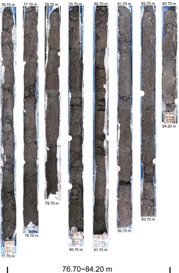
和δ13C,有機物的δ13C、δ15 N、TOC、TON);(5)取得上百個采自 4 個地質剖面的 火山灰、火山岩以及沉積物樣品;(6)鑽取一根長 65 米深度達 84 米的岩芯;(7) 在顯微鏡下觀察沉積物的岩石礦物組成,並用 XRD、SEM、TEM 分析。(8)2008 年 10-11 月間,我們在 Taal 湖岸打了 84 米深的鑽井(TLS B2),取得了 65 米厚的岩芯, 獲取了 Taal 湖盆沉積的完整記錄。 通過上述研究,我們不僅掌握了 Taal 火山湖現代水系的地球化學特徵,在沉積物 岩芯中得到了非常精彩的核爆 14 C 曲線,也建立 Taal 湖近幾百年來的沉積物歷史記 錄。更為重要的是,我們發現了 Fe, Mn, K, Cu, Zn, δ87 Sr 等地球化學指標可以用來反 映火山活動的程度,找到 1991-94 和 2004-06 年這兩次近代 Taal 火山活動異常的現 象,為對研究火山噴發的機制、古火山特徵指標、火山噴發與氣候變化的互動、以 及湖體環境變化提供重要的科學理論和應用基礎。從 2009 年 8 月開始,我們的工作 重點是從 TLS B2 鑽井資料瞭解 Taal 湖的沉積歷史,找出氣候變化和火山噴發事件, 建立氣候變化與區域以及全球氣候系統的關係,判斷在整個全新世期間火山噴發的 頻率和週期。 (A) 84 米長的岩芯 TLS B2 鑽孔整理 我們將岩芯 TLS B2 进行整理、切樣、拍照和岩芯描述。然后,將這 84 米長的岩 芯每 5 公分左右采一個樣品,共取得 1400 個樣品。先從這些樣品中,選出大約 120 個,對每個樣品先用蒸餾水洗滌浮選,用 50 目的分樣篩將樣品中的植物、生物殼體、 粗粒和細粒沉積物分開。部分樣品送給菲律賓火山地震所,岩芯風乾保存。
Fig. 1 Photography of Drill core BH#2 (B)AMS 14
C 定年結果
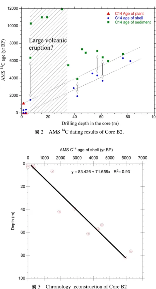
在 2009-2010 的計畫執行期間,我們從 Core B2 從選取了 19 個層位的樣品,從中 篩選中植物殘體(4 個)和貝殼(12 個)樣品,不含上述物質的細粒沉積物 13 個。
將這 29 個樣品送到加州大學爾灣分校的 AMS 14C 實驗室進行定年,結果見表 1。 表 1 部分 Core B2 樣品的 AMS 14 C 定年結果 表 1 中的結果表明(圖 2),貝殼的定年結果與植物殘體接近,沒有顯著的 “reservoir age”,這與我們對重力岩芯樣品定年的結果相符合。由於在整個岩芯中 很難找到木炭進行碳十四定年,而在不同層位中發現有貝殼,因此,用貝殼做為岩 芯的定年物質甚為合適。另外,同一個層位的樣品總有機碳的14 C 年齡通常比貝殼的 年齡偏老(圖 2),這可能是因為:(1)處於淺水湖區,雨水沖刷岸上較老的物質使 得年齡偏老;(2)在沉積物中含有來自岩石的黑炭,在化學處理過程中無法除去, 使得年齡偏老。在沉積物中,碳酸鹽的含量很低,基本符合火山湖的特徵。儘管湖 底伴隨火山活動可能逸出大量 CO2氣體,然而湖水的上下混合作用很強,與大氣 CO2 的交換好,使得水中的溶解 CO2的14C 可以與大氣的14C 達到平衡。所以,生活在水 中的貝殼能夠給出合理的14 C 年齡。因此,我們將所有貝殼的年齡用來建立 Core B2 的時間序列(圖 3)。 從圖 3 的結果來看,Core B2 涵蓋了過去 6 千年的沉積。過去唯一的、史前記錄 的火山噴發被認為是在14 C 年齡 5,380 年前,這一年齡顯然需要修正。因為岩芯 Core B2 顯示湖泊沉積在 6 千年到大約 2 千年前時是完整的、有序的。由於鑽孔達到 84 米時就打不下去了,這有可能打到岩盤。果真如此的話,說明 Taal 湖的形成年齡是 在全新世時期。
圖 2 AMS 14
C dating results of Core B2.
圖 3 Chronology reconstruction of Core B2
目前已測量此岩心深度 0~6m 約 90 個樣品的 TOC 和δ13 CTOC,年齡為過去 500 年。 從沉積物的有機碳及碳同位素數據中看出,TOC 和δ13 CTOC呈明顯的正相關, 與岩心 TLS2 中的關係完全不同。這可能說明,有機碳的來源基本上由碳同位素較重 的湖相自生有機碳和陸上輸入的碳同位素較輕的有機碳相混合,當湖泊生產力增加 時,TOC 和δ13 CTOC同時增加。在距今 350 年之前,TOC 和其他元素含量都很低,可 能是在一次強烈的火山噴發之後,湖泊生產力極低。在此之後,湖泊生產力逐漸恢 復、升高,使湖相生物增加,碳同位素偏重。在西元 1700, 1800,1870~1850、1905~1920 年這些時段,有機碳大幅減少、碳同位素偏輕,可能指示火山噴發事件。 圖 4 岩心 TLS B2 過去 500 年沉積物的有機碳同位素與 TOC (D)Taal 湖沉積物岩芯 TLS B2 中稀酸可溶相的元素含量 对选出的 138 个样品,用 ICP-OES 分析了稀酸可溶相的元素含量,由于篇幅所 限,在此仅列出平均结果,并与短的重力岩心分析结果想比较:
圖 5 Taal 湖岩心稀酸可溶相的元素平均含量對比 結合沉積物特徵和地化資料分析,岩心 TLS-B2 大致有三段明顯的沉積變化:(1) 84~35 米(6000~2500 yr BP),稀酸可溶相以 Fe 和 Mg 為主,Ca 含量一般低於 3000 ppm,個別層位含少量螺殼,Mg, Fe, Mn, Cu, Zn 之間有較好的正相關;(2)35~6 米 (2500~500 yr BP),這段沉積可能是短暫、快速的堆積,含有大量火山灰,基本不 含螺殼,主要元素的含量都很低;(3)6~0 米(500 yr BP 至今),稀酸可溶相以 Fe 和 Ca 為主,各主要元素的濃度從 300 年前至今逐漸增加,Ca 與各元素之間有很好 的正相關。這顯示,西元 1749 年的強烈火山噴發事件,導致 Taal 湖與海的連接阻斷, Taal 湖由海水環境逐漸轉為淡水沉積環境。 (E)本年度計畫期間所完成的論文與會議摘要 學術論文:
1. Naijung Wan, Weiling Chung, Hong-Chun Li*, Huilin Lin, Chuanchou Shen, Teh-Lung Ku, Daoxian Yuan, Meiliang Zhang, Yushi Lin, 2010. The Comparison of Speleothem δ18O Records from Eastern China with Solar Insolation, Ice Core and Marine Records: Similarities and Discrepancies on Different Time Scales. Journal of Asia Earth Sciences 40, 1151–1163. doi:10.1016/j.jseaes.2010.06.010 (SCI) (Impact Factor: 1.842; 5-Year Impact Factor: 2.295)
2. 李廷勇,李紅春*,沈川洲, 杨朝秀, 李俊云, 衣成城, 袁道先, 王建力, 谢世友,
2010. 2006~ 2008 年重庆大气降水δD 和δ18
O 特征初步分析。(Study on the δD and δ18
O characteristics of meteoric precipitation during 2006- 2008 in Chongqing,
China)《水科學進展》21 (6), 757-765。(EI)
3. De’er Zhang, Hong-Chun Li, Teh-Lung Ku, Long-Hua Lu, 2010. Reply to the comment of Cheng et al. on "On linking climate to Chinese dynastic change: Spatial and temporal variations of monsoonal rain" of Zhang et al. Chinese Science Bulletin 55 (32): 3738–3740. (SCI IF: 0.898, Ranking: 23/42 in Multidisciplinary Sciences)
4. De’er Zhang, Hong-Chun Li*, Teh-Lung Ku, Long-Hua Lu, 2010. On Linking Climate to Chinese Dynastic Change: Spatial and Temporal Variations
of Monsoonal Rain. Chinese Science Bulletin 55: 77-83, doi: 10.1007/s11434-009-0312-2. (SCI) (SCI IF: 0.898, Ranking: 23/42 in Multidisciplinary Sciences)
5. 張德二,李紅春*,顧德隆,陸龍驊,2010. 從季風降水的時空特徵檢證季 風與中國朝代更替之關聯。
《科學通報》,
55:60-67。會議摘要:
1. Rudaya N., Li H.-C., Andreev A., Kalugin I., Daryin A., Lee Z.-H., 2010. Environmental changes in the northern Russian Altai during late Holocene derived from Lake Teletskoye sediment cores. The 8th European Palaeobotany - Palynology Conference, July 6-10, 2010, Budapest, Hungary.
2. Hong-Chun Li, 2010. An overview on “Study of CO2 capture, conversion, storage and
reuse through the coastal ocean of Taiwan: The biological pump”. Abstract volume of International Conference of “Carbon Cycle, Biological Pumping And CO2
Sequestration In Coastal Oceans”, June 28-July 01, NCKU, Tainan, Taiwan.
3. Ziqi Liu, Kangning Xiong, Hong-Chun Li, Bin Ying, 2010. The δ13C value of new carbonate samples from different caves: implications of the rank of karst desertification. Abstract volume of International Conference of “Carbon Cycle, Biological Pumping And CO2 Sequestration In Coastal Oceans”, June 28-July 01,
NCKU, Tainan, Taiwan.
4. Ai-Ling Huang, Tsung-Han Lee, Yin Chang, Hong-Chun Li*, 2010. Investigation of heavy metal concentrations in the cultured oyster system in Er-Jen Stream, Tainan. Abstract volume of International Conference of “Carbon Cycle, Biological Pumping And CO2 Sequestration In Coastal Oceans”, June 28-July 01, NCKU, Tainan, Taiwan.
5. Chin-Yao Chiu, Tzu-Shing Kuo, Hui-Ling Lin, Tsung-Han Lee, Hong-Chun Li*, 2010. δ13C, δ15N isotopes and C/N ratios in the sediments collected from sediment traps and gravity cores in the southwest coastal ocean of Taiwan. Abstract volume of International Conference of “Carbon Cycle, Biological Pumping And CO2
Sequestration In Coastal Oceans”, June 28-July 01, NCKU, Tainan, Taiwan.
6. Hong-Chun Li, Hsieh-Yi Lia, Chih-Chung Li, Choung-Joung Chen, 2010. Some Insights from stable isotopes and elemental concentrations in rainwater of Southwestern Taiwan: Effects of rainfall amount, typhoon and storm track. 2010 AGU Western Pacific Geophysics Meeting, June 22-25, Taipei, Taiwan.
7. Megan Chen, Hong-Chun Li*, 2010. C and N isotopes, C/N ratios, minerals and geochemical features of surface sediments from Shihmen Reservoir in northern Taiwan for identifying fine particle sources. 2010 AGU Western Pacific Geophysics Meeting, June 22-25, Taipei, Taiwan.
8. Hua-Chun Yu, Ai-Ling Huang, Hong-Chun Li*, 2010. C and N isotopes of oysters form western Taiwan: preliminary study of biological pump for CO2 sequestration.
2010 AGU Western Pacific Geophysics Meeting, June 22-25, Taipei, Taiwan.
9. Zhong-Han Lee, Zi-Qi Liu, Hong-Chun Li*, 2010. Carbon and oxygen isotopic compositions in water, speleothem, soil and vegetation from Yelang Cave system: a systematic study of climatic and environmental change in central Guizhou, China. 2010 AGU Western Pacific Geophysics Meeting, June 22-25, Taipei, Taiwan.
10. Tz-Shing Kuo, Hong-Chun Li*, 2010. Calibrating nitrogen isotope and content measured by EA/Conflo-IRMS and removing CO interference by liquid nitrogen method. 2010 AGU Western Pacific Geophysics Meeting, June 22-25, Taipei, Taiwan. 11. Nai-Jung Wan, Hong-Chun Li*, 2010. Spatial Evolution of Speleothem δ18
from Eastern China during the last Millennium: Comparison with other Terrestrial and Historical Records. 2010 AGU Western Pacific Geophysics Meeting, June 22-25, Taipei, Taiwan.
12. Natalia Rudaya, Hong-Chun Li*, Tz-Shing Kuo, 2010. Paleoclimatic conditions of Central Asia during the past 12 kyrs reflected by carbon isotopes of pollen grains in the Hoton-Nur Lake sediments from the Mongolian Altai. 2010 AGU Western Pacific Geophysics Meeting, June 22-25, Taipei, Taiwan.
13. Ping-Mei Liew, Hong-Chun Li, 2010. δ13C of TOC in a peat sequence from Toushe Basin of central Taiwan and its paleoclimatic significance. 2010 AGU Western Pacific Geophysics Meeting, June 22-25, Taipei, Taiwan.
14. Peter C. Chu, Hong-Chun Li, 2010. Temporal and spatial variation of δ18O in China since medieval warm period. 2010 AGU Western Pacific Geophysics Meeting, June 22-25, Taipei, Taiwan.
15. Hong-Chun Li, 2010. Some concerns about the influence of East Asian Summer Monsoon on climatic conditions in Asian Continent. Western Pacific Paleoceanography Workshop I: Future Challenge. Jan. 11-14th, 2010, National Taiwan Ocean University, Keelung, Taiwan.
16. Hong-Chun Li,Isabel Israde Alcantara, James L. Bischoff, Da-Ren Wen, Victor Hugo Garduño-Monroy. 2009. Acid-leachable Li and Mg from Lake Cuitzeo sediments in the central Mexico: Paleoclimate change during the past 45 Ka. EOS, AGU Fall Meeting, Dec. 14-18, 2009, San Francisco, USA. (Oral presentation)
17. Tz-Shing Kuo, James L. Bischoff, Isabel Israde Alcantara, Victor Hugo Garduno-Monroy, Hong-Chun Li*. 2009. Organic carbon contents and isotopic compositions in the Lake Cuitzeo sediments from the central Mexico during the past 45 Ka: Changes in lake level and climate. EOS, AGU Fall Meeting, Dec. 14-18, 2009, San Francisco, USA.
18. Zhong-Han Lee, Zi-Qi Liu, Hong-Chun Li*, Chuan-Chou Shen. 2009. Climate and human impacts on vegetation changes in central Guizhou, China: Carbon and oxygen isotopic records in a stalagmite from Yelang Cave. EOS, AGU Fall Meeting, Dec. 14-18, 2009, San Francisco, USA.
19. Hong-Chun Li, Xiaomei Xu, Da-Ren Wen, Nai-Jung Wan, Tz-Shing Kuo, Renato Umali Solidum Jr., Jaime Sincioco, Paul Karson B. Alanis, Nora Campita. 2009. A summary of geochemical study on Taal Lake system: Searching proxies for detecting of Taal volcano eruptions. The 2nd Regional Conference on Geological and Geo-Resources Engineering Research in ASEAN & the Philippines-Taiwan Earth Sciences Conference. August 27 - 28, 2009, Heritage Hotel, Manila, Philippines. (Session chair)
20. Hong-Chun Li, De’er Zhang, Teh-Lung Ku, 2009. On Linking Climate to Chinese Dynastic Change: Spatial and Temporal Variations of Monsoonal Rain. The 6th general meeting of Asia Oceania Geosciences Society, 11 - 15 August, 2009, Suntec International Convention & Exhibition Centre, Singapore. (Invited talk)
六. 計畫成果自評
以下列出計畫書中預期完成之工作項目及成果,並逐項對照給出執行情況: 98-99 年度
(1) Finish pore water samples for geochemistry and isotope analyses. 完成,詳見前面報告內容。
(2) Complete geochemical analyses for the sediment samples of gravity cores TLS1 and TLS2.
完成,詳見前面報告內容。
(3) Describing the 64-m long BH#2 core, making a complete core log and selecting dating materials from the core.
完成,詳見前面報告內容。
(4) Dating the sediments of core TLS1 and BH#2 with AMS 14C method.
完成。在本年度裏,對岩芯 core TLS1 增加了 10 個碳十四年齡,但可能是因 為深部沉積物有些來源淺水區,reworking 的作用導致年齡倒序。對 BH#2 岩芯樣 品的碳十四定年尚在進行中。
(5) Calibrating the dated geochemical variations of core TLS1 with the historic eruption events, finding the geochemical signals of volcanic eruption achieved in the sediments. Modeling geochemical budget of Taal Lake.
完成,詳見前面報告內容。
(6) Conducting partial geochemical analyses for the sediment samples from core BH#2. 完成。
(7) Using tephrachronology of the sediment cores to find out special events, frequency of eruptions.
部分完成。主要因為 tephra layer 並不明顯。在 64 米的岩芯鑽井中,似乎是 幾次很大的噴發事件占主要的沉積厚度,需待定年之後才可以得到資訊。
(8) Supervising one postdoctor scientist for the research work, and one Ph.D. and two M.S. students for their thesis studies. Training Philippine scientists in field and lab works, as well as research approaches.
完成。本計畫聘用溫大任博士,在 2009 年 10-11 月期間,溫大任在菲律賓監督 TAAL 湖岩芯鑽探工作,取回 64 米沉積物岩芯樣品。西南大學劉子琦在 2010.4-9 間,受計畫資助進行博士後研究。在 2009 年 7 月,碩士生李仲弘和郭子興,分 別進行答辯,順利畢業。博士生萬乃容的論文也有所進展,目前已經发表一篇 SCI 論文。
(9) Writing progress report to NSC. Submitting 1-2 manuscripts to SCI journals.
完成,本報告書。同時,2009 年 8 月至 2010 年 10 月底之間,已經有一篇 SCI 論文發表,一篇被接受,正在刊印中。
(10) Providing data results and scientific ideas to the research team of the integrated project. 完成。在 2009 年 8 月 27-29 號於馬尼拉舉行的台-菲地質國際研討會上,本人總 結了過去 3 年來在 Taal 火山湖所做的工作,並將資料和樣品提供給菲律賓火山地 震所,得到了對方的尊重和感謝。在整合計畫中,本子計畫表現優良。 八. 報告附件:出席國際會議研究心得報告及發表論文 2009 年 8 月 1 至 2010 年 10 月 31 日共參加國際會議 3 次和國內會議 4 次,發表論文 摘要 10 篇,其中 4 篇英文,6 篇中文,均為第一作者或通信作者,口頭報告 5 個: 本人於 11 - 15 August 2009 前往新加坡參加第六屆 AOGS(The 6th general meeting of
Asia Oceania Geosciences Society),並被會議邀請給口頭報告,摘要如下:
On Linking Climate to Chinese Dynastic Change: Spatial and Temporal
Variations of Monsoonal Rain
Hong-Chun Li1, De’er Zhang2, Teh-Lung Ku1,3& Long-Hua Lu4
1
Department of Earth Sciences & Research Center of Ocean Environment and Technology, National Cheng-Kung University, Tainan, Taiwan 70101, ROC.
*e-mail: [email protected].
2
National Climate Center, China Meteorological Administration, Beijing 100081, China.
3
Department of Earth Sciences, University of Southern California, Los Angeles, CA 90089, USA.
4
Chinese Academy of Meteorological Sciences, Beijing 100081, China.
East Asian Summer Monsoon (EASM) plays an important role in affecting rainfall in China. Work on high-resolution paleoclimate reconstructions is poised to advancing our understanding of global environmental changes and climate-society interactions. That a stronger (or weaker) EASM brings about more abundant (or deficit) rainfall over the whole eastern China could well be valid on longer-than-centennial scales, but on decadal or shorter intervals it becomes problematic. The challenge appears to lie in recognizing and coping with the spatial and temporal variability, as time scale for the system of interest shrinks. Recent reports of two high-resolution paleoclimate reconstructions (Yancheva et al., Nature
445, 74-77, 2007; Zhang et al., Science 322, 940-942, 2008) proposed a causal correlation
between the EASM intensity and rise/fall of Chinese dynasties and suggested that climate played a key role in affecting Chinese dynastic changes. By detailed examinations, we show many strong evidences which are exactly opposite to the aforementioned correlations, e.g., periods of heavy and light δ18
O values in the Wanxiang Cave record may relate to times of either social stability or turmoil in Chinese history, defying meaningful correlations. Aside from many exceptions to the causal correlation, both instrumental and historical climate records, as well as high-resolution speleothem records show strong spatial variations of rainfall on annual-to-decadal scales over eastern China. Although summer rainfall that annually delivers most of the moisture to China is closely related to the intensity of EASM, the relationship between rainfall and EASM intensity exhibits regional disparity. Our observations suggest: (1) Taking paleo-proxy records from a single locality in eastern China to imply changes in drought/wetness as to affect the cultural and political history of China is fraught with uncertainty. (2) On annual-to-decadal scales, the thesis that δ18
O in speleothems can be used as a proxy for the EAM strength lacks empirical underpinnings.
我於 August 27 - 28, 2009 參加在菲律賓馬尼拉舉辦的 The 2nd Regional Conference on Geological and Geo-Resources Engineering Research in ASEAN & the Philippines-Taiwan Earth Sciences Conference. 在會議上擔任分會主持人,並給了口頭 報告,以下是報告摘要:
A summary of geochemical study on Taal Lake system: Searching proxies for detecting of Taal volcano eruptions
Hong-Chun Li1, Xiaomei Xu2, Da-Ren Wen1, Nai-Jung Wan1, Tz-Shing Kuo1, Renato Umali Solidum Jr.3, Jaime Sincioco3, Paul Karson B. Alanis3, Nora Campita3
1
Department of Earth Sciences, National Cheng-Kung University, Tainan, Taiwan 70101, ROC ([email protected] / 00(886)-6-2757575 ext. 65433).
2
Department of Earth System Science, University of California, Irvine, CA 92697, USA ([email protected] ).
3
Philippine Institute of Volcanology and Seismology, Quezon, 1101 Philippines
Taal Lake is located in Batangas Province of central Philippines (14°0.01'N, 120°59.1'E), with a surface area of 267 km2, a maximum depth of 176 m and an elevation of 3 m above sea level. The lake occupies the famous Taal Volcano system which consists of a 15×22-km prehistoric caldera. The 5-km-wide Taal Volcano Island which has 47 craters and 4 maars, lies in the north-central Taal Lake. With 34 recorded eruptions, Taal Volcano is one of the 16 monitored volcanoes by the Global Volcanism Network.
During the past 3 years, we have conducted several trips to Taal and measured water temperatures at different stations and depths; collected water samples from Taal Lake, Main Crater Lake, springs, streams, wells and rains in the area; taken three gravity cores from water depths of 15m and ~100m and one 64-m long drill core from the western shore of Taal Lake; and sampled a few outcrops of volcanic and lake deposits in the area. The measured water temperatures ranging from 26.5 to 29oC show that the thermal gradient of Taal was very weak during the late Novembers in 2006 and 2007, perhaps due to thermal input from the Taal Volcano Island and bottom of Taal Lake. The deepest part of Main Crater Lake is 61m with a constant water temperature of 31oC throughout the depth.
We have analyzed geochemical properties including concentrations of Na, K, Mg, Ca, Al, Fe, Mn, Sr, Ba, Co, Ni, Cu, Zn, Pb, As, Ti, Cr, and Cd, and isotopic values of δD, δ18
O and δ87
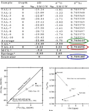
Sr in the water samples. From these results, we conclude: (1) High concentrations of Na, K, Mg, Ca, Al, Fe, Mn in geothermal fluid at Taal are from input of volcanic water, dissolution of volcanic rocks, and incursion of seawater. However, the major ions are introduced by both seawater and geothermal inputs, so that they could not be used as index of volcanic activity. (2) Among trace and heavy metal elements, Fe, Mn, Cu and Zn may be used as indicators of volcanic activity. (3) Isotopic composition of Taal Lake bias from MWL indicates mixing of isotopically heavy geothermal fluid and isotopically light surface input. Therefore, heavier δ18
O values of the lake recorded in the lake sediments may reflect increased geothermal fluid caused by volcanic activity. (4) δ87
Sr of Taal Lake reveals mixing of three end-members including surface runoff, geothermal fluid and seawater. The δ87Sr value of the geothermal fluid is about 1000ppm lower than that of the lake waters. Therefore, δ87
Our most significant study is on a 120-cm long gravity core, Core TLS2, retrieved from 15-m water depth of Taal Lake. Sixteen AMS 14C dates were made on plant remains at different layers of the core, matching very well with the bomb 14C curve determined in tree rings. The distribution of the bomb 14C profile allows us to establish the chronology of the core which yields a constant sedimentation rate of 2.04cm/year spanning the past 60 years. Based on this chronology, living plants around Taal Lake may have a lower initial Δ14
C (-30‰) compared to the Modern Standard.
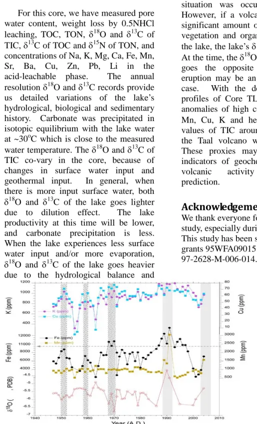
For this core, we have measured pore water content, weight loss by 0.5NHCl leaching, TOC, TON, δ18O and δ13C of TIC, δ13C of TOC and δ15
N of TON, and concentrations of Na, K, Mg, Ca, Fe, Mn, Sr, Ba, Cu, Zn, Pb, Li in the acid-leachable phase. The annual resolution δ18O and δ13
C records provide us detailed variations of the lake’s hydrological, biological and sedimentary history. Carbonate was precipitated in isotopic equilibrium with the lake water at ~30oC which is close to the measured water temperature. The δ18
O and δ13C of TIC co-vary in the core, because of changes in surface water input and geothermal input. In general, when there is more input surface water, both δ18O and δ13
C of the lake goes lighter due to dilution effect. The lake productivity at this time will be lower, and carbonate precipitation is less. When the lake experiences less surface water input and/or more evaporation, δ18O and δ13
C of the lake goes heavier due to the hydrological balance and increased lake productivity. However, when the volcanic activity increases, significant amount of hydrothermal input and deep CO2 input will lead to
increase of lake’s δ18O and δ13
C. Both carbonate and organic carbon will decrease due to the influence of volcanic input. This situation was occurred around 1991. However, if a volcanic eruption causes significant amount of dead carbon from vegetation and organism in and around the lake, the lake’s δ13C will be depleted. At the time, the δ18O and δ13
C of the lake goes the opposite way. The 1965 eruption may be an example of such a case. With the detailed geochemical profiles of Core TLS2, we have found anomalies of high concentrations of Fe, Mn, Cu, K and heavy δ18O and δ13
C values of TIC around 1991-1994 when the Taal volcano was active. These proxies may be considered as indicators of geochemically monitoring volcanic activity for long-term prediction.
本人參加 2009 年 AGU 年會,並在會上做了口頭演講,摘要如下: Acid-leachable Li and Mg from Lake Cuitzeo sediments in the central Mexico: Paleoclimate change during the past 45 Ka
Hong-Chun Li1,Isabel Israde Alcantara2, James L. Bischoff3, Da-Ren Wen1, Victor Hugo Garduño-Monroy2
1 Department of Earth Sciences, National Cheng-Kung University, Tainan, Taiwan 70101, ROC (00886-6-2757575 ext 65433, [email protected] )
2 Department of Geology and Mineralogy, Instituto de Investigaciones Metalurgicas, Edif. U Ciudad Universitaria, Morelia, Michoacan 58090, Mexico (0052-443-3223500 ext 4024, [email protected]), [email protected]
3 US Geological Survey, ms/470, Menlo Park, CA 94025, USA (650-329-4187,
Located in Michoacán state of south-central Mexico (19°56’N, 101°5’W), Lake Cuitzeo is an alkaline lake with an area of ~400 km2, average depth of 27m and elevation of 1821m. A 27-m long core was retrieved from the lake, covering about 127-kyr depositional history.
The chronology of the upper 9.2m of the core has been reconstructed by radiocarbon dates, showing a continuous deposition during the past 45 Ka. Using 0.5N HCl for leaching the de-ionized water washed lake sediments, we have measured the acid-leachable (AL) elements including Na, K, Li, Mg and Si by ICP-OES. Comparing to the total Si content in bulk sediments ranging from 10 to 40 wt.% with an average of 25.2 ± 4.3 wt.%, the AL Si ranges from 0.064 to 0.375 wt.% with an average of 0.253 ± 0.048 wt.%. The AL Mg content has strongly linear correlation with the total Mg content in the bulk sediments, but accounts for ~55% of the total Mg content. When the carbonate content in the sediment is greater than 10%, the weight loss by the acid-leaching is mainly from dissolution of carbonate. In addition, when the AL Mg is less than 1%, AL Li and AL Mg appear strongly linear correlation. Thus, the AL Li and Mg contents are mainly from authigenic minerals formed in the lake, such as carbonate and sepiolite. When Mg was used up in the lake due to precipitation of carbonate and sepiolite, Li will substitute in sepiolite under the hyper saline and alkaline lake. Therefore, AL Li and Mg contents in the lake sediments can be used as indicators of lake hydrological change under different climatic conditions. High CaCO3%, Li and Mg contents in the periods of 2~12Ka, 19~24Ka,
28~31Ka, 33~34Ka, 35~38Ka and 43~45Ka, indicate higher salinity and alkalinity of the lake hence lower lake levels might be caused by dry and/or warm climates. During 12~20Ka, the lake was relatively fresh and deeper, reflecting cold but wet climatic conditions due to jet stream shifted south during LGM.
Taal 湖研究計畫三年來的總結報告:
A summary of geochemical
study on Taal Lake system:
Searching proxies for detecting
of Taal volcano eruptions
Li, H.-C.1, Xu, M.-X.2, Wen, D.-R.1, Wan, N.-J.1,
Kuo, T.-S.1, Solidum Jr., R. U.3, Sincioco, J.3,
Alanis, P. K.3 and Campita, N.3
1 Department of Earth Sciences, National Cheng-Kung
University, Tainan, Taiwan 70101, ROC
2 Department of Earth System Science, University of
California, Irvine, CA 92697, USA
3 Philippine Institute of Volcanology and Seismology,
Quezon, 1101 Philippines
Abstract
During the past 3 years, we have conducted several trips to Taal and measured water
temperatures at different stations and depths; collected water samples from Taal Lake, Main Crater Lake, springs, streams, wells and rains in the area; taken three gravity cores from water depths of 15m and ~100m and one 64-m long drill core from the western shore of Taal Lake; and sampled a few outcrops of volcanic and lake deposits in the area. The measured water temperatures ranging from 26.5 to 29oC show
that the thermal gradient of Taal was very weak during the late Novembers in 2006 and 2007, perhaps due to thermal input from the Taal Volcano Island and bottom of Taal Lake. The deepest part of Main Crater Lake is 61m with a constant water temperature of 31oC throughout
the depth.
We have analyzed geochemical properties including concentrations of Na, K, Mg, Ca, Al, Fe, Mn, Sr, Ba, Co, Ni, Cu, Zn, Pb, As, Ti, Cr, and Cd, and isotopic values of δD, δ18O and
we conclude: (1) High concentrations of Na, K, Mg, Ca, Al, Fe, Mn in geothermal fluid at Taal are from input of volcanic water, dissolution of volcanic rocks, and incursion of seawater. However, the major ions are introduced by both seawater and geothermal inputs, so that they could not be used as index of volcanic activity. (2) Among trace and heavy metal elements, Fe, Mn, Cu and Zn may be used as indicators of volcanic activity. (3) Isotopic composition of Taal Lake bias from MWL indicates mixing of isotopically heavy geothermal fluid and isotopically light surface input. Therefore, heavier δ18O values of the
lake recorded in the lake sediments may reflect increased geothermal fluid caused by volcanic activity. (4) δ87Sr of Taal Lake
reveals mixing of three end-members including surface runoff, geothermal fluid and seawater. The δ87Sr value of the geothermal
fluid is about 1000ppm lower than that of the lake waters. Therefore, δ87Sr may be a good
indicator of volcanic activity.
A 120-cm long gravity core, Core TLS2, retrieved from 15-m water depth of Taal Lake, was dated by AMS 14C on plant remains at different layers of the core, matching very well with the bomb
14
C curve determined in tree rings. The distribution of the bomb 14C profile allows us to establish the chronology of the core which yields a constant sedimentation rate of 2.04cm/year spanning the past 60 years.
For this core, we have measured pore water content, weight loss by 0.5NHCl leaching, TOC, TON, δ18O and δ13
C of TIC, δ13C of TOC and δ15
N of TON, and concentrations of Na, K, Mg, Ca, Fe, Mn, Sr, Ba, Cu, Zn, Pb, Li in the acid-leachable phase. The annual resolution δ18O and δ13
C records provide us detailed variations of the lake’s hydrological, biological and sedimentary history. Carbonate was precipitated in isotopic equilibrium with the lake water at ~30oC which is close to the measured water temperature. The δ18O and δ13
C of TIC co-vary in the core, because of changes in surface water input and geothermal input. In general, when there is more input surface water, both δ18
O
and δ13C of the lake goes lighter due to dilution effect. The lake productivity at this time will be lower, and carbonate precipitation is less. When the lake experiences less surface water input and/or more evaporation, δ18O and δ13
C of the lake goes heavier due to the hydrological balance and increased lake productivity. However, when the volcanic activity increases, significant amount of hydrothermal input and deep CO2 input will lead to increase of lake’s
δ18O and δ13
C. Both carbonate and organic carbon will decrease due to the influence of volcanic input. This situation was occurred around 1991. However, if a volcanic eruption causes significant amount of dead carbon from vegetation and organism in and around the lake, the lake’s δ13
C will be depleted. At the time, the δ18O and δ13
C of the lake goes the opposite way. The 1965 eruption may be an example of such a case. With the detailed geochemical profiles of Core TLS2, we have found anomalies of high concentrations of Fe, Mn, Cu, K and heavy δ18O and δ13
C values of TIC around 1991-1994 when the Taal volcano was active. These proxies may be considered as indicators of geochemically monitoring volcanic activity for long-term prediction.
Keywords
Geochemistry, Stable isotopes, Radiocarbon dating, Taal Volcano, Volcanic activity, Paleo-environment
Introduction
Located in Batangas Province of central Philippines and ~55 km south of Manila, Taal Volcano (14°00.1'N, 120° 59.1'E) is situated on the southwestern part of Luzon Island in the Philippines Archipelago. The volcano consists of a 15×22-km prehistoric caldera which is occupied by Lake Taal (LT), and the active vent complex of Volcano Island
that contains a lake, named the Main Crater Lake (MCL) (Newhall and Dzurisin, 1988). With 33 recorded eruptions, Taal Volcano is considered one of the most active volcanic centers in the Philippines and is one of the 16 monitored volcanoes by the Global Volcanism Network (Witham, 2005). Historic documents show that the volcanic eruption of Taal has been very active. Powerful events occurred in 1754, 1911, and 1965, taking people’s lives and changing the environments. The eruptions produced base surges, pyroclastic flows, and lake seiches that caused extensive damage of shore towns and villages around Lake Taal, reaching areas as far as Manila (Moore et al., 1966; Kokelaar, 1986; Simkin and Siebert, 1994). Taal Volcano has claimed more than 1500 human lives since the beginning of the eighteenth century (Simkin and Siebert, 1994). Now, several million people live within a 20-km radius of Taal’s caldera rim, making the volcano the largest threat to the Philippine population. Because of its high level activity and proximity to densely populated location, the Philippine Institute of Volcanology and Seismology (PHIVOLCS) has nominated Taal as a Decade Volcano (Torres et al., 1995). Recently, an alarming increase of Taal eruption has been determined by PHIVOLCS due to elevated seismicity, deformation, newly developed mud geysers and increased bubbling and temperature of the MCL, as well as formation of new fissures on Volcano Island. The current situation also took place between 1991 and 1994 when a new magma was introduced beneath the Main Crater (Torres et al. 1995). Although these signs of growing instability may not culminate in an eruption of Taal, but the increased alarming level will prompt voluntary evacuation of the islanders and has already strongly impact of economy and society of the region.
While the above descriptions give the importance of study on Taal Volcano, our understanding of eruptive history, its cycle and controlling factors are very limited due to the short historic records. Although the 33 historic eruptions provide us some information about behaviors of the volcano over the past 500 years, there are some shortages about the historic documents. First, what was the strongest volcanic eruption (or the highest Volcanic Explosivity Index (VEI)) of Taal Volcano? How many severe volcanic eruptions in the past? What are the cycles of those severe eruptions? Only VEI ≥3 types of eruptio ns are considered as severe, violent and terrific eruptions which significantly affect human being. Therefore, we are more care about these strong eruptions. Out of 33 historic events of Taal eruption, there were only 12 eruptions probably with VEI ≥3, but no one was greater than VEI of 4. Although the nearly 500-year historic record is relatively long compared with many other volcanoes in the world, it is still a very short record in the Holocene time period. If there was a strong eruption with VEI greater than 4 before 1570 AD, it might be recorded historically. The stronger eruptions we studied, the better understanding of their forcing factors should be. For a time interval longer than a few thousand years, we may detect a detailed eruptive history of Taal and establish cycles of strong eruptions. Therefore, this proposal attempts to reconstruct volcanic eruptions of Taal during the Holocene. Second, the information of eruptions before 1885 AD is very brief with many question marks. These historic records provide only limited data base for studying controlling factors and impacts of the volcano. By studying geological archives, we may obtain better pictures about these ancient and historic eruptions.
Third, previous studies on
paleo-activities of volcanic eruptions have used mostly dating techniques (e.g.,
radiocarbon, 230Th/U, 40Ar-39Ar, TL, fission track, etc.) on volcanic materials such as ash/tephra layers, lava flows and volcanic rocks, as well as related time sequences such as tree ring records, tree stumps, organic carbons in overlying or underlain sediments. This approach is used for eruptive event that need chronological information, not for detecting eruption events. In some cases, researchers found volcanic ash/tephra layers in sediment cores and dated them with various techniques. However, some volcanic eruptions may not produce ash or tephra materials. Therefore, we need to find a way for detecting volcanic inputs. This study attempts to use geochemical proxies such as elemental concentrations, isotopes and their ratios in lake and/or marine sediments to seek answers for the following questions: (1) what are the sensitive proxies of volcanic eruptions that can be archived in the sediments? (2) Can we reconstruct of volcanic eruption history of Taal Volcano from the paleo-proxy of sediment cores from Lake Taal and Balayan Bay during the Holocene time? (3) What are the frequency and cycle of Taal Volcano eruption? And, what are the controlling factors of these eruptions? (4) What are the Holocene paleoclimatic and paleo-environmental conditions in the central Philippine area? (5) How is the water quality of Lake Taal at the present and near future under the influence of volcanic input, climate and human impact?
Major results
During the trips of Nov. 2006 and 2007, we took water samples from TL and MCL and measured water temperature and depth with an Automatic Temperature and Depth Recorder. The temperature profiles exhibit small temperature gradients with water depths >50m. This observation reveals quite
different thermal gradient feature from normal lakes in non-volcanic related lakes. Our observations are similar to the previous surveys of Delmelle et al. (1998). This is because the thermal input and degassing from the lake bottom causing the fast mixing of the water column. Such a thermal gradient influences the geochemical system of Lake Taal. And, these profiles will be benefit to the dynamic model of heat, geochemical and isotopic budgets.
We have measured the concentrations of Na, K, Mg, Ca, Al, Fe, Mn, Sr, Ba, Co, Ni, Cu, Zn, Pb, As, Ti, Cr, and Cd, and isotopic values of δD, δ18O and δ87Sr in the water samples. Our results agree very well with the results of Delmelle et al. (1998) and of Castillo and Gonzales (1976). Tables
1-3 list the data results.
From these results, we have obtained following conclusions:
(1) Filtered and non-filtered samples have similar concentrations, implying that particle phase in the water samples is insignificant. There is no chemical gradient in the water column shown by the similar concentrations between TAL-4 (from 40m deep) and TAL-5 (surface at the same site), which corresponds to the weak thermal gradient shown in Fig. 4a. The water column is mixed very well.
(2) The geothermal fluid (TAL-11) contains much higher concentrations of measured major and minor elements (Na, K, Mg, Ca, Al, Fe, Mn), reflecting input of volcanic water, dissolution of volcanic rocks, and incursion of seawater. TAL-7 represents a mixture of geothermal vent with Lake Taal water. Although this sample was taken from near shore (~10m away from the island and 2m water depth), we can still see the influence of the geothermal input. However, the geothermal water is quickly diluted in the lake.
(3) Isotopic composition of Taal Lake bias from MWL indicates strong evaporation, and mixing with groundwater and seawater (Fig. 1a).
(4) Sr isotopic composition of Taal Lake reveals mixing of at least three end-members including surface runoff, hydrothermal fluid and seawater. The δ87
Sr value of the volcanic water (TAL-11) is about 1000ppm lower than that of the lake waters. Therefore, δ87
Sr may be a good indicator of volcanic activity (Fig. 1b).
(5) High concentrations of major ions in Taal Lake are introduced by both seawater and hydrothermal inputs, so that they could not be used as index of volcanic activity.
(6) Among trace and heavy metal elements, Fe, Mn, Cu and Zn may be used as indicators of volcanic activity.
Our most significant study is on a 120-cm long gravity core, Core TLS2, retrieved from 15-m water depth of Taal Lake. Sixteen AMS 14C dates were made on plant remains at different layers of the core, matching very well with the bomb 14C curve determined in tree rings (Fig. 2). The distribution of the bomb
14
C profile allows us to establish the chronology of the core which yields a constant sedimentation rate of 2.04cm/year spanning the past 60 years.
Table 1 Major and minor elemental
contents (ppm) in water samples from Lake Taal. * Data from Delmelle et al., 1998.
Table 2 Trace/heavy metal
concentrations (ppm) in water samples of Lake Taal.
Table 3 Stable isotopic compositions in
water samples of Lake Taal. * Data from Delmelle et al., 1998.
Figure 1. (a) δD and δ18O values; and (b) δ87
Sr values of water samples from Taal Lake basin.
Figure 2: Comparison between the ∆14C of samples from Core TLS2 (lower panel) and the bomb 14C curve of the atmospheric CO2 (upper panel). The cross symbols
with calendar years stand for possible match with the bomb 14C curve of the atmospheric CO2.
For this core, we have measured pore water content, weight loss by 0.5NHCl leaching, TOC, TON, δ18O and δ13
C of TIC, δ13C of TOC and δ15
N of TON, and concentrations of Na, K, Mg, Ca, Fe, Mn, Sr, Ba, Cu, Zn, Pb, Li in the acid-leachable phase. The annual resolution δ18O and δ13
C records provide us detailed variations of the lake’s hydrological, biological and sedimentary history. Carbonate was precipitated in isotopic equilibrium with the lake water at ~30oC which is close to the measured water temperature. The δ18O and δ13
C of TIC co-vary in the core, because of changes in surface water input and geothermal input. In general, when there is more input surface water, both δ18O and δ13
C of the lake goes lighter due to dilution effect. The lake productivity at this time will be lower, and carbonate precipitation is less. When the lake experiences less surface water input and/or more evaporation, δ18O and δ13
C of the lake goes heavier due to the hydrological balance and
increased lake productivity. However, when the volcanic activity increases, significant amount of hydrothermal input and deep CO2 input will lead to increase
of lake’s δ18O and δ13
C. Both carbonate and organic carbon will decrease due to the influence of volcanic input. This situation was occurred around 1991. However, if a volcanic eruption causes significant amount of dead carbon from vegetation and organism in and around the lake, the lake’s δ13
C will be depleted. At the time, the δ18O and δ13
C of the lake goes the opposite way. The 1965 eruption may be an example of such a case. With the detailed geochemical profiles of Core TLS2, we have found anomalies of high concentrations of Fe, Mn, Cu, K and heavy δ18O and δ13
C values of TIC around 1991-1994 when the Taal volcano was active (Fig. 3). These proxies may be considered as indicators of geochemically monitoring volcanic activity for long-term prediction.
Acknowledgements
We thank everyone for their help in this study, especially during the field trips. This study has been supported by NSC grants 95WFA0901514 and
24
Figure 3. Geochemical proxies in Core TLS2 indicate geothermal activities of Taal Volcano
during the past 60 years. Increased concentrations of K, Cu, Fe and Mn and δ18
O values reflect hydrothermal inputs to the lake.
References
[1] Castillo, B.B., and Gonzales, L.L. Hydrology of Taal Lake. Fish. Res. J. Philipp., 1 (2), (1976), 62-75. [2] Delmelle, P., Kusakabe, M., Bernard, A., Fischer, T., de Brouwer, S., and del Mundo, E. Geochemical and isotopic evidence for seawater contamination of the hydrothermal system of Taal Volcano, Luzon, the Philippines. Bull Volcanol. 59, (1998), 562–576.
[3] Kokelaar, P. Magma–water interactions in subaqueous and emergent basaltic volcanism. Bul.l
Volcanol. 48, (1986), 275–289.
[4] Moore, J.G., Nakamura, K., and Alcaraz,
A.P. The 1965 eruption of Taal Volcano. Science 151, (1966), 955–960.
[5] Newhall, C.G., and Dzurisin, D. Historical unrest large calderas of the world. US Geol Surv Bull
1855, (1988), 1–599.
[6] Simkin, T., and Siebert, L. Volcanoes of the world. Geoscience Press, Tucson, pp 1–349, (1994). [7] Torres, R.C., Self, S., Punongbayan, R.S. Attention focuses on Taal: Decade Volcano of the Philippines. EOS 76 (24), (1995), 241, 246–247
[8] Witham, C.S. Volcanic disasters and indicents: a new database. J Volc Geotherm Res 148, (2005), 191-233.
25
1
國科會補助專題研究計畫項下出席國際學術會議心得報告
日期:2009 年 9 月 10 日一、參加會議經過
8/26 台南—高雄—馬尼拉。清晨 5:10 搭乘接駁車前往高雄小港機場,然後搭乘中
華航空公司 9 點的飛機飛往馬尼拉;10:45 到達。菲方派專人在飛機出口迎接,帶我直
接從 VIP 出口出關。然後由專車送往 Heritage Hotel。住下後,在酒店準備能源國家型計
計畫編號
NSC 98-2116-M-002-026
計畫名稱
台灣與菲律賓的地體動力學研究--Taal 湖以及周邊地區地球化學系
統研究:重建菲律賓中部全新世以來古氣候和火山噴發歷史(III)
出國人員
姓名
李紅春
服務機構
及職稱
國立成功大學地球科學系/國立
臺灣大學地質科學系 教授
會議時間
2009 年 8 月
11 日至 2009 年
8 月 15 日
會議地點
Heritage Hotel, Manila, Philippines
會議名稱
(中文)第 2 屆
菲律賓-臺灣地球科學會議
(英文)
2
ndRegional Conference on Geological and
Geo-Resources Engineering Research in ASEAN & Philippines
-Taiwan Earth Sciences Conference
發表論文
題目
(中文)塔奧湖系統的地球化學研究總結:探索塔奧火山噴發的代用指
標
(英文)
A summary of geochemical study on Taal Lake system: Searching proxies for detecting of Taal volcano eruptions2
畫的目標導向性整合計畫的申請。晚上 7 點,參加歡迎酒會,與臺灣來的學者一起和菲
方人員交流。
8/27~8/28 馬尼拉,第 2 屆菲律賓-臺灣地球科學會議(Philippines -Taiwan Earth
Sciences Conference)
。27 日,開幕式,照相,接下來一整天會議,參加 Session 1B:
Geochemical and geophysical studies of convergent margins. Session 2B: Marginal Basin
evolution and the East-SE Asian tectonics. Session 3B: Geophysics and space geodesy and
their applications in crustal deformation studies. 對整個菲律賓海、南中國海以及臺灣海域
的大背景有所瞭解。28 日,參加 Session 4B: Monitoring for and reducing geological hazards
risks. 主持 Session 5B(10:50-12:10) : Monitoring for and reducing geological hazards risks.
在這個 Session 中三個是關於 Taal 湖研究工作的,其中包括本人的報告,另一個是關
於 Bataan 核電廠地區的斷層活動研究。下午的會議由於我要趕 5 點的飛機,只參加了
一個小時。
8/28 馬尼拉—桃園國際機場—台南。29 號沒有飛高雄的班機,為參加 29 號在臺
北舉行的能源國家型整合計畫申請說明,所以 28 號返回臺灣。
二、與會心得
1. 參加在馬尼拉舉行的第 2 屆菲律賓-臺灣地球科學會議(Philippines -Taiwan Earth
Sciences Conference)
。
2. 宣讀題為“A summary of geochemical study on Taal Lake system: Searching proxies
for detecting of Taal volcano eruptions”的論文。本人的研究包括三年來對 Taal 火山湖整
個系統地研究,有大量詳實地資料結果和科學價值,受到與會者的熱情關注,有三位與
會者提了問題,其中菲律賓火山與地震研究所的所長以他們觀察的 1990 年 Taal 火山活
3
動的記錄來證實我的地球化學異常,這是非常有價值的研究結果。(見附件摘要)。
3.共同主持分會“Session 4B: Monitoring for and reducing geologic hazards risks”。在
我主持的分會中,菲律賓大學國家地質科學研究所所長 Arcilia 教授關於 Bataan 核電
廠地區的斷層活動研究的發言引起了激烈的爭論,一方面他的研究認為沒有證據表明在
核電廠之下或者周圍發現斷層,國家不應該把耗資 22 億美元的核電廠停產,而且要每
年花 100 萬美元去維持電機轉動。另一方面的觀點,認為在這個位置上,連接地質構造
的相鄰區域,發現斷層活動,按照活動斷層的定義,這個區域範圍不能有核電廠。所以,
兩派產生激烈地爭論,顯然涉及到菲律賓的政治與社會問題。我按照主辦單位的要求平
息了這場爭論。
4. 參與菲律賓學者進行學術交流。尤其是與菲律賓國家氣象局的 Nathaniel Servando
博士取得聯繫,請他提供菲律賓的氣象資料給我,對 Taal 地區的研究結果進行氣候
影響的解釋。
執行國科會三年期的計畫:台灣與菲 律賓的地體動力學研究
--Taal 湖以及周邊地區地
球化學系統研究:重建菲 律賓中部全新世以來古氣候和火山噴發歷史。三年來累積
了相當豐富的資料,取得許多成果。這次在會上彙報,贏得了好評。在研究結果解
釋上,本人的地球化學資料需要與菲方的實地觀測現象相結合。在討論中,雙方的
結論相互驗證,在文章發表上有非常重要的作用。本人的研究結果,預測菲律賓 Taal
火山在近幾年的活動增強,需要嚴密監視。
三、考察參觀活動(無是項活動者略)
四、建議
開展合作,加強交流。
4
五、攜回資料名稱及內容
會議論文集
1
國科會補助專題研究計畫項下出席國際學術會議心得報告
日期:2010 年 1 月 20 日一、參加會議經過
2009.12.12 從臺北飛洛杉磯,先訪問我的母校南加州大學,然後開車去三藩市,
參加 AGU 年會,在會議上除了順利地完成自己的口頭報告之外,也參與了許多研究
成果的討論,學習新的方法和技術,結識同行專家,開展合作研究。另外,參加了
臺灣之夜的聚會,與臺灣學者以及旅美華人學者共聚一堂。12 月 20 日,從洛杉磯返
回臺灣。
計畫編號
NSC 98-2116-M-002-026
計畫名稱
台灣與菲律賓的地體動力學研究--Taal 湖以及周邊地區地球化學系
統研究:重建菲律賓中部全新世以來古氣候和火山噴發歷史(III)
出國人員
姓名
李紅春
服務機構
及職稱
國立成功大學地球科學系/國立
臺灣大學地質科學系 教授
會議時間
2009 年 12 月
14 日至 2009 年
12 月 18 日
會議地點
San Francisco, CA,USA
會議名稱
(中文)2010 美國地球物理學會秋季年會
(英文)
2010 AGU Fall meeting
發表論文
題目
(中文) 墨西哥中部
Cuitzeo 湖沉積物中稀酸可溶相 Li 和 Mg 反映過去 45 千 年的古氣候變化(英文)
Acid-leachable Li and Mg from Lake Cuitzeo sediments in the central Mexico: Paleoclimate change during the past 45 Ka2
二、與會心得
職在 2009 年邀請美國地調所資深地球化學專家 James Bischoff 來台之後,他介紹
我進行墨西哥中部一個湖泊的研究,之後與墨西哥的 MICHOACAN 大學簽署了 MOU。在
一年多的時間裏,我們完成了對這個湖泊岩芯的地球化學分析工作,一方面重建了
這個地區過去 4.5 萬年來的古氣候記錄和古環境變化,另一方面找到了關於 1.2 萬
年前新仙女木事件之前的外星隕石撞擊地球的證據。這一發現非常重要,不僅可以
解釋北美 Rancholabrean 文化的滅絕,也可以解釋 Younger Dryas 冷事件的起因。
這項研究工作對北美季風與全球氣候系統的變化有了深入的瞭解,這也是為什麼在
這次國際會議上為安排為口頭演講的原因之一。
每年的美國地球物理年會(AGU)秋季會議是全世界最大的地球科學學術會議,參加
人數超過 1 萬 5 千人,來自世界各地的學者在不同的地學領域裡交流。在這樣大規
模的國際會議上進行學術交流,可以使得學術成果得到更多的認知和回饋。在為期 5
天的會議中,我與自來世界各地的學者進行學術交流,掌握研究古氣候尤其是有關
季風變化以及控制因素的研究進展,除了在會議上做了口頭演講之外,認識了一些
新的學者,為今後的合作架好橋樑。在幾天的會議中,也與多年合作的學者們,如
來自美國、以色列、德國的科學家深入交流,讓他們瞭解臺灣的學術研究進展以及
我在成功大學的成就。我的演講讓來自各國的學者瞭解臺灣的研究水準,報告內容
獲得肯定和好評。
三、考察參觀活動(無是項活動者略)
四、建議
開展合作,加強交流。
3
五、攜回資料名稱及內容
會議論文集
六、其他: 會議摘要
Acid-leachable Li and Mg from Lake Cuitzeo sediments in the central Mexico: Paleoclimate change during the past 45 Ka
Hong-Chun Li1,Isabel Israde Alcantara2, James L. Bischoff3, Da-Ren Wen1, Victor Hugo Garduño-Monroy2
1 Department of Earth Sciences, National Cheng-Kung University, Tainan, Taiwan 70101, ROC (00886-6-2757575 ext 65433, [email protected] )
2 Department of Geology and Mineralogy, Instituto de Investigaciones Metalurgicas, Edif. U Ciudad Universitaria, Morelia, Michoacan 58090, Mexico (0052-443-3223500 ext 4024, [email protected]), [email protected]
3 US Geological Survey, ms/470, Menlo Park, CA 94025, USA (650-329-4187, [email protected])
Located in Michoacán state of south-central Mexico (19°56’N, 101°5’W), Lake Cuitzeo is an alkaline lake with an area of ~400 km2, average depth of 27m and elevation of 1821m. A 27-m long core was retrieved from the lake, covering about 127-kyr depositional history. The chronology of the upper 9.2m of the core has been reconstructed by radiocarbon dates, showing a continuous deposition during the past 45 Ka. Using 0.5N HCl for leaching the de-ionized water washed lake sediments, we have measured the acid-leachable (AL) elements including Na, K, Li, Mg and Si by ICP-OES. Comparing to the total Si content in bulk sediments ranging from 10 to 40 wt.% with an average of 25.2 ± 4.3 wt.%, the AL Si ranges from 0.064 to 0.375 wt.% with an average of 0.253 ± 0.048 wt.%. The AL Mg content has strongly linear correlation with the total Mg content in the bulk sediments, but accounts for ~55% of the total Mg content. When the carbonate content in the sediment is greater than 10%, the weight loss by the
acid-leaching is mainly from dissolution of carbonate. In addition, when the AL Mg is less than 1%, AL Li and AL Mg appear strongly linear correlation. Thus, the AL Li and Mg contents are mainly from authigenic minerals formed in the lake, such as carbonate and sepiolite. When Mg was used up in the lake due to precipitation of carbonate and sepiolite, Li will substitute in sepiolite under the hyper saline and alkaline lake. Therefore, AL Li and Mg contents in the lake sediments can be used as indicators of lake hydrological change under different climatic conditions. High CaCO3%, Li and Mg contents in the
periods of 2~12Ka, 19~24Ka, 28~31Ka, 33~34Ka, 35~38Ka and 43~45Ka, indicate higher salinity and alkalinity of the lake hence lower lake levels might be caused by dry and/or warm climates. During 12~20Ka, the lake was relatively fresh and deeper, reflecting cold but wet climatic conditions due to jet stream shifted south during LGM.
1