Geoenvironmental and Hydrological Impact on Bao-Lai Hot Spring
Recreation Area in Southern Taiwan by Typhoon Morakot:
Environmental Impact Assessment Revisited
Ching Yuan
1*; Min-Hao Wu
2, Shu-Kuang Ning
3, Hsing-Lung Lien
4 Department of Civil and Environmental Engineering, National University of KaohsiungKaohsiung, Taiwan, ROC
ABSTRACT
Typhoon Morakot struck southern Taiwan during 7th to 8th, Aug in 2009 and brought about 2,700 mm rainfall in total, which is the most extreme precipitation ever recorded in Taiwan. The extreme amount of rain triggered enormous landslide, debris flows and severe flooding. It caused 699 of death and missing people and more than 164 billion Taiwan dollars (5 billion USD) in agricultural damage. In this paper, we focus on the geoenvironmental and hydrological impact on Bao-Lai Hot Spring Recreation Area caused by Typhoon Morakot. The Bao-Lai Hot Spring Recreation Area is located in a geological sensitive area and, thus, environmental impact assessment (EIA) is required for many development activities by law. However, even through strict evaluation processes, many of recreation services were severely damaged. To better understand the consequence, a comprehensive review study was conducted to re-evaluate the environmental impact assessment report for all the developed cases in Bao-Lai. The total area of landslide by Morakot in Bao-Lai was recognized over 200 ha within 1200 ha ambit from satellite image by the techniques of remote sensing and geographic information system. The results were shown geology and topography were the two main key factors related to degree of damage. By statistical analysis, it was found that the average slope in the developed case was proportionally related to area of landslide in Bao-Lai caused by Morakot. A historic analysis of the past five-year rainfall event in Bao-Lai was also conducted to evaluate the landslide time-dependant evolution. It was found that the area of landslide by each rainfall event in Bao-Lai was gradually increased in recent five years. It was implied that the geology was more unstable in Bao-Lai as destroyed by more rainfall. It is highly suggested that the limit of slope of developing activties in geological sensitive area should be re-evaluated based on consideration of the accumulative rainfall.
Keywords: typhoon Morakot, environmental impact assessment (EIA), Bao-Lai, landslides, debris flows.
1.INTRODUCTION
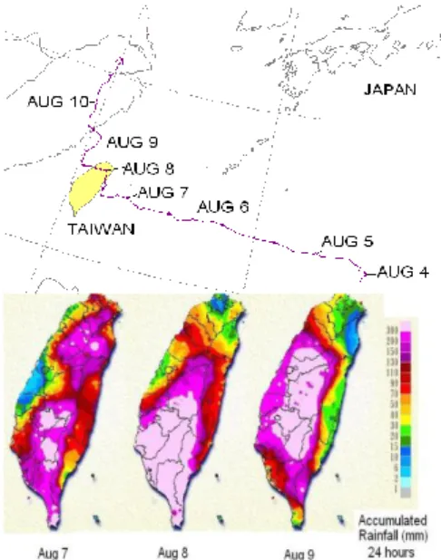
Typhoon Morakot (or Typhoon #8) of August 8, 2009, caused significant loss of life and property in Taiwan. As of September 18, 2009, the National Disasters Prevention and Protection Commission has reported 675 identified deaths; 24 persons are still missing. An economic loss of over US$5 billion has been incurred. Morakot was the most damaging typhoon to make landfall in Taiwan in half a century. Typhoon Morakot had a maximum wind speed of 40m/s and lowest central pressure of 945 kPa. It was classified as a medium strong typhoon (equivalent to a Category 2 hurricane). It brought a new rainfall record of 2777 mm at Alishan (previous rainfall record of 1736 mm was set by Typhoon Herb in 1996). Morakot landed at Hualian, the eastern part of Taiwan, and left at Taoyuan on the western coast. The path of Morakot, its clouds at peak, and the accumulated rainfall from August 7 to August 9, are shown in Figures 1.
The typhoon passed through the central and northern parts of Taiwan. However, torrential rains were primarily concentrated in the south, thus the most heavily damaged areas were in this region. Flooding and landslides led to various types of damage to the infrastructure and geosystems. As one of the counties suffering from severest disasters, Kaohsiung County had many developed regions which passed the environmental impact assessment (EIA) damaged during this event, mainly with slopeland disasters. The occurrence of slopeland disasters such as landslides and debris flows is highly related to geological formations, hydrological conditions, and geographical characteristics. In addition to the rainfall, geological and geographical environmental factors are vital to induce the disasters.
This study integrated the data from Environmental Protection Administration, Executive
The Sixth International Conference on Sustainable Water Environment: Water Infrastructures in Time of Climate Change University of Delaware, Newark, DE, USA, 29-31 July 2010
Yuan and Environmental Protection Bureau, Kaohsiung County to re-evaluate the EIA reports of six developed cases within Bao-Lai hot spring recreation area of Liouguei Township, Kaohsiung County. The reports were tabularized with contents including: description, locations, land-use authority, geological and hydrological datas, slope inclinations and categories for the six developed cases in Bao-Lai hot spring recreation area and the correlation analyses of landslide area and slope gradient distribution were conducted in this study in order to provide new EIA strategy for future development cases under the considerations of potential triggers to induce landslides and debris flows.
2. STUDY AREA AND METHODOLOGY 2.1 Study Area
The study area in this research is located with the Lawnon River basin, one of the most important rivers of Southern Taiwan with river length of 137 km and basin area of 1373 km2. The upstream and midstream are typical valley topography, with erosion valleys, landslides, shoulder ridges, longitudinal and transversal valleys. The downstream was formed along the Lawnon Fault. As the river come to this section, the downward and lateral incision resulted in the riverbank scouring and bank collapse as well as valley widening and riverbank retreating. The topographic characteristics of this section are river terraces, alluvial fans and riverbank slope landslides. The geological formations in this river basin contains Changchikeng Fm.(Cc), Chaujou Fm.(Co), Mt. Bilu Fm.(Ep), Liu-Kuei Fm.(Le) , Lushan Fm. (Ls), Tangenshan Sandstone (Tn), Alluvium Deposits(a) and Terrace Deposits (t). Among them, Chaujou Fm.(Co), Mt. Bilu Fm.(Ep), Changchikeng Fm.(Cc) and Tangenshan Sandstone (Tn) belong to metamorphic rock areas, and
Liu-Kuei Fm.(Le), Lushan Fm. (Ls), Alluvium Deposits(a) and Terrace Deposits (t) belong to sedimentary rock areas [1]. The geological formations of study area are shown in Figure 2.
2.2 Methodology
This research is focused on comprehensively integrated analysis for the disaster reconnaissance and monitoring data for Lawnon River basin, and new considerations on future EIA evaluation principles.
In order to investigate the rainfall-induced landslide conditions within Bao-Lai hot spring recreation area, according to the remarkable rainfall events from 2005 to 2009, the FORMOSAT-2 satellite images were selected to recognize the landslide areas on Bao-Lai Hot spring area of Lawnon River Basin in Southern Taiwan. FORMOSAT-2 satellite launched at May 21, 2004, is a sun-synchronous satellite with the orbit height of 891 km. It has high-resolution and daily revisit imagery and including four bands with 8-m resolution color mode and 2-m resolution panchromatic mode. Colorful image includes blue, green, red and near infrared bands corresponding to the wavelength of 0.45~0.52m, 0.52~0.60m, 0.63~0.69m and 0.76~0.90m, respectively. In addition to the satellite images, lot of reconnaissance works have been executed in the study area for field observation of geological and topographical conditions which may not shown in the satellite images [2].
Figure 1 Path of and Accumulated rainfall due to Typhoon Morakot, August 7 to 9, 2009. (modified from Central Weather Bureau).
This study executed environmental interpretation and disaster sensitivity analysis work which consists of two portions: the first one is geological and topographical zoning analysis of the slopeland disasters (landslides and debris flows) within the study area of Lawnon River Basin. The second one is the correlation analysis between landslide area variation and accumulative rainfall distribution within Bao-Lai area for the previously remarkable rainfall events [3]. Twenty images were selected based on the criterion of before and after the significant rainfall events during the time period of 2005-2009. Satellite image was receipted by the Center for Space and Remote Sensing Research (Taiwan). The preprocessing tasks including geometric correction and radiometric correction were carried out by the Laboratory of Remote Sensing Image Processing and Earth Environment Monitoring, a division of Earth Dynamic System Research Center (EDSRC) of National Cheng Kung University (Taiwan). The landslide regions therefore could be recognized and digitized by man-made process in the geographic information system (GIS). The ambit of digitization is 12 km2 around the Bao-Lai area. Finally the GIS software ArcView 9.2@ was used to calculate the areas of landslide.
To meet the requirement of the potential adjustment of evaluation principles of environmental impact assessment (EIA), this study re-evaluated eight EIA reports in the study area (Figure 3). The comparisons to current conditions were made through the analyses of satellite images for the river basin, debris flow and flooding areas. With the back-calculated area of digitized satellite images, the statistical analysis of landslide scale, slope inclination, geology and land use category were conducted to determine the limitations for regions with high environmental sensitivity and specified land-use purposes [10]. Through this study, it is expected to provide the government appropriate recommendations on homeland restoration and river basin management.
3. RESULTS AND DISCUSSIONS
3.1. Geological and topographical zoning of newborn landslides during typhoon Morakot
Based on the satellite images taken before and after typhoon Morakot, the digitized landslide GIS layers were overlapped and compared to obtain newborn landslide layer, as shown in Figure 4, which was then overlaid with geological and topographical layers to conduct spatial analysis [11], as shown in Figure 5. The total area in this study region is 104252 hectares, and the newborn landslide area after Morakot is 11887 hectares, occupied 11% of the study area. The ratio of newborn landslide area of individual geological formations is highest in Tangenshan Sandstone (Tn), followed by Chaujou Fm.(Co), Mt. Bilu Fm.(Ep), and Changchikeng Fm.(Cc) (Table 1). It was observed that the metamorphic rock area is unstable in this region compared to sedimentary rock areas.
Observed from the slope inclination zoning of newborn landslide areas( Figure 6 and Table 2), the newborn landslides were mainly concentrated on the slope with inclination larger than 15 degrees, which occupied more than 90% of total landslide areas. However, the ratio of newborn landslide area of individual inclination ranges is highest between 6 and 15 degrees (14%). It is obvious that the riverbank scouring is vital to landslides.
Figure 4 Digitized Landslide GIS Layers Figure 3. Studied area of EIA reports [4-9].
3.2. Landslide Scale Variation of Bao-Lai Hot Spring Area
The rainfall data was used to evaluate the hydrological impacts on slopeland disasters for Bao-Lai area in recent 5 years. The data was collected from the rainfall observation stations (owned by Water Resource Agency) within 15 kilometers Bao-Lai village. The data for the remarkable typhoon and rainfall events from 2004 to 2008 was collected for statistical and Isohyet analyses. Total is 13 events. Figure 7 shows the accumulative rainfall distributions in Bao-Lai area during the remarkable events from 2005 to 2008.
In this study, twenty satellite images were selected based on the criterion of before and after the significant rainfall events during the time period of 2005-2009. After some preprocessing tasks, the landslide regions therefore could be recognized and digitized by man-made process in the geographic information system (GIS), as shown in Figure 8. The ambit of digitization is 12 km2 around the Bao-Lai area. The result shows that landslide regions of Bao-Lai area are growing in recent 5 years, even though some small recovery appeared after serious rainfall events. This study conducted reconnaissance of serious rainfall events, search of satellite images, digitization of landslide regions, calculation of landslide area, as well as stream flow rate analysis. The results are shown in Figure 9. The occurrence of landslides has close relation to rainfall, topographic and soil conditions. Based on the observation of Figure 8, before 2008, the variation of rainfall within the study area was not obvious, so that the correlation between rainfall amount (or stream flow rate) was not significant. However, the extreme rainfall brought by Typhoon Morakot in 2009 remarkably increased the scale of landslides. It is evident that global climate change has aggravated the local disaster scale.
Figure 5 Geological Zoning of Newborn Landslide after Typhoon Morakot
Table 2 The Statistics of Slope Inclination Zoning of Newborn Landslides
Inclination Ranges (degrees) Area (ha) Area of Newborn Landslides (ha) Occupation Percentage (%) >30 degrees 55984 6416 11 15~30 degrees 35853 4435 12 6~15 degrees 5882 820 14 < 6 degrees 1 0.02 3 Table 1 The Statistics of Geological Zoning of Newborn Landslides Geological Formations Mark Area (ha) Area of Newborn Landslides (ha) Occupation Percentage (%) Tangenshan Sandstone Tn 2576 451 17 Chaujou Fm. Co 43055 5588 13 Mt. Bilu Fm. Ep 37098 4283 12 Changchikeng Fm. Cc 13149 1401 11 Terrace Deposits t 2851 109 4 Lushan Fm. Ls 466 12 3 Liu-Kuei Fm. Le 1436 20 1 Alluvium Deposits a 3657 21 1
Figure 6 Slope Inclination Zoning of Newborn Landslide after Typhoon Morakot
Figure 7 Rainfall Distribution of the Remarkable Events (2005-2008)
3.3 Analysis of Slope Inclination and Land Use Category
According to the Slopeland Land Use Classification and Identification in Taiwan, slopes are classified into seven levels (L1~L7) based on the inclinations. The classification is shown in Table 3.
After reviewing the EIA reports and the comparisons between pre-disaster and post-disaster images, the results were integrated as shown in Table 4. It is observed that the rainfall amount plays an important role on damage scale. The more intensive rainfall, the more damage. Viewed in land use aspect, the lands with more occupation by security, forestry and non-building are more sensitive to man-made disturbance during development, suffering more environmental impacts.
3.4 Investigation and Analysis of Regions with Highly Environmental Sensitivity and Specified Land Use Restrictions
In terms of development-restricted items, the locations of developed cases were classified as sensitive regions to biology, cultural landscape, resource production, and natural disaster, as well as other legislative development–restricted areas, as shown in Table 5. It shows that the human activities and developing behaviors have a great impact on natural environment, so as to induce disasters and aggravate damage. For example, the larger scale of cut/fill soil mass, the higher potential to induce landslide and debris flow disasters.
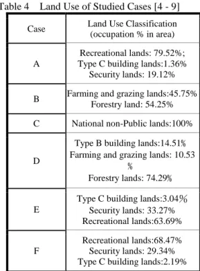
Table 4 Land Use of Studied Cases[4 - 9]
Case Land Use Classification
(occupation % in area)
A
Recreational lands: 79.52%; Type C building lands:1.36%
Security lands: 19.12%
B Farming and grazing lands:45.75%
Forestry land: 54.25%
C National non-Public lands:100%
D
Type B building lands:14.51﹪ Farming and grazing lands: 10.53
﹪
Forestry lands: 74.29﹪
E
Type C building lands:3.04% Security lands: 33.27% Recreational lands:63.69%
F
Recreational lands:68.47% Security lands: 29.34% Type C building lands:2.19% Table 3 Slope Classification
Slope Classification
Slope Gradient (Vertical to Horizontal)
Level 1 Less than 5%
Level 2 5%~15%
Level 3 15%~30%
Level 4 30%~40%
Level 5 40%~55%
Level 6 55%~100%
Level 7 More than 100%
3.5 Analysis of Slope Gradients and Landslide Areas
The impacts of typhoon Morakot in Kaohsiung County are concentrated on slopeland disasters, such as landslides and debris flows. However, the EIA reports of the previous development cases did not take slopeland disaster potential into consideration.
The six developed cases within Bao-Lai hot spring region are all located in Lawnon River basin, and the slope gradient of developed areas are shown in Table 6. Results of landslide contributed by Typoon Morokat wa summarized in Table 7. Among the factors to cause slopeland disasters, slope gradient is extreme critical. The probability of landslide occurrence is highly related to slope inclination. The steeper slopes are more sensitive to slopeland disasters. The regression curve and corresponding R2 for the relationship between landslide areas and slope average gradient is created in Figure 10. As shown in the figure, the R2 is only 0.115, which means poor correlation. Even for the developed region in steeper slope as shown in Figure 11 (i.e. Level 3 and above), the R2 is only 0.647,
which means medium correlation.
After reviewing the study cases, we found that the listed average gradient shown in the previous EIA reports were all calculated with the whole project’s area. In the considerations of permissible building construction under average gradient of 30%, the impacts due to development are supposed to be limited to permissible area for building construction. In other words, the land-use area is that of gradient less and equal to Level 3 slopes. The proposed formula to calculate average gradient of land use areas is shown in Eq. (1):
% 100 %) 5 . 22 % 10 % 5 . 2 ( c b a c b a (1) where
a: occupation (%) of developing area in Level 1 b: occupation (%) of developing area in Level 2 c: occupation (%) of developing area in Level 3 2.5%, 10%, and 22.5%: were the medium value
in Level 1, Level 2, Level 2, and Level 3, respectively.
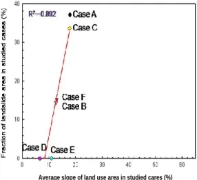
Based on the proposed formula, the calculated average gradients and landslide areas are highly correlated, with R2 of 0.892, which shows that landslide scale is very related to the average gradient of land in use.
Figure 12 Relationship between Landslide Areas and Average Gradient of Land Use Area
Average slope of land use area in studied cares (%)
Slope greater than Level 3 (%)
Figure 11 Relation between Landslide Areas and Average Gradients for L3 slopes and above
Figure 10 Relationship between Landslide Areas and Slope Average Gradient
4 CONCLUSIONS AND RECOMMENDATIONS Based on the analyses and comparisons in this study, the conclusions and recommendations for the causes of disaster damage are made as follows: (1) The degree of damage highly depends on the
rainfall distribution of typhoon events. The regions with intense rainfall suffered more serious damage. Besides, the slopeland disasters concentrated on the regions of metaphoric rocks and steeper slopes.
Table 6 Summary for Slope Gradients of Study Cases in Bao-Lai Regions [4 - 9]. Case Ratio of Level 1 (%) Ratio of Level 2 (%) Ratio of Level 3 (%) Ratio of Level 4 & above (%) Average Gradient of Whole Area (%) Average Gradient of Land Use Area (%)
A 8.65 18.35 60.41 12.59 21.69 17.9 B 10.35 9.1 13.89 66.66 45.76 12.88 C 0.4 30.25 50.06 19.29 23.23 17.73 D 70.2% 5.79 16.97 6.96 7.51 6.59 E 31.67 41.57 26.76 0 10.97 10.97 F 9.73 12.81 13.521 63.93 32.31 12.65
Table 5 The Sensitive and Restricted Development Properties of Study Cases [4 - 9].
Items Case A Case B Case C Case D Case E Case F
1. Cut/Fill Regions X ● ● ● ● ●
2. Slag Wastelands X X X X X X
3. Slopelands ● ● ● ● ● ●
4. Security and Forestry lands X X X X X X
5. Mining Regions X X X X X X
6. Tourism Scenic Regions ● ● ● ● ● ●
7. Land Use Restricted Regions X X X X X X
8. Water & Soil Conservation Regions X X X X X X
9. Regions of Riverside, Landsubsidence, Seawater Inwelling, Groundwater and Flood Plain Restriction
X X X X X X
10. Regions of Drinking Water Source or Water
Quality Protection X X X X X X
11. Protection Regions of Tap Water Source and Quality
● ● ● ● ● ●
12. Regions of Water Pollution Restriction ● ● ● ● ● ●
Table 7 Fractions of Landslide Area in Bao-Lai Hot Spring Area
Case Land Use Area (ha)
Landslide Area (ha) Ratio of Landslide Area by Morakot
(%) Before Disaster After disaster
Satellite Image (2008/10/08) Satellite Image (2009/08/24)
A 4.29 0 1.59 37.06 B 2.20 0.22 0.56 15.45 C 3.83 0 1.29 33.68 D 0.39 0 0 0.00 E 1.09 0 0 0.00 F 1.64 0 0.24 14.63
(2) The lands with more occupation by security, forestry and non-building are more sensitive to man-made disturbance during development, suffering more environmental impacts. And human activities and developing behaviors have a great impact on natural environment, so as to induce disasters and aggravate damage.
(3) The probability of landslide occurrence is highly related to slope inclination. However, the average gradients shown in previous EIA reports were all calculated with the whole project’s area, which showed low correlation to damage scale,
unable to forecast the damage. Considering the regulations of building and development, it is proposed to calculate the average gradient with real area in use, then appropriately to predict landslide scale.
(4) The EIA reports of the previous development cases did not take slopeland disaster potential into consideration. It is recommended to involve the viewpoints of geotechnical and soil & water conservation experts to the future EIA report evaluations.
The localized extreme rainfall due to global climate change has a serious impact on disaster aggravation. The central and local governmental agencies should have corresponding measures of disaster prevention and reduction to the development of high risk potential areas.
REFERENCE
[1] K. C. Sung, C. W. Lin, W. H. Lin, W. C. Lin, No.51 of Taiwan Geology Map – Chia Hsien, (1:50000 ) , Central Geological Survey, MOEA, Taiwan, 2000.
[2] H. L. Lien, J. M. Kao, C. W. Lee, Final report of homeland restoration and environmental investigation of Kaohsiung Area damaged by Typhoon Morokat, Environmental Protection Administration, Executive Yuan, Taiwan, 2009. [3] C. L., Shieh, Y. S. Chen, Y. J. Tsai, and J. H. Wu,
International Journal of Sediment Research Vol. 24, pp. 177-188, 2009.
[4] Environmental Impact Assessment Report of Case A, Environmental Protection Administration, Executive Yuan, Taiwan, 2007.
[5] Environmental Impact Assessment Report of Case B, Environmental Protection Administration, Executive Yuan, Taiwan, 2007.
[6] Environmental Impact Assessment Report of Case C, Environmental Protection Administration, Executive Yuan, Taiwan, 2007.
[7] Environmental Impact Assessment Report of Case D, Environmental Protection Administration, Executive Yuan, Taiwan, 2007.
[8] Environmental Impact Assessment Report of Case E, Environmental Protection Administration, Executive Yuan, Taiwan, 2007.
[9] Environmental Impact Assessment Report of Case F, Environmental Protection Administration, Executive Yuan, Taiwan, 2007.
[10] C. Y. Chen, Geomorphology, Vo. 105, pp. 355-365, 2009.
[11] P.W. Tsai, C. C. Ding, The New Geology Information System - Investigation of ArcView 9.X, Hitron Technologies Inc., Taiwan, 2005.
![Figure 4 Digitized Landslide GIS Layers Figure 3. Studied area of EIA reports [4-9].](https://thumb-ap.123doks.com/thumbv2/9libinfo/7412717.104046/3.892.469.781.439.1095/figure-digitized-landslide-gis-layers-figure-studied-reports.webp)

![Table 6 Summary for Slope Gradients of Study Cases in Bao-Lai Regions [4 - 9]. Case Ratio of Level 1 (%) Ratio of Level 2 (%) Ratio of Level 3 (%) Ratio of Level 4 & above (%) Average Gradient of Whole Area (%) Average Gradient of](https://thumb-ap.123doks.com/thumbv2/9libinfo/7412717.104046/8.892.137.731.127.449/table-summary-gradients-regions-average-gradient-average-gradient.webp)
