doi:10.6342/NTU201704041
國立臺灣大學理學院地理環境資源學系 碩士論文
Department of Geography College of Science
National Taiwan University Master Thesis
如何找路?覓路測試環境、路線知識、
心理地理空間能力與覓路表現的關係 How to find your way?
Relationship between wayfinding testing environments, route knowledge, psychological geospatial abilities and
wayfinding performance
周峻民 Chun-Min Chou
指導教授:賴進貴博士 Advisor: Jinn-Guey Lay, Ph.D.
中華民國 106 年 8 月
August, 2017
doi:10.6342/NTU201704041
i
口試委員審定書
doi:10.6342/NTU201704041
ii
謝誌
耶和華是我的牧者,我必不致缺乏。他使我躺臥在青草地上,領我在可安 歇的水邊。他使我的靈魂甦醒,為自己的名引導我走義路。我雖然行過死 蔭的幽谷,也不怕遭害,因為你與我同在;你的杖,你的竿,都安慰我。
(詩篇23:1-4)
四年前,決定要當地理老師而考進地理所,開始一段人生中迎接新挑戰的時期。
感謝上帝,愛我、引導我,不論在修習教育學程、地理專業課程,或學術研究上,
都有上帝安排的幫助與美意。
感謝指導教授賴進貴老師。在學術研究上的指導,常常擴展我的學術視野,同 時提供精準的研究問題定位;在教程中的教導,老師讓我瞭解地理老師該有的胸懷 與專業能力。謝謝兩位口試委員,林楨家老師與郭柏呈老師,對於論文的問題切入 與後續修改,給了許多中肯且有啟發性的意見。
感謝心理所期間給過我指導的老師。葉怡玉老師培養我學術研究的基本認知 概念與邏輯思考方法;連韻文老師給予了學術知識如何與生命結合的眼光;陳建中 老師開啟了科學研究的新視野。
四年研究生涯中曾一起打拼的伙伴,佳融、明清、品潔、崇安、稚倫、怡人、
慶燁、羚翔、蕙君、婷玉、淑君,跟你們常常的討論,可以讓我不斷思考我的研究 的改進方向,萌發更好的想法。研究室的助理們,玉臨、淑敏、昊妤、原華、昶安、
鈺婷、偉嘉,讓研究室成為一個又溫暖又歡樂的工作場所。感謝父母,給我自由發 展、探索自我的空間。感謝團契的弟兄們,常常的關心與代禱,讓我力上加力。
地理所的四年,還受過許許多多的幫助。從大學部同學而來、從行政大姊的關
懷而來、從教育學程的所有老師而來,無法一一提名,讓我向大家道聲:「謝謝你
們每一個人。」
doi:10.6342/NTU201704041
iii
摘要
空間認知對人類是重要的素養之一。空間認知使我們可以辨認路標、找出空間 樣態,以及進行空間的決策。在過去研究中,覓路被廣為使用來評估空間認知能力。
在覓路過程中,人類必須記住目的地、必須掌握路徑位置,並且確認周圍環境來決 定正確方向,然後不斷朝向目的地前進。因此,心理地理空間能力以及環境知識在 覓路過程中扮演重要的角色。此外,一種新的覓路測驗介面,虛擬環境,因為其花 費成本比起真實環境找路測驗來的低,而被許多研究所採用。然而,目前沒有研究 測試兩種介面上的覓路行為是否一致。
利用Google 地圖 API,我們創造了一種新的虛擬環境介面:Google 街景。在
本研究中,將同時測試真實環境與街景介面下的覓路行為。除此以外,研究者也操
弄不同的環境知識描述(覓路線索),以測試環境知識對覓路行為的影響。覓路線
索有三類:方向描述、地圖描述,以及伴走描述。在伴走線索描述中,實驗者陪伴 受試者走過一次覓路路徑,稍後受試者自己反向走過一次路徑。利用便利取樣,三
種覓路線索組別各有15 位受試者。受試者根據所屬組別給予覓路線索,並完成真
實環境以及街景環境的覓路。接著完成一系列的線上測驗組合,包括覓路策略、心 理旋轉、工作記憶、方向感,以及地理空間思考能力的量表。
結果顯示,真實環境以及街景環境中的覓路行為是一致的,表示街景上找路也 可以達到足夠的生態效度。不同的覓路線索對覓路表現也有不同的影響。伴走線索 組的受試者,比起地圖線索或方向線索的受試者,花更少的時間。這個發現與認知 拼貼(Tversky, 1993)的假設一致。在認知拼貼中,空間知識並非像是地圖一樣,而 比較像是零碎的空間資訊的集合,這些資訊可以有空間、文字、或聲音等不同形式。
在伴走線索組中,伴走過程中的不同形式的資訊,有助於更快速並更正確找到目的 地。此外,覓路線索與心理地理空間能也有交互作用。地圖線索組的受試者,其覓 路表現會與地理空間思考能力、心理旋轉以及視覺空間工作記憶有相關。伴走線索 組的受試者,覓路表現則與心理旋轉及方向感有相關。顯示人們會因為對應不同的
doi:10.6342/NTU201704041
iv
覓路環境知識,而使用不同的心理地理空間能力。當給予地圖線索,讀圖能力、旋 轉能力及空間記憶能力是重要的。相對的,若給予伴走線索,則方向感的好壞會決 定覓路表現。
關鍵詞:空間認知、覓路、Google 街景、心理地理空間能力、視覺空間工作記憶、
方向感
doi:10.6342/NTU201704041
v
Abstract
Spatial cognition is an essential literacy for human beings. It enables people to recognize landmarks, identify spatial patterns, and make spatial decisions. To evaluate spatial cognitive abilities, wayfinding has been widely adopted in previous studies. In the process of wayfinding, one has to keep destination in memory, to keep track of path, to decide whether or not make turns by monitoring surrounding environments, and to head to the destination. Therefore, psychological geospatial abilities and knowledge about the environment are of concern in wayfinding process. Moreover, a new wayfinding testing environment, i.e. virtual environment, gains popularity because of it saves time and money than real-world environment does when collecting data. However, no studies have tested whether the wayfinding behaviors in the virtual environments are parallel to those in real-world settings.
Taking advantage of the Google Maps API, a new virtual environment interface, the Google Street View, was adopted in this study. Wayfinding behaviors in both real-world and google street view settings were compared simultaneously in our study. Three different types of knowledge of environment, i.e. wayfinding cues, were manipulated.
Direction cue, map cue and walk cue (participants were accompanied walking through the wayfinding route) were varied across different groups of participants to test the cue effect. A total of 45 participants were recruited through convenient sampling and were
doi:10.6342/NTU201704041
vi
randomly assigned to either of the 3 groups. Participants were given different types of wayfinding cue according to their group and they completed wayfinding test in the sequence of real-world setting and then street view setting. Finally, an online test battery which consisted of wayfinding strategies, mental rotation, working memory, sense of direction, and geospatial thinking abilities scales was given.
The results showed that behavioral patterns were similar between real-world and street view settings, suggesting that street view interface had ecological validity as real- world environment did. Types of wayfinding cues had differential effect on wayfinding performance. Participants in the walk cue group spend less time than those in map cue group or direction cue group did. These findings are consistent with the cognitive collage hypothesis (Tversky, 1993), in which spatial knowledge are represented as a fragmented collection of bits in spatial, textual, or acoustic forms rather than a detailed map. In the walk cue group, different formats of information during accompanied walking through the wayfinding route are beneficial to find the correct destination.
Interaction between wayfinding route cue types and psychological geospatial abilities was observed in this study. Wayfinding performance in map cue group was correlated with geospatial thinking abilities, mental rotation ability, and the capacity of visuospatial working memory. On the other hand, wayfinding performance in walk cue group was correlated with mental rotation ability and sense of direction. The results
doi:10.6342/NTU201704041
vii
indicated that participants exercised different psychological geospatial abilities according to their knowledge about the wayfinding environments. When map cue is given, map reading skills (geospatial thinking abilities and mental rotation) and capacity of visuospatial information are required. When walk cue is given, sense of direction is related to wayfinding performance.
Keywords: spatial cognition, wayfinding, google street view, psychological geospatial abilities, visuo-spatial working memory, sense of direction
doi:10.6342/NTU201704041
viii
Table of Contents
口試委員審定書 ... i
謝誌 ... ii
摘要 ... iii
Abstract ... v
LIST OF FIGURES ... xi
LIST OF TABLES ... xiii
Chapter 1. Introduction ... 1
1.1 Background and Motivation ... 1
1.2 Objectives and Research Questions ... 3
Chapter 2. Literature review... 6
2.1 Spatial cognition ... 6
2.1.1 The development of spatial cognition ... 6
2.1.2 The acquisition of spatial knowledge ... 7
2.2 Visual-spatial Working memory ... 9
2.3 Wayfinding ... 13
2.3.1 Definitions of Wayfinding ... 13
2.3.2 Spatial Knowledge in Wayfinding ... 15
2.3.2.1 Landmark, route and survey knowledge and map reading ... 15
doi:10.6342/NTU201704041
ix
2.3.3 Wayfinding testing environment ... 16
2.3.3.1 Real-world Outdoor environment ... 16
2.3.3.2 Virtual environment: Google Street View ... 21
Chapter 3. Research Method ... 26
3.1 Research design ... 26
3.2 Participants ... 28
3.3 Design and materials ... 30
3.3.1 First phase: Wayfinding testing in real-world environment ... 33
3.3.2 Second phase: Wayfinding testing in Google Street View ... 37
3.3.3 Third phase: online test battery ... 41
3.4 Procedure ... 48
Chapter 4. Results and Discussion ... 54
4.1 Summary of variables in this study ... 54
4.2 Descriptive statistics ... 56
4.2.1 Demographic variables ... 56
4.2.2 Wayfinding performance variables ... 56
4.2.3 Psychological geospatial related variables ... 57
4.3 Performance comparison between real-world and Google Street View wayfinding testing environments ... 58
doi:10.6342/NTU201704041
x
4.4 Cue type effect on wayfinding performance ... 60
4.5 Variables of interest in online survey ... 62
4.6 Interactions between knowledge of the route and psychosocial geospatial abilities ... 66
Chapter 5. Discussion ... 67
5.1 General discussion ... 67
5.2 Limitations and future work ... 69
References ... 71
Appendix A. Wayfinding strategy questionnaire ... 79
Appendix B. Santa Barbara Sense of Direction Scale (SBSOD) ... 80
Appendix C. Geo-spatial thinking ability test, GSTAT ... 81
Appendix D. Instructions of the map-cue condition ... 96
Appendix E. Instructions of the direction-cue condition ... 98
Appendix F. Instructions of the walk-cue condition ... 100
doi:10.6342/NTU201704041
xi
LIST OF FIGURES
Figure 1 The multistore model of memory (Atkinson & Shiffrin, 1968). ... 9
Figure 2 The Working memory model by Baddeley and Hitch (1974) ... 10
Figure 3 Screening test for participants recruitment ... 29
Figure 4 Schematic diagram of a two-factor mixed experiment design. ... 31
Figure 5 Partial NTU campus map that participants in map-cue condition receive 34 Figure 6 List of direction instruction in the direction-cue condition ... 35
Figure 7 The record sheet provided in the walk cue condition. ... 36
Figure 8 Sample screen image of the Google Street View introduction video clip.37 Figure 9 Sample screen image of Google Street View. ... 38
Figure 10 Wayfinding route map in map-cue condition ... 39
Figure 11 List of direction instruction in the direction-cue condition ... 40
Figure 12 sample screen image of the questionnaire of wayfinding strategies ... 42
Figure 13 Sample screen image of rotations task ... 43
Figure 14 Sample screen image of monkey ladder task ... 44
Figure 15 Sample screen image of digit span task ... 45
Figure 16 Sample items of Santa Barbara Sense of Direction Scale ... 46
Figure 17 sample items of GSTAT ... 47
Figure 18 Schematic flowchart of experiment procedure ... 50
doi:10.6342/NTU201704041
xii
Figure 19 Sample screen image of the online test battery ... 51 Figure 20 Scatter plot of elapsed time in real-world and street view settings. Line of best fit is indicated. ... 59 Figure 21 Scatter plot of number of errors in real-world and street view settings. Line of best fit is indicated. ... 60 Figure 22 Mean elapsed time under different cue types in real-world wayfinding.
Error bar is indicated. ... 61 Figure 23 Mean elapsed time under different cue types in street view wayfinding.
Error bar is indicated. ... 61
doi:10.6342/NTU201704041
xiii
LIST OF TABLES
Table 1 Materials used in 3 wayfinding cue types during 3 phases ... 32
Table 2 list of variables in experiment method (phase 1 and 2) ... 54
Table 3 list of variables in survey method (phase 3) ... 55
Table 4 Descriptive statistics for age and frequency of using navigation aid ... 56
Table 5 Descriptive statistics for wayfinding performance variables ... 56
Table 6 Descriptive stat for spatial cognition related variables ... 57
Table 7 statistical results of simple regression analysis of elapsed time of real-world wayfinding on each variable in online survey ... 63
Table 8 statistical results of simple regression analysis of elapsed time of Google Street View wayfinding on each variable in online survey ... 65
doi:10.6342/NTU201704041
1
Chapter 1. Introduction 1.1 Background and Motivation
The scenario described below happens on a daily basis that you might be familiar with. In your places, whether they are office building complexes or campus areas, you find someone holding a map, looking around, rotating the map in order to locate themselves on the map. After spending a few moments trying and sweating, he or she would come to you and ask for directions. Now it’s your turn to make a decision. Whether you are going to give him/her detailed verbal directions of the route to the destination?
Or you will draw a route map for them? And still another option is that you would choose to lead him/her to the destination.
The above scenario depicts the importance and complexity of wayfinding, which means the process of traveling from the starting point to the destination (Golledge, 1999a).
In our daily lives, we all have to make movement between two or more places, whether
they are in familiar or in unfamiliar environments. Getting lost in an unfamiliar environment during wayfinding would result in additional cost of time and money, and sometimes even at the cost of life.
Wayfinding is an important daily practice for all humans, but successful wayfinding is by no means an easy task. Before wayfinding, the starting point and the destination must be decided in advance. Sometimes, however, the destination is not clear or specific.
doi:10.6342/NTU201704041
2
For example, the destination might be just a name of a restaurant without address, which means the wayfinding route between the starting point and the destination could not be predefined. Wayfinders therefore would require navigational aids, e.g. maps or GPS devices, to assist in deciding wayfinding route. Second, during wayfinding process, wayfinders have to monitor the environment and the location of themselves to ensure they are on the decided route. Once getting lost, wayfinders have to relocate themselves by checking on the navigational aids or asking help from others. Finally, correction recognition of the destination is the last while the most important step in wayfinding.
Mistakes in any of the elements of wayfinding process would make successful arrival to the destination impossible.
Given the significance of wayfinding, it is not surprising that multiple disciplines address their research in wayfinding. For example, psychologists have investigated the spatial cognition of wayfinding. Psychological studies have either focused on the developmental stages of spatial cognition, or on the mental representations of textual and graphical form of spatial information, or on the mental processing capacities.
Environmental scientists, on the other hand, have been interested in the relationship between environmental characteristics and wayfinding performance. They have provided different types of geographical features and quantitative measures of the complexity of street shapes, which have been potentially related to wayfinding. Also pedestrian flows
doi:10.6342/NTU201704041
3
have been studied to better design building structures.
With the advancement of technology, wayfinding testing environments have changed a lot. Virtual environment (VE) techniques allow images of real-world or computer graphics to project on computer screens. Although virtual environment studies have higher efficiency of time and better experimental controls than outdoor real-life experiments of wayfinding, the ecological validity of virtual environment studies is not yet tested. Thus whether the results from the virtual environment studies are applicable to real-world wayfinding behavior remains unknown.
1.2 Objectives and Research Questions
Wayfinding is never an easy task for many people. In the process of wayfinding, factors such as environmental characteristics, prior knowledge about the traffic network, and cognitive properties of wayfinders all take part in. That is why wayfinding is a popular and practical issue and attracts academic research interest from various study fields.
In order to understand why and how wayfinders may succeed or fail in finding the destination, we tried to investigate wayfinding from a broader perspective. Previous studies have taken one perspective between the psychological or environmental approach.
To achieve a more comprehensive understanding of complex wayfinding behavior, it is necessary to integrate both psychological and environmental factors in one study.
doi:10.6342/NTU201704041
4
Therefore, the first study objective aims to systematically test the role of psychological and environmental factors and the interactions between the two factors.
The second study objective is related to the first objective and addresses a more practical issue: how to give directions to wayfinders that ask for directions. Giving directions is perhaps not as easy as you might think. There are several types of direction guides, such as verbal instructions and map drawing. Previous studies, however, have never distinguish the effects of different direction guides. In this study, different types of information of the same wayfinding route were tested and suggestions of how to give directions were made.
The third study objective concerns about different wayfinding testing environments.
Computer interface or virtual environment has gained its popularity in wayfinding research because of low cost of time and money comparing to real-world environment.
Although virtual environment has many advantages, whether human subjects behave in the virtual environment as the same pattern as they do in real-world environment has not yet tested. We would like to bridge the gap between different testing environments and develop a potential online training course of improving wayfinding performance.
Based on the research objectives stated above, here are the core questions of wayfinding that will be investigated in this study.
doi:10.6342/NTU201704041
5
First, are the wayfinding studies on different interfaces comparable? Could the study results on computer interface extend to real-world wayfinding behavior?
Second, what is the underlying cognitive knowledge of wayfinders? To be specific, how do psychological geospatial abilities interact with knowledge of the environment?
Third, would the strategies adopted by individuals during wayfinding process make differences? How to we give wayfinders more effective cues according his/her own preferable strategies?
doi:10.6342/NTU201704041
6
Chapter 2. Literature review 2.1 Spatial cognition
2.1.1 The development of spatial cognition
What is space and how do human shape the spatial concept? Researchers once take the anthropological and philosophical approach to study. Egenhofer and Mark (1995) take advantage of naturalistic observation and literature review and 12 elements or presumptions of human spatial cognition are identified. Among the 12 elements, some key observations do have important application in daily life. For example, because humankind thinks the earth is flat, it is troublesome for them to understand the shortest distance from New York to Tokyo is through the North Pole. The follow-up study by Downs and DeSouza (2006) suggest that the flat earth myth might come from the habit that humans much often use flat map. As for element no. 7, it provides the evidence that human may change their knowledge about a geographical feature. For example, New York could be perceived either as a point or an area, depending on the context.
The classical work by Lynch (1960) have identified geographical space into 3 categories: zero-dimension, one-dimension and two-dimension. Zero-dimension space includes nodes and landmarks; One-dimension space includes routes and borders; Two- dimension space includes areas. Empirical studies prove that humankind also have the same structured spatial cognition (Hirtle & Jonides, 1985). When it comes to the spatial
doi:10.6342/NTU201704041
7
structure studies, landmarks are the main focus. Sorrows and Hirtle (1999) suggest a theory of landmarks, which divides landmarks into 3 categories. The fist category is called the visual landmarks, which are visually salient. The second category is structural landmarks. They might not be visually distinctive but are crucial in wayfinding. And the third category is cognitive landmarks, which have unique meanings. The theory of landmarks is supported by the studies by Winter and Raubal (2004). Empirical evidence indicates that a high ratio of subjects prefer the building with highest visual and semantical salience as a landmark to signal a right turn in a complex street scene.(Egenhofer & Mark, 1995; Freksa, Habel, & Wender, 1998; Hirtle, 2011)
2.1.2 The acquisition of spatial knowledge
Mark, Freksa, Hirtle, Lloyd, and Tversky (1999) posit three ways to acquire spatial knowledge. The first is through actual exploration. Humans are able to acquire spatial information by different modalities, such as vision, hearing, or touching, etc. But the
process of exacting geographical knowledge from locomotion is indirect (Montello, 1997). With sensorimotor exploration in the environment, not only geographical features such as turns, landmarks, intersections, and distances but travel time, travel effort and aesthetic evaluation of one place are built.
Alternative media such texts, pictures, and charts is the second way to gain spatial knowledge. Subjects ae able to construct a mental model from text information of a place
doi:10.6342/NTU201704041
8
and the contents are similar to those constructed by studying maps of the same scene (Taylor & Tversky, 1992). The retention time of spatial text memory is, however, shorter than that of spatial pictorial memory (Federico & Franklin, 1997).
The third way to gain spatial knowledge is through virtual environment (VE).
Navigation through VE mimics experience of movement through space but may not provide full sensory experience to the traveler. Though perceptual interactions with the environment are often lacking, VE simulations and current GISs are closer to an in interactive version of map use.
doi:10.6342/NTU201704041
9
2.2 Visual-spatial Working memory
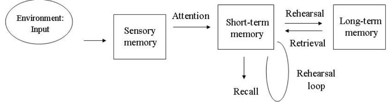
The study of memory has been an important and popular research issue in psychology, neuroscience etc. In 1968, Atkinson and Shiffrin (1968) propose a well- known memory model, the multistore model of memory (Figure 1). This model follows the idea of “information processing”, that is, human memory system is like a computer with an input, process and output. In the multistore model of memory, environmental stimuli enter human through modalities such as vision and hearing. Sensory information then enters short-term memory through a resource-limited attention window. Information is transferred into long-term memory only when it is rehearsed. Else, information will be lost due to information decay or displacement by subsequent stimuli.
Figure 1 The multistore model of memory (Atkinson & Shiffrin, 1968).
Adapted from McLeod (2007)
In the model of Atkinson and Shiffrin (1968), short-term memory acts like a passive storage with limited capacity and storage time. It is, however, oversimplified and later studies have elaborated the concept of STM to working memory.
doi:10.6342/NTU201704041
10
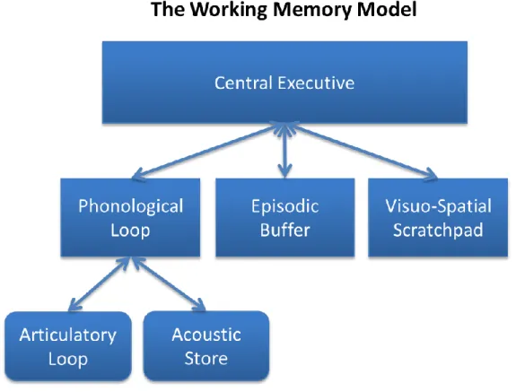
Baddeley and Hitch (1974) propose the working memory model. In this model, STM is replaced by working memory, which has several subsystems (Figure 2). Instead of only one single storage of information, there are different subsystems for different types of modalities. Phonological loop deals with verbal or spoken material while visuo-spatial scratchpad deals with information in visual or spatial forms. Above the 2 subsystems, central executive regulates the information flow into the subsystems and allocates the attention resources between the two subsystem.
Figure 2 The Working memory model by Baddeley and Hitch (1974) Source: Cheese360, URL:
https://commons.wikimedia.org/wiki/File:Baddeley_and_Hitch%27s_Working_Memory_Model.png under Creative Commons Attribution-Share Alike 3.0 Unported
doi:10.6342/NTU201704041
11
Several studies have been testing the properties of the structure of human spatial cognition and its role in wayfinding. As Montello and Freundschuh (2005) suggest, wayfinding involves selection, maintenance, filtering and updating representations in our memory to make correct decisions. The key player in wayfinding is spatial working memory. However, there is very few, if any, studies dedicate to test the role of spatial working memory in wayfinding. Hence we attempted to test whether spatial working memory and wayfinding performance were correlated. Two representative psychological tasks, mental rotation and monkey ladder, were adopted to measure the spatial working memory.
Hund and Gill (2014) test interaction between the wayfinding direction cue types (route or survey) and the memory demand (memorized cues or piecemeal cues) in indoor environments. When participants are asked to memorize the direction cues, cue types do not make a difference. When participants are given piecemeal cues, route cues group
spend less time and made fewer errors than the survey cues group do.
The role of visual-spatial working memory (VSWM) in the process of wayfinding has been investigated by several studies. Bosco, Longoni, and Vecchi (2004) have participants study a simplified map of a scenic spot in Rome and later receive a test battery of 8 spatial knowledge tests including landmark knowledge, survey knowledge, and route knowledge of the studied map. Another 4 VSWM tasks are given and statistical analysis
doi:10.6342/NTU201704041
12
shows a strong relationship between the spatial knowledge and VSWM.
Meilinger, Knauff, and Bulthoff (2008) examine the role of working memory in wayfinding using a dual task paradigm. Participants learn two routes through a virtual environment of a city while completing visual, spatial, or verbal secondary tasks or no secondary task. At test, participants are asked to retrace the routes to find goal locations.
Performance is hindered with verbal and spatial secondary tasks, but not with the visual secondary task, indicating that both verbal and spatial working memory are required for wayfinding.
doi:10.6342/NTU201704041
13
2.3 Wayfinding
2.3.1 Definitions of Wayfinding
Space is around us and thus spatial cognition is an essential literacy for human beings.
It enables people to recognize landmarks, identify spatial pattern, and make spatial decisions. Purposeful navigation between places is perhaps the most prominent real world application of spatial cognition. Wayfinding, i.e. navigation in environment space, is directed to distant destinations or distant space, respectively. Golledge (1999a) defines wayfinding as “the process of determining and following a path or route between an origin and destination.” And the crucial aspect of wayfinding is that paths to the destination(s) are not always available from direct perception at the origin of travel. Three levels of spatial knowledge have been distinguished by Golledge (1999a) in his studies. At the first level, people gain the spatial knowledge about a point in space (e.g., a landmark, a destination). At the second level, people know about a sequence of points (i.e., a path to a destination, often referred to as route knowledge). And at the third level, people have the knowledge about an area (i.e., knowledge about the spatial relation of at least two points, often referred to as survey knowledge). Since then, route and survey knowledge have been the research focus of wayfinding studies. The properties of landmarks, path, and area have been of great interest.
Montello and Freundschuh (2005) defines navigation as consisting of two
doi:10.6342/NTU201704041
14
components, locomotion and wayfinding. Locomotion refers to navigation behavior in response to current sensory-motor input of the immediate surrounding and includes tasks such as steering, obstacle avoidance, and the approach of a visible object in vista space.
The term wayfinding subsumes a number of navigation tasks that share certain common features: they require decision making and/or planning processes, involve some representation of the environment and aim at reaching destinations beyond the current sensory horizon. Typical wayfinding tasks are, for example, search, exploration, and route planning. Therefore, the process of way-finding, which is about navigating from one point to a destination along road networks, requires integration of different cognitive ability.
Specifically, one has to keep destination in memory, keep track of path, decide direction by checking surrounding environment, and head to the destination. Human perception and memory play an important part in wayfinding.
Downs and Stea (1973) suggest that successful wayfinding consist of four steps. The
first step is orientation. Wayfinders identify “where am I in the surrounding and related to nearby landmarks and destination.” Second step is route selection. Wayfinders choose a route that will lead to the destination. Third step is route control. Wayfinders constantly monitor and control the wayfinding route and make confirmation that individual is following the selected route. The forth step is recognizing destination. Wayfinders have the ability to recognize that they have reached the destination
doi:10.6342/NTU201704041
15
From the literature reviewed above, we could give a common definition of wayfinding: destination guided motion (Brunyé, Mahoney, Gardony, & Taylor, 2010) due to the union of spatial and environmental cognition to allow people to make a series of decisions using cognitive abilities to find your way through the build or natural environment, with or without the use of external device such as maps or GPS systems (Fewings, 2001; Golledge, 1999b).
2.3.2 Spatial Knowledge in Wayfinding
2.3.2.1 Landmark, route and survey knowledge and map reading
Hirtle, Richter, Srinivas, and Firth (2010) have identified 3 main problems in wayfinding. The first is matching problem. Wayfinders must know their position and azimuthal directions and they have to match where they are on the map. Thus it is also called the “where am I” problem. The second problem is concerning about the spatial complexity. In the study of Tenbrink and Winter (2009), subjects are assigned to perform
a route planning task. They have to give enough information about the route, e.g. where to make turns, distance between 2 landmarks, to enable others to follow. The complexity of their routes is calculated and compared with online map route planning results. The results show that subjects tend to give less information of a simple route while giving detailed information of a complex route. The third problem is expectation or knowledge about a place. When the knowledge background of wayfinders varies, the expectations of
doi:10.6342/NTU201704041
16
road networks will differ. Thus when wayfinders are in a stranger place and their knowledge doesn’t apply, wayfinding performance would be impaired.
2.3.3 Wayfinding testing environment
Wayfinding performance has been tested in various environment settings, including paper-and-pencil tests, virtual environment settings, and real-world indoor or outdoor environments. Paper-and-pencil tests have the advantage of economic execution. Real- world field tests are often time-consuming and money-demanding while the ecological validity outperforms other testing settings. Virtual environment settings might be a compromise between the above two, but additional technological costs have to be covered.
Taking advantage of Google street view, we were able to establish a virtual environment with even real street views. Wayfinding test on Google street view enables researchers to collect a large sample at the same time at minimum cost while keeping reliable ecological validity.
2.3.3.1 Real-world Outdoor environment
Comparing to indoor testing environment, wayfinding studies in real-world outdoor environment are very few, if any. With the constraint of time and money, the number of experiment participants is limited. When it comes to safety concern, real-world large scale field study is difficult for investigators to set up. It is, however, clear that the ecological
doi:10.6342/NTU201704041
17
validity of real-world environment testing is guaranteed. Since wayfinding is a problem in daily practice, the closer the study setting to real world situation, the better ecological validity would be.
Boumenir, George, Rebillard, Valentin, and Dresp-Langley (2010) conduct experiments in a large, park-like cemetery area. This study area features a complex network of different size of path and plenty of landmarks such as chapel, fountains, road name signs and information panels. Twenty-four participants, none of whom are familiar with the study area, are recruited and equally divided into 3 groups. The amount of spatial information given about the wayfinding route before field test is manipulated across 3 groups. The results show that virtual guided condition, in which participants form incorrect distance perception, results in worst performance.
Nori, Grandicelli, and Giusberti (2009) measure wayfinding performance in a botanical garden of moderately dense wooded area. Forty participants are accompanied walking from starting point to the destination and then are asked to followed the route in the opposite direction without any assistance. Though the wayfinding route distance is short (about 360m), route reversal and large number of turns (14 turns are required) make the route difficult. The results suggest that participants with higher visuo-spatial working memory (WSWM) make fewer errors, pause less frequently and finish the route in a shorter time than those with lower VSWM do.
doi:10.6342/NTU201704041
18
Only two studies have investigated real-world outdoor wayfinding in road network environment. Meilinger and Knauff (2008) test the impact of different types of spatial knowledge on wayfinding in urban road network. Twelve participants are given verbal direction (route knowledge) and route map (survey knowledge) respectively to either short route or long route condition. After wayfinding test, several posttests are given to exam how route and survey knowledge are represented in memory. Their study reports null relationship between spatial knowledge and wayfinding. Performance of verbal direction and route map condition do not differ in wayfinding performance and post spatial knowledge test scores. Meilinger and Knauff (2008) postulate that participants use the strategy to translate the map into verbal detections and that small sample size might attribute to the results.
Employing the dual-task paradigm, Garden, Cornoldi, and Logie (2002) study the differential influence of the two subcomponents of working memory, which are verbal
working memory and visuo-spatial working memory, on wayfinding performance. The study site is a road network in a medieval European town featuring short, narrow, curvilinear streets and various cues such as road sign and different buildings. Thirty participants are led by the experimenter through the wayfinding route and then are asked to follow the route exactly in the same way. Twenty of the participants are assigned to experimental group and are required to perform a secondary concurrent task, either an
doi:10.6342/NTU201704041
19
articulatory suppression task or a spatial tapping task respectively for 2 different routes.
The results show that only participants who report using a survey representation during wayfinding suffer a concurrent visuo-spatial dual task loss. On other hand, participants that are less likely to build survey representation are more affected by a concurrent verbal dual task loss. This study suggests that in real-world environment, different wayfinding strategies adopted by individuals might play an important role in the nature of their mental representations.
Taking advantage of military college graduation requirement, Malinowski and Gillespie (2001) have 978 sophomore students perform orienteering in a woodland terrain.
The study site is a hilly forest area with some clearings and elevation difference between the lowest and highest points is about 90 m. Within this area, eight 6 km orienting lanes are established and in each orienting lane ten points were positioned. Participants receive an intensive 3-day training program on map reading, compass usage, terrain visualization
and distance estimation. On the final day, participants are required to use a map, a compass, and a brief terrain visualization cue to find each of the ten points in a 4-hour period. The results indicate that, like previous small scale laboratory studies, wayfinding performance is related to gender, math ability, and map-use skills.
In addition to wayfinding performance of adult participants, a few researchers have been interested in developmental factors of wayfinding in children. Liben, Myers,
doi:10.6342/NTU201704041
20
Christensen, and Bower (2013) recruit 40 children of 9-10 years of age. The study site is a moderate dormitory quadrangle in which 8 flags are placed by the experimenter.
Children are asked to mark the position on flags on the map. The study reports that children with better map skills such rotating and alignment and with better spatial abilities performe better in the outdoor mapping task.
Fenner, Heathcote, and Jerrams-Smith (2000) recruit two age groups of children, 5 and6 years old and 9 and10 years old, with 10 participants in each group. The study site is in a college campus and the wayfinding route is located between several buildings.
Each child is first walked beside the experimenter along the wayfinding route and then asked to traverse the route in both forward and backward directions. After the wayfinding test, several tests concerning visuo-spatial ability and verbal ability are given and the relationship between wayfinding performance and posttest scores is examined. The results indicate that children with high visuo-spatial ability make fewer errors during
wayfinding than those with low visuo-spatial ability and this holds only for young children.
The studies reviewed above all had their wayfinding settings in real-world outdoor environment. These studies share some methodological features in common. First, most of the wayfinding routes are located in college campus or parks for security concern with only 2 exceptions in urban narrow road network in which safety is guaranteed. Second,
doi:10.6342/NTU201704041
21
due to the cost of time and money, the sample size is limited to several tens of participants.
Small sample size might results in the problem of restricted range of data when correlation between wayfinding performance and other task scores are calculated (Baldwin & Reagan, 2009; Boumenir et al., 2010; Heth, Cornell, & Flood, 2002; Murias, Kwok, Castillejo, Liu, & Iaria, 2016). Finally, spatial knowledge manipulation in wayfinding test could be categorized into 2 conditions: route following and map study. In the former category, participants have to follow the predefined route (Boumenir et al., 2010; Fenner et al., 2000; Garden et al., 2002; Meilinger & Knauff, 2008; Nori et al., 2009). In the latter, maps are given to participants but retrieved before wayfinding test (Boumenir et al., 2010;
Meilinger & Knauff, 2008). It is worth noticing that none of the categories fits into the wayfinding taxonomy structure of Wiener, Büchner, and Hölscher (2009).
2.3.3.2 Virtual environment: Google Street View
Online electronic maps, such as Google Maps and Bing maps, have presented maps
users from a bird’s-eye view featuring zoomable map scales. In 2004, Google Street View (GSV) has brought map users into street-level view(Vincent, 2007). The emergence of GSV is significant in several ways. First, when viewing perspective changes from aerial to ground-level, much more spatial details about the buildings and environments are revealed. Users are able to navigate in the streets from an egocentric representation of the world, which greatly resembles our daily live perspective. Second, GSV provides a virtual
doi:10.6342/NTU201704041
22
record of an area and enables users to explore the neighborhood online.
The launch or Google Street View also brings an insight for academic studies.
Advantages of GSV include time efficiency, low monetary cost, safety for researchers and participants, and historical images of the same location. Google Street View offers efficient alternative method to survey a broad or dispersed area comparing to in-person audits.
Studies about public health in built environment have been taking advantages of Google Street View the most. Several studies have investigated the built environments for different age groups. Some have investigated the built environments for general adults (Ben-Joseph, Lee, Cromley, Laden, & Troped, 2013; Clarke, Ailshire, Melendez, Bader,
& Morenoff, 2010; Griew et al., 2013; Kelly, Wilson, Baker, Miller, & Schootman, 2013;
Rundle, Bader, Richards, Neckerman, & Teitler, 2011), some for Senior adults (Chudyk, Winters, Gorman, McKay, & Ashe, 2014), and still some for Children health (Odgers, Caspi, Bates, Sampson, & Moffitt, 2012). Besides, rather than in-person audits along the streets, the investigations of built cycling environments are made available through GSV (Gullón et al., 2015; Mertens et al., 2017; Vanwolleghem, Van Dyck, Ducheyne, De Bourdeaudhuij, & Cardon, 2014). With GSV, studies at the parcel resolution of social survey are plausible (Ben-Joseph et al., 2013; Kepper et al., 2017).
Google Street View offers an alternative to questionnaire method to studies that care
doi:10.6342/NTU201704041
23
about pedestrians. For example, studies of pedestrian counts(Yin, Cheng, Wang, & Shao, 2015), walkability(Yin & Wang, 2016), pedestrian injury(Hanson, Noland, & Brown, 2013; Mooney et al., 2016) are doable through GSV images.
Other studies about street appearance through Google Street View are common.
Some have surveys street tree or vegetation from a large scale (Deus, Silva, Catry, Rocha,
& Moreira, 2015; Richards & Edwards, 2017). Some have surveyed information/advertisement on streets to understand the effects on local residents, e.g.
alcohol consumption and promotion(Clews et al., 2016), obesity (Feuillet et al., 2016), and physical health or mental health of streets (Wu et al., 2014). And some have used GSV to evaluate the seismic affection on buildings (Basset-Salom & Guardiola-Víllora, 2014; Borrelli, Antronico, Gullà, & Sorriso-Valvo, 2014).
Another impressive function of Google Street View is its regular update of street images. It enables investigators to trace back to earlier times of the street images to make comparisons over different time of the environments possible through online survey (Weiss, 2014). Although some argue that images of spatially nearby locations may not be contemporaneous (Curtis, Curtis, Mapes, Szell, & Cinderich, 2013)
Google Street View also benefits geographical education. A recent study show that teachers have students analyze parcel-by-parcel images around a neighborhood near Detroit through GSV. By employing spatial analysis rather than collecting data in the field,
doi:10.6342/NTU201704041
24
students are capable to gain deeper understanding of a rhetoric descriptions in the book
Portrait of a Revolution (Bentley, McCutcheon, Cromley, & Hanink, 2016).
From the studies reviewed above, there is no denying that Google Street View is beneficial on surveying the environments in street scale, and it turns out to be a valid method in the fields of public health, street built environments and geographical education. There is, however, very few studies employing GSV in the field of wayfinding.
To date, the number of wayfinding studies using Google Street View is rare. Fazekas, Gáspár, Biró, and Kovács (2014) collect the truck drivers’ braking locations and check the surrounding braking environments on Google Street View. They find a systematic relationship between drivers’ braking locations and street built environments. Baltaretu, Krahmer, and Maes (2015) take advantages of GSV to know whether references to paths and landmarks in wayfinding routes are influenced by environmental complexity.
Comparing to self-generated computer graphic virtual environment, Google Street
View is adopted in our studies. There are three reasons. First, GSV provides real-life street images and hence preserves more details. Second, by providing real-life navigation environment, the real-life navigation behavioral pattern of our participants would be observed. Third, comparing to computer graphic virtual environment, GSV costs less time and money. By using the Google Street View API, Google Street View is free of charge, and some customizations is plausible.
doi:10.6342/NTU201704041
25
Although studies using Google Street View have shown potential and benefits, there are unresolved problems. Whether participants show similar behavioral patterns in virtual environments, e.g. GSV, as those in real-world environments is unknown. Therefore, whether the conclusions made in virtual environment studies could be applicable to real- world situations remains in uncertainty. This question will be investigated in this study.
doi:10.6342/NTU201704041
26
Chapter 3. Research Method 3.1 Research design
In this study, 3 key questions are to be investigated. Each question had its research method and statistical analysis stated below.
The first question: Are the wayfinding results on different interfaces comparable?
Are the study results on computer interface parallel to real-world wayfinding
behavior?
To answer this question, a within-subject experimental design was adopted. The within-subject variable was “wayfinding testing environment.” Each participant in our study would receive wayfinding testing in two different environments, which were real- world environment and virtual environment (Google Street View) environment. To parallel the results of virtual environment condition to those of real-world condition,
“criterion-related validity” was used here.
Criterion-related validity is an important concept in psychological testing, which demonstrates the accuracy of a measure or procedure by comparing it with another measure or procedure (criterion) which has been previously proved to be valid (American Psychological Association, 1999). For example, a new IQ test would claim its validity by comparing the results to that of Wechsler Adult Intelligence Scale (WAIC), which is the most broadly used IQ test in the world.
doi:10.6342/NTU201704041
27
In this study, the performance in real-world testing environment was our criteria. A statistical correlation analysis of wayfinding performances between virtual environment and real-world would reveal an answer to the first question.
The second question: Would different types of knowledge of the same wayfinding
route affect the wayfinding performance of the participants?
A between-subject design was used to address question 2. The between-subject variable was “wayfinding route cue types (cue types).” In this study, there were three different kinds of descriptions (cues) of the same wayfinding route, which were verbal descriptions, map descriptions and exposure descriptions. Participants were randomly assigned to either of the 3 cue types. Randomization procedure were reported to have the benefit of mitigating the confounding variables, which affect the results due to factors other than the manipulated variables (Conlon & Anderson, 1990; Fisher, 1937). Therefore, the causal relationship between cue types and wayfinding performance would be able to establish. A between-subject analysis of variance (ANOVA) on the performances could show whether there was a differential effect of the 3 different kinds of wayfinding route cue types. Post hoc comparison procedure would help reveal the patterns or relationships between 3 cue types.
doi:10.6342/NTU201704041
28
The third question: how do psychological geospatial abilities and knowledge of the
environment interact on the wayfinding performance?
Wayfinding process involved both psychological geospatial factors and environmental cognition. Environmental cognition in wayfinding was defined by the wayfinding route cue types in this study. Psychological geospatial factors included working memory, mental rotation, sense of direction and geospatial abilities.
Psychological geospatial factors were explored through online survey method. How the two factors described above interact on the wayfinding performance was investigated.
Statistical correlational analysis between the wayfinding performance and the surveyed variables would help determine influential factors during wayfinding (see 3.3 Design and materials for detailed descriptions of each test).
3.2 Participants
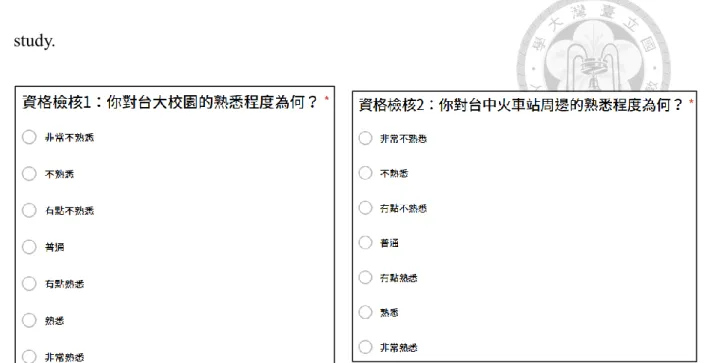
Convenience sampling was adopted in this study. From previous wayfinding studies (Fenner et al., 2000; Liben et al., 2013; Meilinger & Knauff, 2008), a number of 45 participants was decided in our study. Our participants were recruited from internet bulletin board, with the restrictions that participants must be unfamiliar with the real- world (NTU campus) or street view (Taichung Rail Station) wayfinding study sites.
Unfamiliarity was ensured by a screening test of subject recruitment (Figure 3). Those whose response was “very unfamiliar” or “unfamiliar” were admitted to participate in this
doi:10.6342/NTU201704041
29
study.
Figure 3 Screening test for participants recruitment
There were 15 participants for each cue type. Block randomization was use in assigning participants to each cue type, i.e. the first 3 participants recruited were randomly assigned to each cue type, followed by next 3 ones randomly assigned, etc.
The age range of our participants was between 21 and 44 (Mean (M) = 28, standard deviation (SD) = 6). The total number of male is 19. All participants have the education level of college or above. They were paid NTD 250 for an approximately 90 mins experiment session.
doi:10.6342/NTU201704041
30
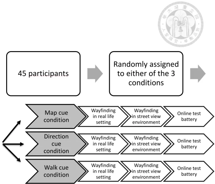
3.3 Design and materials
From section “3.1 Research design”, the design of this study followed a two-factor mixed experimental design and a survey method (Figure 4). The between-subject variable was wayfinding route cue types and the within-subject variable was wayfinding testing environment. Wayfinding route cue types were varied across 3 different groups of participants. Each participant received 2 different wayfinding testing environments, i.e.
real-world environment and Google Street View. The sequence of wayfinding testing environment was fixed. The real-world setting always came before Google Street View setting. The reason why the sequence of wayfinding testing environments were not counterbalanced was that participants were interviewed by the experimenter for the strategies adopted right after wayfinding test in either environmental setting. To attain naïve participants in real-world setting and to avoid carryover effect from Google Street View setting, wayfinding in real-world setting always preceded that in GSV setting.
All groups of participants underwent 3 experimental phases. The first phase was wayfinding testing in the real-world environment. The second phase was wayfinding testing in Google Street View interface. The last phase was an online test battery, which consisting of wayfinding strategy test, psychological abilities and geographical skills tests (see Table 1 for material used in each phases)
doi:10.6342/NTU201704041
31
45 participants
Randomly assigned to either of the 3
conditions
Map cue condition
Wayfinding in real life
setting
Wayfinding in street view
environment
Online test battery
Direction cue condition
Wayfinding in real life
setting
Wayfinding in street view
environment
Online test battery
Walk cue condition
Wayfinding in real life
setting
Wayfinding in street view
environment
Online test battery
Figure 4 Schematic diagram of a two-factor mixed experiment design.
The between-subject variable is wayfinding cue types and the within-subject variable is wayfinding testing environment.
doi:10.6342/NTU201704041
32
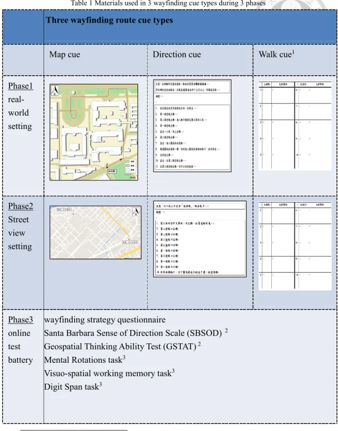
Table 1 Materials used in 3 wayfinding cue types during 3 phases
Three wayfinding route cue types
Map cue Direction cue Walk cue1
Phase1 real- world setting
Phase2 Street view setting
Phase3 online test battery
wayfinding strategy questionnaire
Santa Barbara Sense of Direction Scale (SBSOD) 2 Geospatial Thinking Ability Test (GSTAT) 2
Mental Rotations task3
Visuo-spatial working memory task3 Digit Span task3
1 In walk cue, participants were accompanied walking through the wayfinding route. A record sheet was given for them to take notes of any information helpful for later navigation on their own.
2 geospatial skills test
3 psychological abilities tasks
doi:10.6342/NTU201704041
33
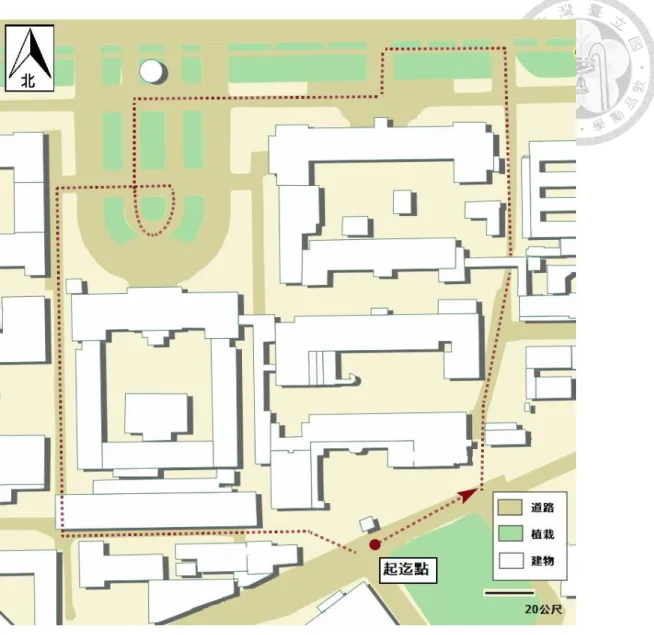
3.3.1 First phase: Wayfinding testing in real-world environment
In the real-world wayfinding testing phase, the wayfinding route was 830 m, taking about 10 min to complete at a moderate pace. The participants in map-cue condition received a partial map of National Taiwan University (NTU) campus, which was clipped from the NTU official electronical map (http://map.ntu.edu.tw/mobile.html#mappage).
The clipped map was modified to take out the names of all landmarks and only to include the north arrow, the scale bar, and the legend. The wayfinding route was indicated by red dotted line (Figure 5).
The route included 6 left turns, 2 right turns and an oval-shaped curve path. The road pavement was made of asphalt or tiles and no road signs along the route, which differed from regular traffic road networks. Participants were informed in advance about the definition of road network.
doi:10.6342/NTU201704041
34
Figure 5 Partial NTU campus map that participants in map-cue condition receive
doi:10.6342/NTU201704041
35
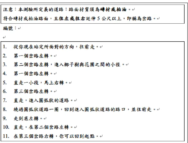
The participants in the direction-cue condition were given a list of 11 verbal directions from the starting point to the destination. To make a parallel with the map cue, direction cues were written in the skeletal description (Denis, 1997). The information of making turns at a specific road junction was provided while the names of landmarks were omitted. And to clarify the wayfinding route, a written definition of road and junction was noted (Figure 6).
Figure 6 List of direction instruction in the direction-cue condition
doi:10.6342/NTU201704041
36
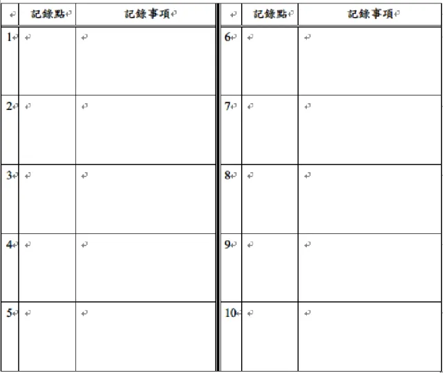
The third wayfinding route cue condition was walk cue. Participants in this condition were accompanied walking by the experimenter. Before walking, participants were given a record sheet to freely take notes of information that would help them travel the route by themselves in a reverse direction. The record sheet was made of a table with 10 cells to note the points of interest and related information. Participants were explicitly told that they could use the record sheet at will and points of interest were not limited to only 10 (Figure 7).
Figure 7 The record sheet provided in the walk cue condition.
doi:10.6342/NTU201704041
37
3.3.2 Second phase: Wayfinding testing in Google Street View
After finishing the wayfinding test in NTU campus, participants took wayfinding test on Google Street View interface, which was displayed on a 22-inch computer screen with Chrome browser. Participants were instructed to be seated upright so that the distance between eyes and screen kept at about 60 cm. A video clip of 1 min 38sec was played to introduce the interface of the GSV and show the participants how to navigate on GSV by keyboard. The navigation skills included moving forward or backward, rotating the viewing direction, zooming to see the streetscapes, and making turns (Figure 8).
Figure 8 Sample screen image of the Google Street View introduction video clip.
This frame showed the participants how to make to right turn.
doi:10.6342/NTU201704041
38
Participants had one minute to practice the navigation skills on Google street view interface. Taking advantage of the Google Street View API, street view displayed was modified to remove the road name watermarks and mini navigational map (Figure 9).
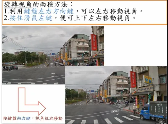
What’s more important, the navigational tracks of each participant were recorded by point with a time and location stamp. With the tracks and it stamps, it was plausible to execute a comprehensive analysis of the navigation behavior of each participant, which might bring a great potential of later wayfinding analysis.
Figure 9 Sample screen image of Google Street View.
Note that road names and mini navigational map are taken out.
doi:10.6342/NTU201704041
39
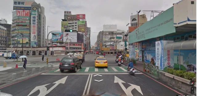
In the map-cue group, a map was clipped form Google map but under modification of removing road names, landmarks, and small alleys. North arrow and scale were preserved. In the second phase, the wayfinding route was on regular traffic network. The starting point (Tai-Chung Rail Station) and destination (Tai-Chung Hospital) were marked and wayfinding route was indicated by red dotted line (Figure 10). The reason why Tai-Chung was picked up was that the road network near Tai-Chung rail station was of the grid pattern and Tai-Chung was far away from Taipei, where participants were recruited. Participants were told that at the beginning of the task they would be located facing the Tai-Chung Rail Station. The route was about 1800m in length and included 6 left turns and 4 right turns, which were about the same number of turns as that in the first phase.
Figure 10 Wayfinding route map in map-cue condition
doi:10.6342/NTU201704041
40
In the direction-cue condition, a list of 10 verbal directions was given in the skeletal description form. Participants were instructed to ignore the small alleys in the Google Street View and concentrate on large streets and roads ( Figure 11).
Figure 11 List of direction instruction in the direction-cue condition
In the walk-cue condition, participants watched a five-minute video clip that showed the navigation process from the starting point to the destination. This video clip was at a slower than normal pace in order to give participants more time to process the information in the clip ( https://youtu.be/zo_cISLAxq4 ). Record sheet was given for participants to take notes of useful information to help them to navigate later on their own, while note- taking was not a compulsory action.
doi:10.6342/NTU201704041
41
3.3.3 Third phase: online test battery
In the third phase, a test battery consisted of a wayfinding strategy questionnaire, 3 psychological tasks, 2 geospatial ability scales, and a demographic survey was administrated online.
(1) Wayfinding Strategy Questionnaire
Wayfinding Strategy Questionnaire is an online 5-point Likert scale questionnaire developed by Lawton and Kallai (2002) (Figure 12). The questionnaire measures 2 different wayfinding strategies, the route strategy and the orientation strategy. When wayfinders rely on the landmark-based route information during wayfinding, the route strategy is preferred. When wayfinders are reported that they orient to global reference point (e.g. cardinal directions or North), the orientation strategy is preferred.
The questionnaire was translated into Chinese and contained 17 items. The first 11 items measured orientation strategy and remaining 6 items measured route strategy (see Appendix A for full questionnaire). Summation across belonging items was the score for each strategy. An extra item was added by the experimenter to investigate the way of commute.
doi:10.6342/NTU201704041
42
Figure 12 sample screen image of the questionnaire of wayfinding strategies
The following 3 psychological tasks were administrated online at http://www.cambridgebrainsciences.com/. This site was given its name after a team of neuroscientists at Cambridge University, UK. It offered a platform of 12 flash type online games which aimed to assess the neurocognitive functions such as reasoning, memory,
and planning. All 12 flash-game task were accessible to the public, while some tasks required signing in in the first place.
doi:10.6342/NTU201704041
43
(2) Rotations task
Two boxes appeared on the screen with green and red squares filled in. Within 1 min 30 sec, participants were required to make a judgment of whether the two panels would be identical once mentally rotate either one panel (Figure 13). Item scores were given per each judgement.
Figure 13 Sample screen image of rotations task
Item scores were given according to the number of squares in the box. When correct responses were made, participants gained the point, otherwise lose it. If two successive correct responses were made, number of squares would increase by one. Mental rotation abilities were linked to performance in perspective taking and navigation. In particular, mental rotation skills have been found to significantly correlate with route learning;
Individuals who performed better at mental rotation tasks were more able to find the most direct route out of a wooded terrain (Silverman et al., 2000).
doi:10.6342/NTU201704041
44
(3) Monkey Ladder task (visuo-spatial working memory, VSWM)
Boxes would appear at different locations on the screen, each having a number.
Participants had to remember the numbers on each box. After a short period of time, the number would disappear. Participants were required to click on the boxes in numerical sequence (Figure 14). If correct responses were made, participants would have one more box to remember, otherwise one less box. After 3 errors were made, the test end. The test scores were the number of boxes at the last correct trial. Inoue and Matsuzawa (2007) found that a well-trained chimpanzee could maintain as high as 9 boxes in spatial working memory. That’s exactly the reason why this task was called “Monkey ladder”. Their research suggested that spatial working memory might play an essential role in human spatial cognition.
Figure 14 Sample screen image of monkey ladder task
doi:10.6342/NTU201704041
45
(4) Digit Span task
Participants were instructed to remember the digit sequence that successively appeared at the center of the screen. The flash rate of the digit was 500ms per each digit.
After all the digits had shown up, participants were required to press the number pad on the keyboard in the same sequence of the appearance of the digits. If correct responses were made, participants would have one more digit to remember, otherwise one less digit.
Possible maximum task scores were 25. After 3 errors were made, the test end. The test scores were the number of digits at the last correct trial. Digit span was associated with verbal information storage. In the working memory model (Baddeley & Hitch, 1974), digit span revealed the verbal working memory abilities, which allowed temporary verbal information storage and manipulation.
Figure 15 Sample screen image of digit span task