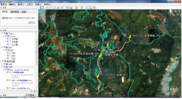
應用公眾參與地理資訊系統於社區發展生態旅遊之研究(3/3)
全文
數據


相關文件
which can be used (i) to test specific assumptions about the distribution of speed and accuracy in a population of test takers and (ii) to iteratively build a structural
This kind of algorithm has also been a powerful tool for solving many other optimization problems, including symmetric cone complementarity problems [15, 16, 20–22], symmetric
Contribute to the global LMS community and inform about the challenges and opportunities for executing computer- based assessment using the LMS platform in Hong Kong secondary
They are: Booklet (6) – Healthy Community, exploring the communicable and non- communicable diseases and how they affect community health so that students are able to
We hope to engage and collaborate with stakeholders in the community to explore the many possibilities of aging through creative workshops and community engagement3. We hope
The objective of the present paper is to develop a simulation model that effectively predicts the dynamic behaviors of a wind hydrogen system that comprises subsystems
The exploration of the research can be taken as a reference that how to dispose the resource when small and medium enterprise implement management information system.. The
The aim of this study is to develop and investigate the integration of the dynamic geometry software GeoGebra (GGB) into eleventh grade students’.. learning of geometric concepts
