國立臺灣大學生物資源暨農學院農業化學系 碩士論文
Department of Agricultural Chemistry College of Bioresources and Agriculture
National Taiwan University Master Thesis
探討臺灣代表性土壤利用世界土壤參比分類系統之 問題及其與美國土壤分類名稱之對應
The Problem of Using World Reference Base (WRB) Soil Classification System in Taiwan Representative Soils and
the Correlation between WRB and Soil Taxonomy
范惠茹 Huei-Ju Fan
指導教授:陳尊賢 博士 Advisor: Zueng-Sang Chen, PhD.
中華民國 101 年 6 月
June, 2012
謝誌
本篇論文得以完成,要感謝指導教授-陳尊賢 老師不遺餘力的指導,也要感 謝中興大學土壤環境科學系的黃政恆 教授、宜蘭大學森林暨自然資源學系的蔡呈 奇 教授、屏東科技大學環境工程與科學系的許正一 教授及水土保持學系的簡士 濠 教授等口試委員,對於本論文提供寶貴的意見及許多觀念的導正,由衷感謝各 位老師的幫助。
在土調研究室攻讀碩士的這二年,在知識及思考上都成長許多,但也越顯得 自己懂得太少、做得也太少,有必要在實際事務上好好磨練。要感謝的人好多,
第一位要感謝的就是我的恩師 陳尊賢 教授,老師對我的教誨與啟發實在太深太 廣,從每一天最早到實驗室工作、甚至最晚離開實驗室的真實身教,到對學生孜 孜不倦、諄諄教誨的許多言教:「不要作有錢的人,要做一個大家都尊敬你的人﹗」
「我們擁有那麼多的資源,要心存感激,要貢獻自己於這個社會!」「要常常幫助 別人,別人才會願意幫你,離開實驗室前問自己兩個問題:今天有沒有學到什麼?
今天有沒有幫到人?」…等,惠茹尤其感到慚愧,常常讓陳老師一再叮囑、點醒自 己的缺失。
對於研究,惠茹曾經在藍海及紅海的領域中徬徨不知如何選擇,感謝陳老師 的支持讓我得以繼續我喜愛的基礎研究-土壤分類,讓我可以貪心的面對巨觀的 現象,而非侷限於微觀探討,去思考土壤於整個環境下會是什麼樣子的,從氣候、
母岩、植被、流動在上面的河川及底下的地下水,乃至農業耕作的影響來著墨。
在臺大兩年的生活中除了宿舍,隱身在農場中的土壤調查與整治研究室(又 稱洋菇館)就像是第二個家,研究室的大家:阿志學姐、家興學長、正介學長、
紹偉學長、小燕、淑鑫、家綺、鄉娜、喬宜、大花、顥嚴、泰祥、依庭、宏毅,
及已經回福建的青青,感謝你們一直以來的照顧與幫助,一同採樣、出遊及吃吃 喝喝是研究生活中難得的調劑。喜愛排球運動的我來到農化系並不孤單,與農化 生技女排隊友一起征戰大小沙場,得到生平第一座冠軍是我最最難忘的經典回 憶。感謝摯友梅桂與淑憓總是包容我、陪我一起歡笑、一起流淚,以及一同放膽 追逐人生的興趣及夢想。另外,也要特別感謝農試所農化組-陳柱中學長的協助,
提供臺灣新調查樣點的資料作為我論文的參考。
最後,一定要感謝的是我的家人,老爸、老媽、媛姐、婷姐及珺珺始終給予 我滿滿的愛與無怨無悔的支持,感謝老天賜與我許多,希望我能珍惜福分並努力 對社會及國家做出貢獻。
I
探討臺灣代表性土壤利用世界土壤參比分類系統之 問題及其與美國土壤分類名稱之對應
范惠茹
摘要
臺灣土壤調查過去皆以美國土壤分類系統 (Soil Taxonomy, ST) 當作土壤分類 系統,其中Entisols (新成土)、Inceptisols (弱育土)、Alfisols (淋餘土) 及 Ultisols (極 育土) 占前四大主要土壤分佈類別。世界土壤參比分類系統 (World Reference Base for Soil Resources, WRB) 為 十 年 來 由 聯 合 國 糧 農 組 織 土 壤 分 類 系 統 (FAO-UNESCO system) 修改的國際土壤分類系統,近五年已於歐亞非三洲盛行,
往往被當作全球化下各國土壤資訊轉換的橋樑,可補足ST 土壤分類系統的相關缺 憾。本論文將選出臺灣面積大於1,000 公頃或具有特殊性的土壤作為此研究之臺灣 代表性土壤,將這些土壤利用 WRB 分類系統分類後討論套用 WRB 時產生的問 題,並利用WRB (2006 版本) 及 Gray et al. (2011) 得到 ST 及 WRB 系統的標準對 應表,而對應度 (similarity) 即表示為可正確對應的土壤數除上總土壤數。
本研究選出的 172 個代表性土系之平均對應度為 64%,討論造成對應度低的 原因,首先是水成土壤,由於WRB 系統十分重視水的作用而較 ST 新增了許多水 成土壤的高階土壤分類單位及診斷特性,在臺灣常被討論的水成土壤,包含地下 水造成的Gleysols (灰白土)、Plinthosols (鐵網紋土)、表面浸水一段時間的 Stagnosols (淹水土),診斷特徵如 Gleyic colour pattern (灰白色彩型態)、Plinthic horizon (鐵網 紋層) 及 Stagnic colour pattern (淹水色彩型態)。WRB 新增特徵除了造成兩大系統 下分類出的水成土壤結果不一致外,實際上在土壤分類時,常造成同一特徵由於 同時符合診斷特徵而重複判斷。另外,人為灌水產生的淹水土由於也具有 Stagnic colour pattern 而可能遭誤解被分類為 Stagnosols。
II
Cambisols (變育土) 對應度低是因為 WRB 系統明顯比 ST 系統能有效描述人 為耕作的因子,因此有許多ST 系統新成土在 WRB 系統下可符合人為耕作層而進 一步分類成變育土,例如Anthraquic horizon (水田耕作層)、Hydragric horizon (人為 浸水層) 及 Irragric horizon (灌溉沉積層)。其他與對應度無關,但在臺灣土壤往往 會發生的特殊情況有:有大比例的臺灣水田土壤由於無法符合 Anthrquic horizon 對土色的要求,而錯失正確分類的機會。部分風化時間悠久的臺灣紅土即使土壤 剖面中黏粒含量分佈均勻,但CEC 仍不符合 < 16 cmolc/kg clay 的標準而無法分類 為Ferralic horizon (鐵鋁層)。具可觀數量的臺灣新沖積土往往因為土層厚度太薄而 無法符合WRB 系統的 Fluvic material (沖積診斷特性),而無法被分類為沖積土,
僅能分類為Regosols (腐石土)。Leptosols (薄層土) 在 WRB 系統中沒有明顯定義為 當地母岩化育而成,容易被沖積或崩積土壤混淆而誤分類為此參考土類。WRB 系 統的Arenosols (砂質土) 僅提及沙漠或海灘的砂土,沒有將臺灣常見沖積及崩積砂 質土包含在內,容易造成讀者對於砂質土分類的誤解。
關鍵字:世界土壤參比分類系統 (WRB),美國土壤分類系統 (ST),臺灣代表性土 壤,土壤分類,參考土類,和諧化,土壤分類系統對應度。
III
The Problem of Using World Reference Base (WRB) Soil Classification System in Taiwan Representative
Soils and the Correlation between WRB and Soil Taxonomy
Huei- Ju Fan
Abstract
620 rural soil series were developed in the history of soil survey projects from 1962 to 1979 in Taiwan. These soil series have been classified by the USDA Soil Taxonomy system (ST) and the major Soil Order were Entisols, Inceptisols, Alfisols and Ultisols. In last decade, World Reference Base for Soil Resources (WRB) system was revised from the FAO-UNESCO soil classification system and was significantly used by many countries in Europe, Asia and Africa regions. WRB system can be regarded as the system to compensate the weakness of USDA Soil Taxonomy system. A correlation table were developed to assess the correlation of soil taxa of this study based on the standard correlation tables by using the published paper of Gray et al. (2011).
In this study, we selected 172 representative soil series from Taiwan to discuss the problems for Taiwan soil series to be classified by the WRB system. The study showed the mean similarity of correlation was 64% which was produced mainly by the Hydric soils including Plinthosols, Gleysols and Stagnosols in the WRB system. The relative lower similarity of correlation table was produced by various soil formation factors and soil characteristics. WRB system has created more Hydric diagnostic properties and horizons than ST system, including plinthic horizon, gleyic colour pattern and stagnic colour pattern. The other main errors of high category are also produced by the hydraulic soil characteristics, including Gleysols, Plinthosols, Planosols, and Stagnosols.
Although these differences can be identified by the pedogenetic processes of the magor soil groups, it make the soil surveyors easily confuse to identify and describe the soil properties and soil formation. Also, A lot of Flooding soils irrigated with water also have stagnic colour pattern, and it can be misunderstood and to be classified into Stagnosols.
IV
WRB system created anthropogenic factors to affectly describe the soil formation process by human cultivation which are listed as criteria of Anthrosols, Cambisols and others, and the Entisols in ST with the cultivation evidence can be classified as Cambisols. There are some unique and important problems happened by using WRB systems to classify Taiwan soils. Many Paddy soils of Taiwan can be classified as uncorrected soil group which lack of the criteria of anthraquic horizon. Some red soils with long-term weathering soils even have uniform distribution of clay particle and without argic horizon, but it still can not meet the criteria of CEC value ( < 16 cmolc/kg clay) and can not be classified as Ferralic horizon. Taiwan alluvial soils are too thin to meet the evidences of stratification of fluvic material, and it was classified as Regosols, not to be Fluvisols. The formation of Leptosols can not be identified to be developed in-situ weathering of sediments or rocks, therefore the alluvial and colluvic soils can be misunderstood and to be classified as Leptosols. Arenosols are defined as the soils formed from sandy soils appearing in the beach and desert, but it was not included the sandy soils with fluvic soils and colluvial soils in Taiwan.
Key words:World Reference Base for Soil Resources, USDA Soil Taxonomy, Taiwan
representative soil, Soil classification system, Reference soil group, Harmonization, similarity of correlation table.V
目錄
頁碼
中文摘要………...I 英文摘要……….III 目錄………,….V 圖目錄………...………….VII 表目錄………..………....VIII第1 章 前言 ... 1
第2 章 文獻回顧 ... 3
2.1 世界土壤參比分類系統 (WRB) 簡介 ... 3
2.1.1 世界土壤參比系統 (WRB) 的歷史 ... 3
2.1.2 世界土壤參比系統 (WRB) 的基本規則 ... 4
2.1.3 世界土壤參比系統 (WRB) 的內容 ... 5
2.1.4 WRB 的架構 ... 8
2.2 WRB 的價值及應用 ... 10
第3 章 材料與方法 ... 12
3.1 臺灣各縣市代表性土壤的選定標準 ... 12
3.2 臺灣各縣市代表性土壤的分類 ... 13
3.2.1 臺灣土壤利用WRB 進行分類 ... 13
3.2.2 分類的經驗法則 ... 14
3.3 WRB 與 ST 的對應 ... 31
第4 章 結果與討論 ... 33
4.1 臺灣各縣市農地具代表性土系 ... 33
4.2 臺灣各縣市代表性土壤的分類及整理 ... 33
4.2.1 臺北地區土壤的分類及討論 ... 33
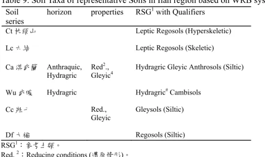
4.2.2 宜蘭地區土壤的分類及討論 ... 43
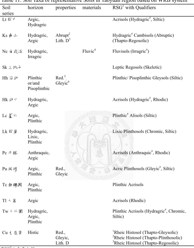
4.2.3 桃園地區土壤的分類及討論 ... 49
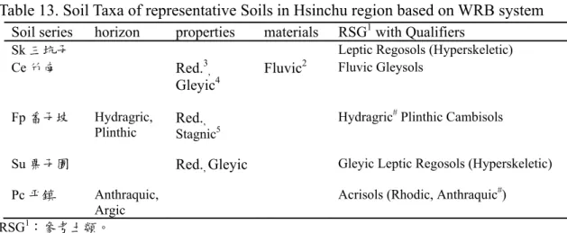
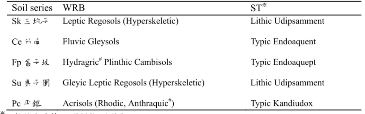
4.2.4 新竹地區土壤的分類及討論 ... 59
4.2.5 苗栗地區土壤的分類及討論 ... 63
4.2.6 臺中、南投地區土壤的分類及討論 ... 68
4.2.7 彰化地區土壤的分類及討論 ... 79
4.2.8 雲林地區土壤的分類及討論 ... 94
4.2.9 嘉義地區土壤的分類及討論 ... 108
4.2.10 臺南地區土壤的分類及討論 ... 120
4.2.11 高雄地區土壤的分類及討論 ... 132
4.2.12 屏東地區土壤的分類及討論 ... 138
VI
4.2.13 花蓮地區土壤的分類及討論 ... 146
4.2.14 臺東地區土壤的分類及討論 ... 152
4.3 WRB 與 ST 對應度及對應問題 ... 155
第5 章 結論 ... 159
第6 章 參考文獻 ... 160
VII
圖目錄
圖 1、簡易參考土類索引……….15
VIII
表目錄
表1、32 個參考土類的釋義 ... 6
表2、字首修飾詞 (Prefix qualifiers) 及字尾修飾詞 (Suffix qualifiers) ... 9
表3、pH 相對應之鹽基飽和度 ... 19
表4、質地所相對應之陽離子交換能力 (CEC) ... 21
表5、ST 與 WRB 標準對應關係 ... 32
表6、挑選出臺灣的農地代表性土壤 ... 34
表7、臺北地區代表性農地土壤利用 WRB 的分類名稱 ... 39
表8、臺北地區土壤的 WRB 及 ST 分類結果之對應 ... 42
表9、宜蘭地區代表性農地土壤利用 WRB 的分類名稱 ... 44
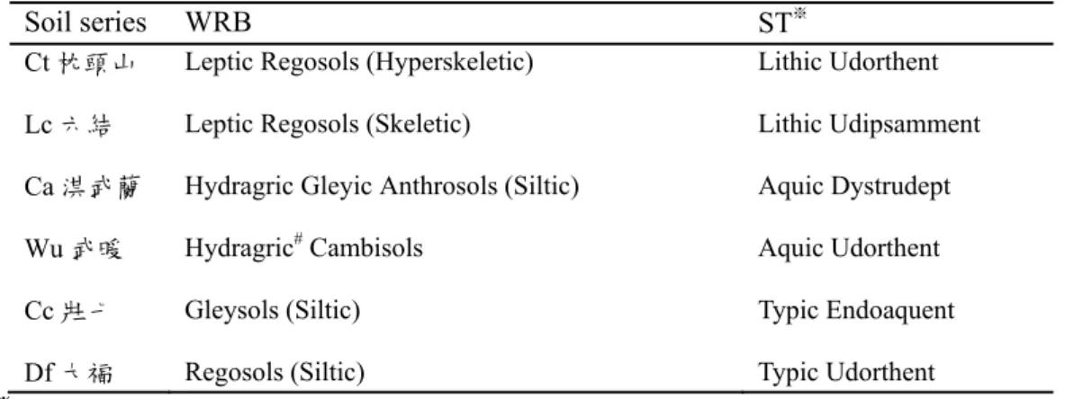
表10、宜蘭地區土壤的 WRB 及 ST 分類結果之對應 ... 48
表11、桃園地區代表性農地土壤利用 WRB 的分類名稱 ... 51
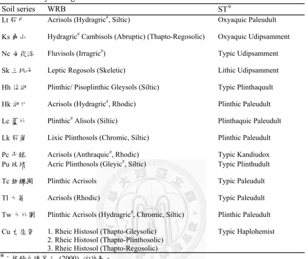
表12、桃園地區土壤的 WRB 及 ST 分類結果之對應 ... 58
表13、新竹地區代表性農地土壤利用 WRB 的分類名稱 ... 60
表14、新竹地區土壤的 WRB 及 ST 分類結果之對應 ... 62
表15、苗栗地區代表性農地土壤利用 WRB 的分類名稱 ... 64
表16、苗栗地區土壤的 WRB 及 ST 分類結果之對應 ... 67
表17、臺中南投地區代表性農地土壤利用 WRB 的分類名稱 ... 69
表18、臺中南投地區土壤的 WRB 及 ST 分類結果之對應 ... 78
表19、彰化地區代表性農地土壤利用 WRB 的分類名稱 ... 80
表20、彰化地區土壤的 WRB 及 ST 分類結果之對應 ... 93
表21、雲林地區代表性農地土壤利用 WRB 的分類名稱 ... 95
表22、雲林地區土壤的 WRB 及 ST 分類結果之對應 ... 107
表23、嘉義地區代表性農地土壤利用 WRB 的分類名稱 ... 109
表24、嘉義地區土壤的 WRB 及 ST 分類結果之對應 ... 119
表25、臺南地區代表性農地土壤利用 WRB 的分類名稱 ... 121
表26、臺南地區土壤的 WRB 及 ST 分類結果之對應 ... 131
表27、高雄地區代表性農地土壤利用 WRB 的分類名稱 ... 134
表28、高雄地區土壤的 WRB 及 ST 分類結果之對應 ... 137
表29、屏東地區代表性農地土壤利用 WRB 的分類名稱 ... 140
表30、屏東地區土壤的 WRB 及 ST 分類結果之對應 ... 145
表31、花蓮地區代表性農地土壤利用 WRB 的分類名稱 ... 148
表32、花蓮地區土壤的 WRB 及 ST 分類結果之對應 ... 151
表33、臺東地區代表性農地土壤利用 WRB 的分類名稱 ... 153
表34、臺東地區土壤的 WRB 及 ST 分類結果之對應 ... 154
表35、臺灣代表性土壤在 WRB 和 ST 的對應度 ... 157
1
第1章 前言
臺灣各縣市農地土壤調查報告書在 1962-1979 年間陸續完成,共建立了 620 個農地土系,當時使用的土壤分類系統是1949 年美國農業部發行的舊美國土壤分 類系統進行分類。由於舊分類系統較粗放及簡略,大多僅以土壤母質或剖面顏色 以及其他特性命名,遂美國農業部於1975 年建立新的美國土壤分類系統 (ST),由 六個分類綱目組成,可將土壤較仔細及準確的描述,正是目前學術界通用的世界 分類系統之一。因此蔡呈奇等人 (1998) 以及陳尊賢等人 (2000) 陸續將臺灣各土 系改以新美國土壤分類系統 (Soil Survery Staff, 1999) 重新分類及統整。
儘管新美國土壤分類系統發展已趨成熟,但仍屬單一國家所發行的土壤分類 系統,與其他發展悠久的國家分類系統 (俄羅斯邦聯、德國、日本、法國、澳洲、
加拿大…等) 一樣,無法作為全世界通用的土壤分類官方語言。另外,糧食問題以 及地球上資源漸趨缺乏的情形下,國與國之間的互相依賴及資訊交流漸盛,更突 顯出缺乏統一性國際土壤語言的問題,因此,世界土壤參比系統 (WRB) 的概念 就在聯合國農糧組織 (FAO) 及各國土壤學家推動下漸趨形成。
WRB 是一種國際間通用的土壤分類系統,由 IUSS (International Union of Soil Sciences) 和聯合國糧農組織 (FAO) 贊助發行,並且由 ISRIC (International Soil Reference and Information Centre) 參與內容的研究及修正。可提供國與國之間交換 土壤資訊時,有統一且簡易的土壤科學語言可以利用,目前已成為歐盟及中西非 土壤科學的官方土壤分類系統。除了作為土壤科學的共通語言外,WRB 集各國土 壤分類系統於大成,除收錄各系統的診斷內容外,也增加當地土壤特色及土地利 用情形,讓使用者能夠簡易利用此套系統,編撰地理資訊系統及擬定土壤管理政 策,卻又不造成使用上出現國界的藩籬。
2
臺灣人口及占地雖小,但在亞洲地區的農業土壤科學以及環境科學擁有許多重 大的研究成果,不論在科學研究文章之發表或是先進技術之互享的立場,都應該 有國際性的土壤科學語言在國內流通,以增加能見度及便利性。臺灣地區近年來 主要偏向使用美國土壤分類系統,目前國內尚未有學者利用WRB 將臺灣地區的土 壤進行分類的報告,就全球資訊和諧化的角度來看,臺灣在WRB 系統方面之資訊 較為不足,恐導致無法與世界系統 (歐洲各國) 聯繫;就科學進步角度來看,臺灣 擁有優異的地理、氣候及地質條件,從低海拔到高海拔地區的土壤,土壤豐富的 多樣性從新美國土壤分類系統12 種土綱便出現 11 項便可知悉,定能提供 WRB 分 類系統改進之建議,並讓臺灣土壤資訊成為世界土壤資訊之一員。另外,許多國 家 (Zádorová and Penížek, 2011; Mojiri et al. 2011; Shi et al., 2010) 紛紛利用各自國 家或原使用的分類系統,與國際分類系統的WRB 作對應關係,除了可以利用對應 度高低得知分類的可信程度,更重要的意義是此表可以作為未來國際間土壤語言 交換時,將土壤分類單位轉換的橋梁。
因此本研究目的是將臺灣土壤利用WRB 系統加以分類,來提供臺灣土壤使用 WRB 分類系統所遭遇之問題,並且將 WRB 分類結果與原先美國系統的分類結果 做對應分析與比較。
3
第2章 文獻回顧
2.1 世界土壤參比分類系統 (WRB) 簡介
2.1.1 世界土壤參比系統 (WRB) 的歷史
1980 年代早期,國際間農產品與食物的供給開始互相依賴,土地退化的問題、
以及土地的生產潛力和餵養人口能力之差異,成為國際間最在意的問題之一,也 因此土壤資訊的統一被認為首要之務。在此種情勢下,聯合國農糧組織 (FAO) 認 為應該存有一個土壤分類系統作為聯繫以及統一的語言,同時也能提供國際間溝 通及交流經驗的方式。在FAO 的倡議下,聯合國教科文組織 (UNESCO)、聯合國 環境署 (UNEP) 及國際土壤科學協會 (時為 ISSS,後來更名為 IUSS) 的各領域土 壤科學家,在1980 及 1981 年召開會議,會中除發行 1:5,000,000 的世界土壤地圖 (FAO-UNESCO, 1971-1981),更決議研究出一套「國際土壤參比分類」(IRB, International Reference Base for Soil Classfication),並且擬定其規模必須讓全世界的 土壤都能夠定義及分組,並且開宗明義地說明其功能:交換土壤資訊、提供簡易 的科學語言、加強土壤科學的應用,以及與土壤先進國家增加溝通。
1992 年,IRB 工作小組將訂正後的世界土壤地圖圖例 (FAO-UNESCO-ISRIC, 1988) 作為 IRB 日後的研究基礎,並同時將 IRB 更名為 WRB (World Reference Base for Soil Resources),在本論文中譯作「世界土壤參比分類系統」。
經過多年不斷的會議討論和測試,以及在世界各地進行實地考察 (包括比利時 魯汶、德國基爾、俄羅斯莫斯科、南非、阿根廷及奧地利維也納),終於在 1998 年出版了WRB 的第一本教科書,內容包含:世界土壤參比分類系統之簡介、世界 土壤參比分類系統之圖例及世界土壤參比分類系統正文。這本教科書也被ISSS 接 受並且推薦使用於官方文章中的分類及命名術語。在全體共識下,決議不改變內 容至少八年,以接受廣泛的測試。一直到 2006 年第 18 屆世界土壤科學會議才提
4
出修改。在第一版出版的期間 (1998-2006 年),WRB 成為了歐盟及中、西非土壤 科學協會的土壤命名及分類的官方系統、被義大利、墨西哥、挪威、波蘭和越南 列為較高等級的分類系統,並且翻譯成13 種語言 (中、法、德、荷、義、日、西、
俄、波蘭、越南、羅馬尼亞、立陶宛及拉脫維亞)。教科書內容更進一步以演講、
世界主要土壤的CD-ROM (FAO, 2001a and 2001b)、2002 年由 FAO 及 ISRIC 合作 出版的1:25,000,000 比例尺之世界土壤資源地圖來做範例說明。
2.1.2 世界土壤參比系統 (WRB) 的基本規則
WRB 是一個全方位的土壤分類系統,能夠容納各個國家發行的分類系統。
WRB 除當作世界各國分類系統的聯繫外,也作為編寫全球土壤資料庫及監測、發 現世界土壤資源的工具,其存在的目的並非是取代各國家本身的土壤分類系統,
而是希望可以提供一個簡易的命名方式於國際間交流使用,因此其命名單位的寬 度足以促進與其他原有的國家系統聯繫及統一。在WRB 較低階的分類等級中,其 尺度大概是一個國家大小的區域密度,同時也會強調出種種影響土地使用管理的 相關土壤特徵。另外,WRB 土壤命名系統作為一個通用的系統,具有準確的土類 名詞及定義,以避免過去的傳統舊名詞與現代的新創詞彙衝突,出現同一名詞有 不同意義的情形而混淆。
WRB 的基礎在於將 1980 年發行的 FAO-UNESCO 世界土壤地圖加以修正後的 版本,使用者可方便直接連結到已建立好在地圖上的國際土壤。WRB 土壤單位的 定義及描述可反映出土壤垂直及水平的特性,如此便可將地景 (land scape) 整個連 結起來。WRB 分類土壤時,必須利用那些含量最大、可直接被觀察或是測量出的 診斷層 (diagnostic horizons)、特性 (properties) 及物質 (materials) 的名詞來定義土 壤性質。挑選診斷特性時,盡量地將土壤形成過程也考慮進去,因為了解土壤形成 過程可以較完善地描述土壤;並且最好選擇高等級、具概括性及對土壤管理有明顯 影響的診斷特徵。值得注意的是,許多參考土類在不同的氣候下都會生成,因此
5
WRB 不把氣候納入分類的內容裡,換句話說,世界土壤參比系統在分類土壤時並 不受任何氣候資訊控制,因為 WRB 小組認為氣候與土壤特性的動態因果關係,並 不構成定義土壤的任何部分。根據Gray et al. (2011) 探討五大成土因子與 WRB 參 考土類的關係,發現部分參考土類與預期不同,的確在不同雨量區的氣候下都會出 現。雖然在 WRB 土壤單位裡看不到美國土壤分類的溫度境況 (Soil Temperature Regime in the family-level) 或是水分境況 (Soil Moisture Regime),但 WRB 並不會忽 略氣候造成的特徵的描寫,例如水成土壤的特徵在 WRB 敘述極多,而有許多水成 土壤的成因正是因為是多濕的氣候。
在WRB 比較高級的分類項目裡,除非此土壤有特別重要的土壤母岩物質,否 則,主要是依照初步成土過程對土壤造成的「初級風化特徵」來區分階級。而在較 次級的分類項目中,土壤單位則根據那些會明顯改變初級土壤特徵的「次級土壤風 化過程」來區分,但在某些土壤的情況中,也必須考慮明顯受到土地使用方式影響 而發生的土壤特徵。
2.1.3 世界土壤參比系統 (WRB) 的內容
WRB 分類系統僅有兩個階級,其分類詞彙是由具「參考土類」(the RSGs),
加上一組獨特意義 (包含字首詞與字尾詞) 的「修飾詞」(qualifiers) 組合而成的 詞,這樣的詞彙組合能夠給予土壤更精準的描述以及將單一、獨特的土壤剖面加 以分類。
首先,參考土類屬於最高階級,目前已有32 個參考土類 (WRB, 2006),代表 著許多不同的主要土壤區域,欲囊括全世界的所有土壤,其概念來自世界土壤地 圖圖例的單位 (FAO-UNESCO, 1971-1981; FAO-UNESCO-ISRIC, 1988)。32 個參考 土類可分成10 種基本意義 (表 1)。
6
表1、32 個參考土類的釋義
Table 1. Rationalized Key to the WRB Reference Soil Groups
Type Reference soil groups (32 groups) Soils with thick organic layers Histosols
Soils with strong human influence Anthrosols, Technosols Soils with limited rooting due to shallow
permafrost or stoniness
Cryosols, Leptosols
Soils influenced by water Vertisols, Fluvisols, Solonetz, Solonchaks, Gleysols
Soils set by Fe/Al chemistry Andosols, Podozols, Plinthosols, Nitisols, Ferralsols
Soils with stagnating water Planosols, Stagnosols
Accumulation of organic matter, high base status Chernozems, Kastanozems, Phaeozems Accumulation of less soluble salts or non-saline
substances
Gypsisols, Durisols, Calcisols
Soils with a clay-enriched subsoil Albeluvic tonguing
Albeluvisols, Alisols, Acrisols, Luvisols, Lixisols
Relatively young soils or soils with little or no profile development
Umbrisols, Arenosols, Cambisols, Regosols
7
32 個土類分別為 Histosols (有機土)、Anthrosols (人為土)、Techosols (科技土)、
Cryosols (冰凍土)、Leptosols (薄層土)、Vertisols (膨轉土)、Fluvisols (沖積土)、
Solonetz (鹼土)、Solonchak (鹽土)、Gleyosols (灰白土)、Andosols (灰燼土)、Podzols (暗色土)、Plinthosols (鐵網紋土)、Nitisols (黏亮土)、Ferralsols (鐵鋁土)、Planosls (黏 盤土)、Stagnosols (淹水土)、Chernozems (黑鈣土)、Kastanozems (棕鈣土)、Phaeozems (灰鈣土)、Gypsisols (石膏土)、Durisols (硬盤土)、Calsisols (聚鈣土)、Albeluvisols (漂 白洗入土)、Alisols (高活性聚鋁土)、Acrisols (聚鋁土)、Luvisols (高活性淋餘土)、
Lixisols (淋餘土)、Umbrisols (黑瘠土)、Arenosols (砂質土)、Cambisols (變育土) 及 Regosols (腐石土)。
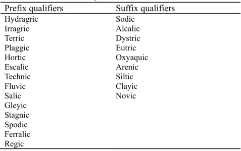
較次階級的參考土類修飾詞 (qualifiers) 為一組附於參考土類前或後的修飾 詞。每個修飾詞具有特殊定義,可更進一步描述參考土類的詳細土壤特性,但在 同一組分類詞彙中,不可同時出現兩個彼此意義相近或是相同的修飾詞。
參考土類修飾詞分兩種:
字首修飾詞 (Prefix qualifiers):置於參考土類之前,為典型及過渡型的修飾 詞 (典型:一個參考土類的典型特性;過渡型:參雜有其他參考土類的重要診斷特 性)。但有一個字首修飾詞’’Haplic ’’,為既非典型也非過渡型的字首修飾詞。利用 WRB 來設計小比例尺 (small-scale) 的世界土壤地景圖時,建議單位使用字首修飾 詞,繪圖尺度約在1:5,000,000 到 1:1,000,000 之間。在分類階級來看,字首修飾詞 先於字尾修飾詞。
字尾修飾詞 (Suffix qualifiers):置於參考土類之後並通常用括號框住,為其 他型的修飾詞 (其他型:並非一個參考土類的典型特性,且與其他參考土類不具相 關性),代表了以下特徵:土壤出現的診斷層、特性或物質,以及其他關於化學、
物理、礦物、表面、質地與顏色等的特徵。若要利用WRB 來設計大比例尺 (big-scale) 的地區土壤地景圖,繪圖尺度在1:6,000,000 到 1:25,000 之間時,建議使用字尾修 飾詞。
8
2.1.4 WRB 的架構
一組完整的分類詞彙 (含有參考土類及參考土類修飾詞),通常參考土類下會 列出所有可能出現的字首及字尾修飾詞,以 Anthrosols (人為土) 為例 (表 2)。以 接下來兩個範例說明可能會出現的詞彙情形,及其所代表的意義。
1. Hydragric Anthrosols (siltic)
由於耕作灌水而成的人為土;土層深度100 cm 內有 30 cm 以上土壤質地為坋土、坋
質壤土、坋質黏壤土或是坋質黏土。
2. Hydragric Fluvic Anthrosols (Eutric, clayic)
因為耕作灌水而成的人為土,人為耕作層之下立即顯現原本沖積土的堆疊層化證
據;土層深度20-100 cm 或是 20 cm 到母岩內,其主要土壤的鹽基飽和度大於 50%,
另外100 cm 內有 30 cm 以上土壤質地為黏土。
9
表2、字首修飾詞 (Prefix qualifiers) 及字尾修飾詞 (Suffix qualifiers)
-以Anthrosols 為例
Table 2. Prefix and suffix qualifiers in the WRB-case of Anthrosols Prefix qualifiers Suffix qualifiers
Hydragric Sodic Irragric Alcalic Terric Dystric Plaggic Eutric Hortic Oxyaquic Escalic Arenic Technic Siltic Fluvic Clayic Salic Novic Gleyic
Stagnic Spodic Ferralic Regic 註:字首與字尾排的順序無關聯
10
2.2 WRB 的價值及應用
WRB 作為世界共通土壤語言,能夠提供一簡易的平臺作為各國溝通的橋梁,
近年來許多環境及社會問題都正在跨越國界的發生,Sanchez et al. (2009) 曾提 到:「包含糧食安全、氣候變遷、環境遭破壞退化、水資源缺乏或是生物多樣性屢 遭破壞等,正需要全面性的政策及作法來預估或者解決,首先需要建立一套數位 解析度佳的世界土壤地圖,除了輸入土壤特性外,也可進一步提供土壤管理方式 或是土地利用情形。目前世界上109 個國家仍使用解析度低 (1:1,000,000 或更小比 例尺) 地圖,且這些地圖僅占地球 31% 的面積,尚有許多空間進步…」這些需求 都仰賴著更臻成熟的WRB 系統,因為具有通用及實用的特性,而能建構出世界通 用的土壤地圖及地理資訊系統,並且尺度能適用於各個領域使用,例如研究全球 養分循環的科學家僅需要1 km 的解析度資訊,國家規劃者需使用 90 m 解析度資 訊,農民則需要更佳的30 m 之解析度資訊。
目前已有許多聯盟及國家使用WRB 來繪製土壤圖,歐盟根據 WRB 的內容發 表了歐洲土壤圖,北極圈、拉丁美洲都已完成了 1:3,000,000 的土壤圖。各國也利 用 WRB 進行分類及相關探討,Shi et al. (2010) 將中國土壤發生分類 (GSCC, Genetic Soil Classification of China) 與 WRB 分類系統作了相互參比的討論,利用 中國第二次土壤調查所得到的7292 筆土壤資料作為國家尺度的背景資訊庫,並建 立了可有效評斷參比情形是否可信的對應度 (referencibility) 方法;另外,提出了 WRB 沒有將氣候列入診斷標準是造成部分中國土壤對應度低的原因之觀點。
Zádorová and Penížek (2011) 使用 1963-1967 年的舊捷克-斯洛伐克大尺度農業土壤 調查報告書,從中隨機選取433 筆樣點進行捷克土壤分類系統與 WRB 分類系統的 對應 (correlation),並且利用 Shi et al. (2010) 建立的對應度得到了 88% 的對應 度,同時也指出捷克土壤分類系統的模糊定性內容是導致與定量的WRB 轉換困難 的原因。Takahashi et al. (2004) 也就日本常見的 Andosols (灰燼土),提出修改原先
11
WRB 中與灰燼土相關的 Andic (火山灰特性) 及 Vitric (火山玻璃物特性) 之標準,
並建議增加原先缺憾的“Aluandic”這個二階修飾詞 (qualifiers)。Bautista et al. (2010) 在馬雅地區,想要將當地原住民農夫利用土壤耕作上的特徵來分類土壤的這份古 老智慧,藉助分類概念相對簡單的WRB 來幫助馬雅地區建構出馬雅分類系統,保 存馬雅原住民的文化及發展民族土壤學 (Ethnopedology)。Mojiri et al. (2011) 等人 在伊朗Segzi 平原,將土壤的 WRB 及 ST 之結果作對應。
許多國家近年來才開始編撰各自國內的分類系統,如中國土壤分類 (Chinese Soil Taxonomy)、捷克土壤分類 (Czech soil classification)、拉脫維亞土壤分類 (Lithuanian soil classification) 以及俄羅斯土壤分類 (Russian soil classification system) 等,這些國家分類系統的概念都是源自 WRB,也代表了 WRB 正風行全世 界,逐漸達到當初做為世界官方語言的目標。
12
第3章 材料與方法
3.1 臺灣各縣市代表性土壤的選定標準
本論文所研究的地區僅限臺灣本島,而本島 21 個縣市又依農地土壤調查報告 書而分成15 個地區,除了臺中與南投合併成一個地區 (臺中-南投) 討論外,其他 尚有13 個地區:臺北、宜蘭、桃園、新竹、苗栗、彰化、雲林、嘉義、臺南、高 雄、屏東、花蓮及臺東。另外,討論的範圍大多侷限於農地 (平地) 土壤,森林土 壤僅有提出特殊個案來討論。
平地土壤係利用 11 本臺灣農地土壤調查報告書 (臺北-宜蘭、桃園、新竹-苗 栗、彰化、臺中-南投、雲林、嘉義、臺南、高雄、屏東與花蓮-臺東),以及陳尊 賢等人於農委會計劃中所補齊的臺中-南投的農田土壤理化特性 (陳, 2000, 2004, 2005) 為背景資料庫;高山森林土壤則參考阿里山祝山鐵路沿線土壤剖面標本製作 及性質調查 (陳等人, 2005) 及陽明山國家公園之地形土序及其化育作用 (陳等人, 2002, 2003)。若上述資料庫內有符合以下任一要求的土系或是土壤,將選定為臺灣 代表性土壤 (Representative soils in Taiwan):
1. 各縣市占地面積超過 1000 公頃以上的土系。或者,
2. 各縣市占地面積雖不超過 1000 公頃,但具有特殊及典型的土壤特性,無法 被其他土系所取代;或在許多縣市都出現、並且對農業生產有重要貢獻的土系。
13
3.2 臺灣各縣市代表性土壤的分類
3.2.1 臺灣土壤利用 WRB 進行分類
依照各縣市順序,利用WRB (2006) 的分類方式,將挑選出的臺灣代表性土壤 進行分類,當不同縣市出現了相同的土系 (如臺北、桃園、新竹及苗栗皆有平鎮 系),若跨縣市的土系資料 (理化數據及型態描述) 是一致的,則依照先分類的結 果為主;若跨縣市的土系資料不一致,則依照個別資料作分類。
除依各土系逐一討論分類過程 (根據母岩、生成環境、種植作物、土壤深度、
顏色、斑紋、質地、構造及結持度進行分析),並在最後總結分類的問題。WRB 的 簡略分類步驟如下,可參考簡單土類索引 (圖 1)。
步驟一:由土壤表徵、土層厚度比對出WRB 描述的診斷層、特性和物質。
步驟二:將得到的診斷層、特性和物質依照各參考土類的評斷標準,找出歸屬於哪一 種最高等級的參考土類之下。若土壤診斷層、特性及物質可符合多個參考土 類,則依參考土類優先出現的順序而納入。
步驟三:找到參考土類後,進一步從每個參考土類下列出的字首字尾修飾詞,找出符 合欲分類土壤的次級修飾詞 (字首及字尾修飾詞)。
事實上,各參考土類下列出的字首及字尾修飾詞仍可能不夠豐富及完整,需 仰賴後人編增WRB (2006) 的內容使其更完善 (Takahashi et al., 2004; Dazzi et al., 2009)。在本論文中也出現了土壤在對應的參考土類下無法找到適當的修飾詞,為 了描述真實的土壤特徵,將利用「#」作為區分。例如:Hydragric# Cambisols,代 表土壤因水耕而產生明顯的 Hydragric (鐵錳溶出),雖在歸屬的 Cambisols 中的修 飾詞表中未列出 Hydragric,但在描述出正確特性的前提下,利用 Hydragric#作為 修飾詞是必要的。
另外,某些特殊情況下,當土壤剖面是由上面新物質覆蓋住下層土壤,呈現上 下層岩性不同的情形時,WRB 的表示方式有以下兩種情況:
14
1. 假設上方土壤被列為首要階級,則下方被掩埋的土壤名稱 (RSG) 要被當作修飾詞 來形容上方土壤,則下方土壤的表示方式為前面加上 Thapto- 這個 specifier,後面 要加上 -ic 這個字尾,且此整段名稱要在括號裡面。以上層是 Umbrisol 下層是 Podzol 為例,上方為主要的土壤階級,則此兩層土壤總稱為 Technic Umbrisols (Thapto-Podzolic),Technic 是形容上方 Umbrisol 的字首修飾詞,可解釋成 (上) 科 技黑瘠土披覆 (下) 暗色土。
2. 若是由被埋的下方土壤被列為首要階級,則上方物質則要加上 Novic 這個修飾詞。
則一樣以上例來看,名稱應寫作Technic Umbrisols (Novic) Podzols。
3.2.2 分類的經驗法則
當1960-70 年代所調查的舊土壤調查報告書,要使用近代 WRB 的診斷內容來 分類時,特別是WRB 的許多要求在以往從未出現過,往往會遇到舊資料沒有相關 資料可以符合WRB 內容的窘境,此時必須要秉持 2 項分類原則,分別是推估原則 以及呼應原則。
1. 推估原則
當WRB 的診斷特性要求某項內容時,若是舊資料沒有具備,將盡量以舊資料 具備的其他資訊推測,若是推測的結果不符合此項內容,則不會分入此診斷特性。
2. 呼應原則
由於要具備世界土壤的完整性,WRB 的診斷特性會有很多選項 (and/or),在 分類時必須找到最主要特性來加以呼應。在診斷特性列出的項目都要符合下,當 丙項目的要求在舊資料中缺乏 (且也無法利用推估原則來符合),而丙項目是較次 要或是可以被其他甲、乙項目取代時,則將考慮舊資料內能夠符合甲或乙的內容 來加以呼應。若舊資料沒有一個項目能夠符合時,則不會分入此診斷特性。
15
Organic material > 40 cm Yes → Histosols
↓ No
Human induced horizons Yes → Anthrosols
↓ No
Artefacts > 20% Yes → Technosols
↓ No
Cyric horizon Yes → Cryosols
↓ No
Depth < 25 cm Yes → Leptosols
↓ No > 35% clay vertic horizon Yes → Vertisols
↓ NoFluvic materials Yes → Fluvisols
↓ NoNatric horizon Yes → Solonetz
↓ NoSalic horizon Yes → Solonchaks
↓ NoGleyic properties Yes → Gleysols
↓ NoAndic or vitric horizon Yes → Andosols
↓ NoSpodic horizon Yes → Podzols
↓ NoPlinthite, petroplinthite or
pisoplinthic horizon Yes → Plinthosols
↓ NoNitic horizons Yes → Nitisols
↓ NoFerralic horizon Yes → Ferralsols
↓ NoAbrupt textural change Yes → Planosols
↓ NoStagnic properties Yes → Stagnozems
↓ NoChernic or blackish mollic horizon and secondary CaCO3
Yes → Chernozems
↓ NoBrownish mollic horizon and secondary CaCO3
Yes → Kastanozems
↓ NoMollic horizon Yes → Phaeozems
↓ NoGypsic or petrogypsic horizon Yes → Gypsisols
↓ NoDuric or petroduric horizon Yes → Durisols
↓ NoCalcic or petrocalcic horizon Yes → Calcisols
↓ No(接下頁)
16 Argic horizon with CECc > 24,
BS < 50% Yes → Alisols
↓ NoArgic horizon with CECc < 24, BS < 50%
Yes → Acrisols
↓ NoArgic horizon with CECc > 24,
BS > 50% Yes → Luvisols
↓ NoArgic horizon with CECc < 24,
BS > 50% Yes → Lixisols
↓ NoUmbric horizon Yes → Umbrisols
↓ NoCoarse texture Yes → Arenosols
↓ NoCambic or other developed
horizon Yes → Cambisols
↓ NoOther soils Yes → Regosols
圖1、簡易參考土類索引 Fig1. Key to the RSGs (修改自Deckers et al (2002))
17
以下將提出本論文中所有新舊不接的情形,並列出各情形下利用推估及呼應 兩個原則來彌補不足的方法。另外也提出本論文常出現的參考土類之索引內容,
和診斷層、特徵及物質之診斷標準。
(一) 適用推估及呼應原則之情形 (按字母順序列出)
A. Anthraquic horizon (水田耕作層)
WRB 對 Anthraquic horizon 的診斷特性如下 An anthraquic horizon is a surface horizon and has:
1. a puddled layer with both:
a. a Munsell hue of 7.5 YR or yellower, or GY, B or BG hues; value (moist) of 4 or less; chroma (moist) of 2 or less1; and
b. sorted soil aggregates and vesicular pores; and
2. a plough pan underlying the puddled layer with all of the following:
a. a platy structure; and
b. a bulk density higher by 20 percent or more (relative) than that of the puddled layer; and
c. yellowish-brown, brown or reddish-brown iron-manganese mottles or coatings; and 3. a thickness of 20 cm or more.
WRB 描述 Anthraquic horizon 包含 puddled layer (混攪層) 及 plough pan (耕犁 層) 兩個部分的描述,但在舊資料中的水田土壤調查內容中通常不包含整齊一致的 土壤團粒及囊洞 (sorted soil aggregates and vesicular pores) 來描述混攪層,也不包 含platy structure (盤狀構造) 及 bulk density (總體密度) 來描述壓實的耕犁層,因 此根據經驗法則及合理推論,若背景描述中提到此土壤主要為水田耕種,且表層 土壤符合顏色要求可呼應到混攪層,底層土壤 (表土以下至 30-40 cm 以上) 具有 符合規定的鐵錳斑紋可呼應到耕犁層,即可診斷具有Anthraquic horizon。
18
B. Argic horizon (黏聚層)
WRB 對 Argic horizon 的診斷特性如下
1. has a texture of loamy sand or finer and 8 percent or more clay in the fine earth fraction; and
2. one or both of the following:
a. has, if an overlying coarser textured horizon is present that is not ploughed and not separated from the argic horizon by a lithological discontinuity, more total clay than this overlying horizon such that:
i. if the overlying horizon has less than 15 percent clay in the fine earth fraction, the argic horizon must contain at least 3 percent more clay; or ii. if the overlying horizon has 15 percent or more but less than 40 percent clay in the fine earth fraction, the ratio of clay in the argic horizon to that of the overlying horizon must be 1.2 or more; or
iii. if the overlying horizon has 40 percent or more total clay in the fine earth fraction, the argic horizon must contain at least 8 percent more clay; or b. has evidence of clay illuviation in one or more of the following forms:
i. oriented clay bridging the sand grains; or ii. clay films lining pores; or
iii. clay films on both vertical and horizontal surfaces of soil aggregates; or iv. in thin section, oriented clay bodies that constitute 1 percent or more of the section; or
v. a coefficient of linear extensibility (COLE) of 0.04 or higher, and a ratio of fine clay1 to total clay in the argic horizon greater by 1.2 times or more than the ratio in the overlying coarser textured horizon; and
3. has, if an overlying coarser textured horizon is present that is not ploughed and not separated from the argic horizon by a lithological discontinuity, an increase in clay content within a vertical distance of one of the following:
a. 30 cm, if there is evidence of clay illuviation; or b. 15 cm; and
4. does not form part of a natric horizon; and
5. has a thickness of one-tenth or more of the sum of the thicknesses of all overlying horizons, if present, and one of the following:
a. 7.5 cm or more, if it is not entirely composed of lamellae (that are 0.5 cm or more thick) and the texture is finer than loamy sand; or
b. 15 cm or more (combined thickness, if composed entirely of lamellae that are 0.5 cm or more thick).
土壤調查報告書中通常會記載各層黏粒含量,可由此做為判斷的依據;但少數 缺乏黏粒含量的舊土壤調查報告書則可利用型態描述中的質地總結果、構造及結 持度來輔助辨別是否具有Argic horizon,例如質地越往下越黏、構造變得較多量及 明顯,以及結持度變得黏稠、具可塑性、密或硬。
C. Base Saturation (鹽基飽和度,簡稱 BS)
舊土壤調查報告書中缺乏BS 的資訊,可利用土壤 pH 來推估 (表 3)。
19
表3、pH 相對應之鹽基飽和度
Table 3. pH and its corresponding BS%
pH < 5 pH 5-6 pH > 6
BS% < 50% 當下層底土pH > 5.7 時, BS% > 50%。
當下層底土pH < 5.3 時, BS% < 50%。
BS% > 50%
註:此換算來自陳尊賢教授口述。
20
D. Cation Exchangeable Capacity (陽離子交換能力,簡稱 CEC)
當土壤調查報告書中缺乏土壤剖面 CEC 的數據,原則上可利用以下運算式算 出,但倘若資料也無法提供有機碳及黏土礦物資料時,則可利用質地來大略推估 (表 4)。
CECtotal = CEC contribution by organic matter + CEC contribution by clay
E. Fluvic material (沖積物質)
WRB 對 Fluvic material 的診斷特性如下
Fluvic material is of fluviatile, marine or lacustrine origin that shows stratification in at least 25 percent of the soil volume over a specified depth; stratification may also be evident from an organic carbon content decreasing irregularly with depth, or remaining above 0.2 percent to a depth of 100 cm from the mineral soil surface. Thin strata of sand may have less organic carbon if the finer sediments below meet the latter requirement.
臺灣各縣市土壤調查報告書的各層有機碳數據常出現缺乏,因此需利用土壤各 層的土色、質地、構造及其他岩性的不規則變化來推估到沖積物質。
F. Gleyic colour pattern (灰白色彩型態)
WRB 對 Gleyic colour pattern 的描述如下Soil materials develop a gleyic colour pattern if they are saturated with groundwater, unless drained, for a period that allows Reducing conditionss to occur (this may range from a few days in the tropics to a few weeks in other areas), and show a gleyic colour pattern.
WRB 對 Gleyic colour pattern 的診斷特性如下
A gleyic colour pattern shows one or both of the following:
1. 90 percent or more reductimorphic colours, which comprise neutral white to black (Munsell N1/ to N8/) or bluish to greenish (Munsell 2.5 Y, 5 Y, 5 G, 5 B); or 2. 5 percent or more mottles of oximorphic colours, which comprise any colour,
excluding reductimorphic colours.
Gleyic colour pattern是由地下水浸泡造成的還原特徵,會造成土壤出現高比例 的還原色彩型態。但由於舊土壤調查報告書並不會詳細寫出土層呈現還原色彩的 比例,因此將 「土壤基質的顏色」(土色) 當作相應的色彩型態,當土壤基質色彩 符合上述顏色要求時即推估到 Gleyic colour pattern。
21
表4、質地所相對應之陽離子交換能力 (CEC) Table 4. Certain Texture with their corresponding CEC
Texture CEC (cmolc/kg soil)
Clay > 30
CL 15-30 Middle size (SiL, SiCL, L, SL, SCL) 5-15
Coarse size (LS, S) < 5 註:
1. 此表修改自 Hausenbuiller (1985)
2. 此僅討論一般土壤 (沖積土、化育黃壤及紅壤),有機碳一般在 2%以下。有機質特 別高的有機質土及灰燼土、或是黏粒組成是特殊層狀黏土礦物的特殊情況不在此 考慮範圍。
3. CEC 是利用 pH 7, 1N NH4OAc 所測,若是較低的酸性土壤 (紅土),則得到的 CEC 值通常會被高估,應該要減少2-4 cmolc/kg soil 才是真實 CEC。
4. 本表的單位為 cmolc/kg soil,需進一步換算成 WRB 使用的 cmolc/kg clay。
22
G. Hydragric horizon (人為浸水層)
WRB 對 Hydragric horizon 的描述如下
A hydragric horizon (from Greek hydor, water, and Latin ager, field) is a humaninduced subsurface horizon associated with wet cultivation.
WRB 對 Hydragric horizon 的診斷特性如下
A hydragric horizon is associated with wet cultivation and has:
1. one or more of the following:
a. Fe or Mn coatings or Fe or Mn concretions; or
b. dithionite-citrate extractable Fe 2 times or more, or dithionite-citrate extractable Mn 4 times or more that of the surface horizon; or
c. redox depleted zones with a Munsell colour value 4 or more and a chroma of 2 or less (both moist) in macropores; and
2. a thickness of 10 cm or more.
由於診斷特性僅需符合其一及厚度即可,因此若報告書中具有游離鐵數據即以 其為診斷內容;若報告書缺乏游離鐵數據,僅描述出現在各層的斑紋 (將其代表為 鐵錳斑紋),則斑紋量達多量 (或量 > 20%) 以上則也可符合 Hydragric horizon。
H. Irragric horizon (灌溉沉積層)
WRB 對 Irragric horizon 的描述如下
The irragric horizon is a humaninduced mineral surface horizon that builds up gradually through continuous application of irrigation water with substantial amounts of sediments, and which may include fertilizers, soluble salts, organic matter, etc.
WRB 對 Irragric horizon 的診斷特性如下 1. a uniformly structured surface layer; and
2. a higher clay content, particularly fine clay, than the underlying original soil; and 3. relative differences among medium, fine and very fine sand, clay and carbonates
less than 20 percent among parts within the horizon; and
4. a weighted average organic carbon content of 0.5 percent or more, decreasing with depth but remaining at 0.3 percent or more at the lower limit of the irragric horizon; and
5. 25 percent (by volume) or more of animal pores, coprolites or other traces of soil animal activity; and
6. a thickness of 20 cm or more.
舊土壤調查報告書的內容缺乏第1、3、5 項的統一構造及生物洞等要求,僅具 有第2、4 項及厚度等要求的內容,因此土壤符合第 2、4、6 項即可呼應到 Irragric horizon。
23
I. Plinthic horizon (鐵網紋層)
WRB 對 Plinthic horizon 的描述如下
A plinthic horizon (from Greek plinthos, brick) is a subsurface horizon that consists of an Fe-rich (in some cases also Mn-rich), humus-poor mixture of kaolinitic clay (and other products of strong weathering, such as gibbsite) with quartz and other constituents, and which changes irreversibly to a layer with hard nodules, a hardpan or irregular aggregates on exposure to repeated wetting and drying with free access of oxygen.
WRB 對 Plinthic horizon 的診斷特性如下 A plinthic horizon has:
1. within 15 percent or more of the volume single or in combination:
a. discrete nodules that are firm to weakly cemented, with a redder hue or stronger chroma than the surrounding material, and which change irreversibly to strongly cemented or indurated nodules on exposure to repeated wetting and drying with free access of oxygen; or
b. mottles in platy, polygonal or reticulate patterns that are firm to weakly cemented, with a redder hue or stronger chroma than the surrounding material, and which change irreversibly to strongly cemented or indurated mottles on exposure to repeated wetting and drying with free access of oxygen; and c. less than 40 percent of the volume strongly cemented or indurated nodules
and no continuous, fractured or broken sheets; and 2. both:
a. 2.5 percent (by mass) or more citrate-dithionite extractable Fe in the fine earth fraction or 10 percent or more in the nodules or mottles; and b. a ratio between acid oxalate (pH 3) extractable Fe and citrate-dithionite
extractable Fe of less than 0.101; and c. a thickness of 15 cm or more.
舊土壤調查報告書內不同型態鐵的數據並不完整,缺乏第2 項的要求,因此根 據呼應原則,若是土壤報告書內紀錄斑紋及鐵錳結瘤的數量及色彩符合規定,則 即可呼應到Plinthic horizon。
J. Reducing conditions (還原情形)
WRB 對Reducing conditions的規定原文如下
Reducing conditions (from Latin reducere) show one or more of the following:
1. a negative logarithm of the hydrogen partial pressure (rH) of less than 20; or 2. the presence of free Fe2+, as shown on a freshly broken and smoothed surface of
a field-wet soil by the appearance of a strong red colour after wetting it with a 0.2-percent α, α, dipyridyl solution in 10-percent acetic acid1; or
3. the presence of iron sulphide; or 4. the presence of methane.
原文規定中的每一點要求,在舊資料裡都沒有提供。為了使舊資料有效化,可 以利用合理知識推估,在此可用其他特性如顏色判斷,當色彩呈現厭氧 (N, 2.5Y, 5Y, 5G 或 5B) 及色度極低 (≦1) 時可判斷此土壤為 Reducing conditions。
24
K. Stagnic colour pattern (淹水色彩型態)
WRB 對 Stagnic colour pattern 的描述如下Soil material has a stagnic colour pattern (from Latin stagnare, to stagnate) if it is, at least temporarily, saturated with surface water, unless drained, for a period long enough to allow Reducing conditionss to occur (this may range from a few days in the tropics to a few weeks in other areas).
WRB 對 Stagnic colour pattern 的診斷特性如下
A stagnic colour pattern shows mottling in such a way that the surfaces of the peds (or parts of the soil matrix) are lighter (at least one Munsell value unit more) and paler (at least one chroma unit less), and the interiors of the peds (or parts of the soil matrix) are more reddish (at least one hue unit) and brighter (at least one chroma unit more) than the non-redoximorphic parts of the layer, or than the mixed average of the interior and surface parts.
Stagnic colour pattern 乃受到表面水一段時間淹浸而產生的還原色彩型態,其診 斷特性內容包含表面土 (surfaces) 及內土 (interiors) 的斑紋與土壤基質的比較,
但舊土壤調查報告書型態描述中並未細分土壤的內外型態,因此合理推斷皆是土 壤表面的色彩型態,所以當報告書中記錄的斑紋色彩,所顯示的色值較基質大且 色度較基質小,即可呼應到Stagnic colour pattern。
(二) 常見診斷層、特徵及物質和參考土類的內容 (按字母順序列出)
A. Acrisols (聚鋁土)
WRB對Acrisols的診斷索引 (Key to Acrisols) 如下 Soils have
1. an argic horizon that has a CEC (by 1 M NH4OAc) of less than 24 cmolc kg-1 clay in some part to a maximum depth of 50 cm below its upper limit, either starting within 100 cm of the soil surface, or within 200 cm of the soil surface if the argic horizon is overlain by loamy sand or coarser textures throughout, and
2. a base saturation (by 1 M NH4OAc) of less than 50 percent in the major part between 50 and 100 cm.
25
B. Alisols (高活性聚鋁土)
WRB對Alisols的診斷索引 (Key to Alisols) 如下 Soils have
1. an argic horizon, which has a CEC (by 1 M NH4OAc) of 24 cmolc kg-1 clay or more throughout or to a depth of 50 cm below its upper
limit, whichever is shallower, either starting within 100 cm of the soil surface, or within 200 cm of the soil surface if the argic horizon is overlain by loamy sand or coarser textures throughout; and 2. a base saturation (by 1 M NH4OAc) of less than 50 percent in the
major part between 50 and 100 cm.
C. Anthrosols (人為土)
WRB對Anthrosols 的診斷索引 (Key to Anthrosols) 如下 Soils have
1. either a hortic, irragric, plaggic or terric horizon 50 cm or more thick; or
2. an anthraquic horizon and an underlying hydragric horizon with a combined thickness of 50 cm or more.
D. Arenosols (砂質土)
WRB對Arenosols 的診斷索引 (Key to Arenosols) 如下 Soils have
1. a weighted average texture of loamy sand or coarser, if cumulative layers of finer texture are less than 15 cm thick, either to a depth of 100 cm from the soil surface or to a petroplinthic, pisoplinthic, plinthic or salic horizon starting between 50 and 100 cm from the soil surface; and
2. less than 40 percent (by volume) of gravels or coarser fragments in all layers within 100 cm of the soil surface or to a petroplinthic, pisoplinthic, plinthic or salic horizon starting between 50 and 100 cm from the soil surface; and
3. no fragic, irragric, hortic, plaggic or terric horizon; and
4. no layers with andic or vitric properties with a combined thickness of 15 cm.
26
E. Aridic properties (乾燥物質)
WRB 對 Aridic properties 的診斷特性如下 Aridic properties require all of the following:
1. an organic carbon content of less than 0.6 percent1 if the texture is sandy loam or finer, or less than 0.2 percent if the texture is coarser than sandy loam, as a weighted average in the upper 20 cm of the soil or down to the top of a diagnostic subsurface horizon, a cemented layer, or to continuous rock, whichever is shallower; and
2. evidence of aeolian activity in one or more of the following forms:
a. the sand fraction in some layer or in in-blown material filling cracks contains rounded or subangular sand particles showing a matt surface (use a ×10 handlens).
These particles make up 10 percent or more of the medium and coarser quartz sand fraction; or
b. wind-shaped rock fragments (ventifacts) at the surface; or c. aeroturbation (e.g. cross-bedding); or
d. evidence of wind erosion or deposition; and
3. both broken and crushed samples with a Munsell colour value of 3 or more when moist and 4.5 or more when dry, and a chroma of 2 or more when moist; and 4. base saturation (by 1 M NH4OAc) of 75 percent or more.
F. Cambic horizon (變育層)
WRB 對 Cambic horizon 的描述如下
The cambic horizon (from Italian cambiare, to change) is a subsurface horizon showing evidence of alteration relative to the underlying horizons.
Diagnostic criteria
WRB 對 Cambic horizon 的診斷特性如下 A cambic horizon:
1. has a texture in the fine earth fraction of very fine sand, loamy very fine sand, or finer; and
2. has soil structure or absence of rock structure in half or more of the volume of the fine earth; and
3. shows evidence of alteration in one or more of the following:
a. higher Munsell chroma (moist), higher value (moist), redder hue, or higher clay content than the underlying or an overlying layer; or
b. evidence of removal of carbonates3 or gypsum; or
c. presence of soil structure and absence of rock structure in the entire fine earth, if carbonates and gypsum are absent in the parent material and in the dust that falls on the soil; and
4. does not form part of a plough layer, does not consist of organic material and does not form part of an anthraquic, argic, calcic, duric, ferralic, fragic, gypsic, hortic, hydragric, irragric, mollic, natric, nitic, petrocalcic, petroduric, petrogypsic, petroplinthic, pisolithic, plaggic, plinthic, salic, sombric, spodic, umbric, terric or vertic horizon; and
5. has a thickness of 15 cm or more.
特別要注意的是第四點,WRB 規定 Cambic horizon 不可以是人為土層及其他 特殊土層的一部分。
27
G. Cambisols (變育土)
WRB對Cambisols的診斷索引 (Key to Cambisols) 如下 Soils have
1. a cambic horizon starting within 50 cm of the soil surface and having its base 25 cm or more below the soil surface or 15 cm or more below any plough layer; or
2. an anthraquic, hortic, hydragric, irragric, plaggic or terric horizon; or 3. a fragic, petroplinthic, pisoplinthic, plinthic, salic or vertic horizon
starting within 100 cm of the soil surface; or
4. one or more layers with andic or vitric properties with a combined thickness of 15 cm or more within 100 cm of the soil surface.
H. Ferralsols (鐵鋁土)
WRB 對 Ferralsols 的診斷索引 (Key to Ferralsols) 如下 Soils have
1. a ferralic horizon starting within 150 cm of the soil surface; and 2. no argic horizon that has, in the upper 30 cm, 10 percent or more
water-dispersible clay unless the upper 30 cm of the argic horizon has one or both of the following:
a. geric properties; or
b. 1.4 percent or more organic carbon.
I. F
erralic horizon(鐵鋁層)
WRB 對 Ferric horizon 的診斷特性如下 A ferralic horizon:
1. has a sandy loam or finer particle size and less than 80 percent (by volume) gravel, stones, pisoplinthic nodules or petroplinthic gravel; and
2. has a CEC (by 1 M NH4OAc) of less than 16 cmolc kg-1 clay and an ECEC (sum of exchangeable bases plus exchangeable acidity in 1 M KCl) of less than 12 cmolc kg-1 clay; and
3. has less than 10 percent water-dispersible clay, unless it has one or both of the following:
a. geric properties; or
b. 1.4 percent or more organic carbon; and
4. has less than 10 percent (by grain count) weatherable minerals in the 0.05- 0.2 mm fraction; and
5. does not have andic or vitric properties; and 6. has a thickness of 30 cm or more.
J. Ferric horizon (鐵錳層)
WRB 對 Ferric horizon 的描述如下
The ferric horizon (from Latin ferrum, iron) is one in which segregation of Fe, or Fe and manganese (Mn), has taken place to such an extent that large mottles or discrete
nodules have formed and the intermottle/internodular matrix is largely depleted of Fe.
Generally, such segregation leads to poor aggregation of the soil particles in Fe depleted zones and compaction of the horizon.
28
WRB 對 Ferric horizon 的診斷特性如下 A ferric horizon has:
1. one or both of the following:
a. 15 percent or more of the exposed area occupied by coarse mottles with a Munsell hue redder than 7.5YR and a chroma of more than 5, moist; or
b. 5 percent or more of the volume consisting of discrete reddish to blackish nodules with a diameter of 2 mm or more, with at least the exteriors of the nodules being at least weakly cemented or indurated and the exteriors having redder hue or stronger chroma than the interiors; and
2. less than 40 percent of the volume consisting of strongly cemented or indurated nodules and an absence of continuous, fractured or broken sheets; and
3. less than 15 percent consisting of firm to weakly cemented nodules or mottles that change irreversibly to strongly cemented or indurated nodules or mottles on exposure to repeated wetting and drying with free access of oxygen; and
4. a thickness of 15 cm or more.
K. Fluvisols (沖積土)
WRB對Fluvisols的診斷索引 (Key to Fluvisols) 如下 Soils have
1. fluvic material starting within 25 cm of the soil surface or starting immediately below a plough layer of any depth and continuing to a depth of 50 cm or more; and
2. no layers with andic or vitric properties with a combined thickness of 30 cm or more within 100 cm of the soil surface and starting within 25 cm of the soil surface.
L. Gleysols (灰白土)
WRB對Gleysols 的診斷索引 (Key to Gleysols) 如下 Soils have
1. within 50 cm of the mineral soil surface in some parts reducing conditions and in half or more of the soil volume a gleyic colour pattern; and
2. no layers with andic or vitric properties with a combined thickness of either a. 30 cm or more within 100 cm of the soil surface and starting within
25 cm of the soil surface; or
b. 60 percent or more of the entire thickness of the soil when continuous rock or a cemented or indurated layer is starting between 25 and 50 cm from the soil surface.
M. Leptosols (薄層土)
WRB定義Leptosols發生的環境如下
Mostly land at high or medium altitude and with strongly dissected topography.
Leptosols are found in all climate zones (many of them in hot or cold dry regions), in particular in strongly eroding areas.
WRB對Leptosols 的診斷索引 (Key to Leptosols) 如下 Soils have
1. one of the following:
a. limitation of depth by continuous rock within 25 cm of the soil surface; or
b. less than 20 percent (by volume) fine earth averaged over a depth of 75 cm from the soil surface or to continuous rock, whichever is shallower; and
2. no calcic, gypsic or spodic horizon.
29
N. Luvisols (高活性淋餘土)
Luvisols 的診斷索引 (Key to Luvisols) 如下
Other soils having an argic horizon with a CEC (by 1 M NH4OAc) of 24 cmolc kg-1 clay or more throughout or to a depth of 50 cm below its upper limit, whichever is shallower, either starting within 100 cm of the soil surface or within 200 cm of the soil surface if the argic horizon is overlain by loamy sand or coarser textures throughout.
由於Luvisols順序排在Acrisols之後,因此其還有一診斷內容是BS > 50 %。
O. Planosols (黏盤土)
WRB 對 Planosols 的診斷索引 (Key to Planosols) 如下 Soils have
1. an abrupt textural change within 100 cm of the soil surface and, directly above or below, a layer 5 cm or more thick, that has in some parts Reducing conditionss for some time during the year and in half or more of the soil volume, single or in combination
a. a stagnic colour pattern; or b. an albic horizon; and
2. no albeluvic tonguing starting within 100 cm of the soil surface.
P. Phaeozems (灰鈣土)
WRB 對 Phaeozems 的診斷索引 (Key to Phaeozems) 如下 Soils have
1. a mollic horizon; and
2. a base saturation (by 1 M NH4OAc) of 50 percent or more throughout to a depth of 100 cm or more from the soil surface or to continuous rock or a cemented or indurated layer, whichever is shallower.
Q. Plinthosols (鐵網紋土)
WRB對Plinthosols的診斷索引 (Key to Plinthosols) 如下 Soils have either
1. a plinthic, petroplinthic or pisoplinthic horizon starting within 50 cm of the soil surface; or
2. a plinthic horizon starting within 100 cm of the soil surface and, directly above, a layer 10 cm or more thick, that has in some parts Reducing conditionss for some time during the year and in half or more of the soil volume, single or in combination
a. a stagnic colour pattern; or b. an albic horizon.
30 R.
Stagnosols
(淹水土)WRB對Stagnosols的診斷索引 (Key to Stagnosols) 如下 Soils have
1. within 50 cm of the mineral soil surface in some parts reducing conditions for some time during the year and in half or more of the soil volume, single or in combination,
a. a stagnic colour pattern; or b. an albic horizon; and
2. no albeluvic tonguing starting within 100 cm of the soil surface.
31
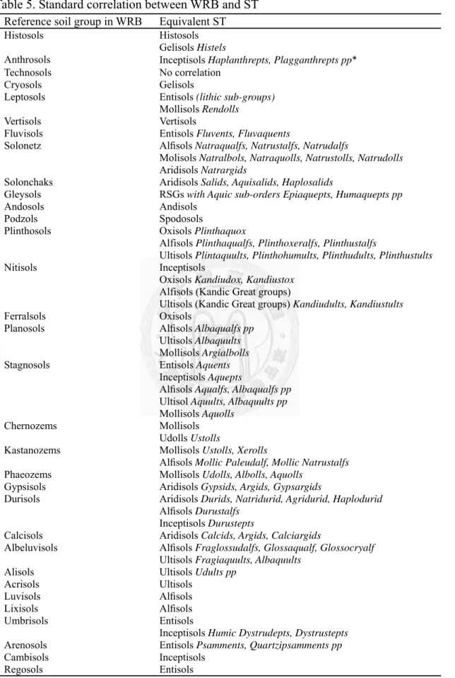
3.3 WRB 與 ST 的對應
將同一土系 (或土壤) 分別在 WRB 與 ST 兩系統下的結果列出後對應,並引 用Shi et al. (2010) 及 Zádorová and Penížek (2011) 的對應度計算方法,將符合標準 對應的土壤數除上總土壤數而得到對應度,最後依各土壤的比例加權平均後得到 總對應度,如此可利用對應度做為判別不同系統對應及轉換是否可信。
ST 的結果將引用並適度修正陳等人 (2000) 利用美國土壤分類系統 (Soil Survey Staff, 1999) 將全臺灣農地土系分類的結果。而 ST 與 WRB 的標準對應關係 (表 5) 則收集自 IUSS Working Group WRB (2006) 及 Gray et al. (2011) 的內容並 加以統整而得。對應情形的撰寫將依各縣市順序,個別討論各地區土壤在WRB 與 ST 兩系統對應的情形及無法標準對應的原因。WRB 及 ST 列出的土壤單位分別至 修飾詞 (包含參考土類及修飾詞) 及大土類 (包含土綱、亞綱及大土類),但事實上 各對應的層級皆依標準對應表而定 (除部分對應討論到參考土類 vs.大土類,大多 討論層級僅涉及參考土類 vs.土綱)。最後,另立一章節 (4.3),除總結無法標準對 應的原因,並列出全部土壤在兩大系統下對應的對應度及無法標準對應的結果。