以荷蘭氣候變遷減災調適經驗探討我國空間規劃之策略方向-與水共生的空間
136
0
0
全文
(2) 國科會 GRB 編號:PG9710-0221 內政部計畫編號:097301070000G2024. 以荷蘭氣候變遷減災調適經驗探討我國空 間規劃之策略方向-與水共生的空間. 研 究 人 員:林 育 慈. 內政部建築研究所研究報告 中華民國九十七年十二月.
(3) 目次. 目 次 目次‧‧‧‧‧‧‧‧‧‧‧‧‧‧‧‧‧‧‧‧‧ Ⅰ 表次‧‧‧‧‧‧‧‧‧‧‧‧‧‧‧‧‧‧‧‧‧ Ⅱ 圖次‧‧‧‧‧‧‧‧‧‧‧‧‧‧‧‧‧‧‧‧‧ I 摘要‧‧‧‧‧‧‧‧‧‧‧‧‧‧‧‧‧‧‧‧‧ Ⅳ 第一章 緒論‧‧‧‧‧‧‧‧‧‧‧‧‧‧‧‧‧‧1 第一節 研究緣起與目的‧‧‧‧‧‧‧‧‧‧‧‧1 第二節 研究內容與範圍‧‧‧‧‧‧‧‧‧‧‧‧4 第三節 研究方法與步驟‧‧‧‧‧‧‧‧‧‧‧‧6 第四節 預期成果‧‧‧‧‧‧‧‧‧‧‧‧‧‧‧8 第二章 氣候變遷與災害衝擊‧‧‧‧‧‧‧‧‧‧‧ 9 第一節 氣候變遷現象與未來情境模擬‧‧‧‧‧‧10 第二節 氣候變遷之於全球與亞太地區之衝擊‧‧‧22 第三節 氣候變遷衝擊調適策略之國際發展‧‧‧‧31 第四節 政府部門因應氣候變遷減災調適之研究‧‧40 第三章 荷蘭空間規劃制度與氣候變遷調適‧‧‧‧‧ 48 第一節 荷蘭空間發展與災害背景‧‧‧‧‧‧‧‧48 第二節 荷蘭天然災害背景與水患治理‧‧‧‧‧‧ 56 第三節 因應氣候變遷之減災調適作為‧‧‧‧‧‧63 第四節 治水與空間規劃策略、技術演進與調適‧‧73 第四章 氣候變遷趨勢下國土與都市空間規劃課題‧‧‧ 81 第一節 氣候變遷對國土與都市環境之衝擊‧‧‧‧‧ 81 第二節 從空間規劃看水資源管理議題‧‧‧‧‧‧84 第三節 氣候變遷下之空間規劃調適方向‧‧‧‧‧89 第五章 結論與建議‧‧‧‧‧‧‧‧‧‧‧‧‧‧‧ 93 第一節 結論‧‧‧‧‧‧‧‧‧‧‧‧‧‧‧‧‧93 第二節 建議‧‧‧‧‧‧‧‧‧‧‧‧‧‧‧‧‧101 附錄一‧‧‧‧‧‧‧‧‧‧‧‧‧‧‧‧‧‧‧‧‧104 附錄二‧‧‧‧‧‧‧‧‧‧‧‧‧‧‧‧‧‧‧‧‧105 附錄三‧‧‧‧‧‧‧‧‧‧‧‧‧‧‧‧‧‧‧‧‧108 參考文獻‧‧‧‧‧‧‧‧‧‧‧‧‧‧‧‧‧‧‧‧112. I.
(4) 表次. 表 次 表 2-1 21 世紀末全球平均地表溫度升高與海平面上升預估‧‧ 14 表 2-2 氣候變遷與環境、部門脆弱度關係‧‧‧‧‧‧‧‧‧24 表 3-1 第四版國家氣候變遷通訊中的荷蘭氣候變遷衝擊‧‧‧ 68 表3-2 第四版國家氣候變遷通訊的荷蘭氣候變遷調適措施‧‧70 表 4-1 一般的與調適的觀念與作法比較‧‧‧‧‧‧‧‧‧‧89 表 4-2 結合水資源管理的都市空間規劃調適方向‧‧‧‧‧‧91 表 5-1 荷蘭與我國地理條件、災害背景與制度比較‧‧‧‧‧94. II.
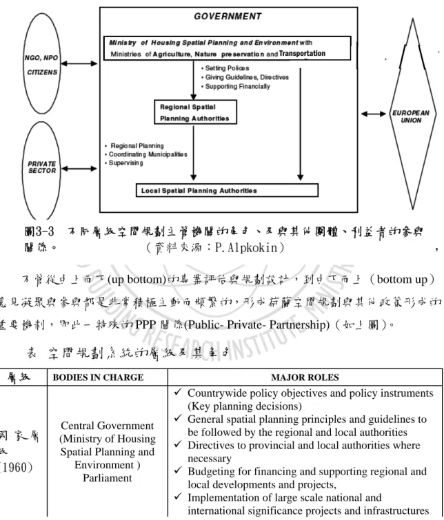
(5) 圖次. 圖 次 圖 1-1 減災與調適策略關係示意圖‧‧‧‧‧‧‧‧‧‧‧‧5 圖 1-2 研究計畫流程圖‧‧‧‧‧‧‧‧‧‧‧‧‧‧‧‧‧7 圖 2-1 IPCC2007 評估報告內容與發布時間‧‧‧‧‧‧‧‧‧11 圖 2-2 過去 150 觀測到的全球均溫、海平面與北半球積雪變化 12 圖 2-3 溫室氣體增加趨勢‧‧‧‧‧‧‧‧‧‧‧‧‧‧‧‧13 圖 2-4 2090-2099 年與 1980-1999 年預測之氣溫差距‧‧‧‧‧ 15 圖 2-5 台灣地區年平均溫度分布圖(SRES-A2)‧‧‧‧‧‧‧18 圖 2-6 台灣地區年平均溫度分布圖(SRES-B2)‧‧‧‧‧‧‧18 圖 2-7 台灣地區夏季平均溫度分布圖(SRES-A2)‧‧‧‧‧‧19 圖 2-8 台灣地區冬季平均溫度分布圖(SRES-A2)‧‧‧‧‧‧19 圖 2-9 台灣地區夏季平均溫度分布圖(SRES-B2)‧‧‧‧‧‧20 圖 2-10 台灣地區冬季平均溫度分布圖(SRES-B2)‧‧‧‧‧20 圖 2-11 台灣地區雨季平均降雨量分布圖(SRES-A2)‧‧‧‧20 圖 2-12 台灣地區乾季平均降雨量分布圖(SRES-A2)‧‧‧‧21 圖 2-13 台灣地區雨季平均降雨量分布圖(SRES-B2)‧‧‧‧21 圖 2-14 台灣地區乾季平均降雨量分布圖(SRES-B2)‧‧‧‧21 圖 2-15 全球氣候變遷衝擊面向‧‧‧‧‧‧‧‧‧‧‧‧‧‧22 圖 2-16 洪水災害帶來的風險程度‧‧‧‧‧‧‧‧‧‧‧‧‧26 圖 2-17 氣候變遷與調適行動關係圖‧‧‧‧‧‧‧‧‧‧‧‧31 圖 2-18 UNFCC 中各國適應方案建立之系統架構‧‧‧‧‧‧34 圖 3-1 荷蘭國土與都市分佈概況‧‧‧‧‧‧‧‧‧‧‧‧‧49 圖 3-2 三級制與水管局的位階‧‧‧‧‧‧‧‧‧‧‧‧‧‧50 圖 3-3 不同層級空間規劃主管機關的角色、及與其他團體、利益 者的參與關係‧‧‧‧‧‧‧‧‧‧‧‧‧‧‧‧‧‧52 圖 3-4 荷蘭低於海平面及易受水患威脅之地區‧‧‧‧‧‧‧56 圖 3-5 須得海變成艾瑟湖(Ijsselmeer) ‧‧‧‧‧‧‧‧‧‧‧58 圖 3-6 荷蘭典型的治水與土地利用模式 ‧‧‧‧‧‧‧‧‧ 62. III.
(6) 圖次. 圖 3-7 氣候變遷空間規劃計畫之主要概念圖‧‧‧‧‧‧‧‧ 65 圖 3-8 氣候變遷空間規劃計畫組織圖‧‧‧‧‧‧‧‧‧‧‧ 66 圖 3-9 全球平均溫度上升與大氣環流變化的模擬境況‧‧‧‧ 67 圖 3-10 荷蘭夏季平均氣溫的變化趨勢‧‧‧‧‧‧‧‧‧‧ 67 圖 3-11 溫室氣體排放量維持現況之全球平均溫度上升趨勢‧68 圖 3-12 Delta Commission 委員組成‧‧‧‧‧‧‧‧‧‧‧‧74 圖 3-13 荷蘭還空間於水之案例與策略示意圖‧‧‧‧‧‧‧77 圖 3-14-1 還地於河策略的概念圖‧‧‧‧‧‧‧‧‧‧‧‧‧80 圖 3-14-2 2008-2050 執行策略示意圖‧‧‧‧‧‧‧‧‧‧‧80 圖 4-1 台灣氣候變遷現象、衝擊與空間規劃因果關係圖‧‧‧83 圖 4-2 現行水利主管與相關機關與執掌‧‧‧‧‧‧‧‧‧‧87 圖 4-3 現行水利事權圖‧‧‧‧‧‧‧‧‧‧‧‧‧‧‧‧‧87 圖 5-1 漂浮屋案例‧‧‧‧‧‧‧‧‧‧‧‧‧‧‧‧‧‧‧83 圖 5-2 荷蘭馬斯河(Mass)岸的漂浮屋‧‧‧‧‧‧‧‧‧‧56. IV.
(7) 摘 要 關鍵詞:空間規劃、氣候變遷、調適 一、研究緣起與目的 我國的地理環境與土地利用狀況,屬於氣候變遷衝擊下高災害脆弱度的 國家,在世界銀行 2005 年"Natural Disaster Hotspots: A Global Risk Analysis"研究報告指出,台灣約有 73%的人口居住在有 3 種以上災害可能 衝擊之地區,很可能為世界上最易受到天然災害衝擊地區之一,加上氣候變 遷與氣候極端事件更增加都市脆弱度劇,因應氣候變遷的減災調適準備尚待 政府部門的整合與民眾參與。荷蘭與我國國土面積相當,都市人口集中,地 勢低窪而且歷史上發生多次水患,對氣候變遷敏感度極高、政策因應與相關 研究計劃累積很多作法與經驗,值得台灣借鏡。 在氣候變遷與極端事件證據日趨明顯之際,國土與城鄉空間規劃的調適 減災策略益形重要,國內的氣候變遷調適行動目前尚未有國家型或跨部門之 政策研擬,而荷蘭與我國國土、人口規模相當、80%人口居住在 2 萬人以上 的都市;災害害脆弱度亦高,長期處於水患威脅而有新觀念與先進技術,自 1995 年開始於官方政策中呼應氣候變遷議題;於 2006 年正式提出國家型的 氣候調適計畫,有與空間規劃連結的規劃程序、政策、經驗,將在本研究中 探討。 研究目的包括解先進國家在空間規劃政策上因應氣候變遷的調適方 法;探討荷蘭在因應氣候變遷、與災害共處之思維下,所研訂之規劃政策? 計畫內容為何?有何創新建議與操作方式?日後如何執行?預期效益為何? 綜合整理其調適策略與創新作法,作為我國空間規劃部門,提出長期性、預 防性之氣候變遷調適政策之參考,最後提出往後科技計畫方向與課題。. IV.
(8) 摘要. 二、研究方法及過程 本研究計畫針對國內外之相關研究報告、氣候變遷調適減災方向、空間 規劃因應氣候變遷的調適方向歸納比較及分析;並研究目前國內之國土空間 規劃政策對氣候變遷的因應現況,從荷蘭經驗檢討我國空間規劃制度與因應 氣候變遷之關連性,提出政策性建議與後續研究方向。 三、結論 荷蘭在歷史上是一個洪澇和風暴潮災害十分嚴重的國家。長久以來採取 結構性措施來抵禦水災,有其在水災威脅下的空間規劃與制度設計,而以其 國土為世界上 40 個最大的河口三角洲之一,在氣候變遷衝擊下,屬於脆弱度 最高的地區,因而公私部門對相關調適策略的研擬與推動,予以高度重視。 (一)荷蘭與我國空間規劃背景之差異 荷蘭不在板塊活動帶上,加上地勢相對低平,因此,地震、坡地災害並 非荷蘭的主要天然災害威脅。歷史上有許多冬季的風暴潮及洪水引起的災 害,雖然目前荷蘭已進行須得海工程及三角洲工程等工程,而全國的堤防安 全標準也提昇至海岸地區 1 萬或 4 千洪水頻率年、東部 1250 洪水頻率年的標 準。然而,面對以泥沼為主的土地持續沈降(每百年平均約沈降 10cm),另 一方面,因地理條件的限制,可發展空間有限,城市相當緊密,人口稠密且 高度城市化,尤其是全國的經濟重心的蘭斯塔德地區,尤其深受氣候變遷下 的海平面上升及降雨頻率改變衍生的河川、海水威脅。 因此荷蘭與我國雖在國土面積相當、人口集中、高度都市化方面有相似 特性,然背後的國情、制度上有很大的差異,其特殊的環境及高密度的發展, 歷史上的城鄉發展反映出不少環境的限制;例如土地近乎國有、因此公部門 在土地利用上具有主導權;其次,中央稅收有四成作為社會福利使用,中央 稅收佔九成,透過預算分配引導省、地方的建設計畫,因此在財政、土地利 用與建築開發方面具有中央集權的特色。 近年來,荷蘭特別關注全球暖化所造成的環境衝擊,進而發展出多面向 的減災及調適策略,其中亦包含空間規劃的面向。洪氾區為堤線之範圍,而. V.
(9) 非自然的洪氾平原。此外,荷蘭僅較受水災威脅,其思考災害管理上,仍著 重於從水的系統來處理;在空間規劃的減災及調適策略上,荷蘭則偏重於政 策方向。 荷蘭的水資源管理與開發利用,乃是將空間規劃、社經影響、環境再造 及地景政策都納入評估,再經政府單位、相關機關與民眾團體溝通,形成復 育規劃方案,例如規劃預算約台幣 800 億元,擬將沿海鬱金香種植區內遷, 海邊留作綠地與濕地,同時搭配水質淨化與再利用。 (二)荷蘭經驗對我國空間規劃政策擬定之啟示 本研究以荷蘭因應全球氣候變遷現象所造成衝擊與議題為主軸,探討其 規劃經驗,繼而檢討臺灣國土空間規劃,並由相關部會推動之政策與計畫的 蒐集與彙整,發現目前國土規劃政策在因應全球氣候變遷之不足,再參酌荷 蘭之對應作法,進而研擬我國全球氣候變遷下國土或都市空間規劃制度上、 策略上的調適方向。因此,透過上述內容之執行,提出可供我國參採的思維、 策略、制度方面的作法如下: 第一部份:荷蘭規劃與推動因應氣候變遷措施的重要思維: 1、 新 Delta Commission 的政策建議報告指出,荷蘭以往的防洪工作 相當完備,因而近年沒有嚴重洪災發生。但在全球氣候變遷的衝 擊下,風險將持續升高,若荷蘭人民已淡忘洪災的可怕,予以輕 忽,將使荷蘭步入災難性的境況。 2、 為了形成具體有效的行動,必須提昇政策對調適作為的支持。因 而,參與氣候變遷相關研究、規劃的機構與人員,均致力於與所 有利益相關者(stakeholder)溝通,使民眾與決策者均能充份瞭解 重要觀念與知識,進而產生明確的政策目標,以及適切的推動策 略。 3、 在氣候變遷的衝擊下,洪災與水資源管理遭受到的威脅是顯而易 見的,若要有效因應,必須與空間規劃一併處理,使可強化系統 性的調適能力。甚至可藉由此契機,一併改善潛在的社會與經濟 問題,提昇國家整體競爭力。. VI.
(10) 摘要. 4、 必須長期投入因應氣候變遷的調適作為,同時,應密切監測環境 變化,對於相關調適策略持續檢討修訂。為使相關工作能夠順利 推動,必須有政策、行政管理、法規與財務之妥適配合。 5、 針對不同環境區域研擬調適策略的過程中,非常重視知識的交流 與彙集,並投入可觀資源建構國內與國際的知識交流平台,此舉 可有效的持續檢視與改善相關工作進展情形,對於氣候變遷衝擊 評估與調適作為之長期推動,將有相當大之助益。 6、 除了透過各部門計畫之因應策略外,另提出 CcSP 計畫以及氣候情 境模擬、減量、調適、整合與資料傳遞等五個主題,以作為空間規 劃模擬之指導原則。. 7、 從「與天爭地」的土地利用到「還地於水」的空間規劃與水資源 管理思維 第二部分:因應氣候變遷的減災調適策略與作法 1、 尊重水資源,將永續的治水、用水觀念,揭諸於具法源的國土規 劃政策,並融入各級空間規劃與土地利用方案中 2、 明確的國土空間規劃法制與目標,預算分派進行資源配置 3、 確立「還地於水」、「還地於自然」(Room for the river 或 space for water and nature)為空間規劃與決策的最高指導方針 4、 水資源管理、生態保育、減災調適多目標的土地使用與空間規劃 策略 生態手段成為荷蘭策略性土地規劃的指導原則,自然地區以廊道 串連,而河川不再只是提供運輸與水源,而是成為遊憩地區與生 態系統的一部份,空間規劃與土地利用在永續、防災的原則之下 進行。 5、 結合不同利益團體、民眾的參與 6、 採用成本效益分析法,評估各種調適方案推動優先順序,涵蓋空 間規劃調適策略與構想,目前優先推動的調適策略有:. VII.
(11) (1) 為因應氣候變遷,將投資台幣 1,110 億,到 2050 年前完成 因應全球氣候變遷之土地利用雨水管理計畫。 (2) 進行國土規劃,還地於海,減少海岸邊土地開發, 設計 bypass,規劃濕地及洪水平原。 (3) 進行海平面上升之淹水模擬,標示高度危險區域,依海面 上升程度擬定不同因應策略。 (4) 建築結構物設計開始考量如何因應海水位上升,如學者提 出可以隨水位調升的綠建築都市,建築師設計兩棲住宅 (Amphibious Houses)、漂浮建築(Floating Architecture)等, 學生競圖提出漂浮城市等概念。(如下圖) (5) 結合防洪、景觀、生態規劃 (6) 將河流兩岸的堤防往外移,增加行水面積和蓄洪量,回復 河川原有的蓄洪力及生態功能,不但可徹底解決水患,也 可創造人類、河川和土地的新關係。 (7) 將部分填土所造陸地還給海洋,讓岸邊的陸地成為自然滯 洪區。 (8) 將氣候變遷對河川流向與海平面升高的影響,反映在公共 設施的設計中。 7、 結合水利、都市計畫及建築管理手段進行跨領域的合作,融合土 地利用、水資源管理與減災工作,運用工程方法與非工程方法, 規劃與水共生的居住或休憩環境。 8、 跨區域的治理、土地承擔一定災害 氣候變遷不會衝擊所有地方,然威脅或災害形成是不會遵循著人 為的行政疆界,因此跨區域的因應措施,如採取流域管理的方 法、考量生物地理區的觀點,藉國家、區域、地方階層執行或落 實為必要。而這些和諧共處的地區除居民有安全保障外,土地亦 要承擔一定的洪水災害,並建立民眾風險意識與配套補償機制。. VIII.
(12) 摘要. 9、 荷蘭空間規劃的模式(Dutch Mode)有其土地多屬國有的規劃彈 性,但在制度設計上並沒有忽略民眾參與(PPP),形成氣候變 遷調適策略與推動方案過程均將民眾參與、對利益團體的溝通, 所需花費的時間與金錢成本算入,進行分期規劃,雖可能影響時 效,但溝通過程中達到政策宣導的目的,利於後續方案的推動。 10、 荷蘭政府基於確保國土安全、免於水患的國家指導原則,以及 面對氣候變遷引致的水患威脅日增,提出還地於水、將更多的空 間與土地還給河流,此一政策揭示與散見於不同部門的文件中, 各層級的水利單位在進行水資源管理時,有憲法賦予的權利推動 進行防止水患發生的政策與方案,而經濟發展的情勢與需求也反 映在國家規劃政策中,當開發與「還地與水資源管理的政策」衝 突時,以後者為優先。 第三部分:調適或減災方面的策略方向應用上的限制 1、 台灣災害型態更複雜:臺灣 3/4 為坡地,土地大多是高山、丘陵, 多坡地災害;實際平地面積相較之下約只有荷蘭的三分之一,荷 蘭的人口又只是臺灣人口的三分之二,因此相較之下臺灣地狹人 稠,加上土地私有制,土地作為開發管制的籌碼甚少,可利用的 公有土地更少,在推動還地於河的觀念時,相關單位需要更多的 魄力與決心。 2、 減少氣候變遷引致災害的措施可預先做,但要考量各方立場,如 遷村必然會引起反彈而需審慎處理,有待最適化的方法,但因調 適策略不是零合遊戲,行動方案奠基在最大集合的共識。 3、 荷蘭所採用的調適、減災策略,有還地於水,涉及大規模搬遷, 該情境如發展於臺灣因土地制度的差異,需有配套補償機制,實 施上需要由下而上、風險溝通等策略開始,較具困難性。 四、建議 氣候變遷在臺灣高度可能發生的現象包括海平面上升、降雨改變、氣溫 上升與臭氧層破壞,衍生的負面衝擊有海岸退縮、生態系統改變、農林漁牧. IX.
(13) 衝擊、水供給問題、土砂災害、洪旱災害、疫病傳染與能源使用改變等等, 有待檢討的國土空間規劃與城鄉土地利用方式,與海岸保育、生態系統保育、 糧食安全維護、水資源管理、土壤保護、天然災害防制、公共衛生防制與能 源管理等議題交錯影響,在本研究範疇中,從政策作法、策略、法規類別角 度提出下述建議與後續研究課題。 一、政策研訂與推動機制方面 (一)氣候變遷調適政策綱領擬定與機制設計 國內因應氣候變遷雖有國家永續發展委員會為最上位機關,然氣 候變遷議題牽涉部門廣泛,政府各部門衝擊影響之科研推動與政 策制訂,仍須進一步擬定積極的整合機制,以便有效推動氣候變 遷相關研發工作與政策擬定。 國土三法尚在修訂與立法階段,參酌荷蘭國土規劃架構與法制, 確立永續與安全為各項政策、方案、計劃的最高指導原則,災害 脆弱地區、環境敏感地區明確指定限制開發,確立留給水域與自 然環境更多的開發指導原則,再強化「還地於水」、「水資源保 育與管理」的觀念,調整草案內容,以回應溫度上升、降雨頻率 改變、暴雨、海平面上升等明確的氣候變遷趨勢。並由經建會提 出氣候變遷調適政策綱領,作為各部會匡列預算經費之指導原 則,並開始進行政府部門橫向與縱向的溝通宣導。 (二)逐步轉化與應用氣候變遷衝擊、調適與災害管理之研究成果 國內之氣候變遷研究與政策過去多以溫室氣體減量為主,近年來 由於國內外災害頻傳,衝擊與調適策略相關研究雖逐漸受到重 視,放眼未來仍須進一步強化跨領域之整合研究與方法論之建 立,如不同災害類別的脆弱度與風險分析、考量不同層級(如地 區、國家、區域發展)的調適工具建立與災害管理與永續發展之 策略擬定等。國內的相關研發仍有許多待加強的空間,如氣候變 遷下各災害脆弱度風險地圖的製作,亟需相關專業領域之共同研 析與合作。 (三)民眾風險溝通:與災害風險共生(living with risk). X.
(14) 摘要. 民眾意識建立之重要性,雖然氣候變遷近年受到關注,但一般民 眾對氣候變遷的危機意識較低,因此,提高公眾對氣候變遷的認 識,是具有其必要與優先性,最終方得以透過簡單變化生活的方 式作為減緩氣候變遷的行動。因涉及議題廣泛,公眾意識的政策 可能會有所變動,然而一些措施是共同的,包括:訊息、教育和 訓練;公眾和利益相關者的參與;賦予人民權力和動機,對氣候 變遷的影響採取有效行動,讓民眾體會如何與災害風險共生 (living with risk)。 二、調適減災策略方向 (一)精進氣候變遷推估能力(主辦:經濟部、國科會、交通部) 因應氣候與環境變遷之脆弱度分析與變遷模擬所需,需強化山區 與集水區降雨監測、附近海溫、海水位、河川水位與流量、水質 監測、地層下陷程度、海岸變遷、土地利用、植被與土水監測等 資料之監測與資料庫之建立。而氣候與環境變遷事涉不同領域之 資料、資訊與知識庫,建立因應氣候與環境變遷之資訊整合平 臺,統一格式與展示介面,以利於變遷研究與整合分析之用。 (二)氣候與環境變遷災害管理調適策略之擬定 因應氣候與環境變遷之災害管理調適策略,須與國土政策規劃與 環境永續利用緊密結合,應用氣候與環境變遷下之巨災衝擊情境 模擬、社會經濟發展情境模擬;系統性整合自然環境承載力管 理、人為防災系統建構與社會經濟發展決策,強化調適能力與預 警機制,以便即時採取事先規劃且具操作性的應變調適策略。 (三)以國土空間為主軸,由各相關部會進行策略研擬,再形成「整體 國土空間策略」 目前國內相關國土空間計畫與法令皆尚未針對全球氣候變遷議 題進行因應措施之研擬,而各部會相關政策與計畫又大多停留在 研究與分析階段,缺乏能落實於土地規劃之相關策略。因此本研 究建議應以國土空間為主軸,由各相關部會分別根據「生態資 源」、「水資源」、「能源」、「天然災害預防」、「農業發展」. XI.
(15) 與「城鄉發展」等,再透過「整體國土空間策略」串連各部會之 計畫,以有效落實於國土空間上。 (四)從 30-50 年後的最大衝擊情境,檢討土地利用與管理法令 以台北市為例,面對缺水、增溫、驟雨、海平面上升等氣候變遷 問題,嘗試從 2030 年時台北會發生什麼事來作研究,重新評估 易淹水地區是否有高產值的土地利用、現有土管都設規定是否應 有調整、檢討道路設計、建築發電機與維生系統的放置樓層是否 調整、是否強制規定新開發建築設計綠屋頂以短暫分散都市瞬間 暴雨。. XII.
(16) Planning with the Water: Learning the Dutch Experience of Adapting to Climate Change to Suggest Spatial Planning Policies and Strategies in Taiwan. Summary Keyword: climate change, spatial planning, adaptation, mitigation. The Purpose of this Research Taiwan is classified as highly vulnerable to climate change due to the nation’s geological environment and landuse pattern. The World Bank’s report published in 2005 “Natural Disaster Hotspots: A Global Risk Analysis” indicates Taiwan is situated on one of the most hazardous natural climate impact region, with 73% of the population living in more than 3 possible natural disaster impact zones. With climate change and occurrences of extreme weather, the deterioration of urban environment vulnerability will only magnify. National and urban spatial planning policies and strategies are needed to be adjusted to cope with increasing disasters impacts caused by climate change. The Netherlands occupies similar land area and population density as Taiwan, with the lowlands being susceptible to frequent flooding and dependent on climate stability, the strategies, research and experience is something to learn from. The evidence of climate change can be seen in the occurrences of extreme natural events happening in recent ages. The importance of damage mitigation through settlement planning is becoming more and more pressing. Currently there are no national or inter departmental policies to deal with the impact of climactic changes. Netherlands is similar in territory and population to Taiwan, with 80% of the population living in cities with 20 thousand people or above. The nation is highly vulnerable to natural disasters and often threatened by flooding and combats this threat by innovative technologies to mitigate the threat. Since 1995 Netherlands has outlined the threat from climate changes in governmental policies and has brought forth a national climate mitigation plan in 2006. The plan incorporates spatial planning with planned procedure, policies and integrates previous experiences and will be discussed in further detail in this research. The aim of this research sets out to understand how advanced nations adapt their national policies and special planning in order to adjust to climate changes; this report.
(17) will discuss how the Netherlands establish their national policies with climate change and potential natural disaster, the content and innovative ideas and management methods, future implementation and what are the expected benefits? These strategies and innovative methods is summarised to provide our nation with a long-term preventative policy and spatial planning to adapt to future climate changes.. Research method and Procedure First, we will categorize and analyse related international and internal literature and reports on climate change and damage mitigation and adaptive spatial planning to climate change. Second, we will study into our current national spatial planning and policies to climate change hazards. Thoughts can be compared between the Netherlands experience and our national climate change hazard solutions to formulate appropriate policies suggestions and future research direction.. Background of Netherlands and Taiwan’s spatial planning Netherlands is safely located out of the tectonic plate movement regions and has relatively low lands. Earthquake and mudslides are not the main natural threat to the Netherlands. Historically numerous winter storms and flooding caused much of the natural damages. Although currently the nation is undergoing numerous harbor and river and delta projects, with the nation’s dike safety standard to be raised to 10-4 thousand annual flood frequency (AFF) and the Eastern regions are set at 1250 AFF. However, the swamp lands in this country continue to sink at a rate of 10cm/year. In addition, developable land in this country is also limited and the cities are closely packed, resulting in high population density and a high degree of urbanisation. This is especially so in the economic centre of Randstad, which is under a serious threat of both raising sea levels and changing river and coast due to rain pattern changes. Although Netherlands is similar to Taiwan in terms of territory area, population density and both have a high degree of urbanisation, there is a significant differences in the national structure. Historically this has been reflected in township and country development limitations; examples include a high degree of national land ownership, providing governmental development high domination in land use planning. In addition, 40% of the taxes are used in social benefits, 90% of regional construction funds comes from the tax revenues. A characteristic of highly centralised control is found in land use and construction projects. In recent years Netherlands has place further attention to the environmental impacts of.
(18) global warming and has developed multiple directions in damage mitigation and adaptation, which also include spatial planning. Further, flood plains are limited by the dike structures rather than nature flood lines. As the Netherlands is more susceptible to flooding, their natural disaster management concentrates upon water management; as a result, they lay great emphasis on its national damage mitigation and adaptation policies. Water resources planning in the Netherlands incorporates special planning, societal and economic impact, environmental and landscape policies. Governmental departments communicate with regional communities to establish a recovery strategy. An example might be a budget of 80 billion NT will be utilises in transfer coastal tulip plantations to further inland to leave the coast as natural wetland while improving water quality and reuse.. The Dutch experience and ideas for our national spatial planning policies This research first discusses the impact and concerns of climate changes in the Netherlands and their policies and returns to Taiwan’s own spatial planning. Through the understanding of relevant policies and plans, Taiwan’s national policies to climate change impact are insufficient. By formulating a new national territory and city planning by consulting Netherlands adaptation solutions, the following ideas, strategies and policies is suggested by the research: Part 1: Key ideas in Netherlands policies due to climate change 1. According to Delta Commission’s policy reports, the construction in past flood dams are sufficient as there has been no major flooding occurring in recent years. However, in the impact of international climate changes, the potential of flood damage is rising and the people of Netherlands must not become complacent to the damages of flooding so that they will not experience such disaster again. 2. Support is essential for effective action, therefore research and planning personnel associated to climate change must communicate to the stakeholders. So that the people and the policy makers have sufficient understanding and knowledge to make the correct policy goals and implement suitable strategies. 3. The threat of flooding and water resource management is apparent due to climate change impacts. Spatial planning must be addressed in order to respond to the problems and strengthen system adjustability. It is even possible to improve hidden social and economical problems while addressing these issues and beneficially raise the national competitiveness..
(19) 4.. 5.. 6.. 7.. Long-term adjustments are required to solve problem from climate changes. In the mean time close monitoring of climate changes allows for appropriate adjust and work to be carried out successfully. National policy, administrative management, regulations and finance must be integrated. The exchange of information and data is essential for cross-environmental climate regions when forming adjustment strategies. Substantial resources are needed to develop national/international information exchange platforms, this will benefit continuous monitoring and improvement to the work carried out. The information platform will support climate change impact assessment and its relevant long-term adjustments and execution. Other than various departmental response strategies and plans, CcSP as well as the five key topics (climate simulation, reduction, adjustment, reorganise and data transfer) can be used as guidelines for spatial planning. Shift from “acquiring more lands” to the mindset of “room for river” as the future thought of water management and spatial planning.. Part 2: Adapting to climate change . 1. Respect the water resources by integrating sustainable water regulation and usage into national land laws and follow all stages of spatial planning and land use proposals. 2. Clear national spatial planning laws and aims. Budget planning should also be conducted for appropriate resource distribution. 3. Thought of “room for the river” and ”space for water and nature” as the utmost guidance in spatial planning and decisions. 4. Multiple objectives (water resource management, environmental protection, damage mitigation and adaptation) are included in land use and spatial planning strategies. Environmental protection actions are one of the guidelines for Netherlands strategic land planning. Corridors connect ecological regions and rivers are a part of recreational and the local ecological system rather than just for transportation and water. Spatial planning and land use are carried out under the principles of sustainable management and disaster prevention. 5. Incorporating interest groups and public participation in decision making. 6. Incorporate cost-benefit analysis to determine the order of adaptation proposals. These proposals must follow spatial planning strategies and concepts, currently adaptations strategies with priorities are: (1) As a response to climate changes, 111 billion NT will be invested by 2050 for the utilisation of rainwater due to global climate change. (2) Carry out national land planning, marine restoration, reduce coastal land.
(20) development and designs bypass for wetlands and flood plains. (3) Simulate rising sea level flooding and mark out high hazard regions to develop responding strategies against different sea level rises. (4) Architectural designs can provide answers how to deal with rising sea levels. Academics have suggested green cities capable of rising with the water levels. Architects design amphibious and floating houses. The floating city concept is also brought up in student competitions . (See picture below) (5) Incorporate flood prevention, landscape and ecological planning in spatial planning. Examples include government purchasing land near riverbeds for recreation and sports while providing space for water during storms or flash floods. (6) (7) Return created land in the coast to the ocean, allowing coastal land to become flood buffer regions. (8) Build public facilities taking into account of rising sea level and river path changes as a result of climate change. 7. Combine water regulation, city planning and building management to create a cross-disciplinary cooperation. Merging land use, water resource management and damage mitigation through engineering and non-construction methods to ensure a habitable environment with water. 8. A cross-regional management system to let land bear some damage. Climate change may not impact all regions in a nation, however the extent of the damage will not follow boundaries as defined by people and this will become a problem with regional management of natural hazards. As such, a cross-regional management, such as river basin management, taking the point of bio-geographical divisions into account, is necessary. Further, above should work with a top-down concept from national, regional and local level execution to provide protection to the citizens. In addition to certain expected damage from flooding, a comprehensive compensation system should be in place as well as risk awareness education to the people. 9. Dutch mode spatial planning model with high percentage of national land for flexible planning while still incorporating peoples participation programme (PPP). The cost of incorporating communication with interest groups may be time consuming due to staging progress for communication. However, during the communication progress the government achieves strategies guidance and education that will be beneficial to future proposals. 10. With safety and flooding prevention as the national directive principles, the Netherlands government proposed room for water and other similar policies to.
(21) return space and land to the river in order to prevent climate change hazards. The policies can be seen in various governmental agencies. In addition, the agencies have the power of the constitution to actively promote disaster prevention during in water resource management policies and proposals. The need for economy may conflict with damage mitigation policies and the latter should take precedence. Part 3: The limitations of damage mitigation policies application 1. The Taiwan situation may be more complex: 3/4 of Taiwan’s land is hills and mountainous regions and is vulnerable to mudslides; the actual flatlands are only 1/3 of Netherlands. In addition, the population number of the Netherlands is only 2/3 of the Taiwanese population. Private land ownership has higher percentage in Taiwan with the developing agencies having less power with the lack of national land. The execution of room for river may require much more determination and power from the authorities. 2. Damage mitigation from climate changes can be pursued with consideration from multiple viewpoints. Major changes such as village relocation may encounter resistance and needs to be treated carefully to find the best solution. However mitigation strategies are not zero-sum games and action must have the agreement from multiple parties. 3. The Netherlands room for river and major relocation schemes for damage mitigation may have problem under Taiwan’s current state of land ownership, accompanying compensation schemes, bottom to top execution and the risk in communication all pose further difficulties.. Suggestions Climate changes in Taiwan will result in rising sea levels, change in rainfall patterns, temperature increase and damage to the ozone layer. Negative impacts from these phenomenons are coastal retreat, change in the ecological systems, impact to the agricultural and fisheries, water supply problems, soil erosion, flooding or drought, disease and changes to resource use. National territory spatial planning and land use need to be discusses, with coastal environmental protection, ecological protection, maintenance of food source, water resource management, soil protection, natural disaster prevention, public health systems and energy management all influences future strategies. In this current scope of research, we propose recommendations for future research through policymaking, strategies and law making..
(22) Policymaking and institutional adjustments 1. Climate change mitigation policies and overall system proposal Climate change impact is the responsibility of the National Council for Sustainable Development. However climate change topic is a wide-ranging, multiple department spanning policy and require cooperation from the various agencies. Further step in outlining a more pro-active overall system must be in place to ensure the success of climate change impact research and policymaking. The 3 National Land Laws are still in amendment and legislative process. The advice from Netherlands national land planning structure and laws is taken as a reference to ensure sustainability and safety as the highest priority in policies, proposals and planning. Limit development in regions prone to natural hazards or environmentally sensitive regions, ensuring clear-cut and guidance for the protection of water and natural regions, enforce room for river and space for water and nature concepts. Adjust proposal contents to reflect rising temperature, changes in rainfall patterns, rising sea level trends. The Council for Economic Planning and Development needs to propose climate change mitigation policies guidelines and apply it to the national budget distribution. In addition, vertical and horizontal communication and education between governmental departments is needed to spread the concept. 2. The application of disaster management research to the continuing application of climate change impact mitigation. Previous national climate change research was based on reduction in greenhouse gases; however, recent events of national/ international climate impacts are gaining attention for more mitigation strategies. Looking ahead the need for the establishment of cross disciplinary research such as different disaster risks and vulnerabilities analysis, different level (local, national, regional) mitigation implementation and disaster and sustainable management need to be strengthened. Research within the nation can be improved such as a risk map for different disaster vulnerable regions and this requires cross-disciplinary research and cooperation. 3. Communicating with the public about living with risks Although there is mounting interest from the public regarding climate change, most citizens are unaware of the dangers of climate changes. It is vital for the public to be aware of the impacts of climate change and this takes priority to educate the people to follow through simple lifestyle changes. Due to the wide breadth of the topic, public awareness policies may have changes but the actions are the same,.
(23) these include information, education and training; participation by the public and interest groups; giving the people motivation and right to take steps to change and understand what living with risk means. Adaptation and damage mitigation directions 1. Improve climate change prediction capabilities In order to simulate and analyze the climate and environmental changes and its vulnerability, the monitoring and collecting of data from the mountains rainfall, surrounding sea temperature, sea level, river level and volume, water quality, land sink, coastal migration and land use, plant distribution and other information must be enhanced and can be combined to establish a database. Due to the cross-departmental cooperation required in this project, the establishment of a climate and environmental changes overall platform with similar forms of information to aid analysis is essential. 2. Determination of mitigation management strategies for climate changes Climate and environmental change disaster management strategies must be combined with national policy planning and sustainable environment strategies. By simulating climate, environmental impacts and social economical development, an overall natural systematic management, disaster mitigation system and social economics development policies can be determined. The system aims to strengthen adaptability and warning mechanism to have a pre-determined strategy. 3. Using the national land as the core to establish strategies in various departments to form an overall national land strategy Currently our national spatial planning and laws have not taken into account the global climate change and its response and most departments are still place climate change in research and analysis stage and have not developed solid implementation guidelines for land use planning. This research suggest using the national land as the core and through various departments divide into ecological, water, energy resources and natural disaster prevention, agricultural development and country development. 4. Integrating water resource, land use and spatial planning mitigation strategies y. Promote rainwater recycling system from city public residential, industrial, commercial and education lands. These water can be used for city plant irrigation and reduce overall water use, allowing water regulation budget to go to the rain water budget and reduce the stress on the city water drainage system..
(24) y. Evaluation on the development for the lowland flood susceptible regions of western plains and coastal regions as mid to small flood retention zones by national land planning and rezoning to contain excess rainwater and provide resource for irrigation and aquaculture in normal times. Soil from these regions can be used to raise other areas for new suburbs. Utilising methods such as land exchange and transfer to compensate landowners the land lost from the plans.. 5. Discuss land use regulations and its impact 30-50 years from now Using Taipei City as an example, the city faces water shortage, temperature rise, changing rainfall patterns and rising sea levels. By thinking ahead and conceive the possible problems Taipei in 2030 will face, revaluate flood prone regions versus land productivity, current regulations and the required amendments, road design, building generators and life support systems adjustments, and need for new buildings to have green roofs to temporary disperse sudden rainfalls in the city Historically Netherlands has always been a nation frequently suffered from storm and flooding damages. The traditional method of mitigation was by structural defences to prevent flooding. Being a nation with as one of the 40th largest river delta system in the world, suitable spatial planning and policies must be in place to prevent flooding. Unstable climate change will have great impact to the region and therefore damage mitigation has great importance in adaptation strategies of public and private sectors..
(25) 第一章 緒論. 第一章 緒論 第一節 研究緣起與目的 一、研究緣起 近年來氣候變遷與氣候異常所致之巨災損失逐年增加,除了有更劇烈降雨強度 與颱風強度外,加上社經發展與環境變遷等因素,更提高洪澇災害發生之規模、風 險與損失;除了直接的天然災害衝擊外,生態系統的危機、疾病發生的型態與地區 的改變,以及因溫度升高與降水改變對農業與糧食的衝擊,都是氣候變遷將對全 球,尤其對濱海國家、海島型且人口密集的國家經濟社會帶來嚴重威脅。經濟合作 暨發展組織(OECD)2007 年 12 月 18 日發表研究報告指出,全球溫室效應導致海平 面升高問題,2070 年可能導致全球 136 個沿海城市,1 億 5 千萬名居民,35 兆美元 財產,活在淹水恐懼中,而亞洲超大型城市人口不斷成長,其沿海都市居民將是全 球暖化最大受害者。 目前對全球氣候變遷的模擬預測、因應方向與原則都根據聯合國「跨國氣候變 遷小組」(IPCC;Intergovernmental Panel on Climate Change)的氣候變遷評 估報告(Fourth Assessment Report, AR4),該報告認為 21 世紀全球暖化的趨勢 是非常明確的,並指出氣候變遷將引致全球性的環境與生態變遷。在探討氣候變遷 的問題中,除全球暖化的研究受到重視,「氣候變異性」(climate variability) 的 問題更吸引國際間的注意。氣候的變化時常呈現大幅度震盪,再逐步往全球暖化的 趨勢發展,對於人類生活與環境的影響,變得更加難以掌握。聯合國氣候變遷會議 於 2007 年底通過「巴里島藍圖」(Bali Roadmap),則確立減緩(mitigation)與調 適(adaptation)並重的氣候變遷因應策略。 荷蘭與我國國土面積、人口規模相當,80%人口居住在 2 萬人以上的都市,長 期處於水患威脅,又面臨全球氣候變異帶來的劇烈衝擊(陳亮全等,2007),與我 國均屬高災害脆弱度的國家,例如洪澇災害、國土變遷以及對生態、農糧威脅…等, 如何做好氣候變遷調適(adaptation)以因應氣候變遷的災害衝擊,成為國際社會 當前的重大挑戰。. 1.
(26) 以荷蘭氣候變遷減災調適經驗探討我國空間規劃策略方向-與水共生的空間. 荷蘭自 1995 年開始將氣候變遷議題反映於國家政策中,到 2007 年住宅空間規 劃與環境部(VROM)與相關部會提出跨部門的氣候變遷空間調適國家計畫(National Programme for Spatial Adaptation to Climate Change Adaptation in Netherlands),尚有許多因應氣候變遷衝擊調適之政策提出,提出不同的衝擊調適 觀念與政策推動作為,供各部會政策推動依循。 台灣的氣候變遷調適行動目前尚未有國家型或跨部會之政策研擬,而空間規劃 作為上位指引之功能,宜先從國土空間規劃的層次整合跨領域如氣象研究、水利工 程、生態保育的經驗,提出有效的調適減災方向,與地方政府共同提前因應氣候變 遷衍生之災害衝擊,而荷蘭政府部門與學界長期投入且具體實施因應氣候變遷衝擊 的土地利用與水管理策略,透過具有法定位階的國土空間計畫,提出空間保育利用 的原則與空間發展架構,有效指導中央到地方的土地利用,其推動方式、政策方向 與創新作法可供我國空間規劃工作推動參考。 二、研究目的 目前國際間的研究機構,如全球環境變遷人文面向研究(IHDP)與國際地圈生物 圈計畫(IGBP)等國際重要組織均積極進行相關計畫與研究,分析人類與環境複合系 統的互動、都市地區生活方式與消費型態、土地使用與地表覆蓋變遷情形等都市過 程,探討全球環境變遷與減緩(mitigation)調適(adaptation)策略。我國為環海島國, 屬於氣候變遷衝擊脆弱度較高的國家,除環保署積極推動節能減排外,因此氣候變 遷的調適方法也應學習先進國家推動方式,從國家政策整體考量,做好減災調適準 備。 在上述氣候變遷國際研究與因應趨勢下,本研究目的為: 1.. 整理空間規劃政策因應氣候變遷調適的國際發展。. 2.. 整理分析荷蘭在因應氣候變遷、與災害共處之思維下,所研訂規劃之政 策、計畫內容、執行效益、創新性策略、公部門之推動執行方式。. 3.. 歸納荷蘭空間規劃調適策略與創新作法,作為我國空間規劃部門,後續展 開長期性、預防性氣候變遷空間規劃減災調適政策之參考。. 4.. 從研究內容中,根據我國政策與制度存在之課題與需要,提出供我國因應 氣候變遷之衝擊評估與調適策略研擬參考,並進一步提出後續研究與推動.
(27) 第一章 緒論. 方向。 5.. 因應氣候變遷與變異可能導致之災害衝擊,釐清氣候變遷與空間發展、土 地使用之交互關係與因應對策,供政策擬定與空間規劃人員參考。. 3.
(28) 以荷蘭氣候變遷減災調適經驗探討我國空間規劃策略方向-與水共生的空間. 第二節 研究內容與範圍 全球氣候與環境變遷的衝擊面向涵蓋生態、洪澇、乾旱、國土變遷、糧食安全、 疫病、生態。所造成的溫度上升,將導致海平面上升,進而直接影響到海岸土地淹 沒與沿海村落必須面臨遷移等問題。此外,氣候變遷導致降雨型態變化極端,使得 乾旱成為無可避免之自然現象,集水區與山坡地的保育刻不容緩。 台灣地區經濟成長快速,新科技不斷開發且進步,然而對於重大天然災害仍無 法有效掌握,尤其近年來每逢颱風或豪雨侵襲,輒易造成洪災,引發淹水與土石流 災害,造成民眾恐慌及生命財產之折損。 荷蘭有一套完整之空間規劃制度,且在不同時代背景需要之下,完成五次國家 空間規劃政策研訂,均在水資源管理與水患預防的大原則下,進行防災空間規劃。 從荷蘭相關政策文件中可發現,當全球氣候變遷成為本世紀最大環境議題時,荷蘭 國家相關部會已開始投入國家改造計畫,透過國土空間規劃之制度有效落實防災永 續發展,而我國在現在行政體系下,面臨的課題,也許可以從荷蘭經驗中,思考我 國因應全球環境與氣候變遷所引起的都市與國土空間安全議題,從空間規劃策略與 手段予以調適。 一、研究內容 本研究內容包括以下: (一) 全球與臺灣的氣候變遷現象、情境模擬與災害衝擊 (二) 氣候變遷對都市與建成環境、空間之衝擊 (三) 荷蘭因應氣候變遷之國家政策與空間規劃調適 (四) 氣候變遷衝擊下之我國各層級空間規劃課題 (五) 我國國土與都市空間規劃減災調適工作、方向與策略 (六) 後續研究方向與課題 二、研究範圍與相關名詞定義 (一)空間規劃策略範疇:以國土與城鄉空間發展策略規劃為範疇.
(29) 第一章 緒論. (二)氣候變遷、調適、減災等名詞定義 1、氣候變遷:氣候變遷(climate change)是全球環境變遷的一環, – 「全球變遷」指的是地球整體環境的變遷,其中包含了氣候的變遷、 生態系統的變遷、水與大氣的變化、海陸資源生產力的變化等。氣候 變遷驅動力:可能是自然的因子,也可能因為人類所造成、18 世紀後 漸漸由自然力為主轉為人為驅動為主的形式。 – 全球氣候環境的變化終將影響到地球涵育生命(包括人類及其他生物) 的能力 2、減災與調適(Mitigation andAdaptation) – 減災(或稱為減緩):氣候變遷所採取的減災或減緩策略,著重在減 少二氧化碳的排放、減少對氣候環境的衝擊,包括溫室氣體的源頭減 量與加強溫室氣體的吸存等措施。 – 調適:承認氣候變遷會帶來災害或衝擊,而採取適應以及減少災害脆 弱度的措施,是調整自然系統與人類社會系統來因應氣候變遷的影 響,減少損害,或開發有益的機會與採取無悔的措施。 兩者之間的關係如下圖: 調適(Adaptation measures): Preparing for climate change related disasters 減災或減緩(Mitigation measures): To reduce CO2 emissions 圖 1-1 減災與調適策略關係示意圖. 本研究主要從防災減災層面探討氣候變遷對國土與都市空間的衝擊,相關的調 適與減災策略,主要從災害衝擊觀點切入,少部分述及節能減碳的減緩措施。. 5.
(30) 以荷蘭氣候變遷減災調適經驗探討我國空間規劃策略方向-與水共生的空間. 第三節 研究方法與步驟 本研究著重於質化評析研究,針對氣候變遷下空間規劃減災調適策略之探討, 以下說明研究計畫進行中將採取之研究方法與進行步驟。 一、研究方法 (一)文獻蒐集評析 本研究將蒐集國外全球氣候變遷研究,並瞭解其如何影響都市空間與國土規劃 等相關文獻,此外,亦蒐集國內目前受到全球氣候變遷之影響、因應對策與方法以 及國土空間規劃之機制、管理等相關文獻與資訊,並加以整理分析,以利後續研究 之進行。 (二)專家訪談 針對全球氣候變遷所產生的溫室效應、水資源、海岸與洪旱災害等各方面影 響,相關荷蘭經驗,透過訪談相關研究領域之專家學者,歸納上述影響對空間規劃 與建成環境衝擊、政策發展與各層級空間規劃部門因應課題。 (三)現行制度檢討 就目前國內國土利用及都市空間規劃管理等政府部門回應氣候變遷衝擊之工 作、發展方向予以檢討與提出課題。 (四)荷蘭實施經驗可行性研議 荷蘭實施經驗與策略供我國應用之可行性研議。.
(31) 第一章 緒論. 二、研究步驟 研究方向初擬. 確立初步研究課題. 蒐集文獻及相關資料. 期初簡報. 國內政府部門因應氣候變 遷減災調適工作. 因應氣候變遷減災調適之 國際發展. 國際間與臺灣研究單位對 氣候變遷情境模擬、災害 衝擊、脆弱度評估分析. 期中簡報. 荷蘭空間發展與災害背景探討. 氣候變遷下荷蘭 國家型調適計畫. 荷蘭國土與都市空間規劃減 災調適政策、策略. 氣候變遷趨勢下我國國土空 間規劃課題. 國土與城鄉空間規劃 調適方向 結論與建議 期末簡報. 修正完成研究報告書. 圖 1-2 研究計畫流程圖. 7.
(32) 以荷蘭氣候變遷減災調適經驗探討我國空間規劃策略方向-與水共生的空間. 第四節 預期成果 預期成果如下: (一) 國際間、歐洲與荷蘭因應氣候變遷調適方向,空間規劃與資源利用調 適策略與減災措施彙整分析。 (二) 我國現行空間規劃體制與課題、規劃部門因應氣候變遷之相關工作、 面臨課題之提出。 (三) 整理荷蘭空間規劃方面之觀念、制度、創新策略與作法供我國不同層 級(可能包含國土、城鄉環境)空間規劃政策、計畫調適與減災參考。. (四) 提出土地利用或空間規劃調適減災的後續研究課題。.
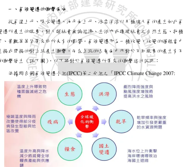
(33) 第二章 氣候變遷模擬與災害衝擊. 第二章 氣候變遷模擬與災害衝擊 跨政府氣候變遷小組(Intergovernmental Panel on Climate Change, IPCC) 近年來公布的氣候變遷評估報告指出,即使目前溫室氣體減量達一定成效,未來的 全球溫度仍會成長,氣候變遷仍然會發生,所造成的天然災害威脅,如乾旱、颱風、 豪雨、熱浪與暴風雪等近年來在世界各地所造成的災情也屢破歷史紀錄,而未來帶 來的衝擊影響可能是更全面的,可能因為氣候變遷的關係導致劇烈降雨強度與颱風 強度增加,加上社會經濟發展與環境變遷等因素,洪澇災害發生之規模、風險與損 失將更為提高;除了直接的天然災害衝擊外,生態系統的危機、疾病發生的型態與 地區的改變,以及因溫度升高與降水改變對農業與糧食的衝擊,都是氣候變遷將對 全球尤其是人口密度甚高之亞太地區的經濟社會帶來嚴重威脅(陳亮全,2007)。 各國面對氣候變遷之議題可分兩大方向,一為氣候變遷的防治,主要針對溫室 氣體排放與管制方面的政策;另一為氣候變遷所致生態環境系統改變所須因應對 策。除了溫室氣體控制外,如何做好氣候變遷調適成為對抗氣候變遷衝擊的另一重 要關鍵議題。調適工作乃是因應氣候變遷的可能衝擊,預先進行調適方法,將衝擊 降至最低。但氣候變遷影響層面之廣,各層面所需的評估工具與資訊大不同,如何 進行適當的調適策略為國際社會一大挑戰。本章根據 IPCC 2007 氣候變遷評估報告 與台大全球變遷研究中心的模擬資料,整理氣候變遷現象與未來情境模擬料、衝 擊、調適與脆弱度、減緩氣候變遷的資料,作為後續章節之基礎。. 9.
(34) 以荷蘭氣候變遷減災調適經驗探討我國空間規劃策略方向-與水共生的空間. 第一節 國內外氣候變遷現象與未來情境模擬 為因應氣候變遷可能產生之災害,決策者需瞭解氣候變化的成因,潛在環境和 社會經濟的衝擊影響,及可能的因應對策,世界氣象組織(World Meteorological Organization, WMO)與聯合國環境規劃署(United Nations Environment Programme, UNEP)在 1988 年成立跨政府氣候變遷小組(Intergovernmental Panel on Climate Change, IPCC),IPCC 在全面、客觀、公開與透明基礎上,彙整有關全球氣候變遷 最好的科學、技術和社會經濟研究成果與資訊,以發行評估報告等方式,針對全球 氣候變遷的議題提供決策者、科學家與專家參考。 一、. 氣候變遷的定義. 氣候變遷是氣候狀態的變化,而這種變化能通過其特性的平均值或變異率的變 化予以界定(如運用統計檢定),而持續一段延伸的時間,通常幾十年或更長時期。 氣候變遷的原因可能是由於自然內部過程或各種外力,或是由於大氣成分和土地利 用中持續的人為變化。而在「聯合國氣候變遷綱要會議」(UNFCC)第一條將氣候 變遷定義為「在可比較時期內所觀測到、在自然氣候變異外的直接、間接歸因於人 類活動而改變全球大氣成分所致。」,因此 UNFCC 對可歸因於人類活動而改變大氣 成分的氣候變遷、以及歸因於自然的氣候變異做出區別(IPCC,2007)。 二、IPCC 氣候變遷評估報告(2007,AR4) (一)歷次評估報告的提出 IPCC 第一次評估報告於 1990 年發表,促使聯合國大會制訂氣候變遷公約 (UNFCCC),1995 年 IPCC 發表第二次評估報告『Climate Change 1995』對京都議定 書做出貢獻,2001 年第三次評估報告『Climate Change 2001』及 2007 年第四次評 估報告『Climate Change 2007』,更是結合了 130 多個國家,超過 2500 名科學家 所做出的完整評估報告,分別針對氣候變遷的現象、成因與氣候變遷所造成的衝 擊、調適與脆弱度提出完整報告,並對如何減緩氣候變遷提出整體整合評估。 (二)IPCC 評估報告內容摘要 IPCC 2007 年分四次公布不同主題之評估報告,包括第一工作小組的「氣候變. 10.
(35) 第二章 氣候變遷模擬與災害衝擊. 遷科學基礎」、第二工作小組的「氣候變遷之衝擊、調適及脆弱度」與第三工作小 組的「減緩氣候變遷」,最後發表總結報告,各主題與發佈時間與內容如下圖:. IPPC 2007 發 布 之 評 估 報 告. WGⅠ:氣候變遷科學基礎 The Physical Science Basis. Paris, 2 February, 2007. WGⅡ:氣候變遷衝擊、調適與脆弱度 Climate Change Impact, Adaptation and Vulnerability WGⅢ:減緩氣候變遷 Mitigation of Climate Change 整合報告 Synthesis Report. 圖 2-1. Brussel, 6, April, 2007. Bangkok, 4 May, 2007. Valencia, 12-16 November, 2007. IPCC2007 評估報告內容與發布時間 (資料來源:IPCC,2007). (三)目前所觀測到的氣候變遷 IPCC 2007 AR4 公布評估報告之重點摘要內容彙整如下: 1、氣候系統之暖化現象已經被認為是非常明確的(),全球平均溫度及海平面高 度在過去 100 年皆有上升趨勢,過去 100 年(1906-2005)全球平均溫度增幅為 0.74 ℃,已較 IPCC 2001 中之所觀測之 100 年(1901-2000)增幅 0.6 ℃為大。 2、1961~2003 年全球海平面高度以平均每年 1.8 毫米的速度在上升,而 1993~2003 年這段時間上升的速度增加為每年 3.1 毫米,而北半球之冰雪覆蓋面積 在 80 年代後有明顯下降。 3、全球陸地溫度增加速度較海溫為快,而極地之溫度增幅為全球平均的兩倍。 4、大部份陸地豪大雨發生的頻率與有增加的趨勢,整體降雨量的變遷空間分 佈有所不同,在北美及南美之東部、北歐及中北亞皆有明顯之上升,而在撒哈拉、 地中海、南非及部份南亞有變乾之趨勢,同時在熱帶及亞熱帶很多地區觀測到較嚴 重及長期之乾旱。 5、各地之極端溫度皆起了變化,冷日、冷夜及出現霧之頻率明顯減少而暖日、 冷夜及出現熱浪之頻率增多。. 11.
(36) 以荷蘭氣候變遷減災調適經驗探討我國空間規劃策略方向-與水共生的空間. 6、強烈颱風之數目在北大西洋有所增加,但在台灣所處的西北太平洋並沒有 明顯趨勢。. 圖 2-2 過去 150 觀測到的全球平均溫度、海平面與北半球積雪變 化。(資料來源:IPCC,2007:氣候變遷 2007:綜合報告) (四) 變遷的原因 氣候變遷的探討,在許多的報告當中皆以工業革命為人類活動對大氣影響的起 始點,在過程中,追尋著重要論證為氣候變遷為自然演替或是人類活動所致,而 IPCC 的報告中也無法百分之百完全地確定其看法,只能以八種不同的「可能」程度來闡 釋研究報告中氣候變遷與人類活動的關係。不過,由 IPCC 第四版的報告指出,全 球氣候變遷的現象越來越明顯,人類活動對大氣系統的影響越來越深刻,甚至取代. 12.
(37) 第二章 氣候變遷模擬與災害衝擊. 了自然演替作用,並且,報告中亦認定人類活動「非常可能」為氣候變遷的主因。 IPCC 2007 認為從 20 世紀中葉開始全球暖化現象的原因非常可能(very likely,可能 性> 90%)是由人類活動所釋放之溫室氣體所引起,相較於 IPCC 2001 認為的可能程 度(likely,可能性> 66%),不確定性已大幅減少。 IPCC 第四版報告中,如下圖 3 之資料即可發現出溫室氣體巨幅成長的轉折時 間點恰巧約為工業革命時期的 1750 年後才開始,在 1750 年之前約為 275-285ppm, 但從 1750 年至 2005 年二氧化碳的濃度卻增加到 379ppm,在短短的時間之內約莫 增加了 100ppm,每年約增加有 2-3ppm。. 圖 2-3 溫室氣體增加趨勢 (資料來源:IPCC,2007) 導致氣候變遷的原因指向為人類開始大量利用生態資源、化石燃料以產生溫室 氣體,但也有多方認為絕大數的溫室氣體是來自於海洋,為自然演替為冰河時期的 現象,但不論如何溫室氣體的產生改變了地球大氣循環與運行狀態,而產生了過去 在有科學氣象記錄以來未曾出現過的氣候異常現象,以及未來各地區氣候變化趨勢 的改變,氣候變遷現象眾多且不斷有新的現象出現。 三、未來氣候變遷之情境模擬 IPCC 的研究報告中針對未來人類面臨氣候變遷的發展模擬如下幾種情境:. 13.
(38) 以荷蘭氣候變遷減災調適經驗探討我國空間規劃策略方向-與水共生的空間. 1.. A1:為一個經濟快速發展的未來世界,全球人口在世紀中達到頂端後開始 下降,新的更高的技術被迅速採用,隨著區域間平均所得差異縮小,基本 活動主題主要表現,地區間的融合增加,能力建設增強,以及文化和社會 間增加的交互作用。A1 情境可分為三個組合描述 A1 系統中技術變化分 別:A1F:化石能源、A1T:非化石能源、A1B:所有資源平衡協調利用 (不過份依賴某一種)。. 2.. A2:此為一個非常不均衡的世界,主要為自給自足以地方性經濟為主的情 境,人口、經濟持續的成長,技術的進步較其他情境緩慢且零散。. 3.. B1:全球人口達到顛峰開始下降,經濟結構趨向於服務業為主的社會,經 濟變化迅速,材料密集程度下降,並且採用清潔、高效資源技術,強調經 濟、社會、環境的持續性,包括增加平等性等方面的全球性解決方案。. 4.. B2:焦點及終於社會、經濟、環境持續發展的地方性方案,隨著低於 A2 速率的持續性人口增長,經濟發展則處於中等水平,與 A1、B1 相比,技 術變更緩慢且種類增多,主要強調地方和區域性水平的層次。. IPCC 第四次報告中對此四種情境下進行模擬,並在不同的社會、經濟與科技 發展程度下,預測在四種情境下 2100 年時的二氧化碳含量,見下表與下圖,預測 結果發現若將 2090-2099 年溫度與 1980-1999 年之平均溫度相比較,可估計地表溫 度將升高 1.8℃-4℃,而四個情境當中以 B1 情境增溫的情形較為緩和,A2 情境增 溫的幅度最大。而升溫狀況將視 2100 年前有多少 CO2 進入大氣層而定,當 CO2 濃 度增加至工業革命前的兩倍左右(550ppm)時,全球平均氣溫增加 4.5℃甚至更高。. 表 2-1 21 世紀末全球平均地表溫度升高與海平面上升預估. (資料來源:IPCC,2007). 14.
(39) 第二章 氣候變遷模擬與災害衝擊. 圖 2-4 2090-2099 年與 1980-1999 年預測之氣溫差距 (資料來源:IPCC,2007) 摘要歸納未來氣候變遷在不同情境模擬結果如下: (一)平均氣溫上升 考量不同情境的溫室氣體排放程度,模式預估未來 2000-2100 年之全球平均溫 度將上升 1.8℃(低溫室氣體排放情境)至 4℃ (高溫室氣體排放情境),極端情況溫度 會上升 6.4℃,上升區域集中在陸地及北半球較高緯度地區。 (二)海平面高度上升 到 2100 年海平面高度上升幅度最嚴重的情形為上升 59cm,平均上升高度約為 10~20cm。 (三)總降雨量 總降雨量在高緯度地區可能增多,而在副熱帶地區的陸地雨量會減少;針對東亞 地區的預估,冬天雨量減少、夏天雨量增多。 (四)極端事件頻率 熱浪及豪大雨之頻率極可能會持續增多,乾旱的強度與頻率將會增加,而由於 海溫升高,未來之颱風可能更強及伴隨更大之降雨。. 15.
(40) 以荷蘭氣候變遷減災調適經驗探討我國空間規劃策略方向-與水共生的空間. 四、臺灣氣候變遷模擬 氣候變遷對人類所產生之可能衝擊,必須採用多種全球模式對多種情境進行模 擬,再將其結果加以綜合分析以提供未來氣候之不確定性解釋,其中在溫室氣體排 放之情境模擬中,根據 IPCC 所公佈之社經情境模擬之數據,以 SRES-A2 和 SRES-B2 最常被使用,通常前者對於未來溫室氣體的預期排放量模擬較後者為多。目前臺灣 大學全球變遷中心運用日本 CCS(CCSR/NIES AGCM+CCSR OGCM, Center for Climate System Research National Institute for Environmental Studies)模式完成台灣地 區氣候降尺度模擬資料進行氣溫及雨量的變遷模擬,並以 SRES-A2、SRES-B2 兩個 情境進行全台灣地區氣候之模擬,以下將針對台灣地區之氣溫及雨量模擬結果作說 明(何明錦,2008)。 經由模擬結果可知,不管是 SRES-A2 或 SRES-B2,在溫度變化方面都有逐漸 增高的趨勢,只是 SRES-A2 比 SRES-B2 升高幅度較大,溫度也都較高,主要是因 為兩者對於未來生活環境之友善程度不同。從 2000 年、2050 年、2090 年的年平均 溫度方面(圖 2-5、圖 2-6)來看,平原地區溫度仍是比山區較高,靠近山區之平均 溫度從 2000 年之 14℃左右上升到 2090 年將近 22℃,而平原地區則是從 2000 年氣 溫大約在 22~23℃左右,逐漸上升到 2050 年約為 23~25℃左右,若到 2090 年年平 均氣溫已將近 28~30℃,特別是台北盆地與西南沿海平原,溫度上升幅度相當大。 從整體的年平均溫度來看,不管是 SRES-A2 或 SRES-B2 的年平均溫度皆是上 升,但還是生長可容忍之溫度範圍內。下面將針對夏季(6、7、8 月)平均溫度與 冬季(12、1、2 月)平均溫度之模擬結果作分析說明,SRES-A2 中 2000 年、2050 年、2090 年之夏季平均溫度約落在 7~33℃之間(圖 2-7) ,冬季平均溫度從 0~25℃ (圖 2-8) ;而 SRES-B2 中 2000 年、2050 年、2090 年之夏季平均溫度約落在 7~31℃ 之間(圖 2-9) ,冬季平均溫度則是從-2~25℃(圖 2-10) ,由此可知,在夏季平均溫 度 SRES-A2 較 SRES-B2 之溫度落差較大,冬季平均溫度反而是 SRES-B2 溫差較 SRES-A2 大,由數據中可知,SRES-A2 不管是在夏季或冬季所模擬出之氣候結果, 比 SRES-B2 溫度要高,且至 2090 年溫度上升幅度相當大。 由台灣地區夏季平均溫度之模擬結果(圖 2-7、圖 2-8)可看出,在 SRES-A2 和 SRES-B2 下,台灣地區平原地帶在 2050 年時,平均溫度已達到 27~29℃,若再 往後 40 年到 2090 年時,平均溫度已達到 29~31℃,在 SRES-A2 的模擬下,更有部. 16.
(41) 第二章 氣候變遷模擬與災害衝擊. 分地區之平均溫度上達 33℃,氣溫上升之速度是很驚人的,並且溫度較高之地區, 多為人口集中或農作物主要生長之區域,如:台北盆地、西南沿海平原以及蘭陽平 原與屏東墾丁一帶,未來確實需更加重視高溫頻率較高之地區,以防範氣候變遷所 造成之危害。 冬季平均氣溫方面(圖 2-8、圖 2-10),在 2000 年時,SRES-A2 與 SRES-B2 的冬季平均溫度相差不多,直到 2050 年仍然維持此現象,人口聚集之平源冬季平 均溫度約 20℃左右,當時間來到 2090 年時,SRES-A2 的平均溫度則與 SRES-B2 的平均溫度相當,約在 20~23℃間,而兩者在中南部之平均溫度較北部地區高,北 部地區除台北盆地溫度較高外,其餘皆在 20℃左右,緯度越低溫度逐漸升高,南部 地區高雄、屏東冬季平均溫度都高達 24、25℃,此現象除了顯示冬季溫度與夏季溫 度一樣持續上升外,也顯示出 SRES-A2 在冬季溫度上升幅度較大,SRES-B2 在冬 季溫度上升幅度較小,不過不管在哪種情境下,未來台灣地區之溫度皆是呈現持續 上升的情況,是值得加以重視的,特別是在溫度上升幅度較大之地區。 降雨量之模擬主要分為雨季(5-9 月)平均降雨量以及乾季(10-12、1-4 月) 平均降雨量,在雨季平均降雨量方面(圖 2-11、圖 2-13) ,無論是 SRES-A2 或 SRES-B2 之模擬結果,從 2000 年到 2050 年而後到 2090 年間之變化情形,大致上皆呈現降 雨量逐漸上升後下降的趨勢,不過變動的幅度依模式之不同而不一,在 SRES-A2 下,從 2000 年 3mm~25mm 間,逐漸增加到 2050 年的 6mm~70mm 之間,再逐漸減 少至 2090 年 4mm~31mm 間,在 SRES-B2 下,從 2000 年 4mm~23mm 間,逐漸增 加到 2050 年 6mm~40mm 之間,微幅減少至 2090 年 3mm~39mm 間;在乾季平均降 雨量方面(圖 2-12、圖 2-14),則無上述波動較大之情況,並且兩種模擬情境變動 幅度皆不大,SRES-A2 在此三年之平均降雨量大約都落在 0mm~18mm 之間,各年 間 乾 季 平 均 降 雨 量 差 異 不 大 , SRES-B2 在 此 三 年 之 平 均 降 雨 量 也 都 約 落 在 0mm~23mm 之間,SRES-B2 之乾季平均降雨量較 SRES-A2 要來的多。 由台灣地區降雨量之模擬結果分布圖可知,降雨量在空間分布上,無論是 SRES-A2 或 SRES-B2 大致上呈現一致的狀態,降雨量較多之地區,在未來幾年仍 然維持較多之降雨量,反之亦然。在雨季方面,雨量較多之地區多位於宜蘭山區以 及南部山區,西部沿海平原相對而言降雨量較少;而乾季雨量較多之地區,則位於 東北角海岸地區,以及宜蘭縣地帶,乾季降雨量較少之地區與雨季相同都為西部沿. 17.
(42) 以荷蘭氣候變遷減災調適經驗探討我國空間規劃策略方向-與水共生的空間. 海平原,比較特別的是在乾季降雨量較多之地區多位於北部區域,雨季降雨量較多 之地區則多位於南部地區,未來對於水資源之規劃應謹慎考量降雨量之分布情況與 變化情形。. 圖 2-5 台灣地區年平均溫度分布圖(SRES-A2) 資料來源:全球變遷研究中心. 圖 2-6 台灣地區年平均溫度分布圖(SRES-B2) 資料來源:全球變遷研究中心. 18.
(43) 第二章 氣候變遷模擬與災害衝擊. 圖 2-7 台灣地區夏季平均溫度分布圖(SRES-A2) 資料來源:全球變遷研究中心. 圖 2-8 台灣地區冬季平均溫度分布圖(SRES-A2) 資料來源:全球變遷研究中心. 19.
(44) 以荷蘭氣候變遷減災調適經驗探討我國空間規劃策略方向-與水共生的空間. 圖 2-9 台灣地區夏季平均溫度分布圖(SRES-B2) 資料來源:全球變遷研究中心. 圖 2-10 台灣地區冬季平均溫度分布圖(SRES-B2) 資料來源:全球變遷研究中心. 圖 2-11 台灣地區雨季平均降雨量分布圖(SRES-A2) 資料來源:全球變遷研究中心. 20.
(45) 第二章 氣候變遷模擬與災害衝擊. 圖 2-12 台灣地區乾季平均降雨量分布圖(SRES-A2) 資料來源:全球變遷研究中心. 圖 2-13 台灣地區雨季平均降雨量分布圖(SRES-B2) 資料來源:全球變遷研究中心. 圖 2-14 台灣地區乾季平均降雨量分布圖(SRES-B2) 資料來源:全球變遷研究中心. 21.
數據


+7


相關文件
The MNE subject, characterised by its (i) curriculum structure; (ii) curriculum aims; (iii) learning and teaching strategies; and (iv) curriculum contents, can enhance the
Besides learning opportunities such as morning assemblies, school assemblies, class teacher periods and co-curricular activities, schools also make use of other
Apart from spelling out clearly the curriculum objectives, content and learning strategies of moral and national education, related curriculum resources and
A study on the spatial orientation ability for sixth grader students of elementary school― using three-dimensional views (Unpublished master’s thesis). National
As is known, practices of Medicine Buddha correspond to the concept of development of the pure land in the human world; since Master Taixu, Master Hong Yi and Master Yin Shun in
Final report to the national forum on information
The Buddha established vinaya according to wholes-ome social customs, morality, and reasonable national laws and regulations in combination with correct Buddhist knowledge and
Kielsmeier (2002) “Recasting the Role of Youth in the 21st Century: Active Learning and Civic Engagement” Paper presented in the National Service-Learning Conference 2002:
